Goshen, New Hampshire
| Goshen, New Hampshire | |
|---|---|
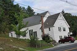 Town Hall | |
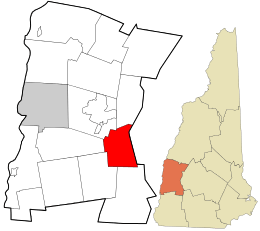 Location in Sullivan County and the state of New Hampshire | |
| Coordinates: 43°18′04″N 72°08′52″W / 43.30111°N 72.14778°WCoordinates: 43°18′04″N 72°08′52″W / 43.30111°N 72.14778°W | |
| Country | United States |
| State | New Hampshire |
| County | Sullivan |
| Incorporated | 1791 |
| Villages |
Goshen Goshen Four Corners |
| Government | |
| • Board of Selectmen |
Robert Bell, Chair Bruce Nadeau Douglas O'Clair |
| Area | |
| • Total | 22.6 sq mi (58.5 km2) |
| • Land | 22.5 sq mi (58.2 km2) |
| • Water | 0.08 sq mi (0.2 km2) 0.40% |
| Elevation | 971 ft (296 m) |
| Population (2010) | |
| • Total | 810 |
| • Density | 36/sq mi (14/km2) |
| Time zone | UTC-5 (Eastern) |
| • Summer (DST) | UTC-4 (Eastern) |
| ZIP code | 03752 |
| Area code(s) | 603 |
| FIPS code | 33-30500 |
| GNIS feature ID | 0873608 |
| Website |
www |
Goshen is a town in Sullivan County, New Hampshire, United States. The population was 810 at the 2010 census.[1]
History
Incorporated in 1791, Goshen was first settled in 1768 as a part of Saville (now Sunapee). The name Goshen may have been taken from Goshen, Connecticut, where many residents had relatives.
Geography
According to the United States Census Bureau, the town has a total area of 22.6 square miles (59 km2), of which 22.5 sq mi (58 km2) is land and 0.1 sq mi (0.26 km2) is water, comprising 0.40% of the town. The long ridge of Mount Sunapee occupies the eastern edge of town. The highest point in Goshen is an unnamed knob on the ridge (near Goves Mountain) where the elevation reaches 2,529 feet (771 m) above sea level. Goshen lies almost fully within the Connecticut River watershed, though a small corner in the southeast of town is in the Merrimack River watershed.[2]
Demographics
| Historical population | |||
|---|---|---|---|
| Census | Pop. | %± | |
| 1800 | 383 | — | |
| 1810 | 563 | 47.0% | |
| 1820 | 687 | 22.0% | |
| 1830 | 772 | 12.4% | |
| 1840 | 779 | 0.9% | |
| 1850 | 659 | −15.4% | |
| 1860 | 576 | −12.6% | |
| 1870 | 507 | −12.0% | |
| 1880 | 511 | 0.8% | |
| 1890 | 384 | −24.9% | |
| 1900 | 345 | −10.2% | |
| 1910 | 329 | −4.6% | |
| 1920 | 283 | −14.0% | |
| 1930 | 255 | −9.9% | |
| 1940 | 352 | 38.0% | |
| 1950 | 356 | 1.1% | |
| 1960 | 351 | −1.4% | |
| 1970 | 395 | 12.5% | |
| 1980 | 549 | 39.0% | |
| 1990 | 742 | 35.2% | |
| 2000 | 741 | −0.1% | |
| 2010 | 810 | 9.3% | |
| Est. 2015 | 807 | [3] | −0.4% |
| U.S. Decennial Census[4] | |||
As of the census[5] of 2000, there were 741 people, 279 households, and 219 families residing in the town. The population density was 32.9 people per square mile (12.7/km²). There were 389 housing units at an average density of 17.3 per square mile (6.7/km²). The racial makeup of the town was 97.03% White, 1.62% Native American, 0.13% Asian, 0.13% from other races, and 1.08% from two or more races. Hispanic or Latino of any race were 0.40% of the population.
There were 279 households out of which 33.3% had children under the age of 18 living with them, 64.5% were married couples living together, 9.7% had a female householder with no husband present, and 21.5% were non-families. 17.2% of all households were made up of individuals and 7.2% had someone living alone who was 65 years of age or older. The average household size was 2.63 and the average family size was 2.96.
In the town, the population was spread out with 24.2% under the age of 18, 8.0% from 18 to 24, 27.5% from 25 to 44, 26.7% from 45 to 64, and 13.6% who were 65 years of age or older. The median age was 40 years. For every 100 females, there were 97.6 males. For every 100 females age 18 and over, there were 96.5 males.
The median income for a household in the town was $42,625, and the median income for a family was $45,208. Males had a median income of $33,333 versus $22,727 for females. The per capita income for the town was $20,561. About 6.9% of families and 8.8% of the population were below the poverty line, including 10.8% of those under age 18 and 21.5% of those age 65 or over.
Education
Goshen and the neighboring town of Lempster maintained a combined elementary and middle school, called Goshen-Lempster Cooperative School, located in Lempster. The school served kindergarten through 8th grade. The cooperative was dissolved in June 2016. The majority of Goshen elementary and middle-school aged children now attend Newport, NH schools; the Newport school system now acts as the anchor system for Goshen students.
After 8th grade, students are given the choice to attend several neighboring high schools, including Newport High School, Sunapee Senior High School, and Kearsarge Regional High School.
Notable people
- John Williams Gunnison, US Army officer and explorer of the American West
References
- ↑ United States Census Bureau, American FactFinder, 2010 Census figures. Retrieved March 23, 2011.
- ↑ Foster, Debra H.; Batorfalvy, Tatianna N.; Medalie, Laura (1995). Water Use in New Hampshire: An Activities Guide for Teachers. U.S. Department of the Interior and U.S. Geological Survey.
- ↑ "Annual Estimates of the Resident Population for Incorporated Places: April 1, 2010 to July 1, 2015". Archived from the original on June 2, 2016. Retrieved July 2, 2016.
- ↑ "Census of Population and Housing". Census.gov. Archived from the original on May 12, 2015. Retrieved June 4, 2016.
- ↑ "American FactFinder". United States Census Bureau. Archived from the original on 2013-09-11. Retrieved 2008-01-31.
External links
| Wikimedia Commons has media related to Goshen, New Hampshire. |
- Town of Goshen official website
- New Hampshire Economic and Labor Market Information Bureau Profile
- Sunapee-Ragged-Kearsarge Greenway Coalition
Places adjacent to Goshen, New Hampshire | |
|---|---|
Municipalities and communities of Sullivan County, New Hampshire, United States | ||
|---|---|---|
| City | 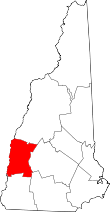 | |
| Towns | ||
| CDPs | ||
| Other villages | ||