Rye, New Hampshire
| Rye, New Hampshire | ||
|---|---|---|
| Town | ||
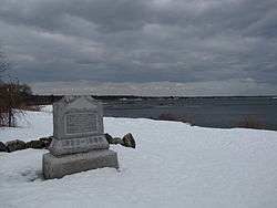 1899 monument marking presumed landing place of 1623 | ||
| ||
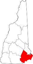
 Location in Rockingham County and the state of New Hampshire. | ||
| Coordinates: 43°00′48″N 70°46′15″W / 43.01333°N 70.77083°WCoordinates: 43°00′48″N 70°46′15″W / 43.01333°N 70.77083°W | ||
| Country | United States | |
| State | New Hampshire | |
| County | Rockingham | |
| Founded | 1623 | |
| Incorporated | 1726 | |
| Villages |
Rye Rye Beach Rye Harbor Cable Road Fairhill Manor Foyes Corner Langs Corner West Rye | |
| Government | ||
| • Board of Selectmen |
Priscilla V. Jenness, Chair Philip D. Winslow Keriann Roman | |
| Area | ||
| • Total | 36.7 sq mi (95.1 km2) | |
| • Land | 12.6 sq mi (32.7 km2) | |
| • Water | 24.1 sq mi (62.4 km2) 65.65% | |
| Elevation | 75 ft (23 m) | |
| Population (2010) | ||
| • Total | 5,298 | |
| • Density | 140/sq mi (56/km2) | |
| Time zone | UTC−5 (Eastern) | |
| • Summer (DST) | UTC−4 (Eastern) | |
| ZIP code | 03870 | |
| Area code(s) | 603 | |
| FIPS code | 33-66180 | |
| GNIS feature ID | 0873712 | |
| Website |
www | |
Rye is a town in Rockingham County, New Hampshire, United States. The population was 5,298 at the 2010 census.[1] The town is home to several state parks along the Atlantic coastline.
History
The first settlement in New Hampshire, originally named Pannaway Plantation, was established in 1623 at Odiorne's Point[2] by a group of fishermen led by David Thompson. The settlement was abandoned in favor of Strawberry Banke which became Portsmouth. The first settler in present-day Rye was probably William Berry.[3] Prior to its incorporation in 1726 as a parish of New Castle, Rye was called "Sandy Beach" and included land in New Castle, Portsmouth, Greenland and Hampton.[4]

Geography
According to the United States Census Bureau, the town has a total area of 36.7 square miles (95.1 km2), of which 12.6 square miles (32.6 km2) is land and 24.1 square miles (62.4 km2) is water, comprising 65.65% of the town.[5] The town is located on the shore of the Atlantic Ocean and includes four of the nine islands known as the Isles of Shoals, which lie approximately 10 miles (16 km) out from the mainland. The highest point in Rye is the summit of Breakfast Hill, at 151 feet (46 m) above sea level, on the town's border with Greenland.
Rye is bordered by the Atlantic Ocean to the east, New Castle to the northeast, Portsmouth to the northwest, Greenland to the west, and North Hampton to the south.
State parks in Rye along the Atlantic shoreline include (from south to north) Jenness State Beach, Rye Harbor State Park, Wallis Sands State Beach, and 135-acre (55 ha) Odiorne Point State Park, home to the Seacoast Science Center.
Route 1A, going north-south, follows the coast. Short segments of U.S. Route 1 and Route 1B enter Rye. The nearest major highway is I-95, with the closest two exits in Hampton and Portsmouth. The nearest commercial airport is Portsmouth International Airport; the two closest major airports are Logan Airport in Boston and Portland International Jetport.
The unincorporated community of Rye Beach is in the southern part of the town. Rye Beach has its own U.S. post office, as well as its own zoning enforcement and planning regulations.[6]
Demographics
| Historical population | |||
|---|---|---|---|
| Census | Pop. | %± | |
| 1790 | 865 | — | |
| 1800 | 890 | 2.9% | |
| 1810 | 1,020 | 14.6% | |
| 1820 | 1,127 | 10.5% | |
| 1830 | 1,172 | 4.0% | |
| 1840 | 1,205 | 2.8% | |
| 1850 | 1,295 | 7.5% | |
| 1860 | 1,199 | −7.4% | |
| 1870 | 993 | −17.2% | |
| 1880 | 1,111 | 11.9% | |
| 1890 | 978 | −12.0% | |
| 1900 | 1,142 | 16.8% | |
| 1910 | 1,014 | −11.2% | |
| 1920 | 1,196 | 17.9% | |
| 1930 | 1,081 | −9.6% | |
| 1940 | 1,246 | 15.3% | |
| 1950 | 1,982 | 59.1% | |
| 1960 | 3,244 | 63.7% | |
| 1970 | 4,083 | 25.9% | |
| 1980 | 4,508 | 10.4% | |
| 1990 | 4,612 | 2.3% | |
| 2000 | 5,182 | 12.4% | |
| 2010 | 5,298 | 2.2% | |
| Est. 2015 | 5,375 | [7] | 1.5% |
| U.S. Decennial Census[8] | |||
As of the census of 2010, there were 5,298 people, 2,252 households, and 1,531 families residing in the town. There were 2,852 housing units, of which 600, or 21.0%, were vacant. 471 of the vacant units were for seasonal or vacation use. The racial makeup of the town was 97.8% white, 0.3% African American, 0.02% Native American, 0.9% Asian, 0.04% Native Hawaiian or Pacific Islander, 0.2% some other race, and 0.8% from two or more races. 1.1% of the population were Hispanic or Latino of any race.[9]
Of the 2,252 households, 26.3% had children under the age of 18 living with them, 56.3% were headed by married couples living together, 8.1% had a female householder with no husband present, and 32.0% were non-families. 25.4% of all households were made up of individuals, and 10.9% were someone living alone who was 65 years of age or older. The average household size was 2.34, and the average family size was 2.80.[9]
In the town, 20.3% of the population were under the age of 18, 4.3% were from 18 to 24, 18.2% from 25 to 44, 37.5% from 45 to 64, and 19.7% were 65 years of age or older. The median age was 48.8 years. For every 100 females, there were 95.1 males. For every 100 females age 18 and over, there were 93.8 males.[9]
For the period 2012-2016, the estimated median annual income for a household was $99,417, and the median income for a family was $122,064. Male full-time workers had a median income of $60,368 versus $50,588 for females. The per capita income for the town was $60,071. 5.1% of the population and 2.3% of families were below the poverty line. 4.4% of the population under the age of 18 and 5.6% of those 65 or older were living in poverty.[10]
Politics
As of 2004, 1,345 registered voters in Rye were Democrats and 1,815 were registered Republicans.[11]
In August 2001, a group of townspeople from Newington and Rye made a plea in protest to the state legislature to consider allowing the town to secede from the state due to disproportionate property tax laws which had been passed by the state in 1997 to balance the state's education economy.[12] The dispute was largely quelled by the lack of support for the movement, as only 52 of Newington's 700+ (and 100 of Rye's 5,000) residents signed the petition. The property tax issue itself quieted as Governor Craig Benson announced in 2003 the property taxes would be cut almost by half by 2008.
Education
Children who live in Rye can attend public schools in town from kindergarten through eighth grade. School Administrative Unit 50 (SAU-50) is the school district that serves Rye, as well as the towns of Greenland, Newington, and New Castle. High school students from Rye attend Portsmouth High School.
Rye Elementary School is home to kindergarten through fifth grade and is the first and largest school students from Rye will attend in SAU-50. All grades are co-ed and the school has an 11 to 1 student per teacher ratio with three hundred and thirty students enrolled in October 2013. Rye Junior High handles grades six, seven, and eight. The neighboring town of New Castle sends its students to Rye Junior High after sixth grade, but only contributes a few students to each year's seventh grade class. All grades are coed and contain two hundred and twenty students as of October 2013 with a ratio of nine students to each teacher.
There are two private pre-schools in the town. Rye Country Day is the larger of the two pre-schools in town, currently enrolling one hundred and forty students (as of October 2013). The second, The Children's House Montessori school, is located at 80 Sagamore Road and has a student per teacher ratio of eleven to one.
Learning Skills Academy is a private non-profit school catering to students with learning capabilities. The organization has a location at 1237 Washington Road in Rye and accepts students in fifth through eleventh grade, as well as third. 32 kids make up the student body at the Rye location as of October 2013.
Notable people
- Craig Benson, 79th governor of New Hampshire
- William Berry, first settler of Rye
- Dan Brown, author (The Da Vinci Code)[13]
- Scott Brown, former U.S. senator from Massachusetts
- Judd Gregg, 76th governor of New Hampshire and U.S. senator[14]
- Chip Kelly, head football coach, UCLA Bruins[15]
- Dave O'Brien, ESPN play-by-play announcer, television voice of the Boston Red Sox on NESN
- Herbert Philbrick, advertising executive and business owner in Rye; paid by the FBI to infiltrate the Communist Party USA in the 1940s (see: I Led Three Lives)
- Laurence Tosi, Chief Financial Officer of Airbnb
- Liv Tyler, actress and daughter of Steven Tyler
In culture
Rye was the setting (in part) of the short story "Marjorie Daw" by Thomas Bailey Aldrich (1836-1907).[16]
References
Specific
- ↑ United States Census Bureau, American FactFinder, 2010 Census figures. Retrieved March 23, 2011.
- ↑ Charles W. Brewster. "Old Pannaway:First NH Settlement". SeacoastNH.com. Retrieved 2008-08-01.
- ↑ Arthur H. Locke, A History and Genealogy of Captain John Locke, pg 2
- ↑ Langdon Parsons, History of the Town of Rye, pg 38
- ↑ "Geographic Identifiers: 2010 Demographic Profile Data (G001) - Rye town, New Hampshire". U.S. Census Bureau American Factfinder. Retrieved November 15, 2011.
- ↑ "Rye Beach Village District". Retrieved 2017-03-17.
- ↑ "Annual Estimates of the Resident Population for Incorporated Places: April 1, 2010 to July 1, 2015". Archived from the original on June 2, 2016. Retrieved July 2, 2016.
- ↑ "Census of Population and Housing". Census.gov. Retrieved June 4, 2016.
- 1 2 3 "Profile of General Population and Housing Characteristics: 2010 Census Summary File 1 (DP-1): Rye town, Rockingham County, New Hampshire". American Factfinder. U.S. Census Bureau. Retrieved February 7, 2018.
- ↑ "Selected Economic Characteristics: 2012-2016 American Community Survey 5-Year Estimates (DP03): Rye town, Rockingham County, New Hampshire". American Factfinder. U.S. Census Bureau. Retrieved February 7, 2018.
- ↑
- ↑ Burnett, Carl (August 14, 2001). "Many N.H. towns protest taxes". The Dartmouth. Retrieved 2007-01-26.
- ↑ Carbone, Gina (July 27, 2008). "Release date reportedly set for Dan Brown's new book". Seacoast Online. Retrieved March 7, 2017.
- ↑ Leah Goldman (July 20, 2011). "Check Out The House Goldman Sachs Advisor Judd Gregg Is Trying To Sell For $4.9 Million". Business Insider. Retrieved May 7, 2012.
- ↑ https://uclabruins.com/staff.aspx?staff=2674. Missing or empty
|title=(help) - ↑ "Marjorie Daw". Retrieved Feb 9, 2016.
General
- Parsons, Langdon B. (1905). History of the Town of Rye New Hampshire. Concord, NH: Rumford Printing Co.
External links
- Town of Rye official website
- Rye Historical Society and Town Museum
- New Hampshire Economic and Labor Market Information Bureau Profile
- Rye Junior High School
- Rye Reflections senior journal (2005-2010)
- Fort Dearborn from American Forts Network
Places adjacent to Rye, New Hampshire | |
|---|---|