Plymouth, New Hampshire
| Plymouth, New Hampshire | ||
|---|---|---|
| Town | ||
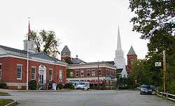 Town center (left to right): Plymouth Post Office, Rounds Hall of Plymouth State University (in background), Plymouth Congregational Church, Town Hall | ||
| ||
| Motto(s): Bridging the Lakes Region and the White Mountains | ||
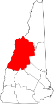
 Location in Grafton County, New Hampshire | ||
| Coordinates: 43°45′27″N 71°41′19″W / 43.75750°N 71.68861°WCoordinates: 43°45′27″N 71°41′19″W / 43.75750°N 71.68861°W | ||
| Country | United States | |
| State | New Hampshire | |
| County | Grafton | |
| Incorporated | 1763 | |
| Named for | Plymouth Colony, Massachusetts | |
| Villages |
Plymouth West Plymouth | |
| Government | ||
| • Board of Selectmen |
William Bolton, Chair John Randlett Mike Ahern Valerie Scarborough Bryan Dutille | |
| • Town Administrator | Paul Freitas | |
| Area | ||
| • Total | 28.7 sq mi (74.3 km2) | |
| • Land | 28.1 sq mi (72.8 km2) | |
| • Water | 0.6 sq mi (1.5 km2) 2.00% | |
| Elevation | 520 ft (158 m) | |
| Population (2010) | ||
| • Total | 6,990 | |
| • Density | 249/sq mi (96.0/km2) | |
| Time zone | UTC-5 (Eastern) | |
| • Summer (DST) | UTC-4 (Eastern) | |
| ZIP code | 03264 | |
| Area code(s) | 603 | |
| FIPS code | 33-62660 | |
| GNIS feature ID | 0873702 | |
| Website |
www | |
Plymouth is a town in Grafton County, New Hampshire, United States, in the White Mountains Region. Plymouth is located at the convergence of the Pemigewasset and Baker rivers. The population was 6,990 at the 2010 census.[1] The town is home to Plymouth State University, Speare Memorial Hospital, and Plymouth Regional High School.
The town's central settlement, where 4,456 people resided at the 2010 census[2] (a large number of whom are Plymouth State students), is defined as the Plymouth census-designated place (CDP), and is located along U.S. Route 3, south of the confluence of the Baker and Pemigewasset rivers.
History
Plymouth was originally the site of an Abenaki village that was burned to the ground by Captain Thomas Baker in 1712. This was just one of the many British raids on American Indian settlements during Queen Anne's War. Part of a large plot of undivided land in the Pemigewasset Valley, the town was first named New Plymouth, after the original Plymouth Colony in Massachusetts. Colonial Governor Benning Wentworth granted Plymouth to settlers from Hollis, all of whom had been soldiers in the French and Indian War. Some had originally come from Plymouth, Massachusetts. The town was incorporated in 1763.[3] Parts of Hebron and Campton were annexed in 1845 and 1860.
In 1806, then-lawyer Daniel Webster lost his first criminal case at the Plymouth courthouse, which now houses the Historical Society.[4] The author Nathaniel Hawthorne, while on vacation in 1864 with former U.S. President Franklin Pierce, died in Plymouth at the second Pemigewasset House, which was later destroyed by fire in 1909. In the early 20th century, the Draper and Maynard Sporting Goods Company (D&M) sold products directly to the Boston Red Sox, and players such as Babe Ruth would regularly visit to pick out their equipment. The Plymouth Normal School was founded in 1871 out of the already existing Holmes Plymouth Academy, becoming the state's first teachers' college. It would later evolve into Plymouth Teachers' College in 1939, Plymouth State College in 1963, and finally Plymouth State University in 2003.
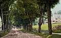 Main Street in 1908
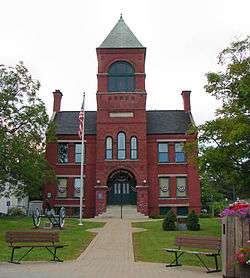
 Congregational Church and Town Hall c. 1920
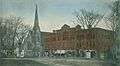 Kidder Block c. 1906
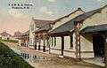 Railroad Station c. 1912
Geography
According to the United States Census Bureau, the town has a total area of 28.7 square miles (74.3 km2), of which 28.1 square miles (72.8 km2) are land and 0.58 square miles (1.5 km2) are water, comprising 2.00% of the town.[1] Plymouth is drained by the Pemigewasset and Baker rivers and lies within the Merrimack River watershed. Plymouth Mountain, elevation 2,193 feet (668 m) above sea level, the highest point in Plymouth, is in the south, and the slopes of Tenney Mountain are in the west. (The 2,310-foot (700 m) summit of Tenney Mountain lies in the town of Groton.)
The main village of Plymouth, a census-designated place, has a total area of 3.7 square miles (9.7 km2). 3.7 square miles (9.5 km2) of it are land and 0.077 square miles (0.2 km2) of it (2.31%) are water.
Demographics
| Historical population | |||
|---|---|---|---|
| Census | Pop. | %± | |
| 1790 | 625 | — | |
| 1800 | 743 | 18.9% | |
| 1810 | 937 | 26.1% | |
| 1820 | 983 | 4.9% | |
| 1830 | 1,175 | 19.5% | |
| 1840 | 1,282 | 9.1% | |
| 1850 | 1,290 | 0.6% | |
| 1860 | 1,407 | 9.1% | |
| 1870 | 1,409 | 0.1% | |
| 1880 | 1,719 | 22.0% | |
| 1890 | 1,852 | 7.7% | |
| 1900 | 1,972 | 6.5% | |
| 1910 | 2,200 | 11.6% | |
| 1920 | 2,353 | 7.0% | |
| 1930 | 2,470 | 5.0% | |
| 1940 | 2,533 | 2.6% | |
| 1950 | 3,039 | 20.0% | |
| 1960 | 3,210 | 5.6% | |
| 1970 | 4,225 | 31.6% | |
| 1980 | 5,094 | 20.6% | |
| 1990 | 5,811 | 14.1% | |
| 2000 | 5,892 | 1.4% | |
| 2010 | 6,990 | 18.6% | |
| Est. 2015 | 6,695 | [5] | −4.2% |
| U.S. Decennial Census[6] | |||
As of the census of 2010, there were 6,990 people, 1,953 households, and 947 families residing in the town. The population density was 248.8 people per square mile (96.0/km²). There were 2,231 housing units at an average density of 30.6 units/km² (79.4 units/sq mi). The racial makeup of the town was 95.6% White, 1.0% African American, 0.3% Native American, 1.1% Asian, 0.5% some other race, and 1.6% from two or more races. 1.9% of the population were Hispanic or Latino of any race.[7]
There were 1,953 households, out of which 24.1% had children under the age of 18 living with them, 37.1% were headed by married couples living together, 8.6% had a female householder whose husband did not live with her, and 50.1% were non-families. 28.6% of all households were made up of individuals, and 9.9% were someone living alone who was 65 years of age or older. The average household size was 2.41, and the average family size was 2.89.[7]

In the town, the population was spread out with 12.0% under the age of 18, 50.4% from 18 to 24, 13.3% from 25 to 44, 16.3% from 45 to 64, and 8.0% who were 65 years of age or older. The median age was 21.7 years. For every 100 females, there were 109.2 males. For every 100 females age 18 and over, there were 108.6 males.[7]
For the period 2009-2013, the estimated median annual income for a household in the town was $41,709, and the median income for a family was $79,453. Male full-time workers had a median income of $52,297 versus $28,851 for females. The per capita income for the town was $19,804. 22.5% of the population and 3.3% of families were below the poverty line. Out of the total people living in poverty, 4.3% were under the age of 18 and 9.8% were 65 or older.[8]
Recreation
.jpg)
- Fox Pond Park
- Langdon Park
- Walter-Newton Natural Area
- Sutherland Hiking Trail (on Plymouth Mountain)
Sites of interest
- Plymouth Historical Museum
- Pease Public Library
- Lamson Library
- Boy Scout Fountain on the Common (one of only two Boy Scout Fountains in the USA)
- Fox Park
- Langdon Beach
- Smith Millennium Bridge (a covered bridge over the Baker River)
- The Flying Monkey Movie House and Performance Center (formerly the Plymouth Theater)
Government
Town government and officials
Plymouth is governed in the traditional New England style, with a 5-member board of selectmen as its executive branch, and the traditional Town Meeting as its legislative branch. Municipal elections and Town Meetings are customarily held in March.
| Office | Name | |
|---|---|---|
| Select Board | William Bolton, Chair | |
| John Randlett | ||
| Michael Ahern Jr. | ||
| Bryan Dutille | ||
| Val Scarborough | ||
| Town Clerk | Karen Freitas | |
| Deputy Clerk | Jaseya Girona | |
| Town Administrator | Paul Freitas | |
| Police Chief | Stephen Lefebvre | |
| Fire Chief | Casino Clogston | |
Local, state and federal officials
Plymouth, like all other towns in New Hampshire, elects official representatives at the county, state and federal levels. These officials represent the various jurisdictions in which the town of Plymouth lies, and none of them represent the town exclusively. Each official is elected in his or her own district. Currently, Plymouth is situated in New Hampshire's 2nd congressional district, the State House of Representatives Grafton County District 8, State Senate District 2, and Executive Council District 1.
| Office | Name | Political Party |
|---|---|---|
| County Commissioner | Martha B. Richards | Democratic |
| County Treasurer | Bonnie Parker | Democratic |
| County Sheriff | Doug Dutile | Republican |
| County Attorney | Lara Saffo | Democratic |
| County Registrar of Deeds | Kelley Monahan | Democratic |
| County Registrar of Probate | Rebecca Wyman | Republican |
| State Representatives | Mary Cooney | Democratic |
| Sid Lovett | Democratic | |
| Suzanne Smith | Democratic | |
| State Senator | Bob Giuda | Republican |
| Executive Councilor | Joseph Kenney | Republican |
| Member of the U.S. House of Representatives | Ann McLane Kuster | Democratic |
Notable people
- Henry W. Blair, US senator and congressman
- Eliza Coupe, actress (Happy Endings, Scrubs)
- Irene Clark Durrell, educator
- Mary Baker Eddy, religious leader
- William A. Fletcher, Chief Justice of the Michigan Supreme Court, born in Plymouth[9]
- Robert Frost, poet
- Harl Pease, World War II pilot and Medal of Honor recipient
- Daniel Webster, US senator and congressman from Massachusetts
References
- 1 2 "Geographic Identifiers: 2010 Census Summary File 1 (G001): Plymouth town, Grafton County, New Hampshire". American Factfinder. U.S. Census Bureau. Retrieved August 25, 2017.
- ↑ "Geographic Identifiers: 2010 Census Summary File 1 (G001): Plymouth CDP, New Hampshire". American Factfinder. U.S. Census Bureau. Retrieved August 25, 2017.
- ↑ http://www.plymouthnh-historicalsociety.org/PHist-Gen.htm Plymouth Historical Society Website - History and Genealogy.
- ↑ http://www.plymouthnh-historicalsociety.org/PlyHistSocBackground.htm Plymouth Historical Society Website - About.
- ↑ "Annual Estimates of the Resident Population for Incorporated Places: April 1, 2010 to July 1, 2015". Archived from the original on June 2, 2016. Retrieved July 2, 2016.
- ↑ "Census of Population and Housing". Census.gov. Retrieved June 4, 2016.
- 1 2 3 "Profile of General Population and Housing Characteristics: 2010 Census Summary File 1 (DP-1): Plymouth town, Grafton County, New Hampshire". U.S. Census Bureau, American Factfinder. Retrieved November 24, 2015.
- ↑ "Selected Economic Characteristics: 2009-2013 American Community Survey 5-Year Estimates (DP03): Plymouth town, Grafton County, New Hampshire". U.S. Census Bureau, American Factfinder. Retrieved November 24, 2015.
- ↑ Michigan Supreme Court Historical Society-William A Fletcher
External links
| Wikimedia Commons has media related to Plymouth, New Hampshire. |
- Town of Plymouth official website
- Plymouth Historical Society
- Plymouth State University
- Plymouth Regional Chamber of Commerce
- New Hampshire Economic and Labor Market Information Bureau Profile
Places adjacent to Plymouth, New Hampshire | ||||||||||
|---|---|---|---|---|---|---|---|---|---|---|
| ||||||||||