Pawtucket, Rhode Island
| City of Pawtucket | |
|---|---|
| City | |
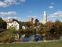 Downtown across the Blackstone River | |
| Motto(s): Rhode Island's Creative Community[1] | |
 Location in Providence County and the state of Rhode Island. | |
| Coordinates: 41°52′33″N 71°22′37″W / 41.87583°N 71.37694°W | |
| Country | United States |
| State | Rhode Island |
| County | Providence |
| Founded (town) | 1671 |
| Incorporated (city) | 1886 |
| Government | |
| • Type | Mayor-council |
| • Mayor | Donald R. Grebien (D) |
| • City Council |
Michael A. Araujo (D) Albert J. Vitali (D) Lorenzo C. Tetreault (D) David P. Moran (D) Mark J. Wildenhain (D) Terrence E. Mercer (D) John J. Barry, III (D) Meghan Kallman (D) Timothy P. Rudd, Jr. (D) |
| Area | |
| • Total | 9.00 sq mi (23.31 km2) |
| • Land | 8.7 sq mi (22.6 km2) |
| • Water | 0.3 sq mi (0.7 km2) |
| Elevation | 36 ft (11 m) |
| Population (2010) | |
| • Total | 71,148 |
| • Density | 8,177.9/sq mi (3,148.1/km2) |
| Time zone | UTC−5 (Eastern) |
| • Summer (DST) | UTC−4 (Eastern) |
| ZIP code | 02860–02862 |
| Area code(s) | 401 |
| FIPS code | 44-54640[2] |
| GNIS feature ID | 1218926[3] |
| Website |
www |
Pawtucket /pəˈtʌkɪt/ (![]()
Pawtucket borders Providence, Central Falls, North Providence, Lincoln, and East Providence in Rhode Island and Seekonk and Attleboro in the state of Massachusetts.
Name
The name "Pawtucket" comes from the Algonquian word for "river fall."[4]
History
The Pawtucket region was said to have been one of the most populous places in New England prior to the arrival of European settlers.[5] Native Americans would gather here to take advantage of the salmon and smaller fish which gathered at the falls.[5] The first European settler here was Joseph Jenckes, who came to the region from Lynn, Massachusetts.[5] He purchased about 60 acres near Pawtucket Falls in 1671.[5] He established a sawmill and forge.[5] These, along with the entire town, were later destroyed during King Philip's War.[5]
Other settlers followed Jencks, and by 1775 the area was home to manufacturers of muskets, linseed oil, potash, and ship building.[5] Also around this time Oziel Wilkinson and his family set up an iron forge making anchors, nails, screws, farm implements, and even cannons.[5]
Pawtucket was an early and important center of cotton textiles during the American Industrial Revolution. Slater Mill, built in 1793 by Samuel Slater on the Blackstone River falls in downtown Pawtucket, was the first fully mechanized cotton-spinning mill in America.[6] Slater Mill is known for developing a commercially successful production process not reliant on earlier horse-drawn processes developed in America. Slater constructed and operated machines for producing yarn. Other manufacturers continued, transforming Pawtucket into a center for textiles, iron working, and other products.
By the 1920s, Pawtucket was a prosperous mill town. The city boasted over a half-dozen movie theatres, two dozen hotels, and an impressive collection of fine commercial and residential architecture.[7] Perhaps the most impressive public building in Pawtucket was the Leroy Theatre, an ornate movie palace that was called "Pawtucket's Million Dollar Theater".[7] Many wealthy mill owners such as Darius Goff built their mansions in the area.[8]
The textile business in New England declined during the Great Depression with many manufacturers closing or moving their facilities South where operations and labor were cheaper. Later in the 20th Century, Pawtucket had begun to lose some of its architectural heritage to the wrecking ball, including the Leroy Theatre.[7]
But unlike numerous older mill towns in the region, Pawtucket retained much of its industrial base. Today, goods produced in the city include lace, non-woven and elastic woven materials, jewelry, silverware, metals, and textiles. Hasbro, one of the world's largest manufacturers of toys and games, is headquartered in Pawtucket.
 Jencks House
 Map of Pawtucket, Massachusetts, July 1848
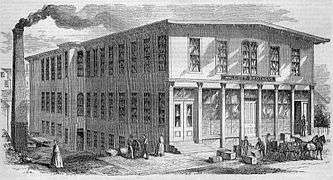 Walcott Brothers' factory in 1855
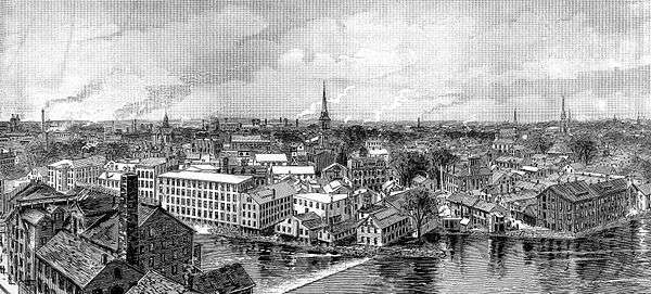 Pawtucket in 1886 viewed from the steeple of the Pawtucket Congregational Church
A Tale of Two States
Originally, the land west of the Blackstone River was part of nearby North Providence.[5] East of the Blackstone River was originally settled as part of the Massachusetts town of Rehoboth. The first Pawtucket to be incorporated was in 1828 when Rehoboth gave up their land and Pawtucket became a new town in Massachusetts. [5] In 1862 the eastern portion was absorbed into Providence County, Rhode Island.[5] On March 1, 1862 after a nearly 225 year border dispute between Rhode Island and Plymouth/Massachusetts, the areas of Pawtucket and East Providence was shifted into Rhode Island. The border hasnt been moved in over 150 years. In 1874, the land west of the river was taken from North Providence and added to the town of Pawtucket, but acted as two different towns. Finally in 1886, West and East Pawtucket were merged and the city was incorporated.[5][9]
Geography
Pawtucket is located at 41°52′32″N 71°22′34″W / 41.87556°N 71.37611°WCoordinates: 41°52′32″N 71°22′34″W / 41.87556°N 71.37611°W.[10]
According to the United States Census Bureau, the city has a total area of 9.0 square miles (23 km2), of which, 8.7 square miles (23 km2) of it is land and 0.3 square miles (0.78 km2) of it (2.89%) is water. Pawtucket lies within three drainage basins. These include the Blackstone River (including the Seekonk River), the Moshassuck River and the Ten Mile River.
Demographics
| Historical population | |||
|---|---|---|---|
| Census | Pop. | %± | |
| 1830 | 1,459 | — | |
| 1840 | 2,184 | 49.7% | |
| 1850 | 3,753 | 71.8% | |
| 1860 | 4,200 | 11.9% | |
| 1870 | 6,619 | 57.6% | |
| 1880 | 19,030 | 187.5% | |
| 1890 | 27,633 | 45.2% | |
| 1900 | 39,231 | 42.0% | |
| 1910 | 51,622 | 31.6% | |
| 1920 | 64,248 | 24.5% | |
| 1930 | 77,149 | 20.1% | |
| 1940 | 75,797 | −1.8% | |
| 1950 | 81,436 | 7.4% | |
| 1960 | 81,001 | −0.5% | |
| 1970 | 76,984 | −5.0% | |
| 1980 | 71,204 | −7.5% | |
| 1990 | 72,644 | 2.0% | |
| 2000 | 72,958 | 0.4% | |
| 2010 | 71,148 | −2.5% | |
| Est. 2017 | 72,001 | [11] | 1.2% |
| U.S. Decennial Census | |||
As of the census[2] of 2010, there were 71,141 people, 32,055 households, and 18,508 families residing in the city. Pawtucket was the fourth most populous of Rhode Island's 39 cities and towns. The population density was 8,351.2 people per square mile (3,223.0/km²). There were 32,055 housing units at an average density of 3,642.2 per square mile (1,405.7/km²). The racial makeup of the city was 59.5% Non-Hispanic white, 20.4% Non-Hispanic African American, 0.60% Native American, 1.5% Non-Hispanic Asian, 0.10% Pacific Islander, 6.1% from two or more races. Hispanic or Latino of any race were 19.7% of the population.
There were 32,055 households out of which 30.5% had children under the age of 18 living with them, 39.7% were married couples living together, 16.8% had a female householder with no husband present, and 38.4% were non-families. 32.3% of all households were made up of individuals and 12.5% had someone living alone who was 65 years of age or older. The average household size was 2.41 and the average family size was 3.07.
In the city, the population was spread out with 24.9% under the age of 18, 9.1% from 18 to 24, 31.3% from 25 to 44, 19.9% from 45 to 64, and 14.8% who were 65 years of age or older. The median age was 35 years. For every 100 females, there were 90.2 males. For every 100 females age 18 and over, there were 85.9 males.
The median income for a household in the city was $28,124, and the median income for a family was $40,578. Males had a median income of $31,129 versus $23,391 for females. The per capita income for the city was $17,008. About 14.9% of families and 16.8% of the population were below the poverty line, including 24.5% of those under age 18 and 15.2% of those age 65 or over.
According to the 2000 census, 20.6% of Pawtucket residents are French or French-Canadian.[12] Like nearby cities Providence, R.I., Fall River, Mass., and New Bedford, Mass., Pawtucket hosts a significant population from across the former Portuguese Empire (11.6%)[12] plus an extremely significant Cape Verdean population. The segment from Cape Verde Islands was featured in this Zip Code USA article from National Geographic magazine.
Pawtucket is also one of the few areas of the United States with a significant Liberian population, mostly refugees from Charles Taylor's regime. Rhode Island has the highest per capita Liberian population in the country. Pawtucket has a very high concentration of West Africans.
Arts and culture
The City of Pawtucket has been supportive of the Arts Community since 1975, In 1998, the Rhode Island General Assembly passed a law creating a 307-acre Arts and Entertainment District in the City’s historic downtown . Over the past decades various organizations have been active in continuing that support of the local arts community and beyond.
In January, 1999, Herb Weiss, of the Planning Department, was hired to oversee the City’s newly created Arts District. Through the support of then Mayor James E. Doyle and Planning Department Michael Cassidy, Weiss brought significant recognition for Pawtucket-Arts oriented development strategy . Mayor Doyle and Arts Czar Weiss hired researcher Ann Galligan, of Northeastern University, to create an arts and cultural plan. Over the years Pawtucket has become known as a center for arts and culture .
The success of the works was seen in nationwide publicity in publications such as New York Times , The Wall Street Journal , Christen Scientist Monitor . Pawtucket even found itself named in Art Calendar’s “Ten Great Towns for Working Arts.”Pawtucket’s transformation into an arts community is chronicled in a 53 minute documentary in 2008, Pawtucket Rising, produced by Jason Caminiti, a Fall River film maker, documenting the City’s successful efforts in bringing artist and cultural activities to blighted areas Pawtucket Rising.
Each September, the city, in conjunction with the Pawtucket Arts Festival Board of Directors, members chosen from the community, produce an annual citywide Arts Festival . Former Mayor Doyle created the City’s month-long event. Much of the work implementing the vision of Mayor Doyle and growing this month-long Arts Festival was done by Herb Weiss. Weiss, among other awards, was honored as the inaugural winner of the “PAF Excellence Award” for his work as the "foremost ambassador for the arts and culture". James Doyle was the Pawtucket Foundation Heritage Award Winner for 2011
The American-French Genealogical Society was founded in Pawtucket in 1978.[13]
On September 2, 1977, The Beach Boys performed a concert at Narragansett Park that was attended by 40,000 people, the largest concert audience in Rhode Island history. In 2017, music historians Al Gomes and Connie Watrous of Big Noise were successful in getting the street where the concert stage stood (the corner of 455 Narragansett Park Drive) officially renamed as "Beach Boys Way".[14][15] [16]
Sports
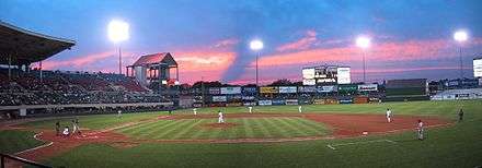
Pawtucket is home to McCoy Stadium, where the Pawtucket Red Sox, the AAA affiliate/Minor League team of the Boston Red Sox, currently play. The team was owned by Ben Mondor until his death and was recently sold by his estate. The longest professional baseball game in history, 33 innings, was played at McCoy Stadium in 1981.[17] Pawtucket has a history of professional baseball dating back to 1892, including the Pawtucket Indians. This rich and popular tradition will come to an end in 2021 when the Red Sox AAA affiliate is relocated to Worcester, Massachusetts[18]
In 1934 the Narragansett Park opened for Thoroughbred horse racing. Until its closure in 1978, the track hosted several important races that drew some of the top horses from around the United States including Hall of Fame members; Seabiscuit, War Admiral and Gun Bow.
Parks and recreation
- Slater Memorial Park has full recreational facilities including tennis courts and picnic areas.
- Daggett Farm
- Water Color Gallery open to the public for viewing
- Daggett House
- Marconi Garden
Education
Public schools
Public education in Pawtucket is directed by the Pawtucket School Department and contains these schools:[19]
Senior high schools
- William E. Tolman
- Charles E. Shea
- Jacqueline M. Walsh School for the Performing & Visual Arts
- Blackstone Academy Charter School
Junior high schools
- Samuel Slater
- Joseph Jenks
- Lyman B. Goff
Elementary schools
- Elizabeth Baldwin
- M. Virginia Cunningham
- Flora S. Curtis
- Curvin McCabe
- Fallon Memorial
- Nathanael Greene
- Agnes E. Little
- Potter Burns
- Francis J. Varieur
- Henry J. Winters
Catholic schools
The Quality Hill section of Pawtucket is home to St. Raphael Academy. It is a private college preparatory school founded on the basis of St. John the Baptist de la Salle. "Saints" is a small school consisting of roughly 500 students with a student to teacher ratio of about 15:2. The "Saints and Lady Saints" are very successful in sports including baseball, football, basketball, and softball. St. Raphael Academy is a rival of William E. Tolman. They took part in a Thanksgiving Day football game that was played in McCoy Stadium for over 70 years. This game is no longer played, as William E. Tolman now competes annually against its fellow Pawtucket public high school Charles E. Shea, rather than against St. Raphael Academy, a private Catholic high school.
Pawtucket used to be home ome to Bishop Keough High School, a small all-girls catholic high school located in the Fairlawn neighborhood that is now closed.
The city also has three Catholic elementary schools: St. Cecilia School, St. Teresa School and Woodlawn Catholic Regional School.
Infrastructure
Transportation
Amtrak's Northeast Corridor and the MBTA's Providence/Stoughton Line run through Pawtucket, though there is no stop for either in the city. Train service at the Pawtucket/Central Falls train station terminated in 1959. Recently there have been discussions to have the "T" stop in Pawtucket at the old train station (which would be substantially refurbished) or at a platform elsewhere on the line. Federal funding has been provided for preliminary planning of a MBTA station in the city, with a request for proposals expected in early 2011.[20] Commuters can currently board MBTA trains at the South Attleboro stop, located off Newport Avenue just over the state line. The MBTA operates a layover facility in Pawtucket for trains on the Providence/Stoughton Line where the trains are kept overnight. The closest Amtrak station to Pawtucket is Providence Station.
Public bus transportation is available in the city. RIPTA operates a hub in downtown Pawtucket with routes to various parts of the city and to parts of nearby towns. Riders can also access RIPTA buses to Providence at the downtown hub on the Smithfield Avenue (#53) and Beverage Hill (#78) routes; as well as on either the R-Line (Broad-North Main) Rapid Service route or #1 (Hope/Eddy) Key Corridor route. The # 1 (Hope/Eddy) Key Corridor route provides service from the Downtown Pawtucket hub north to the MBTA Station at South Attleboro, Mass. and south to T.F. Green Airport in Warwick. At Kennedy Plaza, Providence's hub, riders can access routes to most parts of the state.
Highways and roads
Interstate 95 and U.S. 1 also traverse the western part of Pawtucket. Some of the slowest posted speeds on I-95 are in the city due to the "S-curves" near downtown. In order to preserve certain buildings in the city, planners snaked I-95, creating sharp bends in the highway.
Downtown Circulator
Pawtucket's Downtown Circulator was a one-way loop through downtown; it is similar to British concepts of ring roads. A similar concept was also tried in Providence.
The circulator used East Avenue, High Street, Summer Street, Goff Avenue, Dexter Street and Park Place West. Each half of the Circulator carried one direction of U.S. 1; sections also carried westbound RI 15 and northbound RI 114. It was signed with a big "C" on overhead signs.
The circulator is no longer signed, though the road configuration remains. Providence's Downtown Ring Roads have suffered a similar fate.
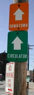 The only remaining sign
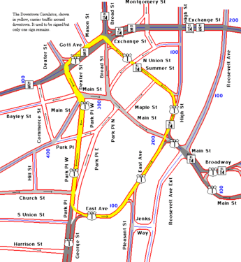 Map
Map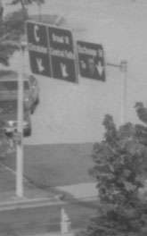 Former overhead signs, with C sign at left
Economy
Hasbro, a Fortune 1000 toy and game making company, is headquartered in Pawtucket.[21]
Many Healthcare, Retail and Insurance companies are headquartered in Pawtucket. [22]
Fox Point Pickles, a pickling company, is headquartered in Pawtucket.
Notable people
In popular culture
- In the 1999 film Outside Providence, the movie's main character, Tim Dunphy, grew up in Pawtucket. Many different Pawtucket locations are seen in the movie, including the police station.
- American Buffalo, a 1996 film, was filmed in Pawtucket.
- Pawtucket has been frequently referenced in the cartoon series Family Guy, specifically the "Pawtucket Brewery", Peter Griffin's place of work from Season 4 onwards, the character "Pawtucket Pat" and the beer "Pawtucket Patriot", though no brewery existed in the real Pawtucket when the show first made references to them. The toy company that Peter Griffin worked for early in the series was called the Happy-Go-Lucky Toy Co, the name a loose parody based on the name of the Hasbro toy company based in Pawtucket. In general, there is a strong argument that Pawtucket is the basis for the town of Quahog on the show.
- In December 1993, a character on the NBC sitcom Nurses called Pawtucket a pit. Then-mayor Bob Metivier appeared on the show months later in a cameo looking for an apology.
- The swimming pool at Tolman High School was used for the 1990 movie Mermaids.
Sister town

- Belper was where Samuel Slater had been apprenticed to Jedediah Strutt, learning the secrets of Richard Arkwright's Water Frame (and is sometimes known in that area as "Slater the traitor").[23]
References
- ↑ "City of Pawtucket, Rhode Island". City of Pawtucket, Rhode Island. Retrieved August 25, 2012.
- 1 2 "American FactFinder". United States Census Bureau. Archived from the original on September 11, 2013. Retrieved 2008-01-31.
- ↑ "US Board on Geographic Names". United States Geological Survey. 2007-10-25. Retrieved 2008-01-31.
- ↑ "Profile for Pawtucket, Rhode Island, RI". ePodunk. Retrieved August 24, 2012.
- 1 2 3 4 5 6 7 8 9 10 11 12 Greene, Welcome Arnold (1886). The Providence Plantations for 250 Years. Providence, RI: J.A. & R.A. Reid. pp. 375–379.
- ↑ "Blackstone River Valley National Heritage Corridor – History & Culture". U.S. National Park Service. Retrieved January 15, 2015.
- 1 2 3 "The Leroy Theatre, RIP". Providence, RI: The Providence Journal-Bulletin. 14 September 1997. p. D6.
- ↑ Grieve, Robert (1897). Illustrated History of Pawtucket, Central Falls and Vicinity. Providence: Henry R. Caufield. pp. 324–326.
- ↑ "Pawtucket, Rhode Island". City-Data.com. Retrieved August 24, 2012.
- ↑ "US Gazetteer files: 2010, 2000, and 1990". United States Census Bureau. 2011-02-12. Retrieved 2011-04-23.
- ↑ "Population and Housing Unit Estimates". Retrieved June 9, 2017.
- 1 2 Archived May 29, 2008, at the Wayback Machine.
- ↑ "American-French Genealogical Society: Home Page". Retrieved January 15, 2015.
- ↑ "YouTube : The Beach Boys RI Concert Commemoration". August 9, 2017.
- ↑ Smith, Andy (August 8, 2017). "In '77 Beach Boys Headlined R.I.'s Largest Concert". The Providence Journal.
- ↑ Markgraf, Diandra (September 5, 2017). "Pawtucket celebrates Beach Boys Way". The Valley Breeze.
- ↑ "The Longest Game in Baseball History". Pawsox.com. Retrieved 18 April 2015.
- ↑ Boston Globe. Aug 17, 2018, The Sox Moving Top Farm Team From Pawtucket to Worcester
- ↑ "Pawtucket School Department District Homepage". Retrieved August 19, 2008.
- ↑ Archived October 20, 2011, at the Wayback Machine.
- ↑ "Hasbro on the Forbes Just Companies List". Forbes. Retrieved 2018-01-19.
- ↑ "Large Employers in Pawtucket List". Labor Market Information. Retrieved 2018-03-28.
- ↑ "Belper Town Guide 2009–2011" (PDF). Belper Town Council. 2009. p. 12. Retrieved March 11, 2011.
External links
| Wikimedia Commons has media related to Pawtucket, Rhode Island. |

- Official website

- Pawtucket, Rhode Island at Curlie (based on DMOZ)
Municipalities and communities of Providence County, Rhode Island, United States | ||
|---|---|---|
| Cities | 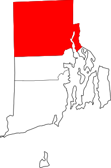 | |
| Towns | ||
| CDPs | ||
| Other villages | ||
Providence (capital) | |
| Topics |
|
| Society |
|
| Regions | |
| Cities | |
| Towns |
|
| Topics | |||||||
|---|---|---|---|---|---|---|---|
| States | |||||||
| Major cities | |||||||
| State capitals | |||||||
| Transportation |
| ||||||
| |||||||