Sandwich, New Hampshire
| Sandwich, New Hampshire | |
|---|---|
| Town | |
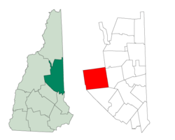 Location in Carroll County, New Hampshire | |
| Coordinates: 43°47′27″N 71°24′40″W / 43.79083°N 71.41111°WCoordinates: 43°47′27″N 71°24′40″W / 43.79083°N 71.41111°W | |
| Country | United States |
| State | New Hampshire |
| County | Carroll |
| Incorporated | 1763 |
| Villages |
Center Sandwich North Sandwich Sandwich Whiteface |
| Government | |
| • Board of selectmen |
Robert Rowan Christopher Boldt Willard (Bud) Martin |
| Area | |
| • Total | 93.5 sq mi (242.1 km2) |
| • Land | 90.2 sq mi (233.7 km2) |
| • Water | 3.2 sq mi (8.4 km2) 3.47% |
| Elevation | 797 ft (243 m) |
| Population (2010) | |
| • Total | 1,326 |
| • Density | 14/sq mi (5.5/km2) |
| Time zone | UTC-5 (Eastern) |
| • Summer (DST) | UTC-4 (Eastern) |
| ZIP code | 03227 |
| Area code(s) | 603 |
| FIPS code | 33-67780 |
| GNIS feature ID | 0873717 |
| Website |
sandwichnh |
Sandwich is a town in Carroll County, New Hampshire, United States. Its population was 1,326 at the 2010 census.[1] Sandwich includes the villages of Center Sandwich and North Sandwich. Part of the White Mountain National Forest is in the north, and part of Squam Lake is in the southwestern corner of the town.
History
Chartered in 1763 by Colonial Governor Benning Wentworth, the land was considered so inaccessible that the grant was enlarged, making Sandwich one of the largest towns in the state. It was named in honor of John Montagu, 4th Earl of Sandwich, said to be the inventor of the sandwich.
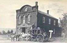
The earliest European settlers arrived in 1767. By 1830 Sandwich had grown to a population of 2700, roughly double the current (2010) population. At that time the town contained farms, stores, mills, churches, schools, carpenters, blacksmiths, and wheelwrights.
By the end of the 1800s much of the population had left Sandwich to live in cities to the west. Sandwich began to be an attraction for visitors, summer residents and artists, which continues to this day.[2]
The League of New Hampshire Craftsmen began in Sandwich as "Sandwich Home Industries" in 1920, and continues statewide today. Each fall the town hosts the Sandwich Fair. The Durgin Bridge, built in 1864, is a covered bridge in the eastern section of town.
Geography
According to the United States Census Bureau, the town has a total area of 93.5 square miles (242 km2), of which 90.2 square miles (234 km2) is land and 3.2 square miles (8.3 km2) is water, comprising 3.47% of the town.[3] Sandwich is drained to the east by the Bearcamp and Cold rivers, to the northwest by the Beebe River, to the southwest by Squam Lake, and to the south by the Red Hill River. Mount Israel, elevation 2,630 feet (802 m) above sea level, is at the center. Part of the Squam Mountains is in the west. Part of the Sandwich Range is in the north, including the 3,993-foot (1,217 m) Sandwich Mountain (also known as Sandwich Dome), the highest point in town.
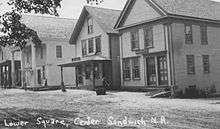
The primary settlement in the town is Center Sandwich. Other villages include Sandwich, North Sandwich, and Whiteface.
In popular culture
Many scenes from the iconic opening credits of the TV series Newhart were filmed in the Sandwich and Squam Lake area. The footage used for the series was leftover stock recorded for the film On Golden Pond which was also filmed in the area.
Demographics
| Historical population | |||
|---|---|---|---|
| Census | Pop. | %± | |
| 1790 | 905 | — | |
| 1800 | 1,413 | 56.1% | |
| 1810 | 2,232 | 58.0% | |
| 1820 | 2,368 | 6.1% | |
| 1830 | 2,743 | 15.8% | |
| 1840 | 2,625 | −4.3% | |
| 1850 | 2,577 | −1.8% | |
| 1860 | 2,227 | −13.6% | |
| 1870 | 1,854 | −16.7% | |
| 1880 | 1,701 | −8.3% | |
| 1890 | 1,303 | −23.4% | |
| 1900 | 1,077 | −17.3% | |
| 1910 | 928 | −13.8% | |
| 1920 | 1,175 | 26.6% | |
| 1930 | 731 | −37.8% | |
| 1940 | 742 | 1.5% | |
| 1950 | 615 | −17.1% | |
| 1960 | 620 | 0.8% | |
| 1970 | 666 | 7.4% | |
| 1980 | 905 | 35.9% | |
| 1990 | 1,066 | 17.8% | |
| 2000 | 1,286 | 20.6% | |
| 2010 | 1,326 | 3.1% | |
| Est. 2015 | 1,310 | [4] | −1.2% |
| U.S. Decennial Census[5] | |||

As of the census of 2010, there were 1,326 people, 617 households, and 405 families residing in the town. There were 1,057 housing units, of which 440, or 41.6%, were vacant. 373 of the vacant units were for seasonal or recreational use. The racial makeup of the town was 98.0% white, 0.2% African American, 0.2% Native American, 0.5% Asian, 0.1% Native Hawaiian or Pacific Islander, 0.0% some other race, and 1.1% from two or more races. 0.5% of the population were Hispanic or Latino of any race.[6]
Of the 617 households, 19.3% had children under the age of 18 living with them, 55.1% were headed by married couples living together, 7.9% had a female householder with no husband present, and 34.4% were non-families. 27.4% of all households were made up of individuals, and 13.9% were someone living alone who was 65 years of age or older. The average household size was 2.15, and the average family size was 2.59.[6]
In the town, 16.3% of the population were under the age of 18, 3.8% were from 18 to 24, 15.9% from 25 to 44, 40.9% from 45 to 64, and 23.2% were 65 years of age or older. The median age was 53.2 years. For every 100 females, there were 96.4 males. For every 100 females age 18 and over, there were 93.7 males.[6]
For the period 2011-2015, the estimated median annual income for a household was $57,000, and the median income for a family was $63,824. Male full-time workers had a median income of $57,917 versus $40,804 for females. The per capita income for the town was $31,599. 10.0% of the population and 7.3% of families were below the poverty line. 22.3% of the population under the age of 18 and 5.3% of those 65 or older were living in poverty.[7]
Sites of interest
Notable people
- Dixi Crosby, surgeon and educator, born in the town
- Claude Rains, earned four Oscar nominations for supporting actor and portrayed Captain Renault in the film Casablanca; lived in Sandwich from 1956 until his death in March 1967
- "Long John" Wentworth, Illinois politician, former mayor of Chicago
- Norbert Wiener, the founder of cybernetics, summered at his cottage in Sandwich until his death in 1964. Wiener and his wife Margaret are buried in Sandwich.
See also
- Sandwich, Illinois, named after Sandwich, New Hampshire
References
- ↑ United States Census Bureau, American FactFinder, 2010 Census figures. Retrieved March 23, 2011.
- ↑ Lamb, Janina, Discover Sandwich New Hampshire, The Sandwich Business Group
- ↑ "Geographic Identifiers: 2010 Demographic Profile Data (G001) - Sandwich town, New Hampshire". U.S. Census Bureau American Factfinder. Retrieved November 7, 2011.
- ↑ "Annual Estimates of the Resident Population for Incorporated Places: April 1, 2010 to July 1, 2015". Archived from the original on June 2, 2016. Retrieved July 2, 2016.
- ↑ "Census of Population and Housing". Census.gov. Retrieved June 4, 2016.
- 1 2 3 "Profile of General Population and Housing Characteristics: 2010 Census Summary File 1 (DP-1): Sandwich town, Carroll County, New Hampshire". U.S. Census Bureau, American Factfinder. Retrieved October 26, 2017.
- ↑ "Selected Economic Characteristics: 2011-2015 American Community Survey 5-Year Estimates (DP03): Sandwich town, Carroll County, New Hampshire". U.S. Census Bureau, American Factfinder. Retrieved October 26, 2017.
External links
- Town of Sandwich official website
- Sandwich Historical Society
- New Hampshire Economic and Labor Market Information Bureau Profile
- Squam Lakes Association
Places adjacent to Sandwich, New Hampshire | |
|---|---|
Municipalities and communities of Carroll County, New Hampshire, United States | ||
|---|---|---|
| Towns | 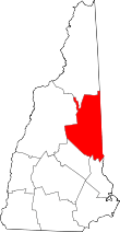 | |
| Township | ||
| CDPs | ||
| Other villages | ||