Watertown, Massachusetts
| Watertown, Massachusetts | ||
|---|---|---|
| City | ||
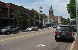 Watertown's Main Street | ||
| ||
|
Motto(s): In pace condita (Latin) "Founded in peace" | ||
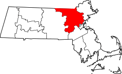
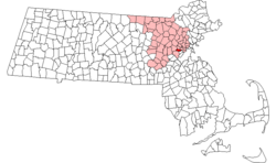 Location in Middlesex County in Massachusetts | ||
 Watertown, Massachusetts Location in the United States | ||
| Coordinates: 42°22′15″N 71°11′00″W / 42.37083°N 71.18333°WCoordinates: 42°22′15″N 71°11′00″W / 42.37083°N 71.18333°W | ||
| Country | United States | |
| State | Massachusetts | |
| County | Middlesex | |
| Settled | July 1630 | |
| Incorporated | September 7, 1630 | |
| Government | ||
| • Type | Council-manager | |
| • City Manager | Michael J. Driscoll | |
| Area | ||
| • Total | 4.2 sq mi (10.8 km2) | |
| • Land | 4.1 sq mi (10.6 km2) | |
| • Water | 0.1 sq mi (0.1 km2) | |
| Elevation | 36 ft (11 m) | |
| Population (2010) | ||
| • Total | 31,915 | |
| • Estimate (2016)[1] | 35,025 | |
| • Density | 7,600/sq mi (3,000/km2) | |
| Time zone | UTC−5 (Eastern) | |
| • Summer (DST) | UTC−4 (Eastern) | |
| ZIP code | 02472 | |
| Area code(s) | 617 / 857 | |
| FIPS code | 25-73440 | |
| GNIS feature ID | 0612401 | |
| Website | http://www.ci.watertown.ma.us/ | |
The Town of Watertown is a city in Middlesex County, Massachusetts, United States. It is part of the Greater Boston area. The population was 31,915 at the 2010 census. Watertown is one of thirteen Massachusetts municipalities that have applied for, and been granted, city forms of government but wish to retain "The town of" in their official names.[2]
Watertown is made up of six neighborhoods: Bemis, Brigham (Brigham Historic District), Coolidge Square, East Watertown, Watertown Square and the West End.
History
Archeological evidence suggests that Watertown was inhabited for thousands of years before the arrival of settlers from England. Two tribes of Massachusett, the Pequossette and the Nonantum, had settlements on the banks of the river later called the Charles.[3] The Pequossette built a fishing weir to trap herring at the site of the current Watertown Dam. The annual fish migration, as both alewife and blueback herring swim upstream from their adult home in the sea to spawn in the fresh water where they were hatched, still occurs every spring.[4]
Watertown, first known to settlers as Saltonstall Plantation, was one of the earliest of the Massachusetts Bay Colony settlements. Founded in early 1630 by a group of settlers led by Richard Saltonstall and George Phillips, it was officially incorporated that same year. The alternate spelling "Waterton" is seen in some early documents.[5]
The first buildings were upon land now included within the limits of Cambridge known as Gerry's Landing. For its first quarter century Watertown ranked next to Boston in population and area. Since then its limits have been greatly reduced. Thrice portions have been added to Cambridge, and it has contributed territory to form the new towns of Weston (1712), Waltham (1738), Lincoln (1754) and Belmont (1859). In 1632 the residents of Watertown protested against being compelled to pay a tax for the erection of a stockade fort at Cambridge; this was the first protest in America against taxation without representation and led to the establishment of representative democracy in the colony.[6] As early as the close of the 17th century, Watertown was the chief horse and cattle market in New England and was known for its fertile gardens and fine estates. Here about 1632 was erected the first gristmill in the colony, and in 1662 one of the first woolen mills in America was built here.

Revolutionary War era
Much excitement was generated in Watertown towards the start of the American Revolutionary War period. In 1773, many of its citizens were engaged with the Sons of Liberty in another tax protest, this time against the British Tea Tax which resulted in the famous Boston Tea Party rebellion.[7]
Then later (April 1775), some 134 Watertown minutemen responded to the alarm from Lexington to rout the British redcoats from their march to Concord. Thereafter many of these citizen soldiers were part of the first battle line formed at the Siege of Boston. Another Watertown citizen, Israel Bissel, was the first rider to take the news of the British attack and rode all the way to Connecticut, New York and Philadelphia.[8][9][10]
The Massachusetts Provincial Congress, after adjournment from Concord, met from April to July 1775 in the First Parish Church, the site of which is marked by a monument. The Massachusetts General Court held its sessions here from 1775 to 1778. Committees met in the nearby Edmund Fowle House. Boston town meetings were held here during the siege of Boston, when many Boston families made their homes in the neighborhood. For several months early in the American Revolution the committees of safety and committee of correspondence made Watertown their headquarters and it was from here that General Joseph Warren set out for Bunker Hill.[11]
Here, the Treaty of Watertown, the first treaty signed between the newly formed United States of America and a foreign power, the St. John's and Mi'kmaq First Nations of Nova Scotia, was signed in this house.[12][13]
Industrial era
From 1832 to 1834 Theodore Parker conducted a private school here and his name is still preserved in the Parker School, though the building no longer operates as a public school.
The Watertown Arsenal operated continuously as a military munitions and research facility from 1816 until 1995, when the Army sold the property, by then known as the Army Materials Technology Laboratory,[14] to the town of Watertown. The Arsenal is notable for being the site of a 1911 strike prompted by the management methods of operations research pioneer Frederick Winslow Taylor (Taylor and 1911 Watertown Arsenal Strike). Taylor's method, which he dubbed "Scientific Management," broke tasks down into smaller components. Workers no longer completed whole items; instead, they were timed using stopwatches as they did small tasks repetitively, as Taylor attempted to find the balance of tasks that resulted in the maximum output from workers. The strike and its causes were controversial enough that they resulted in Congressional hearings in 1911; Congress passed a law in 1915 banning the method in government owned arsenals. Taylor's methods spread widely, influencing such industrialists as Henry Ford, and the idea is one of the underlying inspirations of the factory (assembly) line industrial method. The Watertown Arsenal was the site of a major superfund clean-up in the 1990s, and has now become a center for shopping, dining and the arts, with the opening of several restaurants and a new theatre. The site includes the Arsenal Center for the Arts, a regional arts center that opened in 2005. The Arsenal is now owned by athenahealth. Arsenal Street features two shopping malls across the street from one another, with the Watertown Mall on one side, and The Arsenal Project of Watertown (formerly the Arsenal Mall) on the other.
The Perkins School for the Blind, founded in 1829, has been located in Watertown since 1912.
The Stanley Brothers built the first of their steam-powered cars, which came to be known as Stanley Steamers, in Watertown in 1897.[15]
In 1988, Watertown Square became the new location for the Armenian Library and Museum of America, said to host the largest collection of Armenian artifacts in North America.
Shortly after midnight of April 18–19, 2013, the two suspects in the Boston Marathon bombing engaged in a protracted battle with police, in Watertown involving the use of firearms and explosives. Tamerlan Tsarnaev was critically wounded and later pronounced dead and the town was completely locked down for hours as police, FBI, and Army National Guard personnel patrolled it, looking for the remaining suspect, Dzhokhar Tsarnaev, who was captured wounded but alive in a boat shortly after the lockdown ended on the following evening.
Geography
Watertown is located at 42°22′17″N 71°10′55″W / 42.37139°N 71.18194°W (42.37139, −71.18194).[16] To the north, it is bordered by the town of Belmont, along Belmont Street; to the south, it is bordered by Newton and Brighton—the border being largely formed by the Charles River. In Watertown Square, the nexus of the town, the town's border extends south of the Charles to encompass the neighborhood surrounding Casey Playground. To the east lies the City of Cambridge, the border to which is almost entirely the well-known Mount Auburn Cemetery, most of which is actually in Watertown (though commonly believed to be in Cambridge). To the west lies the more expansive city of Waltham, but there is no distinct geographic feature dividing the two municipalities.
According to the United States Census Bureau, the city has a total area of 4.2 square miles (11 km2), of which 4.1 square miles (11 km2) is land and 0.1 square miles (0.1 km² or 1.20%) is water.
Adjacent cities and towns
Demographics
| Historical population | ||
|---|---|---|
| Year | Pop. | ±% |
| 1840 | 1,810 | — |
| 1850 | 2,837 | +56.7% |
| 1860 | 3,270 | +15.3% |
| 1870 | 4,326 | +32.3% |
| 1880 | 5,426 | +25.4% |
| 1890 | 7,073 | +30.4% |
| 1900 | 9,766 | +38.1% |
| 1910 | 12,875 | +31.8% |
| 1920 | 21,457 | +66.7% |
| 1930 | 34,913 | +62.7% |
| 1940 | 35,427 | +1.5% |
| 1950 | 37,329 | +5.4% |
| 1960 | 39,092 | +4.7% |
| 1970 | 39,307 | +0.5% |
| 1980 | 34,384 | −12.5% |
| 1990 | 33,284 | −3.2% |
| 2000 | 32,986 | −0.9% |
| 2010 | 31,915 | −3.2% |
| 2016 | 35,025 | +9.7% |
| * = population estimate. Source: United States Census records and Population Estimates Program data.[17][18][19][20][21][22][23][24][25][26] Source: | ||
As of the census[28] of 2000, there were 32,986 people, 14,629 households, and 7,329 families residing in the city. The population density was 8,025.7 people per square mile (3,098.8/km²). There were 15,008 housing units at an average density of 3,651.5 per square mile (1,409.9/km²). The racial makeup of the city was 91.42% White, 1.73% African American, 0.16% Native American, 3.87% Asian, 0.02% Pacific Islander, 0.85% from other races, and 1.95% from two or more races. Hispanic or Latino of any race were 2.68% of the population.
There were 14,629 households out of which 17.8% had children under the age of 18 living with them, 37.9% were married couples living together, 8.7% had a female householder with no husband present, and 49.9% were non-families. 34.1% of all households were made up of individuals and 12.4% had someone living alone who was 65 years of age or older. The average household size was 2.17 and the average family size was 2.86.
In the city, the population was spread out with 14.1% under the age of 18, 9.4% from 18 to 24, 39.8% from 25 to 44, 20.0% from 45 to 64, and 16.7% who were 65 years of age or older. The median age was 37 years. For every 100 females, there were 86.1 males. For every 100 females age 18 and over, there were 83.8 males.
The median income for a household in the city was $59,764, and the median income for a family was $67,441. Males had a median income of $46,642 versus $39,840 for females. The per capita income for the city was $33,262. About 4.5% of families and 6.3% of the population were below the poverty line, including 8.6% of those under age 18 and 7.5% of those age 65 or over.
Armenian population

Watertown is a major center of the Armenian diaspora in the United States, with the third-largest Armenian community in the United States, estimated as numbering 7,000[29] to over 8,000[30] as of 2007.[31] Watertown ranks only behind the California cities of Glendale and Fresno. Watertown is also the venue for the publication of long-running Armenian newspapers in English and Armenian, including:
- Baikar Association Inc.'s
- Hairenik Association Inc.'s
- Armenian Weekly
- Հայրենիք (Hairenik Weekly)
- Armenian Review
- Hairenik Association also runs a web radio and a web TV station.
.jpg)
Economy
Major employers based in Watertown include the Tufts Health Plan, New England Sports Network, the Perkins School for the Blind, Sasaki, Exergen Corporation,[32] Harvard Business Publishing, Bright Horizons Family Solutions and athenahealth.[33]
Transportation
Watertown borders Soldiers Field Road and the Massachusetts Turnpike, major arteries into downtown Boston. Watertown is served by several MBTA bus and trackless trolley routes. Most of them pass through or terminate in Watertown Square or Watertown Yard. The former A-Watertown branch of the MBTA's Green Line ran to Watertown until 1969.
Education
Watertown Public Schools operates public schools in the city.
Notable people

- Richard Bakalyan (1931–2015), actor[34]
- Seth Bemis (1775-1851), industrialist and entrepreneur
- Boston, Boston-based rock group led by Tom Scholz, recorded the majority of the (17x) Platinum eponymous album Boston at the Foxglove Studio in Watertown.
- Charles Brigham (1841–1925), nationally known architect and designer of the Watertown town seal
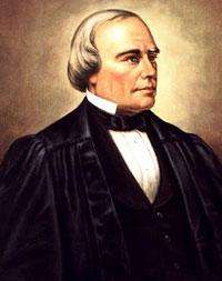
- Benjamin Robbins Curtis (1809–74), American jurist. Dissented in the Dred Scott case and defended Andrew Johnson during the president's impeachment trial.
- Frederick C. Crawford (1891–1994), American industrialist, founder of TRW and Crawford Auto-Aviation Museum
- Jeff DaRosa (1982–), Musician, member of Dropkick Murphys and former member of the Exit
- James DeMarco (1968–), artist and cartoonist
- Eliza Dushku (1980–), film and TV actress, grew up in Watertown and graduated from Watertown High School
- Convers Francis (1795–1863), minister ordained at the Watertown Unitarian Church, who, along with Ralph Waldo Emerson, Henry David Thoreau and others, had an important role in transcendentalism
- William Henry Goddard, Sr. (1627–1691), 1665 pioneer farmer and teacher, descendent of the Goddards of Wiltshire and progenitor of American line of Goddards which includes Robert Goddard (NASA Goddard Space Center), and President Calvin Coolidge, 30th POTUS
- Hrach Gregorian (1949–), PhD, grew up in Watertown, 1968 Watertown High School graduate. Faculty member at several universities, business executive, writer and teacher on international conflict management and post-conflict peace-building.
- Thomas Hastings (colonist) (c1605–1685), English immigrant ancestor of Rev. Theodore Parker, among others
- Charles Foster Hathaway, founder of C.F. Hathaway Company shirt company
- Harriet Hosmer (painter & sculptor), (1830-1908) known as the first female professional sculptor.
- Drastamat Kanayan, better known as Dro (Դրօ), was an Armenian military commander and politician, a member of the Armenian Revolutionary Federation. He served as Defense Minister of Armenia in 1920, during the country's brief independence. Dro died in Watertown on March 8, 1956 and was buried at Mount Auburn Cemetery.
- Hakob Karapents (1925-1994), Iranian-Armenian writer
- Helen Keller (1880–1968), attended the Perkins Institute for the Blind
- John Lawrence, VIII (1609–1667), early settler, carpenter. One source[35] gives his arrival date in Watertown as 1630, others[36] as 1635 or 1636.
- Thomas Mayhew, early settler and Governor of Martha's Vineyard, Nantucket and adjacent islands
- Stephen P. Mugar (1901–82), founder of Star Market, philanthropist
- Christopher Nowinski (1978–), former World Wrestling Entertainment wrestler (maintains a house here).
- John Oldham (1592–1636), early Puritan settler
- Charles Pratt (1830–91), wealthy oil industry pioneer and philanthropist
- Robert Seeley (1602–68), co-founder of Watertown, landowner
- Charles Sumner Tainter (1854–1940), inventor, associate and nephew of Alexander Graham Bell
- Steven Van Zandt (1950–), guitarist of Springsteen's E-Street Band, actor from The Sopranos, lived at 16 Edgecliff Road until the age of seven.
- Jerry York (1945–), Boston College men's head ice hockey coach
Politicians
- George Bachrach, State Senator representing Greater Boston Area; Democratic candidate for Governor in 1994 and 1998
- Rachel Kaprielian, former head of Massachusetts Registry of Motor Vehicles, and former state representative
- Nancy Masterton, Maine state representative
- Thomas Reilly, Massachusetts attorney general (1999–2007)
- Warren Tolman, Democratic candidate for Lt. Governor in 1998, Governor in 2002 and Attorney General in 2014
Sports
- At the close of 2016, the Watertown Raiders High School field hockey team has won 16 state championships from the 1980s up to the present. The team has won 8 consecutive state championships in 2009 through 2017. Watertown has 123 straight wins and had gone undefeated in 183 straight games.
- The Watertown High School Raiders won the Division III State Championship for basketball during the 2006–07, 2008–09, and 2017-18 seasons.
- Watertown Pop Warner football won back-to-back eastern Mass. state championships for division II in 2007 and 2008.
- Watertown youth hockey won the state championship for youth hockey division II in 2005–06.
- The Watertown High School Raiders soccer team won the MIAA Division III North title in 2012–13 and 2017-18.
- The Watertown High School Raiders football team won the MIAA Division III North title in 2017-18.
Culture
- Armenian Library and Museum of America at 65 Main Street in the former Coolidge Bank building
- Hairenik Association at 80 Bigelow Avenue
- Perkins Braille and Talking Book Library, on the campus of the Perkins School for the Blind
- Watertown Free Public Library[37] at 123 Main Street, in a newly renovated and expanded building
- New Repertory Theatre is the resident professional theatre company at the Arsenal Center for the Arts, 321 Arsenal Street
- The Plumbing Museum, located at 80 Rosedale Road in a former ice house next to the J.C. Cannistraro corporate offices
- The Edmund Fowle House (1772) and Museum, at 28 Marshall St., the second oldest surviving house in Watertown (after the Browne House)
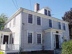
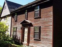
- The Abraham Browne House (built circa 1694–1701) is a colonial house located at 562 Main Street. It is now a nonprofit museum operated by Historic New England and open to the public two afternoons a year.
- Mount Auburn Cemetery, founded in 1831, consists of 151.1 acres of well manicured grounds with numerous species of both indigenous and exotic tree and shrub species. It is Watertown's largest contiguous open space and extends into Cambridge to the east. Parking is available for visitors.
- Gore Place is an early 19th-century historic house museum and National Historic Landmark in Waltham, Massachusetts, with 31.6 acres of the 45-acre estate located in Watertown.
- The Watertown Arsenal was a major American arsenal located on the northern shore of the Charles River in Watertown. Its site is now registered on the ASCE's List of Historic Civil Engineering Landmarks and on the U.S. National Register of Historic Places.
See also
References
- ↑ "Population and Housing Unit Estimates". Retrieved June 9, 2017.
- ↑ "CIS: Massachusetts City and Town Incorporation and Settlement Dates". www.sec.state.ma.us.
- ↑ "History & Tourism - Watertown, MA - Official Website". www.ci.watertown.ma.us.
- ↑ "Watertown Tab "Zubrowski: The herring run through Watertown from Mother's Day to Father's Day" (June 10, 2009)". Wicked Local. Retrieved 7 October 2014.
- ↑ Young, Alexander (1846). Chronicles of the First Planters of the Colony of Massachusetts Bay, 1623-1636, pp. 313-14. Boston: Charles C. Little and James Brown.
- ↑ Chisholm, Hugh (1911). The Encyclopædia Britannica: A Dictionary of Arts, Sciences, Literature and General Information. Encyclopædia Britannica Company. p. 411.
- ↑ "Watertown Tour". maintour.com.
- ↑ "Bissell Outrode Paul Revere But History Left Him in the Dust", Hartford Courant, April 16, 2007
- ↑ "Israel Bissell (1752-1823) - Find A Grave..." www.findagrave.com.
- ↑ "The Five Riders". www.constitutionfacts.com.
- ↑ Hodges, Maud deLeigh. 1980. Crossroads on the Charles. Phoenix Publishing, Canaan, NH
- ↑ Maine Historical Society. "Documentary history of the state of Maine ." Portland – via Internet Archive.
- ↑ Daniel N. Paul, We Were Not the Savages: A Mi'kmaq Perspective on the Collision between European and Native American Civilizations (2000), pp. 169-170 (includes full text of both treaties).
- ↑ John Pike. "History of the AMTL". Retrieved 7 October 2014.
- ↑ "1906 Stanley Steamer Rocket Images, Information and History". Conceptcarz.com. Retrieved 2013-01-19.
- ↑ "US Gazetteer files: 2010, 2000, and 1990". United States Census Bureau. 2011-02-12. Retrieved 2011-04-23.
- ↑ "Total Population (P1), 2010 Census Summary File 1". American FactFinder, All County Subdivisions within Massachusetts. United States Census Bureau. 2010.
- ↑ "Massachusetts by Place and County Subdivision - GCT-T1. Population Estimates". United States Census Bureau. Retrieved July 12, 2011.
- ↑ "1990 Census of Population, General Population Characteristics: Massachusetts" (PDF). US Census Bureau. December 1990. Table 76: General Characteristics of Persons, Households, and Families: 1990. 1990 CP-1-23. Retrieved July 12, 2011.
- ↑ "1980 Census of the Population, Number of Inhabitants: Massachusetts" (PDF). US Census Bureau. December 1981. Table 4. Populations of County Subdivisions: 1960 to 1980. PC80-1-A23. Retrieved July 12, 2011.
- ↑ "1950 Census of Population" (PDF). Bureau of the Census. 1952. Section 6, Pages 21-10 and 21-11, Massachusetts Table 6. Population of Counties by Minor Civil Divisions: 1930 to 1950. Retrieved July 12, 2011.
- ↑ "1920 Census of Population" (PDF). Bureau of the Census. Number of Inhabitants, by Counties and Minor Civil Divisions. Pages 21-5 through 21-7. Massachusetts Table 2. Population of Counties by Minor Civil Divisions: 1920, 1910, and 1920. Retrieved July 12, 2011.
- ↑ "1890 Census of the Population" (PDF). Department of the Interior, Census Office. Pages 179 through 182. Massachusetts Table 5. Population of States and Territories by Minor Civil Divisions: 1880 and 1890. Retrieved July 12, 2011.
- ↑ "1870 Census of the Population" (PDF). Department of the Interior, Census Office. 1872. Pages 217 through 220. Table IX. Population of Minor Civil Divisions, &c. Massachusetts. Retrieved July 12, 2011.
- ↑ "1860 Census" (PDF). Department of the Interior, Census Office. 1864. Pages 220 through 226. State of Massachusetts Table No. 3. Populations of Cities, Towns, &c. Retrieved July 12, 2011.
- ↑ "1850 Census" (PDF). Department of the Interior, Census Office. 1854. Pages 338 through 393. Populations of Cities, Towns, &c. Retrieved July 12, 2011.
- ↑ "Census of Population and Housing". Census.gov. Retrieved June 4, 2015.
- ↑ "American FactFinder". United States Census Bureau. Retrieved 2008-01-31.
- ↑ Armenians in Watertown, MA in Hayk the Ubiquitous Armenian
- ↑ Watertown in Armeniapedia.org
- ↑ Keith O'Brien, "ADL local leader fired on Armenian issue", The Boston Globe, August 18, 2007.
- ↑ "Changing The Way The World Takes Temperature". Exergen. Retrieved 28 November 2017.
- ↑ "Labor Market Information". Retrieved 2014-12-16.
- ↑ Watertown, Massachusetts on IMDb
- ↑ "Genealogy Report: Descendents of John Lawrence". Genealogy.com. Retrieved 30 January 2016.
- ↑ "John LAWRENCE, VIII". Geneal.net. 2002. Retrieved 28 January 2016.
- ↑ "Today at the WFPL". Retrieved 7 October 2014.
Further reading
- 1871 Atlas of Massachusetts. by Wall & Gray. Map of Massachusetts. Map of Middlesex County.
- History of Middlesex County, Massachusetts, Volume 1 (A-H), Volume 2 (L-W) compiled by Samuel Adams Drake, published 1879-1880.
- Watertown article by Francis S. Drake in volume 2, pages 433-460.
- An Historical Sketch of Watertown, in Massachusetts, by Convers Francis, published in 1830.
- Bond, Dr. Henry, Genealogies of Watertown, Massachusetts, Boston: Higginson Book Company (undated modern reprint of 1860 edition).
- Thompson, Roger, Divided We Stand, Watertown, Massachusetts 1630-1680, Amherst: University of Massachusetts Press, 2001.
- Tourtellot, Arthur B., The Charles (Rivers of America series), New York: Farrar & Rinehart, Inc., 1941.
- Fischer, David Hackett, Albion's Seed, Four British Folkways in America, New York: Oxford University Press, 1989.
External links
| Wikimedia Commons has media related to Watertown, Massachusetts. |
- Watertown official website
- Armenian Library and Museum of America
- Watertown Community Foundation
- Watertown History
- Watertown Art Association
- Watertown Free Public Library
- Watertown TAB & Press, Watertown's newspaper
- Zoomable view of Watertown circa 1879