North Kingstown, Rhode Island
| North Kingstown, Rhode Island | |
|---|---|
| Town | |
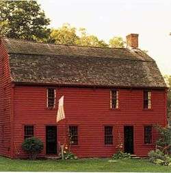 The Gilbert Stuart Birthplace in North Kingstown | |
| Nickname(s): "NK" | |
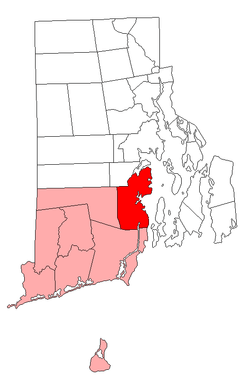 Location of North Kingstown in Washington County, Rhode Island | |
| Coordinates: 41°34′50″N 71°27′14″W / 41.58056°N 71.45389°WCoordinates: 41°34′50″N 71°27′14″W / 41.58056°N 71.45389°W | |
| Country | United States |
| State | Rhode Island |
| County | Washington |
| Government | |
| • Town Council |
Kerry P. McKay Carol H. Hueston Jason A. Alberquerque Kevin V. Maloney Ellen S. Waxman |
| Area | |
| • Total | 58.3 sq mi (151.1 km2) |
| • Land | 43.6 sq mi (112.9 km2) |
| • Water | 14.7 sq mi (38.2 km2) |
| Elevation | 82 ft (25 m) |
| Population (2015) | |
| • Total | 26,197 |
| • Density | 607.5/sq mi (234.6/km2) |
| Time zone | UTC−5 (Eastern (EST)) |
| • Summer (DST) | UTC−4 (EDT) |
| ZIP codes | 02852 (North Kingstown), 02874 (Saunderstown), 02877 (Slocum) |
| Area code(s) | 401 |
| FIPS code | 44-51580[1] |
| GNIS feature ID | 1220088[2] |
| Website | www.northkingstown.org |
North Kingstown is a town in Washington County, Rhode Island, United States, and is part of the Providence metropolitan area. According to the 2015 American Community Survey 5-Year Estimates, the population in 2015 was 22,358. North Kingstown is home to the birthplace of the famous American portraitist Gilbert Stuart who was born in the village of Saunderstown. Within the town is Quonset Point, location of the former Naval Air Station Quonset Point, known for the invention of the Quonset hut, as well as the neighborhood of Davisville, location of the former Davisville Naval Construction Battalion Center.
History
The town of Kings Towne was founded in 1674, by the colonial government, and included the present day towns of North Kingstown, South Kingstown, Exeter, and Narragansett. In 1722, Kings Towne was split into two parts, North Kingstown and South Kingstown, with North Kingstown, having the earliest settlements, retaining the 1674 establishment date. In 1742 the town of Exeter was taken from the western part of North Kingstown.
Geography
According to the United States Census Bureau, the town has a total area of 58.3 square miles (151 km2). 43.6 square miles (113 km2) of it is land and 14.8 square miles (38 km2) of it (25.28%) is water.
Demographics
| Historical population | |||
|---|---|---|---|
| Census | Pop. | %± | |
| 1790 | 2,907 | — | |
| 1800 | 2,794 | −3.9% | |
| 1810 | 2,957 | 5.8% | |
| 1820 | 3,007 | 1.7% | |
| 1830 | 3,036 | 1.0% | |
| 1840 | 2,909 | −4.2% | |
| 1850 | 2,971 | 2.1% | |
| 1860 | 3,104 | 4.5% | |
| 1870 | 3,563 | 14.8% | |
| 1880 | 3,949 | 10.8% | |
| 1890 | 4,193 | 6.2% | |
| 1900 | 4,194 | 0.0% | |
| 1910 | 4,048 | −3.5% | |
| 1920 | 3,397 | −16.1% | |
| 1930 | 4,279 | 26.0% | |
| 1940 | 4,604 | 7.6% | |
| 1950 | 14,180 | 208.0% | |
| 1960 | 18,977 | 33.8% | |
| 1970 | 29,793 | 57.0% | |
| 1980 | 21,938 | −26.4% | |
| 1990 | 23,786 | 8.4% | |
| 2000 | 26,326 | 10.7% | |
| 2010 | 26,486 | 0.6% | |
| Est. 2015 | 26,197 | [3] | −1.1% |
| U.S. Decennial Census[4][5] | |||

As of the census[1] of 2000, there were 26,326 people, 10,154 households, and 7,310 families residing in the town. The population density was 603.9 people per square mile (233.2/km²). There were 10,743 housing units at an average density of 246.4 per square mile (95.2/km²). The racial makeup of the town was 95.71% White, 0.97% African American, 0.55% Native American, 0.95% Asian, 0.03% Pacific Islander, 0.53% from other races, and 1.25% from two or more races. Hispanic or Latino of any race were 1.77% of the population.
There were 10,154 households out of which 35.7% had children under the age of 18 living with them, 40.6% were married couples living together, 46.5% had a female householder with no husband present, and 28.0% were non-families. 22.5% of all households were made up of individuals and 8.2% had someone living alone who was 65 years of age or older. The average household size was 2.57 and the average family size was 3.03.
In the town, the age distribution of the population shows 26.0% under the age of 18, 6.0% from 18 to 24, 29.6% from 25 to 44, 26.6% from 45 to 64, and 11.8% who were 65 years of age or older. The median age was 39 years. For every 100 females, there were 93.9 males. For every 100 females age 18 and over, there were 89.6 males.
The median income for a household in the town was $83,887 (adjusted to inflation), and the median income for a family was $97,208. Males had a median income of $28,883 versus $25,712 for females. The per capita income for the town was $39,324. About 18.8% of families and 16.1% of the population were below the poverty line, including 9.6% of those under age 18 and 4.8% of those age 65 or over.
Transportation
Wickford Junction is a terminus station on the Providence/Stoughton Commuter Rail Line, providing weekday service to Providence Station and Boston's South Station.
RIPTA also services in the town inbound to Providence and outbound to Narragansett or Newport
Notable people
- Gilbert Stuart (1755–1828), painter; his portrait of George Washington appears on the one dollar bill
- CJ Adams (2000–present), child star, in movie Odd Life of Timothy Green
- Elizabeth Beisel, 3× Olympic medalist swimmer
Points of interest
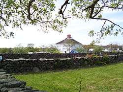
- Casey Farm (1725): An original colonial plantation that is today one of the oldest operational farms in New England.
- Davis Memorial Wildlife Refuge: 96 acres of forest and wetlands preserved by the Audubon Society of Rhode Island.
- Devil's Foot Rock: A footprint-like natural impression or possibly petrosomatoglyph. Legends going back to the colonial era tell of a Native American woman being chased by the devil. Some say that she fled from Boston. Her pursuer is said to have left his footprints at Devil's Foot Rock, then at Chimney Hill in South Kingstown, and finally at Block Island.
- Gilbert Stuart Birthplace and Museum (1751): The house in which American portraitist Gilbert Stuart was born in 1755. The museum features works from throughout Stuart's career and operational grist and snuff mills.
- Historic Wickford Village: A historic seaside village which contains one of the largest collections of preserved 18th-century houses in the Northeastern United States. Wickford also has a large and scenic harbor.
- David S. Baker Estate: Home of Rhode Island's first elected Governor to never be seated. Northeastern United States.
- Quonset Air Museum: A large museum located at the former Naval Air Station Quonset Point which focuses on military aviation history.
- Smith's Castle (1678): A colonial plantation located on the shore of Narragansett Bay.
- Quonset Point, a former military base which was once the home of the Naval Construction Battalions known as the Seabees
- John Cole (1715–1777), was a lawyer and 12th Chief Justice of the Rhode Island Supreme Court[6]
Other National Historic Places in North Kingstown
- Allen-Madison House (1801)
- Camp Endicott (1942)
- Crowfield Historic District
- Davisville Historic District
- George Douglas House (1738)
- George Fayerweather Blacksmith Shop (1819)
- Ezekial Gardner House
- Hamilton Mill Village Historic District
- Lafayette Village
- Stephen Northup House (1712)
- Old Narragansett Cemetery
- Old Narragansett Church (1707)
- Palmer-Northrup House (1680)
- Joseph Pierce Farm
- Plum Beach Light (1899)
- Poplar Point Light (1831)
- Rathbun House
- Esbon Sanford House (1832)
- Saunderstown Historic District
- Six Principle Baptist Church (1703)
- Joseph Slocum House (1750)
- Spink Farm (1798)
- St. Paul's Church (1847)
- The Taggart Home (1901)
- The Young House
- YWCA Site
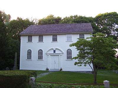 Old Narragansett Church, built in 1707, is the oldest Episcopal Church building in New England
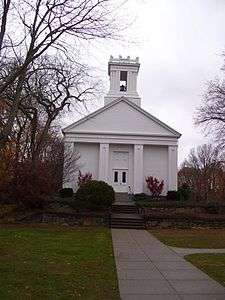 Baptist Church in Wickford
See also
References
- 1 2 "American FactFinder". United States Census Bureau. Retrieved 2008-01-31.
- ↑ "US Board on Geographic Names". United States Geological Survey. 2007-10-25. Retrieved 2008-01-31.
- ↑ "Annual Estimates of the Resident Population for Incorporated Places: April 1, 2010 to July 1, 2015". Archived from the original on June 2, 2016. Retrieved July 2, 2016.
- ↑ "Census of Population and Housing". Census.gov. Retrieved June 4, 2016.
- ↑ Snow, Edwin M. (1867). Report upon the Census of Rhode Island 1865. Providence, RI: Providence Press Company.
- ↑ Updike, Wilkins (1907). A history of the Episcopal Church in Narragansett, Rhode Island: including a history of other Episcopal churches in the state. vol. 1. Boston: Printed and published by D.B. Updike.
External links
| Wikimedia Commons has media related to North Kingstown, Rhode Island. |
| Wikivoyage has a travel guide for North Kingstown. |
- Town of North Kingstown website
- North Kingstown Chamber of Commerce
- North Kingstown School Department
- Wickford Art Festival
- North East Independent Newspaper
- North Kingstown School District
Places adjacent to North Kingstown, Rhode Island | ||||||||||
|---|---|---|---|---|---|---|---|---|---|---|
| ||||||||||
Municipalities and communities of Washington County, Rhode Island, United States | ||
|---|---|---|
| Towns | 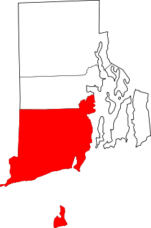 | |
| CDPs | ||
| Other villages | ||
| Islands |  | |
|---|---|---|
| Major rivers | ||
| Cities & towns | ||
| Bridges | ||
Providence (capital) | |
| Topics |
|
| Society |
|
| Regions | |
| Cities | |
| Towns |
|