Troy, New Hampshire
| Troy, New Hampshire | |
|---|---|
| Town | |
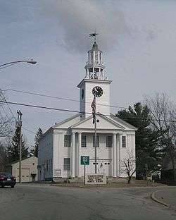 Town Hall | |
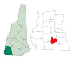 Location in Cheshire County, New Hampshire | |
| Coordinates: 42°49′30″N 72°11′01″W / 42.82500°N 72.18361°WCoordinates: 42°49′30″N 72°11′01″W / 42.82500°N 72.18361°W | |
| Country | United States |
| State | New Hampshire |
| County | Cheshire |
| Incorporated | 1815 |
| Villages |
Troy Bowkerville |
| Government | |
| • Board of Selectmen |
Dick Thackston, Chair Curtis Hopkins Barbara Guelcher |
| Area | |
| • Total | 17.6 sq mi (45.5 km2) |
| • Land | 17.4 sq mi (45.1 km2) |
| • Water | 0.2 sq mi (0.4 km2) 0.89% |
| Elevation | 1,010 ft (308 m) |
| Population (2010) | |
| • Total | 2,145 |
| • Density | 123/sq mi (47.5/km2) |
| Time zone | UTC-5 (Eastern) |
| • Summer (DST) | UTC-4 (Eastern) |
| ZIP code | 03465 |
| Area code(s) | 603 |
| FIPS code | 33-77380 |
| GNIS feature ID | 0873740 |
| Website |
www |
Troy is a town in Cheshire County, New Hampshire, United States. The population was 2,145 at the 2010 census.[1] It is situated at the base of Mount Monadnock.
The town center village, where 1,221 people resided at the 2010 census,[2] is defined as the Troy census-designated place (CDP), and is located along New Hampshire Route 12. It is listed on the National Register of Historic Places as Troy Village Historic District.
History

Settled in 1762, by 1815 the community had grown so much that it sought its own incorporation.[3] It was set off from Marlborough that year, and included parts of Fitzwilliam, Swanzey and Richmond. A prominent citizen and friend of Governor John Taylor Gilman, Captain Benjamin Mann of Mason, suggested the name Troy. His daughter, Betsy, was married to Samuel Wilson, famous as "Uncle Sam", and at that time a resident of Troy, New York. At least seven members of Wilson's family were living in the town at the time, thus securing the name. The town hall, built in 1813-1814 near the rail-fenced common, was originally the village meetinghouse.[4]
Troy Mills, which started making horse blankets in the mid-19th century, served as the backbone of the town's economy for nearly 100 years. In 1865, the company was sold by founder Thomas Goodall, who in 1867 would establish Goodall Mills in Sanford, Maine. Troy Mills declared bankruptcy in late 2001, and ceased operations in 2002. The giant mill complex on Monadnock Street now houses two smaller spin-offs of Troy Mills—Knowlton Nonwovens and Cosmopolitan Textiles. The Troy trademark is now used for felt made by a company in West Virginia. Wooden-ware, pottery and fine building stone were also once the products of Troy industries. As of 2008, Troy Mills was being renovated to become a retirement community.[5]
Geography
According to the United States Census Bureau, the town has a total area of 17.6 square miles (45.5 km2), of which 17.4 square miles (45.1 km2) is land and 0.2 square miles (0.4 km2) is water, comprising 0.89% of the town.[1] Troy is drained by the South Branch of the Ashuelot River.

The highest point in town is the south summit of Gap Mountain, at 1,900 feet (580 m) above sea level, near the eastern border. The summit of Mount Monadnock is 2 miles (3 km) northeast of the town in Jaffrey.
Troy is crossed by New Hampshire Route 12 and New Hampshire Route 124. NH 12 passes through the center of town and leads northwest 9 miles (14 km) to Keene and southeast 12 miles (19 km) to Winchendon, Massachusetts, while NH 124, crossing the northeast corner of the town, leads northwest 6 miles (10 km) to the center of Marlborough and east 6 miles (10 km) to the center of Jaffrey.
Demographics
| Historical population | |||
|---|---|---|---|
| Census | Pop. | %± | |
| 1820 | 676 | — | |
| 1830 | 676 | 0.0% | |
| 1840 | 683 | 1.0% | |
| 1850 | 759 | 11.1% | |
| 1860 | 761 | 0.3% | |
| 1870 | 767 | 0.8% | |
| 1880 | 796 | 3.8% | |
| 1890 | 999 | 25.5% | |
| 1900 | 1,527 | 52.9% | |
| 1910 | 1,331 | −12.8% | |
| 1920 | 1,444 | 8.5% | |
| 1930 | 1,267 | −12.3% | |
| 1940 | 1,321 | 4.3% | |
| 1950 | 1,360 | 3.0% | |
| 1960 | 1,445 | 6.3% | |
| 1970 | 1,713 | 18.5% | |
| 1980 | 2,131 | 24.4% | |
| 1990 | 2,097 | −1.6% | |
| 2000 | 1,962 | −6.4% | |
| 2010 | 2,145 | 9.3% | |
| Est. 2015 | 2,086 | [6] | −2.8% |
| U.S. Decennial Census[7] | |||
As of the census of 2010, there were 2,145 people, 867 households, and 568 families residing in the town. The population density was 123.1 people per square mile (47.5/km²). There were 932 housing units at an average density of 53.5 per square mile (20.7/km²). The racial makeup of the town was 97.0% White, 0.8% African American, 0.7% Native American, 0.9% Asian, 0.05% some other race, and 0.5% from two or more races. Hispanic or Latino of any race were 1.3% of the population.[8] As of the 2000 census, 18.7% were of American, 13.4% French, 11.8% English, 10.6% Irish, 8.4% French Canadian, 8.2% Finnish and 7.0% Italian ancestry.
At the 2010 census there were 867 households, out of which 31.5% had children under the age of 18 living with them, 49.3% were headed by married couples living together, 11.2% had a female householder with no husband present, and 34.5% were non-families. 26.2% of all households were made up of individuals, and 7.6% were someone living alone who was 65 years of age or older. The average household size was 2.47, and the average family size was 2.96.[8]
In the town, the population was spread out with 23.1% under the age of 18, 8.1% from 18 to 24, 28.5% from 25 to 44, 29.0% from 45 to 64, and 11.5% who were 65 years of age or older. The median age was 37.8 years. For every 100 females, there were 99.7 males. For every 100 females age 18 and over, there were 97.8 males.[8]
For the period 2010–14, the estimated median annual income for a household in the town was $55,043, and the median income for a family was $59,750. Male full-time workers had a median income of $45,800 versus $28,359 for females. The per capita income for the town was $29,045. About 4.9% of families and 8.5% of the population were below the poverty line, including 12.6% of those under age 18 and 17.3% of those age 65 or over.[9]
Education
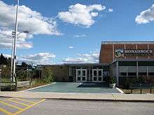
Residents of Troy attending public high school go to Troy Elementary school for kindergarten to 6th grade, and Monadnock Regional High School for 7th through 12th grades. Both schools are part of the Monadnock Regional School District (SAU93).[10] Troy is the second largest town in the Monadnock Regional School District, the largest being Swanzey. Other towns in the school district are Fitzwilliam, Gilsum, Richmond and Roxbury.
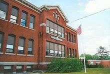
The elementary school is located in Troy, whereas the middle-high school is to the north in the town of Swanzey. Troy School has been educating the children of Troy since 1895 when it was built to house 225 children of all ages. Troy School presently accommodates approximately 135 students in grades K-6. The school day starts at 8:30 AM and ends at 3:10 PM. Students may enter the building at 8:15 AM to have breakfast and get ready for class.
The town of Troy also has two 2015 NH licensed child care facilities with a capacity for up to 75 children.
Notable people
- Ira Allen Eastman, member of the United States House of Representatives[11]
References
- 1 2 "Geographic Identifiers: 2010 Census Summary File 1 (G001): Troy town, Cheshire County, New Hampshire". American Factfinder. U.S. Census Bureau. Retrieved January 20, 2016.
- ↑ "Geographic Identifiers: 2010 Census Summary File 1 (G001): Troy CDP, New Hampshire". American Factfinder. U.S. Census Bureau. Retrieved January 20, 2016.
- ↑ "Troy, New Hampshire". City-Data.com. Retrieved December 5, 2013.
- ↑ Coolidge, Austin J.; John B. Mansfield (1859). A History and Description of New England. Boston, Massachusetts. p. 666.
- ↑ "The Residences at Troy Blanket Mills". Troy Mills Developers. Retrieved 2008-02-23.
- ↑ "Annual Estimates of the Resident Population for Incorporated Places: April 1, 2010 to July 1, 2015". Archived from the original on June 2, 2016. Retrieved July 2, 2016.
- ↑ "Census of Population and Housing". Census.gov. Retrieved June 4, 2016.
- 1 2 3 "Profile of General Population and Housing Characteristics: 2010 Census Summary File 1 (DP-1): Troy town, Cheshire County, New Hampshire". American Factfinder. U.S. Census Bureau. Retrieved January 20, 2016.
- ↑ "Selected Economic Characteristics: 2010-2014 American Community Survey 5-Year Estimates (DP03): Troy town, Cheshire County, New Hampshire". American Factfinder. U.S. Census Bureau. Retrieved January 20, 2016.
- ↑ "Monadnock Regional School District". Monadnock Regional School District. Retrieved December 5, 2013.
- ↑ "EASTMAN, Ira Allen, (1809 - 1881)". Biographical Directory of the United States Congress. Retrieved December 5, 2013.
External links
| Wikimedia Commons has media related to Troy, New Hampshire. |
- Town of Troy official website
- Troy Town News
- Gay-Kimball Library
- New Hampshire Economic and Labor Market Information Bureau Profile
Places adjacent to Troy, New Hampshire | |
|---|---|
Municipalities and communities of Cheshire County, New Hampshire, United States | ||
|---|---|---|
| City | 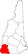 | |
| Towns | ||
| CDPs | ||
| Other villages | ||