Providence County, Rhode Island
| Providence County, Rhode Island | |
|---|---|
| Counties in Rhode Island | |
| County of Providence | |
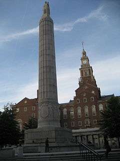 Providence County Courthouse | |
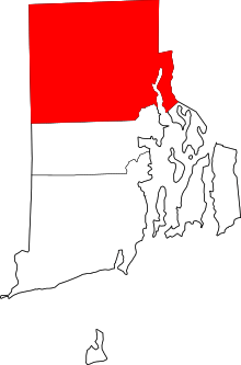 Location in the U.S. state of Rhode Island | |
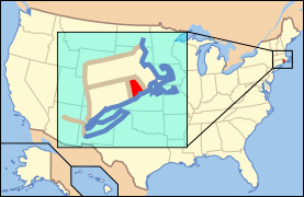 Rhode Island's location in the U.S. | |
| Founded | June 22, 1703 |
| Seat | Providence (1703-1842) |
| Largest city | Providence |
| Area | |
| • Total | 436 sq mi (1,129 km2) |
| • Land | 410 sq mi (1,062 km2) |
| • Water | 26 sq mi (67 km2), 6.0% |
| Population (est.) | |
| • (2016) | 633,473 |
| • Density | 1,545/sq mi (596.5/km2) |
| Congressional districts | 1st, 2nd |
| Time zone | Eastern: UTC−5/−4 |
Providence County is the most populous county in the U.S. state of Rhode Island. As of the 2010 census, the county's population was 626,667, or 59.5% of the state's population.[1] Providence County contains the city of Providence, the state capital of Rhode Island and the county's (and state's) most populous city, with an estimated 179,219 residents in 2016.[2] Providence County is included in the Providence-Warwick, RI-MA Metropolitan Statistical Area, which in turn constitutes a portion of the greater Boston-Worcester-Providence, MA-RI-NH-CT Combined Statistical Area. In 2010, the center of population of Rhode Island was located in Providence County, in the city of Cranston.[3]
History
Providence County was constituted on June 22, 1703, as the County of Providence Plantations. It consisted of five towns, namely Providence, Warwick, Westerly, Kingstown, and Greenwich and encompassed territory in present-day Kent and Washington counties. Washington County was split off as King's County in 1729, while Kent County was split off in 1750. The town of Cumberland was acquired from Massachusetts and added to Providence County in 1746-47, and the towns of East Providence and Pawtucket were made part of Providence County when the final border with Massachusetts was settled in 1862. County government in Rhode Island was abolished in 1842. Providence County, like other counties in Rhode Island, has no governmental functions (other than as court administrative and sheriff corrections boundaries which are part of state government).
Geography
According to the U.S. Census Bureau, the county has a total area of 436 square miles (1,130 km2), of which 410 square miles (1,100 km2) is land and 26 square miles (67 km2) (6.0%) is water.[4] It is the largest of Rhode Island's five counties by land area. The county is drained by the Blackstone River, which runs partly along the east border, the Woonasquatucket River in the central part of the county, joining with the smaller Moshassuck River in downtown Providence, and the Pawtuxet, which forms a portion of the southeastern boundary of the county.[5] The Pawtuxet is dammed in the western part of the county to form the Scituate Reservoir, which supplies drinking water for Providence and surrounding communities.
The highest natural point in the county and the state of Rhode Island is Jerimoth Hill at 812 feet (247 m). Sea level is the lowest point.
Adjacent counties
- Norfolk County, Massachusetts - northeast
- Bristol County, Massachusetts - east
- Bristol County - southeast
- Kent County - south
- Windham County, Connecticut - west
- Worcester County, Massachusetts - northwest
National protected area
Demographics
| Historical population | |||
|---|---|---|---|
| Census | Pop. | %± | |
| 1790 | 24,376 | — | |
| 1800 | 25,854 | 6.1% | |
| 1810 | 30,869 | 19.4% | |
| 1820 | 35,736 | 15.8% | |
| 1830 | 47,018 | 31.6% | |
| 1840 | 58,073 | 23.5% | |
| 1850 | 87,526 | 50.7% | |
| 1860 | 107,799 | 23.2% | |
| 1870 | 149,190 | 38.4% | |
| 1880 | 197,874 | 32.6% | |
| 1890 | 255,123 | 28.9% | |
| 1900 | 328,683 | 28.8% | |
| 1910 | 424,353 | 29.1% | |
| 1920 | 475,190 | 12.0% | |
| 1930 | 540,016 | 13.6% | |
| 1940 | 550,298 | 1.9% | |
| 1950 | 574,973 | 4.5% | |
| 1960 | 568,778 | −1.1% | |
| 1970 | 580,261 | 2.0% | |
| 1980 | 571,349 | −1.5% | |
| 1990 | 596,270 | 4.4% | |
| 2000 | 621,602 | 4.2% | |
| 2010 | 626,667 | 0.8% | |
| Est. 2017 | 637,537 | [6] | 1.7% |
| U.S. Decennial Census[7] 1790-1960[8] 1900-1990[9] 1990-2000[10] 2010-2015[1] | |||
2000 census
As of the census[11] of 2000, there were 621,602 people, 239,936 households, and 152,839 families residing in the county. The population density was 1,504 people per square mile (581/km²). There were 253,214 housing units at an average density of 613 per square mile (237/km²). The racial makeup of the county was 78.38% White, 6.55% Black or African American, 0.51% Native American, 2.90% Asian, 0.07% Pacific Islander, 8.02% from other races, and 3.58% from two or more races. 13.39% of the population were Hispanic or Latino of any race. 19.0% were of Italian, 10.9% Irish, 8.1% French, 7.7% Portuguese, 7.2% French Canadian and 5.8% English ancestry according to Census 2000. 72.7% spoke English, 13.4% Spanish, 4.9% Portuguese, 2.5% French and 1.6% Italian as their first language.
There were 239,936 households out of which 30.70% had children under the age of 18 living with them, 44.50% were married couples living together, 14.90% had a female householder with no husband present, and 36.30% were non-families. 29.80% of all households were made up of individuals and 11.90% had someone living alone who was 65 years of age or older. The average household size was 2.48 and the average family size was 3.11.
In the county, the population was spread out with 24.00% under the age of 18, 11.10% from 18 to 24, 29.80% from 25 to 44, 20.50% from 45 to 64, and 14.60% who were 65 years of age or older. The median age was 35 years. For every 100 females, there were 91.80 males. For every 100 females age 18 and over, there were 87.90 males.
The median income for a household in the county was $36,950, and the median income for a family was $46,694. Males had a median income of $35,336 versus $26,322 for females. The per capita income for the county was $19,255. About 11.90% of families and 15.50% of the population were below the poverty line, including 22.30% of those under age 18 and 12.70% of those age 65 or over.
Providence County is 71% Catholic, making it among the most Catholic counties in the country.[12]
2010 census
As of the 2010 United States Census, there were 626,667 people, 241,717 households, and 149,691 families residing in the county.[13] The population density was 1,530.3 inhabitants per square mile (590.9/km2). There were 264,835 housing units at an average density of 646.7 per square mile (249.7/km2).[14] The racial makeup of the county was 73.4% white, 8.5% black or African American, 3.7% Asian, 0.7% American Indian, 0.1% Pacific islander, 9.6% from other races, and 4.2% from two or more races. Those of Hispanic or Latino origin made up 18.8% of the population.[13] The largest ancestry groups were:


.svg.png)


Of the 241,717 households, 31.4% had children under the age of 18 living with them, 40.8% were married couples living together, 15.8% had a female householder with no husband present, 38.1% were non-families, and 30.2% of all households were made up of individuals. The average household size was 2.48 and the average family size was 3.11. The median age was 37.0 years.[13]
The median income for a household in the county was $48,500 and the median income for a family was $61,265. Males had a median income of $44,964 versus $36,447 for females. The per capita income for the county was $25,169. About 11.6% of families and 15.4% of the population were below the poverty line, including 22.1% of those under age 18 and 11.5% of those age 65 or over.[16]
Communities
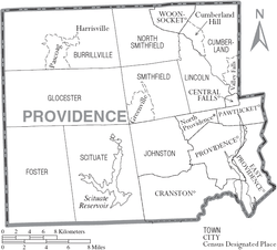
Cities
- Central Falls
- Cranston
- East Providence
- Pawtucket
- Providence (traditional county seat)
- Woonsocket
Towns
Census-designated places
Other villages
Politics
| Year | Republican | Democratic | Third parties |
|---|---|---|---|
| 2016 | 36.6% 90,882 | 57.5% 142,899 | 5.9% 14,693 |
| 2012 | 31.6% 75,785 | 66.5% 159,520 | 1.9% 4,481 |
| 2008 | 31.9% 81,010 | 66.0% 167,442 | 2.0% 5,178 |
| 2004 | 35.6% 82,337 | 62.6% 144,811 | 1.8% 4,176 |
| 2000 | 28.1% 61,378 | 65.3% 142,469 | 6.6% 14,461 |
| 1996 | 23.5% 49,901 | 63.6% 134,866 | 12.9% 27,355 |
| 1992 | 27.5% 69,579 | 49.5% 125,358 | 23.1% 58,504 |
| 1988 | 40.8% 94,248 | 58.8% 135,927 | 0.4% 984 |
| 1984 | 48.2% 116,024 | 51.5% 124,109 | 0.3% 765 |
| 1980 | 34.9% 86,467 | 51.2% 126,808 | 14.0% 34,652 |
| 1976 | 41.6% 103,976 | 58.0% 144,805 | 0.4% 1,036 |
| 1972 | 49.9% 129,418 | 49.9% 129,232 | 0.2% 506 |
| 1968 | 28.1% 70,320 | 67.6% 169,246 | 4.3% 10,633 |
| 1964 | 16.5% 43,432 | 83.5% 219,465 | |
| 1960 | 32.5% 91,028 | 67.5% 189,014 | 0.0% 1 |
| 1956 | 55.8% 153,860 | 44.2% 121,861 | |
| 1952 | 48.1% 146,197 | 51.8% 157,592 | 0.1% 219 |
| 1948 | 38.2% 93,867 | 60.7% 149,254 | 1.1% 2,627 |
| 1944 | 38.8% 87,190 | 61.1% 137,216 | 0.1% 321 |
| 1940 | 40.6% 99,434 | 59.3% 145,236 | 0.1% 251 |
| 1936 | 37.2% 88,492 | 55.1% 131,218 | 7.7% 18,370 |
| 1932 | 40.9% 84,397 | 57.4% 118,546 | 1.7% 3,601 |
| 1928 | 46.8% 85,884 | 52.9% 97,185 | 0.3% 568 |
| 1924 | 57.2% 92,464 | 38.6% 62,336 | 4.2% 6,750 |
| 1920 | 61.3% 79,558 | 35.3% 45,859 | 3.4% 4,374 |
| 1916 | 49.2% 32,406 | 47.5% 31,314 | 3.3% 2,172 |
| 1912 | 33.7% 19,695 | 39.6% 23,127 | 26.7% 15,587 |
| 1908 | 59.6% 32,037 | 35.1% 18,880 | 5.3% 2,854 |
| 1904 | 59.8% 30,295 | 36.6% 18,557 | 3.6% 1,846 |
| 1900 | 58.0% 24,194 | 36.5% 15,223 | 5.5% 2,274 |
| 1896 | 66.6% 26,844 | 28.9% 11,644 | 4.5% 1,832 |
| 1892 | 49.2% 18,695 | 47.9% 18,203 | 3.0% 1,134 |
| 1888 | 51.7% 14,207 | 45.3% 12,440 | 3.0% 812 |
| 1884 | 57.1% 12,387 | 39.1% 8,491 | 3.8% 824 |
| 1880 | 61.1% 11,316 | 37.7% 6,975 | 1.2% 217 |
See also
References
- 1 2 "State & County QuickFacts". United States Census Bureau. Retrieved November 22, 2013.
- ↑ "Population and Housing Unit Estimates". U.S. Census Bureau. Retrieved December 22, 2017.
- ↑ "Centers of Population by State: 2010". United States Census Bureau. Retrieved March 14, 2015.
- ↑ "2010 Census Gazetteer Files". United States Census Bureau. August 22, 2012. Retrieved March 14, 2015.
- ↑

- ↑ "Population and Housing Unit Estimates". Retrieved June 9, 2017.
- ↑ "U.S. Decennial Census". United States Census Bureau. Retrieved March 14, 2015.
- ↑ "Historical Census Browser". University of Virginia Library. Retrieved March 14, 2015.
- ↑ Forstall, Richard L., ed. (March 27, 1995). "Population of Counties by Decennial Census: 1900 to 1990". United States Census Bureau. Retrieved March 14, 2015.
- ↑ "Census 2000 PHC-T-4. Ranking Tables for Counties: 1990 and 2000" (PDF). United States Census Bureau. April 2, 2001. Retrieved March 14, 2015.
- ↑ "American FactFinder". United States Census Bureau. Retrieved 2011-05-14.
- ↑ "Adherents.com: Catholics". www.adherents.com. Retrieved 18 March 2018.
- 1 2 3 "DP-1 Profile of General Population and Housing Characteristics: 2010 Demographic Profile Data". United States Census Bureau. Retrieved 2016-01-12.
- ↑ "Population, Housing Units, Area, and Density: 2010 - County". United States Census Bureau. Retrieved 2016-01-12.
- ↑ "DP02 SELECTED SOCIAL CHARACTERISTICS IN THE UNITED STATES – 2006-2010 American Community Survey 5-Year Estimates". United States Census Bureau. Retrieved 2016-01-12.
- ↑ "DP03 SELECTED ECONOMIC CHARACTERISTICS – 2006-2010 American Community Survey 5-Year Estimates". United States Census Bureau. Retrieved 2016-01-12.
- ↑ Leip, David. "Dave Leip's Atlas of U.S. Presidential Elections". uselectionatlas.org. Retrieved 18 March 2018.
Places adjacent to Providence County, Rhode Island | ||||||||||
|---|---|---|---|---|---|---|---|---|---|---|
| ||||||||||
Municipalities and communities of Providence County, Rhode Island, United States | ||
|---|---|---|
| Cities | | |
| Towns | ||
| CDPs | ||
| Other villages | ||
Providence (capital) | |
| Topics |
|
| Society |
|
| Regions | |
| Cities | |
| Towns |
|