Newfields, New Hampshire
| Newfields, New Hampshire | |
|---|---|
 Swamscott Street | |
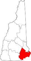
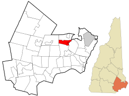 Location in Rockingham County and the state of New Hampshire. | |
| Coordinates: 43°02′13″N 70°56′18″W / 43.03694°N 70.93833°WCoordinates: 43°02′13″N 70°56′18″W / 43.03694°N 70.93833°W | |
| Country | United States |
| State | New Hampshire |
| County | Rockingham |
| Incorporated | 1849 |
| Villages |
Newfields Littlefield |
| Government | |
| • Board of Selectmen |
Christopher Hutchins, Chair James Thompson Michael Sununu |
| Area | |
| • Total | 7.2 sq mi (18.6 km2) |
| • Land | 7.0 sq mi (18.2 km2) |
| • Water | 0.2 sq mi (0.4 km2) 2.23% |
| Elevation | 75 ft (23 m) |
| Population (2010) | |
| • Total | 1,680 |
| • Density | 230/sq mi (90/km2) |
| Time zone | UTC-5 (Eastern) |
| • Summer (DST) | UTC-4 (Eastern) |
| ZIP code | 03856 |
| Area code(s) | 603 |
| FIPS code | 33-51380 |
| GNIS feature ID | 0873678 |
| Website |
www |
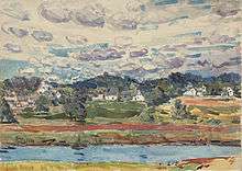
Newfields is a town in Rockingham County, New Hampshire, United States. The population was 1,680 at the 2010 census.[1] The primary village in town, where 301 people resided at the 2010 census,[1] is defined as the Newfields census-designated place (CDP), and is located along New Hampshire Route 85 and the Squamscott River. It is a quaint village of handsome old houses.
History
Incorporated in 1849, Newfields was part of Exeter until 1727, when it became part of Newmarket. Settled in 1638, it was called "Newfield Village" as early as 1681, and later "South Newmarket", a parish of that town.
The name "Newfields" was not used by census takers until 1900. Previously, it was listed as "South New Market" (1850), "South Newmarket" (1860 and 1880), or simply as "Newmarket" (1870).[2]
Garrison houses, built as protection against Indian attack, were not uncommon. Among the earliest tithingmen in the village were Jonathan Robinson (1678), Abraham and Jeremiah Folsom (1720), Andrew Glidden (1721), Trueworthy Leavitt (1725), Samuel Edgerly (1728), Nathaniel Gilman (1729) and Nathaniel Webster (1729).[3]
In 1775, a bridge was built across the Squamscott River connecting the community with Stratham. This shortened the journey to Exeter, established that year as the Revolutionary capital. But the new route bypassed the center of town, built on either side of an ancient Squamscot Indian trail. This preserved old Newfields.
Wesleyan Academy was established here in 1817, a Methodist school of five boys and five girls under the tutelage of Reverend John Brodhead and others. Coeducation was then rather advanced. Unfortunately, the academy struggled financially from the start because of, as administrators would conclude, "...its location in a setting of relatively few Methodists, of limited means..." And so, in 1825, it removed to Wilbraham, Massachusetts. The academy's site is now occupied by the Newfields Elementary School, with about 170 children as of 2011, from grades K-5.
In 1841, the Boston and Maine Railroad extended service to the community. In 1880, Dr. John M. Brodhead presented his own library and $10,000 to the town on condition that it be renamed Newfields. The town was so incorporated in 1895.
Gallery
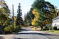 Main Street
 Newfields Country Store
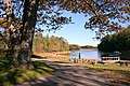 Town landing
Geography
According to the United States Census Bureau, the town has a total area of 7.2 square miles (18.6 km2), of which 7.0 sq mi (18.1 km2) is land and 0.2 sq mi (0.5 km2) is water, comprising 2.23% of the town. It is drained by the Piscassic River, a tributary of the Lamprey River, and bounded to the east by the Squamscott River. The highest point in Newfields is the summit of Oakland Hill at 240 feet (73 m) above sea level, on the town's southern border.
The town is crossed by New Hampshire Route 85, New Hampshire Route 87 and New Hampshire Route 108.
Demographics
| Historical population | |||
|---|---|---|---|
| Census | Pop. | %± | |
| 1850 | 516 | — | |
| 1860 | 786 | 52.3% | |
| 1870 | 808 | 2.8% | |
| 1880 | 829 | 2.6% | |
| 1890 | 855 | 3.1% | |
| 1900 | 647 | −24.3% | |
| 1910 | 503 | −22.3% | |
| 1920 | 470 | −6.6% | |
| 1930 | 376 | −20.0% | |
| 1940 | 417 | 10.9% | |
| 1950 | 469 | 12.5% | |
| 1960 | 737 | 57.1% | |
| 1970 | 843 | 14.4% | |
| 1980 | 817 | −3.1% | |
| 1990 | 888 | 8.7% | |
| 2000 | 1,551 | 74.7% | |
| 2010 | 1,680 | 8.3% | |
| Est. 2015 | 1,695 | [4] | 0.9% |
| U.S. Decennial Census[5] | |||
As of the census of 2010, there were 1,680 people, 575 households, and 487 families residing in the town. There were 591 housing units, of which 16, or 2.7%, were vacant. The racial makeup of the town was 97.5% white, 0.4% African American, 0.1% Native American, 1.0% Asian, 0.0% Native Hawaiian or Pacific Islander, 0.4% some other race, and 0.6% from two or more races. 1.3% of the population were Hispanic or Latino of any race.[6]
Of the 575 households, 44.5% had children under the age of 18 living with them, 76.3% were headed by married couples living together, 5.7% had a female householder with no husband present, and 15.3% were non-families. 10.6% of all households were made up of individuals, and 4.2% were someone living alone who was 65 years of age or older. The average household size was 2.92, and the average family size was 3.19.[6]
In the town, 28.6% of the population were under the age of 18, 5.4% were from 18 to 24, 20.5% from 25 to 44, 36.6% from 45 to 64, and 9.1% were 65 years of age or older. The median age was 43.1 years. For every 100 females, there were 103.4 males. For every 100 females age 18 and over, there were 99.5 males.[6]
For the period 2011-2015, the estimated median annual income for a household was $118,333, and the median income for a family was $129,766. The per capita income for the town was $52,945. 1.7% of the population and 1.1% of families were below the poverty line. 1.1% of the population under the age of 18 and 8.0% of those 65 or older were living in poverty.[7]
Notable people
- William Badger (1752–1830), master shipbuilder
- John Brodhead (1770–1838), US congressman
- Winthrop Hilton (1671–1710), colonial military officer
- James Pike (1818–1895), US congressman
- Anita Shreve (1946-2018), novelist perhaps best known for The Weight of Water
- Chris Sununu (b. 1974), New Hampshire governor
References
- 1 2 United States Census Bureau, American FactFinder, 2010 Census figures. Retrieved March 23, 2011.
- ↑ U.S. Federal Census Collection: http://search.ancestry.com/search/group/usfedcen
- ↑ History of Newfields, New Hampshire, 1638–1911, James Hill Fitts, Printed by J. Lane Fitts, Concord, New Hampshire, 1912
- ↑ "Annual Estimates of the Resident Population for Incorporated Places: April 1, 2010 to July 1, 2015". Archived from the original on June 2, 2016. Retrieved July 2, 2016.
- ↑ "Census of Population and Housing". Census.gov. Retrieved June 4, 2016.
- 1 2 3 "Profile of General Population and Housing Characteristics: 2010 Census Summary File 1 (DP-1): Newfields town, Rockingham County, New Hampshire". American Factfinder. U.S. Census Bureau. Retrieved November 9, 2017.
- ↑ "Selected Economic Characteristics: 2011-2015 American Community Survey 5-Year Estimates (DP03): Newfields town, Rockingham County, New Hampshire". American Factfinder. U.S. Census Bureau. Retrieved November 9, 2017.
External links
- Town of Newfields official website
- Newfields Public Library
- New Hampshire Economic and Labor Market Information Bureau Profile
- History of Newfields, New Hampshire, 1638-1911, James Hill Fitts, 1912
Places adjacent to Newfields, New Hampshire | |
|---|---|