Weston, Massachusetts
| Weston, Massachusetts | ||
|---|---|---|
| Town | ||
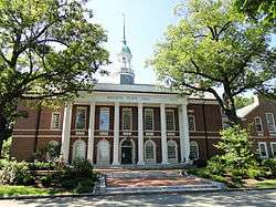 Town Hall | ||
| ||
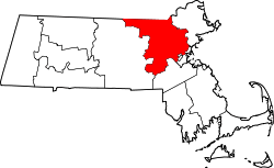
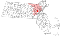 Location in Middlesex County in Massachusetts | ||
| Coordinates: 42°22′00″N 71°18′11″W / 42.36667°N 71.30306°WCoordinates: 42°22′00″N 71°18′11″W / 42.36667°N 71.30306°W | ||
| Country | United States | |
| State | Massachusetts | |
| County | Middlesex | |
| Settled | 1642 | |
| Incorporated | 1713 | |
| Area | ||
| • Total | 17.3 sq mi (44.9 km2) | |
| • Land | 17.0 sq mi (44.1 km2) | |
| • Water | 0.3 sq mi (0.8 km2) | |
| Elevation | 180 ft (55 m) | |
| Population (2010) | ||
| • Total | 11,261 | |
| • Density | 650/sq mi (250/km2) | |
| Time zone | UTC-5 (Eastern) | |
| • Summer (DST) | UTC-4 (Eastern) | |
| ZIP code | 02493 | |
| Area code(s) | 781 / 339 | |
| FIPS code | 25-77255 | |
| GNIS feature ID | 0618245 | |
| Website |
www | |
Weston is a town in Middlesex County, Massachusetts, about 15 miles west of downtown Boston. The population of Weston, as of June 2017, was 11,389.[1]
Weston was incorporated in 1713, and protection of the town's historic resources is driven by the Weston Historical Commission and Weston Historical Society. The town has one Local Historic District, 10 National Register Districts, 26 Historic Areas, and seven houses individually listed on the National Register of Historic Places.[2]
In the town’s 2014 Community Livability Survey, 97 percent of respondents rated Weston an excellent or good place to live. Among the survey's eight "facets of community livability," four of them—education, natural environment, safety, and community engagement—were rated higher than national benchmarks.
Weston's predominance as a residential community is reflected in its population density, which is among the lowest of Boston's suburbs near or within Route 128.[3] More than 2,000 acres, or 18 percent of the town's total acreage, have been preserved as parks, fields, wetlands, and forests, with 90 miles of trails for hiking, horseback riding, and cross-country skiing.[4][5] Thirty-seven scenic roads, as defined by Massachusetts law,[6] maintain the town's aesthetic value and historical significance, affording Weston a semi-rural ambiance.[7]
In 2017, Boston magazine ranked Weston Public Schools as the third best public school district in greater Boston,[8] and in 2018, Weston High School was ranked as the fourth best public high school.[9]
In 2018 Bloomberg ranked Weston, with an average adjusted gross income of $860,400, as the 9th richest zip code in the United States and the 3rd richest in the Northeast.[10]
History
The description of Weston's history here is pulled directly from the 2017 Weston Open Space and Recreation Plan.
Early years
Weston was originally part of the Watertown settlement of 1630, but until the end of the century, the land was used mainly for grazing cattle. In 1698, “The Farms” was set off as a separate precinct with its own meetinghouse; and in 1712-13, the “Farmers’ Precinct” was incorporated as a separate town, Weston.
Early settlers discovered that the amount of useful agricultural land was limited, as was the potential for water-powered industries. Weston did have one advantage: it was situated along the main route west from Boston. By the 18th century, residents were providing services to travelers on the Boston Post Road. Two taverns of great historical and architectural importance remain today: the Josiah Smith Tavern and the Golden Ball Tavern, which is now a museum. North Avenue was an important route to the northwest and, like the Post Road, hosted shops, blacksmiths, and taverns serving travelers.
Grist and sawmills were established beginning in the 17th century on Stony Brook and in the Crescent Street area. Two important manufacturing enterprises were begun during the Colonial period: the Hews redware pottery on Boston Post Road and Hobbs Tannery on North Avenue. By 1776, Weston’s population of 1,027 was spread throughout the town on scattered farms along major roads, with some consolidation within the village center around the meetinghouse, along the length of the Post Road, and on North Avenue.
The opening of the Worcester Turnpike in 1810 (now Route 9) drew some commercial traffic from the Boston Post Road, but dry goods merchants continued to supply neighboring towns until about 1830-40. The Boston and Worcester Railroad was built through the southeast corner of town in 1834, and the Fitchburg Railroad (later the Boston and Maine) was built along Stony Brook on the north side of town around 1844. Population continued to grow, supported in part by small industries such as the pottery, tannery and related boot and shoe making, school desk and chair factory, tool factories, and shops making machinery for cotton and woolen mills. The Hook & Hastings Company organ factory, Weston’s largest industry, moved to the North Avenue area in 1888 and was a major town employer until it closed during the Great Depression. The Mass Central Railroad, the third to serve Weston, commenced service in 1881. Its tracks ran east-west through the center of town.
The rural landscape of Weston and convenience to rail transportation also made it attractive as a summer resort area. The shingle-style Drabbington Lodge, once a popular summer resort, remains on North Avenue and is now a senior living community.
The estate era
Development of country estates in Weston began on a small scale in the 1860s and was widespread by 1900. Wealthy businessmen were attracted to Weston by its convenience to Boston, quiet country atmosphere, and low taxes, as well as the beauty of the area and that same rocky topography that in earlier years had proved unsuitable for farming. By the turn of the century, Weston was described as a “country town of residences of the first class.”
Population growth and the influence of large estate owners led to the construction of new institutional buildings, such as the fieldstone First Parish Church (1888), designed by the nationally known Boston firm of Peabody and Stearns and located on the site of earlier church meetinghouses. The first library (1899), central fire station (1914), and present town hall (1917) were also built during the estate era. Coinciding with the town’s Bicentennial in 1913, an ambitious Town Improvement Plan began the process of creating the Town Green by draining and landscaping an existing wetland.
Suburban development began in the early 20th century and increased with the advent of the auto mobile. Two prominent estates, the Winsor estate on Meadowbrook Road and Hubbard estate on the south side, were subdivided after World War I. In the 1910s and 1920s, estates were purchased for educational use (Regis College and Weston College/Campion Center) and as golf courses (Weston Golf Club and Pine Brook Country Club). Many other large properties remained as open farm fields or woodlands through the Great Depression and World War II.
The Weston Aqueduct and Reservoir (1901–03) and Hultman Aqueduct and Norumbega Reservoir (1938–40) were major public works projects constructed as part of the water supply system of greater Boston.
Postwar growth
After World War II, construction of Routes 128 and the Massachusetts Turnpike, along with pent up demand for housing, led to subdivision of former estate properties and farms throughout the town. The postwar period was characterized by exponential growth and proactive efforts to control and guide this growth in order to preserve the rural character of the town. In the early 1950s, Weston's selectmen initiated two important growth-control measures: a zoning bylaw increasing the amount of land needed to build and a land-acquisition policy reducing the amount of developable land by purchasing it for the town. More than half of the town’s housing stock was built in the thirty years between 1950 and 1979 and consisted largely of single family houses on increasingly expensive land. Population growth brought increased demand for town services including schools, and five new schools were constructed between 1950 and 1969. In recent years, the major trend is for many of these postwar houses to be replaced by much larger houses.
Geography
According to the United States Census Bureau, the town has a total area of 17.3 square miles (45 km2), of which 17.0 square miles (44 km2) is land and 0.3 square miles (0.78 km2), or 1.85%, is water.
The town is bordered by Newton and Waltham on the east; Wellesley to the south; Natick and Wayland to the west; and Lincoln to the north.
Demographics
| Historical population | ||
|---|---|---|
| Year | Pop. | ±% |
| 1850 | 1,205 | — |
| 1860 | 1,243 | +3.2% |
| 1870 | 1,261 | +1.4% |
| 1880 | 1,448 | +14.8% |
| 1890 | 1,664 | +14.9% |
| 1900 | 1,834 | +10.2% |
| 1910 | 2,106 | +14.8% |
| 1920 | 2,282 | +8.4% |
| 1930 | 3,332 | +46.0% |
| 1940 | 3,590 | +7.7% |
| 1950 | 5,026 | +40.0% |
| 1960 | 8,261 | +64.4% |
| 1970 | 10,870 | +31.6% |
| 1980 | 11,169 | +2.8% |
| 1990 | 10,200 | −8.7% |
| 2000 | 11,469 | +12.4% |
| 2010 | 11,261 | −1.8% |
| * = population estimate. Source: United States Census records and Population Estimates Program data.[11][12][13][14][15][16][17][18][19][20] | ||
As of the census[21] of 2000, there were 11,469 people, 3,718 households, and 2,992 families residing in the town. The population density was 674.0 people per square mile (260.2/km²). There were 3,825 housing units at an average density of 224.8 per square mile (86.8/km²). The racial makeup of the town was 90.26% White, 1.18% African American, 0.05% Native American, 6.82% Asian, 0.05% Pacific Islander, 0.43% from other races, and 1.21% from two or more races. Hispanic or Latino of any race were 1.90% of the population.
There were 3,718 households out of which 42.3% had children under the age of 18 living with them, 73.1% were married couples living together, 5.6% had a female householder with no husband present, and 19.5% were non-families. 17.2% of all households were made up of individuals and 10.5% had someone living alone who was 65 years of age or older. The average household size was 2.85 and the average family size was 3.21.
In the town, the population was spread out with 28.0% under the age of 18, 7.3% from 18 to 24, 20.4% from 25 to 44, 27.8% from 45 to 64, and 16.5% who were 65 years of age or older. The median age was 42 years. For every 100 females, there were 86.6 males. For every 100 females age 18 and over, there were 79.6 males.
The median income for a household in the town was $153,918 and the median income for a family was $200,000+, figures that had risen to $189,041 and over $230,000 by 2007. Males had a median income of $100,000 versus $58,534 for females. The per capita income for the town was $105,640. About 2.1% of families and 2.9% of the population were below the poverty line, including 1.8% of those under age 18 and 3.9% of those age 65 or over.
In 2017 Forbes ranked Weston, with an average home median price of $2,410,897, as the 117th most expensive zip code in the United States.[22] In 2016 Weston had the highest proportion of million-dollar earners among Massachusetts towns, about 47 per 1,000 residents.[23]
Politics
As of December 2017, there were 7,632 active registered voters in Weston, with 501 voters listed as inactive. Among party enrollees, 1,869 were Democrats, and 1,211 Republicans, with the balance unenrolled.[24]
Like much of New England, Weston has trended strongly Democratic on the federal level in recent years. Weston supported Ronald Reagan in 1980 and 1984, as well as George H.W. Bush in 1988, against homestate Governor Mike Dukakis for president of the United States. However, it supported Bill Clinton in 1992, and has supported the Democratic candidate in every election since then, including Barack Obama over Mitt Romney, and Hillary Clinton over Donald Trump.
Weston is located entirely within Massachusetts's 5th congressional district.
Weston is represented in the Massachusetts Senate by Michael J. Barrett (D).
Massachusetts is represented in the United States Senate by senior Senator Elizabeth Warren and junior Senator Ed Markey.
Education
Public elementary and secondary schools
Weston Public Schools (WPS) operates five schools:
- Country School and Woodland School (both preK-grade 3, with students assigned randomly)
- Field School (grades 4-5), whose building was named by the Boston Society of Architects as a finalist for the 2015 Harleston Parker Medal
- Weston Middle School (grades 6-8)
- Weston High School (grade 9-12)
Districtwide enrollment in October 2017 was 2,104 students.[25] Among all Weston residents eligible to pursue elementary and secondary education in 2017, 76 percent were WPS students, 22 percent were students at private schools, and 2 percent were home schooled or attended other institutions.[26] WPS has participated in the METCO program since 1967.[27]
In 2018, Boston magazine ranked Weston High School the fourth best public high school in greater Boston.[28]
Private elementary and secondary schools
Undergraduate and graduate institutions
According to the 2010 U.S. Census, 79 percent of Weston's population over 25 years possesses a bachelor's degree, the third highest percentage among Massachusetts towns, following Carlisle and Sherborn.[29]
Transportation
The Massachusetts Turnpike traverses Weston in an east-west direction in the southern portion of town. Route 128 passes north-south on the town's eastern edge. The intersection of the Massachusetts Turnpike and Route 128 is located in southeastern Weston.
Several state highways—Route 20, Route 30, and Route 117—travel east-west through town.
Weston is served by three MBTA commuter rail stations--Silver Hill, Kendall Green, and Hastings—all on the Fitchburg Line, with terminus at Boston's North Station.
Culture
Weston Public Library
The Weston Public Library (WPL), with holdings of 209,000,[30] offers services and programs for adults and youth. With an annual circulation of 347,635 materials, which translates into 6,685 items checked out per week,[31] WPL has one of the highest per-capita circulation rates of all libraries in Massachusetts.[32] The Friends of the Weston Public Library provide financial support for the library's Local History Room, curate an ongoing rotation of art created by local artists, organize a series of musical concerts in the library's community room, and fund passes to Boston-area museums.
Weston Art and Innovation Center
The Weston Art and Innovation Center, scheduled to open in Weston's Old Library in 2019, will offer hands-on learning opportunities related to art and technology. The Weston Media Center will also relocate to the WAIC.
Weston Friendly Society
The Weston Friendly Society, founded in 1885, is the second oldest community theatre in the United States.[33] WFS performs musicals in the auditorium of Weston Town Hall several times a year. WFS donates money from its productions to local charitable causes.
Weston Drama Workshop
Weston Drama Workshop, founded in 1962, is a summer youth theatre program. Performers and support staff consist of students from fifth grade to the age of 23 years. Productions were originally held at Country School and Weston High School, but since 1994, WDW has held its performances at Regis College.
Periodicals
News and features of interest to Weston residents are published in two periodicals: The Weston Town Crier, a weekly newspaper, and WellesleyWeston, a quarterly magazine launched in 2005. Both are available in the Weston Public Library and have an online presence.
Religious institutions
- Campion Center
- Congregational Church of Weston, United Church of Christ
- Church of Jesus Christ of Latter-day Saints, Weston First Ward
- First Parish Church, Unitarian Universalist
- St. Demetrios Greek Orthodox Church
- St. Julia's Catholic Church
- St. Peter's Episcopal Church
- Westgate Church
- Weston United Methodist Church
Points of interest
- Abel Allen House
- Boston Post Road Historic District
- Case Estates
- Case's Corner Historic District
- Charles River Reservation Parkways
- Edward Peirce House, Henderson House of Northeastern University
- Glen Road Historic District
- Golden Ball Tavern
- Harrington House
- Isaac Hobbs House
- Josiah Smith Tavern
- Kendall Green Historic District
- Land's Sake Farm
- Leo J. Martin Golf Course, one of two golf courses operated by the State of Massachusetts
- Memorial Pool
- National Registry of Historic Places in Weston
- Norumbega Tower
- Rev. Samuel Woodward House
- Samuel Train House
- Silver Hill Historic District
- Spellman Museum of Stamps & Postal History
- Wellington Farm Historic District
- Weston Aqueduct
- Weston Aqueduct Linear District
- Weston Observatory (Boston College), a geophysical research and science education center of the Department of Earth and Environmental Sciences at Boston College.
- Weston Reservoir
- Weston Ski Track, open from December to March at Leo J. Martin Golf Course for cross-country skiing and snow shoeing.
- Weston Station (MBTA)
- Weston Town Green, site of the Weston High School graduation ceremony, spring and fall festivals, Easter egg hunt, and summer outdoor concert series.
- Weston Trail Maps
Notable people
- Anant Agarwal, professor of computer engineering at MIT and CEO of edX
- Frederic C. Dumaine, Jr., American business executive and Chairman of the Massachusetts Republican Party from 1963-1965
- David Frank, producer, composer, classically trained pianist, and founding member of the 1980s R&B group The System
- Sarah Fuller, author and educator who taught Helen Keller
- Jeremy Jacobs, owner of the Boston Bruins
- Stephen D. Lebovitz, CEO of CBL & Associates Properties[34]
- Grover Norquist, founder and president of Americans for Tax Reform
- Stephen Pagliuca, managing director of Bain Capital, co-owner of the Boston Celtics
- Anne Sexton, Pulitzer Prize-winning poet
- Amelia Vega, Winner of the Miss Universe beauty pageant in 2003
- Robert Winsor, prominent American banker and financier of the early 20th century
Sports figures
- Steve Belkin, owner of the Atlanta Hawks and formerly the Thrashers
- M. L. Carr, former Boston Celtics player and head coach
- Adrian Gonzalez former Boston Red Sox player
- John Harland, golf
- Matt Hasselbeck, former NFL quarterback
- John Havlicek, former Boston Celtics player
- Al Horford, current Boston Celtics player
- Kyrie Irving, current Boston Celtics player
- Cedric Maxwell, former Boston Celtics player and current radio announcer
- Bobby Orr, player for Boston Bruins
- David Ortiz, Boston Red Sox DH/1B
- James Pallotta, owner of the Boston Celtics and AS Roma; Founder of Raptor Capital Management
- Robert Parrish, former Boston Celtics player
- Jerry Remy, former Boston Red Sox player and current TV announcer
- Willard Rice, 1924 Olympic hockey player
- Jeff Vinik, owner of the Tampa Bay Lightning and minority owner of the Boston Red Sox
- Field Yates, analyst on NFL Insiders
- Kevin Youkilis, former Boston Red Sox player
References
- ↑ "Town of Weston, 2017 Annual Town Report, Statistics, p. 4".
- ↑ "Town of Weston, National Register Districts".
- ↑ "Boston.com, Snapshot: Population Density, 2011".
- ↑ "Weston Forest and Trail Association, Weston Trail Map".
- ↑ "2017 Weston Open Space and Recreation Plan".
- ↑ "General Laws of the Commonwealth of Massachusetts, Part I, Title VII, Chapter 40, Section 15C".
- ↑ "Town of Weston, Scenic Roads".
- ↑ "The Best School Districts in Greater Boston". Boston Magazine. Retrieved 2018-08-31.
- ↑ "The Best Public High Schools in Greater Boston". Boston Magazine. Retrieved 2018-08-31.
- ↑ "Bloomberg, America's Richest Zip Codes, April 2018".
- ↑ "Total Population (P1), 2010 Census Summary File 1". American FactFinder, All County Subdivisions within Massachusetts. United States Census Bureau. 2010.
- ↑ "Massachusetts by Place and County Subdivision - GCT-T1. Population Estimates". United States Census Bureau. Retrieved July 12, 2011.
- ↑ "1990 Census of Population, General Population Characteristics: Massachusetts" (PDF). US Census Bureau. December 1990. Table 76: General Characteristics of Persons, Households, and Families: 1990. 1990 CP-1-23. Retrieved July 12, 2011.
- ↑ "1980 Census of the Population, Number of Inhabitants: Massachusetts" (PDF). US Census Bureau. December 1981. Table 4. Populations of County Subdivisions: 1960 to 1980. PC80-1-A23. Retrieved July 12, 2011.
- ↑ "1950 Census of Population" (PDF). Bureau of the Census. 1952. Section 6, Pages 21-10 and 21-11, Massachusetts Table 6. Population of Counties by Minor Civil Divisions: 1930 to 1950. Retrieved July 12, 2011.
- ↑ "1920 Census of Population" (PDF). Bureau of the Census. Number of Inhabitants, by Counties and Minor Civil Divisions. Pages 21-5 through 21-7. Massachusetts Table 2. Population of Counties by Minor Civil Divisions: 1920, 1910, and 1920. Retrieved July 12, 2011.
- ↑ "1890 Census of the Population" (PDF). Department of the Interior, Census Office. Pages 179 through 182. Massachusetts Table 5. Population of States and Territories by Minor Civil Divisions: 1880 and 1890. Retrieved July 12, 2011.
- ↑ "1870 Census of the Population" (PDF). Department of the Interior, Census Office. 1872. Pages 217 through 220. Table IX. Population of Minor Civil Divisions, &c. Massachusetts. Retrieved July 12, 2011.
- ↑ "1860 Census" (PDF). Department of the Interior, Census Office. 1864. Pages 220 through 226. State of Massachusetts Table No. 3. Populations of Cities, Towns, &c. Retrieved July 12, 2011.
- ↑ "1850 Census" (PDF). Department of the Interior, Census Office. 1854. Pages 338 through 393. Populations of Cities, Towns, &c. Retrieved July 12, 2011.
- ↑ "American FactFinder". United States Census Bureau. Retrieved 2008-01-31.
- ↑ "Forbes, America's Most Expensive Zip Codes, 2017".
- ↑ "Boston Globe, Million-Dollar Earners in Massachusetts, October 2016".
- ↑ "Town of Weston, 2017 Annual Town Report, General Government Records, p. 35-36".
- ↑ "Weston Public Schools, District".
- ↑ "Town of Weston, 2017 Annual Town Report, Report of the Weston Public Schools, p. 143".
- ↑ "Weston Public Schools, METCO Program".
- ↑ "The Best Public High Schools in Greater Boston". Boston Magazine. Retrieved 2018-08-31.
- ↑ "Boston.com, Most educated towns, 2010".
- ↑ "Massachusetts Libraries, Holdings, 2017".
- ↑ "Town of Weston, 2017 Annual Town Report, Report of the Weston Public Library, p. 125".
- ↑ "Massachusetts Libraries, Statistics, Circulation, 2017".
- ↑ "Weston Friendly Society, About Us".
- ↑ "Steve Lebovitz Joins Board of Trustees". Milton Magazine. Milton Academy. January 19, 2012. Retrieved March 8, 2018.
External links
| Wikimedia Commons has media related to Weston, Massachusetts. |
- Town of Weston official website
- Weston Public Library
- Random Recollections, by Brenton H. Dickson, a book about growing up in Weston
- “Weston” by Charles Alexander Nelson in Samuel Adams Drake, compiler, History of Middlesex County, Massachusetts, Volume 2 (L-W), 1880, pp. 488–505.
- Rate It Green- Green Building Directory and Discussion Network
- What is it like to live in Weston?, boston.com, February 14, 2017