Wingate, North Carolina
| Wingate, North Carolina | |
|---|---|
| Town | |
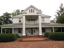 Wingate Town Hall | |
 Location of Wingate, North Carolina | |
| Coordinates: 34°59′6″N 80°26′50″W / 34.98500°N 80.44722°WCoordinates: 34°59′6″N 80°26′50″W / 34.98500°N 80.44722°W | |
| Country | United States |
| State | North Carolina |
| County | Union |
| Area | |
| • Total | 1.7 sq mi (4.4 km2) |
| • Land | 1.7 sq mi (4.4 km2) |
| • Water | 0.0 sq mi (0.0 km2) |
| Elevation | 587 ft (179 m) |
| Population (2010) | |
| • Total | 3,491 |
| • Estimate (2016)[1] | 3,915 |
| • Density | 2,100/sq mi (790/km2) |
| Time zone | UTC-5 (Eastern (EST)) |
| • Summer (DST) | UTC-4 (EDT) |
| ZIP code | 28174 |
| Area code(s) | 704 |
| FIPS code | 37-74760[2] |
| GNIS feature ID | 0997487[3] |
Wingate is a town in Union County, North Carolina and a suburb of the city of Charlotte. The population was 3,906 at the 2014 census.
History
The Wingate Commercial Historic District was listed on the National Register of Historic Places in 2014.[4]
Geography
Wingate is located at 34°59′6″N 80°26′50″W / 34.98500°N 80.44722°W (34.985021, -80.447254).[5]
According to the United States Census Bureau, the town has a total area of 1.7 square miles (4.4 km2), all of it land.
Demographics
| Historical population | |||
|---|---|---|---|
| Census | Pop. | %± | |
| 1910 | 353 | — | |
| 1920 | 470 | 33.1% | |
| 1930 | 526 | 11.9% | |
| 1940 | 541 | 2.9% | |
| 1950 | 793 | 46.6% | |
| 1960 | 1,304 | 64.4% | |
| 1970 | 2,569 | 97.0% | |
| 1980 | 2,615 | 1.8% | |
| 1990 | 2,821 | 7.9% | |
| 2000 | 2,406 | −14.7% | |
| 2010 | 3,491 | 45.1% | |
| Est. 2016 | 3,915 | [1] | 12.1% |
| U.S. Decennial Census[6] | |||
As of the census[2] of 2010, there were 3,491 people, 945 households, and 650 families residing in the town. The population density was 2053.5 people per square mile (793.4/km²). There were 1,046 housing units at an average density of 615.2 per square mile (237.7/km²). The racial makeup of the town was 60.6% White, 28.8% African American, 0.4% Native American, 0.9% Asian, 7.9% from other races, and 1.4% from two or more races. Hispanic or Latino of any race were 12.4% of the population.
There were 945 households out of which 30.7% had children under the age of 18 living with them, 44.2% were married couples living together, 19.5% had a female householder with no husband present, and 31.2% were non-families. 25.2% of all households were made up of individuals and 9.4% had someone living alone who was 65 years of age or older. The average household size was 2.66 and the average family size was 3.20.
In the town, the population was spread out with 20.0% under the age of 18, 35.0% from 18 to 24, 18.8% from 25 to 44, 17.5% from 45 to 64, and 8.4% who were 65 years of age or older. The median age was 22.5 years.
The median income for a household in the town was $41,774, and the median income for a family was $51,148. The per capita income for the town was $16,419. About 12.5% of the population were below the poverty line.
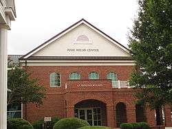
The town is known mainly for Wingate University and the Jesse Helms Center, K-Ci & JoJo and Walter Collin Burleson.
On February 26, 2018, the town made international news when a 55-year-old man later identified as Prentis Robinson was shot 4 times while streaming a Facebook live. Robinson had just left the Wingate Police Department moments earlier to report a stolen cell phone, and was known to out suspected drug dealers in the area. Wingate University and nearby Wingate Elementary School went on lockdown for over an hour after both reports of an active shooter on the college's campus and because of the proximity to the shooting, less than a half mile from the campus. The active shooter report proved to be false. One day later, 65-year-old Douglas Colson turned himself into the Union County Sheriff's Office after a warrant went out for his arrest.
References
- 1 2 "Population and Housing Unit Estimates". Retrieved June 9, 2017.
- 1 2 "American FactFinder". United States Census Bureau. Retrieved 2008-01-31.
- ↑ "US Board on Geographic Names". United States Geological Survey. 2007-10-25. Retrieved 2008-01-31.
- ↑ "National Register of Historic Places Listings". Weekly List of Actions Taken on Properties: 12/01/14 through 12/05/14. National Park Service. 2014-12-12.
- ↑ "US Gazetteer files: 2010, 2000, and 1990". United States Census Bureau. 2011-02-12. Retrieved 2011-04-23.
- ↑ "Census of Population and Housing". Census.gov. Retrieved June 4, 2015.
External links
- Official website of Wingate, NC
- Official website of the Wingate Fire Department
- Official website of Wingate University
- Official website of the Jesse Helms Center
Municipalities and communities of Union County, North Carolina, United States | ||
|---|---|---|
| City | 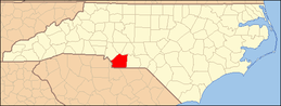 | |
| Towns | ||
| Villages | ||
| CDP | ||
| Unincorporated communities | ||
| Ghost town | ||
| Footnotes | ‡This populated place also has portions in an adjacent county or counties | |