Hohhot

.svg.png)


Hohhot, abbreviated in Chinese as Hushi, formerly known as Kweisui, is the capital of Inner Mongolia in the north of the People's Republic of China,[5][6] serving as the region's administrative, economic and cultural center.[7] Its population was 2,866,615 inhabitants at the 2010 census, of whom 1,980,774 lived in the built-up (or metro) area made up of 4 urban districts.[8]
The name of the city in Mongolian means "Blue City", although it is also wrongly referred to as the "Green City."[9] The color blue in Mongol culture is associated with the sky, eternity and purity. In Chinese, the name can be translated as Qīng Chéng (Chinese: 青城; literally: "Blue/Green City")[10] The name has also been variously romanized as Kokotan, Kokutan, Kuku-hoton, Huhohaot'e, Huhehot, Huhot, or Köke qota.[6]
History
Early history
During Warring States period, the area around Hohhot was part of Zhao state. In most time of Imperial China, Hohhot area was under control of Chinese dynasties and played an important role in defense against northern nomadic people' invasion.
Ming and Qing era
In 1557, the Tümed Mongol leader Altan Khan began building the Da Zhao Temple on the Tümed plain in order to convince the Ming dynasty (1368–1644) government of his leadership of the southern Mongol tribes.[11] The town that grew up around this temple was called the "Blue Town" (Kokegota in Mongolian). The Ming had been blockading the Mongols' access to Chinese iron, cotton, and crop seeds, in order to dissuade them from attacking the North China plain. In 1570, Altan Khan successfully negotiated the end of the blockade by establishing a vassal-tributary relationship with the Ming, who changed Kokegota's name to Guihua (traditional Chinese: 歸化; simplified Chinese: 归化; pinyin: Guīhuà; postal: Kweihua; literally: "Return to Civilization") in 1575. The population of Guihua grew to over 150,000 in the early 1630s as local Mongol princes encouraged the settlement of Han Chinese merchants. There were occasional attacks on Guihua by Mongol armies, such as the total razing of the city by Ligdan Khan in 1631. Altan Khan and his successors constructed temples and fortresses in 1579, 1602 and 1727. The Tümed Mongols of the area had long since adopted a semiagricultural way of life. Hui merchants gathered north of the gate of the city's fortress, building a mosque in 1693.[12] Their descendants formed the nucleus of the modern Huimin district.
After the Manchus founded the Qing dynasty (1644–1911), the Kangxi Emperor (reigned 1661–1722) sent troops to control the region,[9] which was of interest to the Qing as a center of study of Tibetan Buddhism. Just northeast of Guihua the Qing built the strong garrison town of Suiyuan (綏遠; 绥远; PRC Standard Mandarin: Suíyuǎn, Taiwanese Standard Mandarin: Suīyuǎn), from which they supervised the defense of southwestern Inner Mongolia against Mongol attacks from the north in 1735–39.[13]:13[14] Guihua and Suiyuan was merged into Shanxi province and became Guihua County (歸化縣; 归化县; Guīhuà Xiàn) of Qing China. French missionaries established a Catholic church in Guihua in 1874, but the Christians were forced to flee to Beijing during the antiforeign Boxer Rebellion of 1899–1901.
Republican era
In 1913, the government of the new Republic of China united the garrison town of Suiyuan and the old town of Guihua as Guisui (traditional Chinese: 歸綏; simplified Chinese: 归绥; pinyin: PRC Standard Mandarin: Guīsuí, ROC Standard Mandarin: Guīsuī; postal: Kweisui). Guisui town was the center of Guisui County (歸綏縣; 归绥县; PRC: Guīsuí Xiàn, ROC: Guīsuī Xiàn) and the capital of Suiyuan Province in northern China. A bubonic plague outbreak in 1917 and the connection of Guisui to railway links in Shanxi, Shaanxi, Hebei, and Beijing helped renew the economy of Guisui town by forming links with eastern China and western China's Xinjiang province.[13]:15 In 1918, the American specialist on Inner Asia Owen Lattimore noted Guisui's ethnic composition as "a town purely Han Chinese except for the Lama monasteries ... the Tümeds are now practically nonexistent and the nearest Mongolians are to be sought at 50 or 60 miles distance on the plateau."[13]:15 During the progressive Japanese invasion of China in the 1930s, the Japanese created the puppet state of Mengjiang headed by Prince De, who renamed Guisui "Blue City" ("Hohhot"(Chinese: 厚和) or Huheshi).[15] After the surrender of Japan in 1945, the Republic of China changed the name back to Guisui.[13]:16 The Communist Party of China's forces drove out General Fu Zuoyi, the Republic's commander in Suiyuan, during the Chinese Civil War, and after the Chinese Revolution in 1949, Guisui was renamed Hohhot.[13]:16
People's Republic era
During the Civil War, in order to gain the support of separatist Mongols, the Communists established the Inner Mongolia Autonomous Region in Mongol-minority areas of the Republic's provinces of Suiyuan, Xing'an, Chahar, and Rehe. Guisui was chosen as the region's administrative centre in 1952, replacing Zhangjiakou. In 1954, after establishment of the People's Republic of China, the city was renamed from Guisui to Hohhot, though with a different Chinese pronunciation of Huhehaote.[13]:16
The city has seen significant development since China's reform and opening began. The city's far east side began development around 2000 and is now home to the municipal government, most of the Autonomous Region's administrative buildings,[16] an artificial lake called Ruyi He,[17] and a large number of condominiums, mostly built by the local real estate company Gold Horse International Inc. The Hohhot City Stadium, built on the city's north side, was finished in 2007.[18]
A city with a rich cultural background, Hohhot is known for its historical sites and temples and is one of the major tourist destinations of Inner Mongolia. It is also nationally known as the home of China's dairy giants Mengniu and Yili,[19][20] and was declared "Dairy Capital of China" by the China Dairy Industry Association and the Dairy Association of China in 2005.
Geography

Located in the south central part of Inner Mongolia, Hohhot is encircled by the Daqing Shan (Chinese: 大青山; literally: "Great blue Mountains") to the north and the Hetao Plateau to the south.[21]
Climate
Hohhot features a cold semi-arid climate (Köppen BSk), marked by long, cold, and very dry winters; hot, somewhat humid summers; strong winds (especially in spring); and monsoonal influence. The coldest month is January, with a daily mean of −11.6 °C (11.1 °F), while July, the hottest month, averages 22.6 °C (72.7 °F). The annual mean temperature is 6.73 °C (44.1 °F), and the annual precipitation is 398 millimetres (15.7 in), with more than half of it falling in July and August alone. Variability can be very high, however: in 1965 Hohhot recorded as little as 155.1 mm (6.11 in) but six years before that, as much as 929.2 mm (36.58 in), of which over a third (338.6 mm (13.33 in)) only in July.[22]
Hohhot is a popular destination for tourists during the summer months because of the nearby Zhaohe grasslands. More recently, due to desertification, the city sees sandstorms on almost an annual basis. With monthly percent possible sunshine ranging from 58 percent in July to 71 percent in October, sunshine is abundant year-round, the city receives 2,862 hours of bright sunshine annually. Extreme temperatures have ranged from −32.8 °C (−27 °F) to 38.9 °C (102 °F).[23]
| Climate data for Hohhot (1971–2000) | |||||||||||||
|---|---|---|---|---|---|---|---|---|---|---|---|---|---|
| Month | Jan | Feb | Mar | Apr | May | Jun | Jul | Aug | Sep | Oct | Nov | Dec | Year |
| Record high °C (°F) | 8.0 (46.4) |
17.0 (62.6) |
19.4 (66.9) |
33.4 (92.1) |
35.0 (95) |
35.7 (96.3) |
38.5 (101.3) |
36.8 (98.2) |
32.4 (90.3) |
26.5 (79.7) |
20.4 (68.7) |
11.6 (52.9) |
38.9 (102) |
| Average high °C (°F) | −5 (23) |
−0.4 (31.3) |
7.0 (44.6) |
16.3 (61.3) |
23.2 (73.8) |
27.3 (81.1) |
28.5 (83.3) |
26.4 (79.5) |
21.2 (70.2) |
14.1 (57.4) |
4.4 (39.9) |
−3.2 (26.2) |
13.3 (55.9) |
| Daily mean °C (°F) | −11.6 (11.1) |
−7.2 (19) |
0.3 (32.5) |
9.0 (48.2) |
16.1 (61) |
20.7 (69.3) |
22.6 (72.7) |
20.6 (69.1) |
14.6 (58.3) |
7.0 (44.6) |
−2.1 (28.2) |
−9.4 (15.1) |
6.7 (44.1) |
| Average low °C (°F) | −16.8 (1.8) |
−12.8 (9) |
−5.5 (22.1) |
1.6 (34.9) |
8.2 (46.8) |
13.3 (55.9) |
16.4 (61.5) |
14.8 (58.6) |
8.3 (46.9) |
1.0 (33.8) |
−7 (19) |
−14.2 (6.4) |
0.6 (33.1) |
| Record low °C (°F) | −30.5 (−22.9) |
−29.4 (−20.9) |
−19.4 (−2.9) |
−11.5 (11.3) |
−3.5 (25.7) |
2.3 (36.1) |
8.3 (46.9) |
4.6 (40.3) |
−2.0 (28.4) |
−10.1 (13.8) |
−20.2 (−4.4) |
−26.4 (−15.5) |
−32.8 (−27) |
| Average precipitation mm (inches) | 2.6 (0.102) |
5.2 (0.205) |
10.2 (0.402) |
13.5 (0.531) |
27.6 (1.087) |
47.2 (1.858) |
106.5 (4.193) |
109.1 (4.295) |
47.4 (1.866) |
20.7 (0.815) |
6.2 (0.244) |
1.8 (0.071) |
398.0 (15.669) |
| Average precipitation days (≥ 0.1 mm) | 2.5 | 2.8 | 3.4 | 3.7 | 6.0 | 8.9 | 12.9 | 12.7 | 8.3 | 4.5 | 2.4 | 1.8 | 69.9 |
| Average relative humidity (%) | 58 | 52 | 46 | 37 | 39 | 47 | 61 | 66 | 62 | 59 | 59 | 59 | 54 |
| Mean monthly sunshine hours | 180.7 | 198.3 | 245.5 | 268.6 | 294.5 | 291.3 | 264.9 | 255.2 | 252.1 | 244.8 | 195.3 | 171.0 | 2,862.2 |
| Percent possible sunshine | 61 | 66 | 67 | 68 | 66 | 65 | 58 | 60 | 68 | 71 | 66 | 60 | 65 |
| Source #1: China Meteorological Administration[24] | |||||||||||||
| Source #2: Weather China[25] | |||||||||||||
Administrative divisions
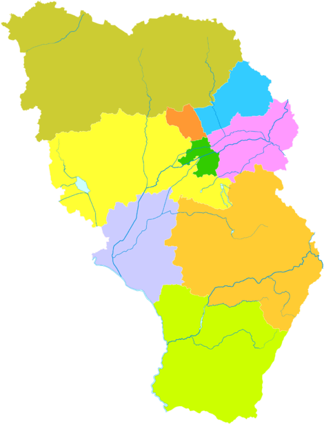
The city is administratively at the prefecture-level, meaning that it administers both its urban area and the rural regions in its vicinity. The administrative area includes 4 counties, 4 districts, and a county-level banner; they are further divided into 20 urban sub-districts, and 96 townships. The data here represented is in km² and uses data from the 2010 Census.
| Map | |||||||
|---|---|---|---|---|---|---|---|
| English Name | Mongolian | Simplified Chinese | Pinyin | Area | Population | Density | |
| City Proper | |||||||
| Huimin District (Hodong'arad District) |
ᠬᠣᠳᠣᠩ ᠠᠷᠠᠳ ᠤᠨ ᠲᠣᠭᠣᠷᠢᠭ (Qotoŋ Arad-un toɣoriɣ) |
回民区 | Huímín Qū | 194.4 | 394,555 | 2,030 | |
| Xincheng District (Xinhot District) |
ᠰᠢᠨᠡ ᠬᠣᠲᠠ ᠲᠣᠭᠣᠷᠢᠭ (Sin-e Qota toɣoriɣ) |
新城区 | Xīnchéng Qū | 660.6 | 567,255 | 859 | |
| Yuquan District | ᠢᠤᠢ ᠴᠢᠤᠸᠠᠨ ᠲᠣᠭᠣᠷᠢᠭ (Iui čiuvan toɣoriɣ) |
玉泉区 | Yùquán Qū | 207.2 | 383,365 | 1,850 | |
| Saihan District | ᠰᠠᠶᠢᠬᠠᠨ ᠲᠣᠭᠣᠷᠢᠭ (Sayiqan toɣoriɣ) |
赛罕区 | Sàihǎn Qū | 1,002.9 | 635,599 | 634 | |
| Rural | |||||||
| Togtoh County | ᠲᠣᠭᠲᠠᠬᠤ ᠰᠢᠶᠠᠨ (Toɣtaqu siyan) |
托克托县 | Tuōkètuō Xiàn | 1,407.8 | 200,840 | 143 | |
| Wuchuan County | ᠦᠴᠤᠸᠠᠨ ᠰᠢᠶᠠᠨ (Üčuvan siyan) |
武川县 | Wǔchuān Xiàn | 4,682.3 | 108,726 | 23 | |
| Horinger County | ᠬᠣᠷᠢᠨ ᠭᠡᠷ ᠰᠢᠶᠠᠨ (Qorin Ger siyan) |
和林格尔县 | Hélíngé'ěr Xiàn | 3,447.8 | 169,856 | 49 | |
| Qingshuihe County | ᠴᠢᠩ ᠱᠦᠢ ᠾᠧ ᠰᠢᠶᠠᠨ (Čiŋ šüi hė siyan) |
清水河县 | Qīngshuǐhé Xiàn | 2,859 | 93,887 | 33 | |
| Tumed Left Banner (Tumed Jun Banner) |
ᠲᠦᠮᠡᠳ ᠵᠡᠭᠦᠨ ᠬᠣᠰᠢᠭᠤ (Tümed Jegün qosiɣu) |
土默特左旗 | Tǔmòtè Zuǒ Qí | 2,765 | 312,532 | 113 | |
Demographics
| Historical population | ||
|---|---|---|
| Year | Pop. | ±% |
| 1953 | 792,600 | — |
| 1964 | 1,118,600 | +41.1% |
| 1982 | 1,645,200 | +47.1% |
| 1990 | 1,911,600 | +16.2% |
| 2000 | 2,437,900 | +27.5% |
| 2010 | 2,866,600 | +17.6% |
| Population size may be affected by changes on administrative divisions. | ||
The urban population of Hohhot has increased rapidly since the 1990s. According to the 2010 Census, the population of Hohhot had reached 2,866,615 people, 428,717 more inhabitants than in 2000 (the average annual demographic growth for the period 2000–2010 was of 1.63 percent).[8][26] Its built-up (or metro) area is home to 1,980,774 inhabitants (4 urban districts).
The majority of the population of Hohhot are Han Chinese, representing 87.16 percent of the total population in 2010. Most Han in Hohhot, if their ancestry is traced several decades back, have ancestors from Shanxi, northeast China, or Hebei. Most Mongols in the city speak Chinese. A 1993 survey conducted by Inner Mongolia University found that only 8 percent of Tümed Mongols (the majority tribe in Hohhot) could speak the Mongolian language.[13]:15 A significant portion of the population is of mixed ethnic origin. According to the anthropologist William Jankowiak, author of the book Sex, Death, and Hierarchy in a Chinese City (1993), there is "relatively little difference between minority culture and Han culture" in Hohhot, with differences concentrating around relatively minor attributes such as food and art, and similarities abounding over fundamental issues of ethics, status, life goals, and worldview.[13]:5
Ethnic groups in Hohhot, according to the 2000 census, were:
| Ethnicity | Population | Percentage |
|---|---|---|
| Han Chinese | 2,115,888 | 88.42% |
| Mongol | 204,846 | 8.56% |
| Hui Chinese | 38,417 | 1.61% |
| Manchu | 26,439 | 1.10% |
| Daur | 2,663 | 0.11% |
| Korean | 1,246 | 0.05% |
| Miao | 443 | 0.02% |
Economy
Hohhot is a major industrial center within Inner Mongolia. Together with Baotou and Ordos, it accounts for more than 60 percent of the total industrial output of Inner Mongolia.[27] After Baotou and Ordos, it is the third-largest economy of the province, with GDP of RMB 247.56 billion in 2012, up 11.0 percent year on year.[4] Hohhot accounted for approximately 15.5 percent of the province's total GDP in 2012.[28] It is also the largest consumer center in the region, recording ¥102.2 billion retail sales of consumer goods in 2012, an increase of 14.9 percent from 2011.[4] The city has been a central developmental target for the China Western Development project being pursued by the Central Government. There are many famous enterprises located in Hohhot, including China's largest dairy producer by sales revenue, the Inner Mongolia Yili Industrial Group, and the China Mengniu Dairy Co.[29][30]
As the economic center of Inner Mongolia, Hohhot's urban area has expanded greatly since the 1990s. CBDs have grown rapidly in all the city's major districts. The completion of a new office tower for the Municipal Government in Eastern Hohhot marked a shift of the city center to the east. Hailiang Plaza (海亮广场), a 41-floor tower constructed in the city center, became one of the few notable department stores for luxury merchandise in the city.
Major Development Zones
- Hohhot Economic and Technological Development Zone
- Hohhot Export Processing Zone
Culture

Due to its relatively diverse cultural make-up, and despite its characteristics as a mid-sized Chinese industrial city, the Hohhot street scene has no shortage of ethnic minority elements. Tongdao Road, a major street in the old town area, is decorated with Islamic and Mongol exterior designs on all its buildings. A series of government initiatives in recent years have emphasized Hohhot's identity with ethnic minority groups, especially in increasing Mongol-themed architecture around the city. By regulation, all street signs and public transportation announcements are in both Chinese and Mongolian.[31]
Dialect
Older Hohhot residents mostly tend to converse in the Hohhot dialect, a branch of the Jin language from neighbouring Shanxi province. This spoken form can be difficult to understand for speakers of other Mandarin Chinese dialects. The newer residents, mostly concentrated in Xincheng and Saihan Districts, speak Hohhot-based Mandarin, the majority also with a noticeable accent and some unique vocabulary.
Cuisine
Food specialty in the area is mostly focused on Mongol cuisine and dairy products. Commercially, Hohhot is known for being the base of the nationally renowned dairy giants Yili and Mengniu. The Mongol drink suutei tsai ("naicha" 奶茶 in Chinese, "milk tea" in English), has become a typical breakfast selection for anyone living in or visiting the city.[32] The city also has rich traditions in the making of hot pot and shaomai, a type of traditional Chinese dumpling served as dim sum.[33]
Transport
Airport
Hohhot's Baita International Airport (IATA:HET) is located about 14.3 km (8.9 mi) east of the city centre by car. It has direct flights to larger domestic cities including Beijing, Tianjin,[34] Shanghai, Shenzhen, Chengdu, and others. It also has international flights to Taichung,[35] Hong Kong, and Ulaanbaatar, Mongolia.
Railway
Hohhot lies on the Jingbao Railway from Beijing to Baotou, and is served by two railway stations: Hohhot Railway Station and Hohhot East Railway Station.[36] The line began operation in 1921.[37] Trains to Beijing link to destinations to the south and the northeast. The most prominent rail link with Beijing is the overnight K90 train, which has served the Hohhot-Beijing line since the 1980s and is referred to colloquially as the "9-0". Westbound trains go through Baotou and Lanzhou. There are also rail links to most major Inner Mongolian cities and to Ulaanbaatar, Mongolia.
Because the quickest trip to Beijing takes around six and a half hours despite the relatively close proximity of the two cities, plans for high-speed rail were discussed extensively prior to the construction of a high-speed railway station beginning in 2008. The station was completed in 2011 and initially serviced only ordinary lines. In January 2015, CRH opened its first D-series (dongchezu) route in Inner Mongolia in the Baotou-Hohhot-Jining corridor, shortening travel time between Inner Mongolia's two largest cities to a mere 50 minutes.[38] This line reached a maximum speed of 200 km/h (124 mph) between Hohhot and Baotou. Another high-speed rail line linking Hohhot to Zhangjiakou and the planned Beijing-Zhangjiakou railway are due for completion in 2017, and are designed to operate at 250 km/h (155 mph). The section between Hohhot and Ulanqab (Jining) opened in August 2017; travel time between the two cities was shortened to 40 minutes.[39]
Expressways
An expressway built in 1997 (then known as the Hubao Expressway) links Hohhot with Baotou. In recent years this expressway has been expanded eastwards to Jining and Zhangjiakou, and on to Beijing as part of the G6 Beijing–Lhasa Expressway (Jingzang Expressway). The city is on the route of China National Highway 110, which runs from Yinchuan to Beijing. China National Highway 209 begins in Hohhot and carries traffic southbound towards southern China, with its terminus in Guangxi. Hohhot is connected to its northern counties by the Huwu Highway, which was completed in 2006. Previously, travel to the northern counties had required lengthy navigation through mountainous terrain.
Long distance buses connect Hohhot to outlying counties, the cities of Baotou, Wuhai, and Ordos, and other areas in Inner Mongolia.
Public transport
Hohhot's major north–south thoroughfares are called roads (Lu) and its east–west thoroughfares are called streets (Jie). This is roughly equivalent to dividing roads into "street" and "avenue" designations according to direction, as practiced in many North American cities. The largest elevated interchange is near the site of the city's Drum Tower (Gulou), after which it is named. Several major streets are named after Inner Mongolian leagues and cities; among these, Hulun Buir, Jurim (now Tongliao), Juud (Now Chifeng), Xilin Gol, and Xing'an run north–south, while Bayannaoer, Hailar, Ulanqab, and Erdos run east–west.
The city's public transit system is composed of nearly one hundred bus routes and a large fleet of taxicabs, which are normally green or blue. Bus fare is 1 yuan; taxi fares begin at 8 yuan.
Education
Universities located in Hohhot include:
- Inner Mongolia University of Finance and Economics
- Inner Mongolia University, only 211 Project University in Inner Mongolia.[40]
- Inner Mongolia University of Agriculture
- Inner Mongolia Normal University
- Inner Mongolia University of Technology
- Inner Mongolia College of Medicine
- Inner Mongolia College of Finance and Economics
- Hohhot College of Education
- Hohhot College of Police
- Honder College of Inner Mongolia Normal University
High Schools located in Hohhot include:
- Hohhot No.2 Middle School
- Affiliated Middle School to Inner Mongolia Normal University
Sports
Hohhot lacked a professional soccer team until Shenyang Dongjin F.C. relocated to Hohhot, changing their name to Hohhot Dongjin, in 2012.[41] They played at Hohhot City Stadium, which was newly built in 2007.[42] The club finished in the bottom of the league in the 2012 season and was and relegated to League Two. After playing half a season at Hohhot in 2013, the team relocated to Liaoning and chose Benxi City Stadium as their new home court.[43]
On 14 January 2015, Taiyuan Zhongyou Jiayi F.C. moved to Hohhot and changed their name to Nei Mongu Zhongyou F.C.[44] The team play in China League One and chose Hohhot City Stadium as their home in 2015. The team had been first established as Shanxi Jiayi F.C. on 8 October 2011.[45]
Notable landmarks
There were over 50 Ming and Qing Buddhist temples and towers in Guihua and Suiyuan.
- Zhaojun Tomb (昭君墓), located about nine kilometers south of the city center. It is said to be the tomb of Wang Zhaojun, a woman of the Han Empire who married a Xiongnu Chanyu (king).
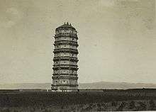
- Baita Pagoda (白塔), located in the eastern rarual area nearing the airport. It was constructed during the Liao Dynasty. The airport of Hohhot is named after Baita Pagoda.
- Da Zhao Temple (大召), located in the centre of Guihua town. It was constructed in the Northern Yuan Dynasty and is the oldest Buddhist lama monastery in the city.[46]
- Temple of the Five Pagodas (五塔寺), located in the eastern part of Guihua town. It was completed in the Qing Dynasty, with architecture very similar to that of Indian temples.[32] On its walls there are more than 1,500 figures of Buddha.
- Residence of Gurun Princess Kejing (固倫恪靖公主府), located at the foot of Yinshan Mountain. It was the mansion of Gurun Princess Kejing of the Qing Dynasty, who was married to a Mongol prince.
- Residence of the General (將軍衙署), located in the centre of Suiyuan town. It was the residence and office building of Suiyuan Generals of the Qing Dynasty.
- Great Mosque of Hohhot (清真大寺), located out of the northern gate of Guihua town. It was constructed during the Qing Dynasty.
- Inner Mongolia Museum (內蒙古博物院). Main exhibits include dinosaur fossils, historical artifacts of nomadic peoples, and the cultural life of modern nomadic peoples.
- Qingcheng Park (青城公園), formerly People's Park, in the city center[47]
 The sculpture of "Milk Capital" symbol
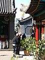 Great Mosque of Hohhot
See also
Footnotes
- Explanatory notes
- Citations
- ↑ Cox, W (2018). Demographia World Urban Areas. 14th Annual Edition (PDF). St. Louis: Demographia. p. 22.
- 1 2 城市概况 (in Chinese). City of Hohhot. April 12, 2013.
- ↑ Cox, W (2018). Demographia World Urban Areas. 14th Annual Edition (PDF). St. Louis: Demographia. p. 22.
- 1 2 3 呼和浩特市2012年国民经济和社会发展统计公报. Hohhot Municipal Bureau of Statistics (in Chinese). 1 April 2013. Retrieved 17 July 2015.
- ↑ "Illuminating China's Provinces, Municipalities and Autonomous Regions". PRC Central Government Official Website. 2001. Retrieved 2014-05-28.
- 1 2 Solovʹev, Sergeĭ Mikhaĭlovich (1998), History of Russia, 23, Academic International Press, p. 178
- ↑ The New Encyclopædia Britannica, 15th Edition (1977), Vol. I, p. 275.
- 1 2 彤, 王. "呼和浩特市2010年第六次全国人口普查主要数据". 内蒙古新闻网. 内蒙古日报. Retrieved 13 July 2015.
- 1 2 Perkins (1999), p. 212.
- ↑ Chinese "qing" has traditionally been a color between "blue" and "green" in English, leading some modern sources to translate Qing Cheng into English as "Green City" instead of "Blue City," including, for example, the official website of Hohhot.
- ↑ "Dazhao Temple". Travel China Guide. Retrieved 12 January 2013.
- ↑ Zhang, Guanglin (2005). Islam in China. 五洲传播出版社. p. 75. ISBN 978-7-5085-0802-3. Retrieved 29 August 2012.
- 1 2 3 4 5 6 7 8 Jankowiak, William R (1993). Sex, Death, and Hierarchy in a Chinese City: An Anthropological Account. Columbia University Press. pp. 5, 11–16.
- ↑ Traditional dwellings and settlements review: journal of the International Association for the Study of Traditional Environments. International Association for the Study of Traditional Environments. 1998. p. 12. Retrieved 29 August 2012.
- ↑ Lin, Hsiao-ting (2010), Modern China's Ethnic Frontiers: A Journey to the West, Taylor and Francis, pp. 43, 49, ISBN 9780415582643
- ↑ Wasserman, Adam. "Gold Horse International, Inc. Updates Status of Key Real Estate Development Projects for 2009". Gale, Cengage Learning. PR Newswire Association LLC. Retrieved 20 July 2015.
- ↑ Inc|url=http://www.realpennies.com/otc/GHII/%7Cwebsite=realpennies%7Caccessdate=20 July 2015}}
- ↑ 内蒙古新建呼和浩特市体育场落成 可容纳近6万人 - 新农村商网
- ↑ "Background of Inner Mongolia Yili Industrial Group Co., Ltd". Archived from the original on 1 January 2007. Retrieved 20 July 2015.
- ↑ "Profile of Inner Mongolia Yili Industrial Group Company Limited". Archived from the original on 26 June 2008. Retrieved 20 July 2015.
- ↑ Encyclopedia Americana. Grolier Incorporated. April 2001. p. 510. ISBN 978-0-7172-0134-1. Retrieved 29 August 2012.
- ↑ Huhehaote rainfall
- ↑ 中国气象科学数据共享服务网 Archived 2 March 2015 at the Wayback Machine.
- ↑ 中国地面国际交换站气候标准值月值数据集(1971-2000年) (in Chinese). China Meteorological Administration. Archived from the original on 21 September 2013. Retrieved 17 March 2009.
- ↑ 呼和浩特城市介绍以及气候背景分析. 中国天气网 (in Chinese). 中国气象局公共气象服务中心. Retrieved 27 July 2015.
- ↑ (in Chinese) Compilation by LianXin website. Data from the Sixth National Population Census of the People's Republic of China Archived 22 June 2011 at the Wayback Machine.
- ↑ 鄂尔多斯人均GDP超北京 房产业面临何种机遇 (in Chinese).
- ↑ "hktdc.com – Profiles of China Provinces, Cities and Industrial Parks". Tdctrade.com. Retrieved 1 February 2014.
- ↑ "Programa Conjunto FAO/OMS Sobre Normas Alimentarias" (Archive). Food and Agriculture Organization. p. 30. Retrieved on July 10, 2014. "Inner Mongolia Yili Industrial Group Co. Ltd. No. 8, Jinsi Road, Jinchun Developing Zone 010080 Hohhot P.R. China"
- ↑ Yili, Mengniu, Bright Dairy lose their status as 'national brands', China Central Television (22 September 2008)
- ↑ "呼和浩特市社会市面蒙汉两种文字并用管理办法". 中华人民共和国国家民族事务委员会. Retrieved 13 July 2015.
- 1 2 Lonely Planet. Níngxià and Inner Mongolia – Guidebook Chapter. Lonely Planet. p. 25. ISBN 978-1-74321-265-3. Retrieved 29 August 2012.
- ↑ Hsiung, Deh-Ta. Simonds, Nina. Lowe, Jason. [2005] (2005). The food of China: a journey for food lovers. Bay Books. ISBN 978-0-681-02584-4. p 38.
- ↑ "春运开始后"天津-呼和浩特-阿拉善左旗"航线成为热点(in Chinese)". 无锡物流. 28 January 2014. Retrieved 28 January 2014.
- ↑ "台湾远东航空看好内蒙古下月开通呼和浩特航线(in Chinese)". sina.com.cn. 28 April 2014. Retrieved 28 April 2014.
- ↑ Zhongguo dui wai jing ji mao yi nian jian bian ji wei yuan hui (1993). Almanac of China's foreign economic relations and trade. Hua run mao yi zi xun you xian gong si. p. 945. Retrieved 29 August 2012.
- ↑ 外观宏伟造型独特 呼和浩特东站完美初现. Xinhua News Inner Mongolia. 2008-09-23. Archived 3 March 2016 at the Wayback Machine.(in Chinese)
- ↑ 呼和浩特正式跨入"动车"时代. Inner Mongolia Xinhua. January 9, 2015.
- ↑ 呼张客专开土动工,方便进京之路 (in Chinese). China Railways. Retrieved 12 November 2014.
- ↑ "Inner Mongolia University: A survey of the university". Inner Mongolia University. Archived from the original on 26 February 2009. Retrieved 12 March 2009.
- ↑ 东进更名主场落户呼和浩特 老总:只是换了个名字
- ↑ 内蒙古新建呼和浩特市体育场落成 可容纳近6万人 - 新农村商网
- ↑ "呼和浩特东进终于返乡 未来中乙主场设辽宁本溪". 沈阳晚报. 25 July 2013. Retrieved 13 July 2015.
- ↑ 关于太原中优嘉怡足球俱乐部有限公司工商迁移并更名的公示 (in Chinese)
- ↑ 山西嘉怡足球俱乐部在并成立 Archived 4 November 2014 at the Wayback Machine.(in Chinese)
- ↑ 大召寺(in Chinese)
- ↑ 记忆中的呼市人民公园 [Hohhot People's Park] (in Chinese). Hohhot News. 2014-02-24. Retrieved 2014-05-02.
Bibliography
- Perkins (1999). Encyclopedia of China: The Essential Reference to China, Its History and Culture. Dorothy Perkins. 1st paperback edition: 2000. A Roundtable Press Book, New York, N.Y. ISBN 0-8160-4374-4 (pbk).
External links
| Wikimedia Commons has media related to Hohhot. |
- Hohhot government website (in simplified Chinese)
- Hohhot government website (in Mongolian)

Inner Mongolia topics | |
|---|---|
| General | |
| Geography | |
| Education | |
| Culture | |
| Cuisine | |
| Visitor attractions | |
| |
Major cities along the Yellow River | ||
|---|---|---|
| Province-level subdivisions | Cities (from upper reaches to lower reaches) | 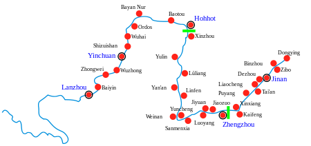 |
| Gansu | ||
| Ningxia | ||
| Inner Mongolia | ||
| Shanxi | ||
| Shaanxi | ||
| Henan | ||
| Shandong | ||
Major cities along the Pearl River · Major cities along the Yangtze River | ||
| Authority control |
|---|