Qianjiang, Hubei
| Qianjiang 潜江市 | |
|---|---|
| County-level & Sub-prefectural city | |
.png) Location of Qianjiang City jurisdiction in Hubei | |
| Coordinates: 30°24′N 112°54′E / 30.400°N 112.900°ECoordinates: 30°24′N 112°54′E / 30.400°N 112.900°E | |
| Country | People's Republic of China |
| Province | Hubei |
| Area | |
| • County-level & Sub-prefectural city | 2,004 km2 (774 sq mi) |
| • Urban (2018)[1] | 62 km2 (24 sq mi) |
| Elevation | 32 m (105 ft) |
| Population (1999) | |
| • County-level & Sub-prefectural city | 998,525 |
| • Density | 500/km2 (1,300/sq mi) |
| • Urban (2018)[2] | 520,000 |
| • Urban density | 8,400/km2 (22,000/sq mi) |
| Time zone | UTC+8 (China Standard) |
| Website | 潜江市人民政府门户网站 (translation: Qianjiang City People's Government Web Portal) (in Simplified Chinese) |
Qianjiang (simplified Chinese: 潜江; traditional Chinese: 潛江; pinyin: Qiánjiāng) is a sub-prefecture-level city of south-central Hubei province, People's Republic of China.
Geography and climate
Qianjiang is located in south-central Hubei province in the Jianghan Plain. Its area is 2,004 square kilometres (774 sq mi)
Qianjiang's climate is temperate. Average annual temperature is 17 °C (63 °F).
There were many small lakes, ponds, and rivers scattered around the Qianjiang area. However, starting in the early 80's most of them disappeared due to urbanization and industrialization.
Administrative divisions
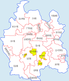
Qianjiang had 15 towns, 1 economic development zone, and 6 management areas. As of 2016, Qianjiang administers:[3][4]
| # | Name | Chinese (S) | ||||
|---|---|---|---|---|---|---|
| Subdistricts | ||||||
| 1 | Yuanlin Subdistrict Park | 园林街道 | ||||
| 2 | Guanghua Subdistrict | 广华街道 | ||||
| 3 | Yanghi Subdistrict | 杨市街道 | ||||
| 4 | Zhouji Subdistrict Zhou Rock | 周矶街道 | ||||
| 5 | Taifeng Subdistrict | 泰丰街道 | ||||
| former | Mianhua Seed Stock Station (now part of Taifeng) | 棉花原种场 | ||||
| 6 | Gaochang Subdistrict | 高场街道 | ||||
| Towns | ||||||
| 7 | Xiongkou Town | 熊口镇 | ||||
| 8 | Zhugentan Town | 竹根滩镇 | ||||
| 9 | Gaoshibei Town | 高石碑镇 | ||||
| 10 | Laoxin Town Old new | 老新镇 | ||||
| 11 | Wangchang Town | 王场镇 | ||||
| 12 | Yuyang Town | 渔洋镇 | ||||
| 13 | Longwan Town | 龙湾镇 | ||||
| 14 | Haokou Town | 浩口镇 | ||||
| 15 | Jiyukou Town | 积玉口镇 | ||||
| 16 | Zhangjin Town | 张金镇 | ||||
| Other Areas | ||||||
| 17 | Qianjiang Development Zone/Zekou Subdistrict | 潜江开发区/泽口街道 | ||||
| 18 | Bailuhu Administrative Area Egret Lake | 白鹭湖管理区 | ||||
| 19 | Zongkou Administrative Area | 总口管理区 | ||||
| 20 | Xiongkou Farm Administrative Area | 熊口农场管理区 | ||||
| 21 | Yunlianghu Administrative Area | 运粮湖管理区 | ||||
| 22 | Houhu Administrative Area | 后湖管理区 | ||||
| 23 | Zhouji Administrative Area | 周矶管理区 | ||||
| 24 | Jianghan Oil Administrative Area | 江汉石油管理局 | ||||
Transport
History
Qianjiang became a county in 965 during the Song dynasty. It was the early center of the Chu State.
Qianjiang was occupied by the Japanese during the Sino-Japan War. The Japanese primarily used prominent local Chinese to run the "puppet" government, notably many members of the Zhang family.
The communists from 1949 to early 1980s constructed a pharmaceutical plant, a textile factory, a book-printing factory, a large oil-and-gas drilling field, and other industrial installations in the Qianjiang area. As the national economic reform took force beginning in the late 1970s many of these state-run businesses went under.
Qianjiang was rarely ranked no. 1 in any way. However, during the period of 1959 and 1962, the largest "Cadre Camp" in China, or in the world as people at that time liked to call it, was established in Qianjiang. It was a result of the potential Sino-Russian War. The China-Russian relationship just broke up and military conflict was taking place in northern Chinese border with Russia. The Chinese government was afraid that a total war was about to break out against the Soviet. So they dispersed a lot of people and resources throughout the country. The young college graduates were sent to local Cadre Camps to train and entrench. This was the so-called "Priority 1 Order" given by Vice Chairman Lin Biao and planned by Chairman Mao.
The young cadres in Qianjiang worked hard to improve the agricultural situation. E.g., there was an ancient lake of hundreds of acres in the Qianjiang area. They drained the lake and converted it to farming land. From today's perspective, it was a wrong action that caused damage to the nature and eco-system, which in turn affected negatively the agricultural environment and cycle.
Qianjiang was well known for abundant local produces. Prominent local produces include duck eggs and lily seeds. They were so abundant that the produces were often sold at a nominal price. However, around the year of 1960, Qianjiang didn't escape the fate of most Chinese towns and was swept by an extended famine that was grossly caused by the political destruction of the fundamental aspects of the economy (production, supply-chain, and ownership). Many in Qianjiang were starved to death.
People from Qianjiang and surrounding areas, compared with people from the rest of the Hubei Province, have a reputation for being generous, gentle, and sincere. Prior to the modern days, Qianjiang demonstrated traditional, agriculture-based, Chinese ethos. E.g., if the farmers consider a water buffalo has been hard-working and loyal they would not slaughter it. But rather they would wait until it ages and dies. Then they would bury it and then build it a tomb.
There was a labor camp during the communist era in the Qianjiang area. The conditions at the camp were harsh. People would often sneak out to seek additional food. However, they never attempted to escape because it was impossible to hide in any place during those decades. Every town was tightly controlled and monitored by the government. No one would provide a stranger shelter and would only report him immediately to the local government.
Demographics
Qianjiang's population is just over 1 million.
Economy
Qianjiang has an important oil field, Jianghan Oil Field. It's part of the Sinopec Corporation.[5] Qianjiang has the potential of producing 200 million tons of oil, more than 9000 m3 of natural gas, and 800 billion tons of rock salt.
External links
References
- ↑ Cox, W (2018). Demographia World Urban Areas. 14th Annual Edition (PDF). St. Louis: Demographia. p. 22.
- ↑ Cox, W (2018). Demographia World Urban Areas. 14th Annual Edition (PDF). St. Louis: Demographia. p. 22.
- ↑ "行政区划" (in Simplified Chinese). 潜江市人民政府信息中心. 4 May 2016. Retrieved 30 December 2017.
潜江辖6个办事处、10个镇、6个管理区(农场)、1 个省级经济开发区。 街道办事处:园林办事处、广华办事处、杨市办事处、周矶办事处、泰丰办事处、高场办事处 乡镇:熊口镇、竹根滩镇、高石碑镇、老新镇、王场镇、渔洋镇、龙湾镇、浩口镇、积玉口镇、张金镇 管理区:白鹭湖管理区、总口管理区、熊口农场管理区、运粮湖管理区、后湖管理区、周矶管理区 省级经济开发区:潜江开发区 经省人民政府批准,省民政厅正式发文,潜江市棉花原种场改设为潜江市泰丰办事处,杨市办事处莫市等九个村和园林办事处小南门社区同时划归泰丰办事处,该处成为该市第十六个乡镇办事行政机关。
- ↑ "潜江市历史沿革 (translation: The Historical Development of Qianjiang City)" (in Simplified Chinese). 行政区划网站 (translation: Administrative Divisions Website). 8 July 2014. Retrieved 30 December 2017.
2010年第六次人口普查,潜江市常住总人口946277人,其中:园林街道139393人,杨市街道43365人,周矶街道38937人,广华街道7687人,竹根滩镇61372人,渔洋镇49116人,王场镇42370人,高石碑镇40784人,熊口镇44443人,老新镇53600人,浩口镇57015人,积玉口镇34966人,张金镇58560人,龙湾镇39258人,江汉石油管理局86439人,潜江经济开发区21797人,周矶管理区10462人,后湖管理区24651人,熊口管理区13024人,总口管理区34879人,西大垸管理区12907人,运粮湖管理区13153人,高场原种场7206人,浩口原种场2647人,棉花原种场8246人。 全市现辖7个街道、10个镇:园林街道、杨市街道、周矶街道、广华街道、泰丰街道、高场街道、泽口街道(潜江经济开发区)、竹根滩镇、渔洋镇、王场镇、高石碑镇、熊口镇、老新镇、浩口镇、积玉口镇、张金镇、龙湾镇。
- ↑ Jianghan Oil Field Retrieved 2014-02-26. Archived January 15, 2016, at the Wayback Machine.