Ningxia
| Ningxia Hui Autonomous Region 宁夏回族自治区 | |
|---|---|
| Autonomous region | |
| Name transcription(s) | |
| • Chinese | 宁夏回族自治区 (Níngxià Huízú Zìzhìqū) |
| • Abbreviation | NX / 宁 (pinyin: Níng) |
.svg.png) Map showing the location of the Ningxia Hui Autonomous Region | |
| Named for |
宁夏 níng—tranquil 夏 xià—Western Xia "Tranquil Xia" |
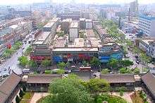
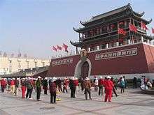
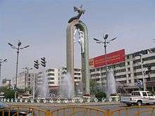
| Capital (and largest city) | Yinchuan |
| Divisions | 5 prefectures, 21 counties, 219 townships |
| Government | |
| • Secretary | Shi Taifeng |
| • Chairwoman | Xian Hui |
| Area[1] | |
| • Total | 66,399.73 km2 (25,637.08 sq mi) |
| Area rank | 27th |
| Highest elevation | 3,556 m (11,667 ft) |
| Population (2010)[2] | |
| • Total | 6,301,350 |
| • Estimate (31 December 2014)[3] | 6,620,000 |
| • Rank | 29th |
| • Density | 89.1/km2 (231/sq mi) |
| • Density rank | 25th |
| Demographics | |
| • Ethnic composition |
Han: 62% Hui: 38% |
| • Languages and dialects | Lanyin Mandarin, Zhongyuan Mandarin |
| ISO 3166 code | CN-NX |
| GDP (2017) |
CNY 345.39 billion USD 51.16 billion (29th) [4] |
| - per capita |
CNY50,917 USD 7,541 (15th) |
| HDI (2014) | 0.727[5] (high) (22nd) |
| Website | http://www.nx.gov.cn/ |
| Ningxia | |||||||||||||||||||||||||||||||||||||||||||||||||
.svg.png) "Níngxià" in Simplified (top) and Traditional (bottom) Chinese characters | |||||||||||||||||||||||||||||||||||||||||||||||||
| Simplified Chinese | 宁夏 | ||||||||||||||||||||||||||||||||||||||||||||||||
|---|---|---|---|---|---|---|---|---|---|---|---|---|---|---|---|---|---|---|---|---|---|---|---|---|---|---|---|---|---|---|---|---|---|---|---|---|---|---|---|---|---|---|---|---|---|---|---|---|---|
| Traditional Chinese | 寧夏 | ||||||||||||||||||||||||||||||||||||||||||||||||
| Xiao'erjing | نٍ ﺷﯿَا | ||||||||||||||||||||||||||||||||||||||||||||||||
| Hanyu Pinyin | Níngxià | ||||||||||||||||||||||||||||||||||||||||||||||||
| Postal | Ningsia | ||||||||||||||||||||||||||||||||||||||||||||||||
| Literal meaning | "Pacified Xia" | ||||||||||||||||||||||||||||||||||||||||||||||||
| |||||||||||||||||||||||||||||||||||||||||||||||||
| Ningxia Hui Autonomous Region | |||||||||||||||||||||||||||||||||||||||||||||||||
| Simplified Chinese | 宁夏回族自治区 | ||||||||||||||||||||||||||||||||||||||||||||||||
| Traditional Chinese | 寧夏回族自治區 | ||||||||||||||||||||||||||||||||||||||||||||||||
| Xiao'erjing | نٍ ﺷﯿَا ﺧُﻮِ ذُﻮْ ذِ جِ ﺛُﻮْ | ||||||||||||||||||||||||||||||||||||||||||||||||
| Hanyu Pinyin | Níngxià Huízú Zìzhìqū | ||||||||||||||||||||||||||||||||||||||||||||||||
| Postal | Ningsia Hui Autonomous Region | ||||||||||||||||||||||||||||||||||||||||||||||||
| |||||||||||||||||||||||||||||||||||||||||||||||||
Ningxia (Chinese: 宁夏; pronounced [nǐŋ.ɕjâ]), officially the Ningxia Hui Autonomous Region (NHAR), is an autonomous region of the People's Republic of China located in the northwest part of the country. Formerly a province, Ningxia was incorporated into Gansu in 1954 but was separated from Gansu in 1958 and was reconstituted as an autonomous region for the Hui people, one of the 56 officially recognised nationalities of China. Twenty percent of China's Hui population lives in Ningxia.[6]
Ningxia is bounded by Shaanxi to the east, Gansu to the south and west, and Inner Mongolia Autonomous Region to the north and has an area of around 66,400 square kilometres (25,600 sq mi).[1] This sparsely settled, mostly desert region lies partially on the Loess Plateau and in the vast plain of the Yellow River, and features the Great Wall of China along its northeastern boundary. Over the years an extensive system of canals has been built. Extensive land reclamation and irrigation projects have made increased cultivation possible.
History
As a frontier zone between nomadic pastoralists and sedentary farmers, Ningxia was a frequent seat of war and incursions by non-Chinese tribes. To pacify the region, the imperial government established military colonies to reclaim land. In addition, horse pasturages were founded under the Imperial Stud to safeguard the supply of army horses, as early as the Western Han Dynasty (206 BCE – 9 CE).[7] Ningxia and its surrounding areas were incorporated into the Qin Dynasty as early as the 3rd century BC. Throughout the Han Dynasty and the Tang Dynasty there were several large cities established in the region. The Liang Province Rebellion at the end of the Han Dynasty affected Ningxia.
By the 11th century the Tangut people had established the Western Xia Dynasty on the outskirts of the then-Song Dynasty. Jews also lived in Ningxia, as evidenced by the fact that, after a major flood destroyed Torah scrolls in Kaifeng, a replacement was sent to the Kaifeng Jews by the Ningbo and Ningxia Jewish communities.[8]
It then came under Mongol domination after Genghis Khan conquered Yinchuan in the early 13th century. Muslims from Central Asia also began moving into Ningxia from the west. The Muslim Dungan Revolt of the 19th century affected Ningxia.
In 1914, Ningxia was merged with the province of Gansu. However, in 1928 it was detached from Gansu and became a separate province. Between 1914 and 1928, the Ma clique ruled the provinces of Qinghai, Ningxia and Gansu; General Ma Hongkui was the military governor of Ningxia and had absolute authority in the province. The Muslim conflict in Gansu, which lasted from 1927 to 1930, spilled over into Ningxia. In 1934, warlord and National Revolutionary Army general Sun Dianying attempted to conquer the province, but was defeated by an alliance led by the Ma clique.[9]
From 1950 to 1958, a Kuomintang Islamic insurgency resulted in fighting throughout Northwest China, including Ningxia. In 1954, the Chinese government merged Ningxia with Gansu, but in 1958 Ningxia formally became an autonomous region of China. In 1969, Ningxia received a part of the Inner Mongolian Autonomous Region, but this area was returned in 1979.
A number of Chinese artifacts dating from the Tang dynasty and Song dynasty, some of which had been owned by Emperor Zhenzong, were excavated and then came into the hands of Ma Hongkui, who refused to publicize the findings. Among the artifacts were a white marble tablet from the Tang dynasty, gold nails, and bands made out of metal. It was not until after Ma died that his wife went to Taiwan in 1971 from America to bring the artifacts to Chiang Kai-shek, who turned them over to the Taipei National Palace Museum.[10]
Geography
Present-day Ningxia is one of the nation’s smallest provincial-level units, and borders the provinces of Shaanxi and Gansu, and the Inner Mongolia Autonomous Region. At 3556 meters above sea level, Aobaoqge (敖包圪/敖包疙瘩) is the highest point in Ningxia.[11]
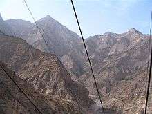
Ningxia is a relatively dry, desert-like region and features a diverse geography of forested mountains and hills, table lands, deserts, flood plains and basins cut through by the Yellow River. The Ningxia ecosystem is one of the least studied regions in the world. Significant irrigation supports the growing of wolfberries, a commonly consumed fruit throughout the region. Ningxia's deserts include the Tengger desert in Shapotou.
The northern section, through which the Yellow River flows, supports the best agricultural land. A railroad, linking Lanzhou with Baotou, crosses the region. A highway has been built across the Yellow River at Yinchuan.
On 16 December 1920, the Haiyuan earthquake, 8.6 magnitude, at 36°36′N 105°19′E / 36.6°N 105.32°E, initiated a series of landslides that killed an estimated 200,000 people. Over 600 large loess landslides created more than 40 new lakes.[12][13]
| Part of a series on Islam in China | ||||||
|---|---|---|---|---|---|---|
 | ||||||
|
||||||
|
| ||||||
In 2006, satellite images indicated that a 700 by 200-meter fenced area within Ningxia—5 km (3.1 mi) southwest of Yinchuan, near the remote village of Huangyangtan—is a near-exact 1:500 scale terrain model reproduction of a 450 by 350-kilometer area of Aksai Chin bordering India, complete with mountains, valleys, lakes and hills. Its purpose is as yet unknown.[14][15]
Grasslands
It was reported that approximately 34 percent (33.85 million mu) of the region’s total surface consisted of grassland.[16] This figure is down from approximately 40 percent in the 1990s. The grasslands are spread over the dry desert-steppe area in the northeast (which forms a part of the Inner Mongolian steppe region), and the hilly pastures located on the semi-arid Loess Plateau in the south.[17] It is ascertained that the grasslands of Ningxia have been degraded to various degrees.[18] However, there is scientific debate as to what extent this degradation is taking place as measured in time and space.[19] Historical research has also found limited evidence of expanding grassland degradation and desertification in Ningxia.[7][20] A major component of land management in Ningxia is a ban on open grazing, which has been in place since 2003.[21] The ecological and socio-economic effects of this Grazing Ban in relation to the grasslands and pastoralists’ livelihood are contested.[22] The ban stipulates that animal husbandry be limited to enclosed pens and no open grazing be permitted in certain time periods set by the Autonomous Region’s People’s Government.
Mineral resources
Ningxia is rich in mineral resources with proven deposits of 34 kinds of minerals, much of which located in grassland areas.[17] In 2011 it was estimated that the potential value per capita of these resources accounted for 163.5 percent of the nation’s average. Ningxia boasts verified coal reserves of over 30 billion tons, with an estimated reserve of more than 202 billion tons, ranking sixth nationwide. Coal deposits are spread over one-third of the total surface of Ningxia, and mined in four major fields in the Helan and Xiangshan mountains, Ningdong and Yuanzhou (or Guyuan). The region’s reserves of oil and natural gas can be found in Yanchi and Lingwu County, and are ideal for large-scale development of oil, natural gas and chemical industries. Ningxia leads China in gypsum deposits, with a proven reserve of more than 4.5 billion tons, of which the rarely found, top-grade gypsum accounts for half of the total deposits. The Hejiakouzi deposit in Tongxin County features a reserve of 20 million tons of gypsum with a total thickness of 100 meters. There is a considerable deposit of quartz sandstone, of which 17 million tons have been ascertained. In addition, there are phosphorus, flint, copper, iron, barite, other minerals and Helan stone – a special clay stone.[23][24]
Climate
The region is 1,200 kilometres (750 mi) from the sea and has a continental climate with average summer temperatures rising to 17 to 24 °C (63 to 75 °F) in July and average winter temperatures dropping to between −7 to −15 °C (19 to 5 °F) in January. Seasonal extreme temperatures can reach 39 °C (102 °F) in summer and −30 °C (−22 °F) in winter. The diurnal temperature variation can reach above 17 °C (31 °F), especially in spring. Annual rainfall averages from 190 to 700 millimetres (7.5 to 27.6 in), with more rain falling in the south of the region.
Governance
The politics of Ningxia is structured in a dual party-government system like all other governing institutions in mainland China.
The Chairman of the Autonomous Region is the highest-ranking official in the People's Government of Ningxia. However, in the Autonomous Region's dual party-government governing system, the Chairman has less power than the Communist Party of China Ningxia Committee Secretary, colloquially termed the "Ningxia CPC Party Chief".
Ningxia has a friendship agreement with Sogn og Fjordane county of Norway.[25]
Administrative divisions
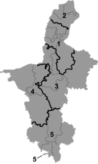
Ningxia is divided into five prefecture-level divisions: all prefecture-level cities:
| Administrative divisions of Ningxia | ||||||||||
|---|---|---|---|---|---|---|---|---|---|---|
 Prefecture-level city district areas County-level cities | ||||||||||
| № | Division code[26] | Division | Area in km2[27] | Population 2010[28] | Seat | Divisions[29] | ||||
| Districts | Counties | CL cities | ||||||||
| 640000 | Ningxia Hui Autonomous Region | 66400.00 | 6,301,350 | Yinchuan city | 9 | 11 | 2 | |||
| 1 | 640100 | Yinchuan city | 8874.61 | 1,993,088 | Jinfeng District | 3 | 2 | 1 | ||
| 2 | 640200 | Shizuishan city | 5208.13 | 725,482 | Dawukou District | 2 | 1 | |||
| 3 | 640300 | Wuzhong city | 21420.14 | 1,273,792 | Litong District | 2 | 2 | 1 | ||
| 5 | 640400 | Guyuan city | 13449.03 | 1,228,156 | Yuanzhou District | 1 | 4 | |||
| 4 | 640500 | Zhongwei city | 17448.09 | 1,080,832 | Shapotou District | 1 | 2 | |||
| Administrative divisions in Chinese and varieties of romanizations | ||||
|---|---|---|---|---|
| English | Chinese | Pinyin | Xiao'erjing | |
| Ningxia Hui Autonomous Region | 宁夏回族自治区 | Níngxià Huízú Zìzhìqū | نٍ ﺷﯿَا ﺧُﻮِ ذُﻮْ ذِ جِ ﺛُﻮْ | |
| Yinchuan city | 银川市 | Yínchuān Shì | ىٍﭼُﻮًا شِ | |
| Shizuishan city | 石嘴山市 | Shízuǐshān Shì | شِذُﻮِشً شِ | |
| Wuzhong city | 吴忠市 | Wúzhōng Shì | ءُﺟْﻮ شِ | |
| Guyuan city | 固原市 | Gùyuán Shì | ﻗُﻮْﻳُﻮًا شِ | |
| Zhongwei city | 中卫市 | Zhōngwèi Shì | ﺟْﻮوِ شِ | |
The five prefecture-level divisions of Ningxia are subdivided into 22 county-level divisions (9 districts, 2 county-level cities, and 11 counties).
Urban areas
| Population by urban areas of prefecture & county cities | |||||
|---|---|---|---|---|---|
| # | City | Urban area[30] | District area[30] | City proper[30] | Census date |
| 1 | Yinchuan | 1,159,457 | 1,290,170 | 1,993,088 | 2010-11-01 |
| 2 | Shizuishan | 403,901 | 472,472 | 725,482 | 2010-11-01 |
| 3 | Wuzhong | 232,134 | 544,362 | 1,273,792 | 2010-11-01 |
| 4 | Zhongwei | 160,279 | 378,606 | 1,080,832 | 2010-11-01 |
| 5 | Guyuan | 130,155 | 411,854 | 1,228,156 | 2010-11-01 |
| 6 | Lingwu | 125,976 | 261,677 | see Yinchuan | 2010-11-01 |
| 7 | Qingtongxia | 99,367 | 264,717 | see Wuzhong | 2010-11-01 |
Economy
Rural Ningxia was for long an officially designated poverty area, and is still located on the lower rungs of the developmental ladder.[17] It is the province with the third smallest GDP (Tibet being the last) in China, even though its neighbors, Inner Mongolia and Shaanxi, are among the strongest emerging provincial economies in the country. Its nominal GDP in 2011 was just 200.0 billion yuan (US$32.7 billion) and a per capita GDP of 21,470 yuan (US$3,143). It contributes 0.44% of the national economy.
Unlike several other underdeveloped provinces, labor costs in Ningxia are among the highest in China (ranking in the top third percentile), making it unattractive as a manufacturing center. Furthermore, Ningxia has yet to become a hub for consumption due to its low population.
Agriculture
Similar to other areas, Ningxia has seen a gradual decline of its peasant population due to rural–urban migration. In spite of this, the great majority (62.8 percent) was still agricultural at the time of the survey.[31] Animal husbandry is important for the regional economy. In the main pastoral county, Yanchi, it is even the leading industry when specified for the primary sector. The dominant grazing animals are sheep and goat.[32] In the (semi-)pastoral regions, herders engage in a mixed sedentary farming operation of dryland agriculture and extensive animal husbandry, while full nomadic pastoralism is no longer practiced.[17]
Ningxia is the principal region of China where wolfberries are grown. Other specialties of Ningxia are licorice, products made from Helan stone, fiddlehead and products made from sheepskin.
Ningxia wines are a promising area of development. The Chinese authorities have given approval to the development of the eastern base of the Helan Mountains as an area suitable for wine production. Several large Chinese wine companies including Changyu and Dynasty Wine have begun development in the western region of the province. Together they now own 20,000 acres of land for wine plantations and Dynasty has ploughed 100 million yuan into Ningxia. In addition, the major oil company China Petroleum and Chemical Corporation has founded a grape plantation near the Helan Mountains. The household appliance company Midea has also begun participating in Ningxia's wine industry.[33] Vineyards have been set up in the region.[34]
Industries and economic zones
Yinchuan Economic and Technological Development Zone[35] was established in 1992. Spanning 32 km2 (12 sq mi), it has an annual economic output Rmb23.7 billion (25.1% up) (US$3.5 billion). Major investors are mainly local enterprises such as Kocel Steel Foundry, FAG Railway Bearing (Ningxia), Ningxia Little Giant Machine Tools, etc. Major industries include machinery and equipment manufacturing, new materials, fine chemicals and the animation industry.
Desheng Industrial Park (in Helan County) is a base for about 400 enterprises. The industrial park has industrial chains from Muslim food and commodities to trade and logistics, new materials and bio-pharmaceuticals that has 80 billion yuan in fixed assets. Desheng is looking to be the most promising industrial park in the city. It achieved a total output value of 4.85 billion in 2008, up 40 percent year-on-year. The local government plans to cut taxes and other fees to reduce the burden on local enterprises. The industrial output value reached 2.68 billion yuan in 2008, an increase of 48 percent from a year earlier.
Transport
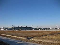
Airports
- Yinchuan Hedong Airport
- Zhongwei Shapotou Airport
- Guyuan Liupanshan Airport
- Wuhai Airport (serves the northern area)
Highways
Bridge
- Taole Yellow River Expressway Bridge (陶乐黄河大桥)
Rail
- Baotou-Lanzhou Railway (包兰铁路)
- Baozhong Railway (宝中铁路)
Education
Demographics
| Historical population | ||
|---|---|---|
| Year | Pop. | ±% |
| 1912[36] | 303,000 | — |
| 1928[37] | 1,450,000 | +378.5% |
| 1936-37[38] | 978,000 | −32.6% |
| 1947[39] | 759,000 | −22.4% |
| 1982[40] | 3,895,578 | +413.3% |
| 1990[41] | 4,655,451 | +19.5% |
| 2000[42] | 5,486,393 | +17.8% |
| 2010[43] | 6,176,900 | +12.6% |
| Ningxia Province/AR was part of Gansu 1914-1929 and 1954-1958 In 1947 parts of Ningxia Province/AR were incorporated into Inner Mongolia AR. | ||
Religion
Religion in Ningxia (around 2010)
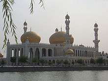
The major religions in Ningxia are Islam among the Hui Chinese, while many of the Han Chinese practice Chinese folk religions, Taoism, Confucianism and Chinese Buddhism. According to a demographic analysis of the year 2010, Muslims form 34% of the province's population.[44] Christianity is the religion of 1.17% of the province's population according to the Chinese General Social Survey of 2004.[45]
Hospitals
- People's Hospital of Ningxia
- Hospital of Traditional Chinese Medicine of Ningxia
- Ningxia Medical College Affiliated Hospital
- Yinchuan Hospital of Traditional Chinese Medicine
- Yinchuan People's Hospital
- Yinchuan Stomatological Hospital
- Yinchuan Women and Children's Healthcare Center
- Women and Children's Healthcare Center of Ningixa
- Yinchuan No.1 People's Hospital
- Yinchuan No.2 People's Hospital
- Yinchuan No.3 People's Hospital
- Shizuishan No.2 People's Hospital
- Guyuan Hospital of Ningxia
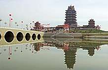
Tourism
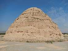
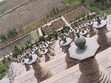
One of Ningxia's main tourist spots is the internationally renowned Xixia Tombs site located 30 km (19 mi) west of Yinchuan. The remnants of nine Western Xia emperors' tombs and two hundred other tombs lie within a 50 km2 (19 sq mi) area. Other famous sites in Ningxia include the Helan Mountains, the mysterious 108 stupas, the twin pagodas of Baisikou and the desert research outpost at Shapatou. A less visited tourist spot in Ningxia is the Mount Sumeru Grottoes (须弥山), which is among the ten most famous grottoes in China.[46]
Museums
- Ningxia Museum, opened in 1988
- Ningxia Transportation Museum, opened in August 2008
See also
References
- 1 2 "Administrative Divisions (2013)". Ningxia Statistical Yearbook 2014. Statistical Bureau of Ningxia. Retrieved 19 December 2015.
- ↑ "Communiqué of the National Bureau of Statistics of People's Republic of China on Major Figures of the 2010 Population Census [1] (No. 2)". National Bureau of Statistics of China. 29 April 2011. Archived from the original on 27 July 2013. Retrieved 4 August 2013.
- ↑ "National Data". National Bureau of Statistics of China. Retrieved 19 December 2015.
- ↑ 《宁夏回族自治区2017年国民经济和社会发展统计公报》 (web) (in Chinese). Statistical Bureau of Ningxia. 2017.
- ↑ 《2013中国人类发展报告》 (PDF) (in Chinese). United Nations Development Programme China. 2013. Retrieved 2014-05-14.
- ↑ "By choosing assimilation, China's Hui have become one of the world's most successful Muslim minorities". The Economist. 8 October 2016. Retrieved 8 October 2016.
- 1 2 Ho, Peter (2000). "The Myth of Desertification at China's Northwestern Frontier: The Case of Ningxia Province, 1929-1958". Modern China. 26 (3): 348–395. doi:10.1177/009770040002600304. ISSN 0097-7004.
- ↑ Xu Xin, The Jews of Kaifeng, Ktav Publishing House, c. 2003.
- ↑ Lin (2011), pp. 37–39.
- ↑ China Archaeology and Art Digest, Volume 3, Issue 4. Art Text (HK) Ltd. 2000. p. 354. Retrieved 2010-11-28.
- ↑ 登敖包疙瘩 赏绝顶美景 .凤凰资讯.2014-9-2[引用日期2016-01-31] http://news.ifeng.com/a/20140902/41825100_0.shtml
- ↑ Close, U., and McCormick (1922) "Where the mountains walked" National Geographic Magazine 41(5): pp.445–464.
- ↑ Feng, X. and Guo, A. (1985) "Earthquake landslides in China" In Proceedings, IVth International Conference and Field Workshop on Landslides pp. 339–346, Japan Landslide Society, Tokyo, OCLC 70324350.
- ↑ Haines, Lester (19 July 2006)."Chinese black helicopters circle Google Earth". The Register
- ↑ Cassidy, Katherine (13 September 2006). "Armchair Sleuths Uncover Strange Military Sites in China". McClatchy Newspapers / Real Cities Network.
- ↑ Ningxia Bureau of Statistics, 2013, 1.2
- 1 2 3 4 Ho, Peter (2016) "Empty institutions, non-credibility and pastoralism: China's grazing ban, mining and ethnicity" Journal of Peasant Studies 43(6): pp.1145-1176
- ↑ Ho, Peter; Azadi, Hossein (2010). "Rangeland degradation in North China: Perceptions of pastoralists". Environmental Research. 110 (3): 302–307. doi:10.1016/j.envres.2009.12.007.
- ↑ Ho, P. (2001). "Rangeland Degradation in North China Revisited? A Preliminary Statistical Analysis to Validate Non-Equilibrium Range Ecology". The Journal of Development Studies. 37 (3): 99–133. doi:10.1080/00220380412331321991. ISSN 0022-0388.
- ↑ Ho, Peter (2003). "Mao's War against Nature? The Environmental Impact of the Grain-First Campaign in China". The China Journal. 50: 37–59. doi:10.2307/3182245. ISSN 1324-9347.
- ↑ Zhou, Z. 2013. A view of Ningxia ten years since the grazing ban [Jìn mù yī nián kàn Níngxià]. People’s Daily, June 29. p. 10.
- ↑ Ho, Peter (2016). "Empty institutions, non-credibility and pastoralism: China's grazing ban, mining and ethnicity". The Journal of Peasant Studies. 43 (6): 1145–1176. doi:10.1080/03066150.2016.1239617. ISSN 0306-6150.
- ↑ Hsieh, C.M. 2016. Ningxia. Encyclopædia Britannica. http://www.britannica.com/place/Ningxia.
- ↑ Zhongguo Baike Wang, ed. 2011. Ningxia kuangchan ziyuan gaikuang ji fenbu [Overview and dis- tribution of mineral resources in Ningxia]. Zhongguo Baike Wang, March 16. http://www.chinabaike.com/z/keji/ck/543057.html
- ↑ "Ningxia og Sogn og Fjordane eit steg vidare på samarbeidsvegen". Sfj.no. Retrieved 2015-05-07.
- ↑ "中华人民共和国县以上行政区划代码" (in Chinese). Ministry of Civil Affairs.
- ↑ Shenzhen Statistical Bureau (深圳市统计局). 《深圳统计年鉴2014》 (in Chinese). China Statistics Print (中国统计出版社). Retrieved 2015-05-29.
- ↑ shi, Guo wu yuan ren kou pu cha ban gong; council, Guo jia tong ji ju ren kou he jiu ye tong ji si bian = Tabulation on the 2010 population census of the people's republic of China by township / compiled by Population census office under the state; population, Department of; statistics, employment statistics national bureau of (2012). Zhongguo 2010 nian ren kou pu cha fen xiang, zhen, jie dao zi liao (Di 1 ban. ed.). Beijing Shi: Zhongguo tong ji chu ban she. ISBN 978-7-5037-6660-2.
- ↑ Ministry of Civil Affairs (August 2014). 《中国民政统计年鉴2014》 (in Chinese). China Statistics Print (中国统计出版社). ISBN 978-7-5037-7130-9.
- 1 2 3 国务院人口普查办公室、国家统计局人口和社会科技统计司编 (2012). 中国2010年人口普查分县资料. Beijing: 中国统计出版社 [China Statistics Print]. ISBN 978-7-5037-6659-6.
- ↑ Ningxia Bureau of Statistics 2013, 4.2
- ↑ Ningxia Bureau of Statistics 2013, 11.20
- ↑ "Grape expansion: Chinese wine companies move west" Archived 2015-07-31 at the Wayback Machine., Want China Times, 15 December 2011. Retrieved 17 December 2011.
- ↑ Phillips, Tom (14 June 2016). "China's Bordeaux: winemakers in 'gold rush' to turn desert into vineyards". The Guardian. Helan county, Ningxia province.
- ↑ "欢迎访问银川经济技术开发区网站". Ycda.gov.cn. 2015-04-24. Retrieved 2015-05-07.
- ↑ "1912年中国人口". Retrieved 6 March 2014.
- ↑ "1928年中国人口". Retrieved 6 March 2014.
- ↑ "1936-37年中国人口". Retrieved 6 March 2014.
- ↑ "1947年全国人口". Retrieved 6 March 2014.
- ↑ "中华人民共和国国家统计局关于一九八二年人口普查主要数字的公报". National Bureau of Statistics of China. Archived from the original on 2012-05-10.
- ↑ "中华人民共和国国家统计局关于一九九〇年人口普查主要数据的公报". National Bureau of Statistics of China. Archived from the original on 2012-06-19.
- ↑ "现将2000年第五次全国人口普查快速汇总的人口地区分布数据公布如下". National Bureau of Statistics of China. Archived from the original on 2012-08-29.
- ↑ "Communiqué of the National Bureau of Statistics of People's Republic of China on Major Figures of the 2010 Population Census". National Bureau of Statistics of China. Archived from the original on 2013-07-27.
- 1 2 Min Junqing. The Present Situation and Characteristics of Contemporary Islam in China. JISMOR, 8. 2010 Islam by province, page 29. Data from: Yang Zongde, Study on Current Muslim Population in China, Jinan Muslim, 2, 2010.
- 1 2 China General Social Survey 2004. Report by: Xiuhua Wang (2015, p. 15) Archived 2015-09-25 at the Wayback Machine.
- ↑ "Guyuan Travel Guide: Map, Location, Climate, Attractions". Travelchinaguide.com. Retrieved 2015-01-29.
- Lin, Hsiao-ting (2011). Modern China's Ethnic Frontiers: A Journey to the West. Abingdon-on-Thames: Routledge.
External links
- Ningxia Provincial Government
- Ningxia Agricultural Information Network
- Ningxia Investment Promotion Bureau
- Britnannica Ningxia
- Economic profile for Ningxia at HKTDC
- Profile of Ningxia at china.org.cn
- Ningxia 2004 - The Year in Review
- Ningxia 2005 - The Year in Review
- Ningxia Profile - UNESCAP
- Ningxia Center for the Environment and Poverty Alleviation
- Ningxia Profile - China Economic Information Network
- Ningxia (autonomous region, China) -- Britannica Online Encyclopedia
Places adjacent to Ningxia | ||||||||||
|---|---|---|---|---|---|---|---|---|---|---|
| ||||||||||
| Provinces |  | |
|---|---|---|
| Autonomous regions | ||
| Municipalities | ||
| Special administrative regions | ||
| Other | ||
Note: Taiwan is claimed by the People's Republic of China but administered by the | ||
| Authority control |
|---|