Mangshi
| Mangshi 芒市 | |
|---|---|
| County-level city | |
| Other transcription(s) | |
| • Pinyin | Mángshì |
| • Tai Nuea | ᥝᥥᥒᥰ ᥛᥫᥒᥰ ᥑᥩᥢᥴ |
| • Jingpho | Mangshi Myu |
| • Burmese | မန်စီ |
| • Thai | เมืองข้อน |
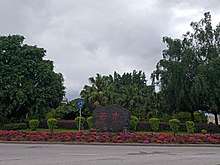
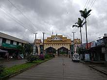
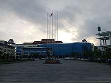
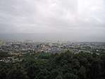 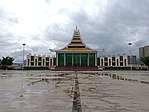 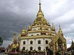  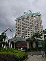  From top, left to right: Skyline of Mangshi, Mangshi Square with China-Myanmar Friendship Memorial Hall, Menghuan Pagoda, Menghuan Road upper, Mangshi Hotel, Mangshi fortune center plaza | |
| Etymology: Evolved form the ethnic name 茫施 (Mangshi) | |
| Nickname(s): city of dawn | |
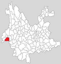 Territory of Mangshi (red) in Yunnan Province | |
 Mangshi Location in Yunnan | |
| Coordinates: 24°27′N 98°36′E / 24.450°N 98.600°ECoordinates: 24°27′N 98°36′E / 24.450°N 98.600°E | |
| Country | People's Republic of China |
| Province | Yunnan |
| Prefecture | Dehong Dai and Jingpo Autonomous Prefecture |
| Founded | 1996 |
| Seat | Menghuan Subdistrict |
| Government | |
| • Mayor | Mao Xiao (毛晓) (CPC) |
| • Secretary of CPC City Committee | Zhao Dongmei (赵冬梅) |
| Area[1]:536 | |
| • Total | 2,900.91 km2 (1,120.05 sq mi) |
| Elevation | 933 m (3,061 ft) |
| Population (2016)[2] | |
| • Total | 410,426 |
| • Density | 140/km2 (370/sq mi) |
| Time zone | UTC+8 |
| Postal code | 678400 |
| Phone code | (0)692 |
| Website |
www |
Mangshi City (Chinese: 芒市; Tai Nuea: ᥝᥥᥒᥰ ᥛᥫᥒᥰ ᥑᥩᥢᥴ; Jingpho: Mangshi Myu), formerly named Luxi City (潞西市),[3] in some literatures is written as Mangshih,[4] is a county-level city of Dehong Dai and Jingpo Autonomous Prefecture, in the west of Yunnan province, People's Republic of China. It is the prefectural seat. Mangshi has an area of 2,900.91 km2 (1,120.05 sq mi), with an urban area of 18.66 km2 (7.20 sq mi).[2] Han Chinese, Dai people Tai Nuea branch and Jingpo people Zaiwa branch are the major ethnic group. In the history, Mangshi was divided into 3 tusi territory. Luxi County was founded in 1949, and finally upgraded to a county-level city in 1996.
Etymology
The city name "Mangshi" first appeared in 1443, when the tusi of Mangshi Yuyi Zhangguan Si (芒市御夷长官司) established. In the history, there was an ethnic named Mangshi (茫施) lived in this area. The name of "芒市" was evolved from "茫施" (the pinyin are same). Luxi (潞西) is the former name of Mangshi, which means "west of Lu [Salween] River".[5]:460
In Tai Nuea language, the city name is Mengkhuan (ᥛᥫᥒᥰ ᥑᥩᥢᥴ), written in Chinese is "勐焕", which means "city of dawn".[5]:460
In 2008, 4,751 people participated in a public opinion survey in favour of restoring the historical name (Mangshi), with 96.96% supporting a name change to Mangshi.[3] In 2010, the name of the county-level city was formally changed. "Mangshi" is the proper noun of the city, the character "市" (shì) also is the administrative division name.[6] The full name in Chinese language is "芒市" (Mangshi), but the official English translation in the Yearbook of Dehong is "Mangshi City".[7]
History

Mangshi Lu (茫施路) is the first administrative division of Mangshi which established by Yuan dynasty in 1276, Mangshi Lu belonged to Jinchi Xuanfu Si (金齿等处宣抚司), Yunnan Province. In 1277, the war of first Mongol invasion of Burma was spread in this area. Ming dynasty repeal Mangshi Lu and set Mangshi Fu (茫施府) in 1382. Because Mangshi chief Dao Fangge (刀放革) helped the Ming dynasty army in the Luchuan–Pingmian campaigns, Ming dynasty canonized him to be the Mangshi Tusi, and set the agency Mangshi Yuyi Zhangguan Si (芒市御夷长官司) in 1443. In 1584, Ming dynasty set another tusi, Zhefang Vice Xuanfu Si (遮放副宣抚司) in Zhefang area, which separated from Longchuan Xufanfu Si (陇川宣抚司). In 1640, Mangshi Yuyi Zhangguan Si upgraded to Mangshi Anfu Si (芒市安抚司). In 1899, Qing dynasty set the 3rd tusi of Mengban Tuqianzong (勐板土千总) in modern Mangshi Area.[9]:9,20–21
In Republic of China period, the central government set two "suppression committees" (彈壓委員) in Mangshi area named "Mangban" (芒板) and "Zhemao" (遮卯) in 1913. Mangban Suppress Committee dominated Mangshi Anfu Si and Mengban Tuqianzong territory, and Zhemao Suppression Committee dominated Zhefang Vice Xuanfu Si and Mengmao Anfu Si (勐卯安撫司, in Ruili) territory. The two suppression committees compounded to an administrative committee (行政委員) in 1915 and set a district named Mangzheban District (芒遮板行政區), at same time Mengmao Anfu Si separated away from the district. It formed the territory of modern Mangshi. As a transition to formally establishing a county, Yunnan government set a "Administrative Bureau" (設治局, similar to a governing council) in Mangshi area named Mangzheban Administrative Bureau (芒遮板設治局) replaced Mangzheban District in 1929. The Administrative Bureau is a quasi-county level administrative division, Mengga is the seat of Mangzheban Administrative Bureau. Mangzheban Administrative Bureau was changed the name to Luxi Administrative Bureau (潞西設治局) in 1934. Imperial Japanese Army occupied Luxi at 4 May 1942 and retreated at 11 December 1944 when Counterattack Battle of Western Yunnan started. In 1949, Luxi Administrative Bureau was finally upgraded to Luxi County (潞西县), with the seat of county government at the town of Mangshi, and the first county magistrate was the proxy tusi Fang Kesheng (方克胜). The tusi and administrative governments still coexisted.[9]:10–11,21–22
Luxi County government announced support Yunnan revolt, People's Liberation Army stationed in Luxi in April 1950. Three Tusi were perished during the land reform movement in 1955.[8]:160 Luxi County upgraded to Luxi City (county-level city) in 1996, and changed the name to Mangshi City in 2010.[10]:2547
Geography
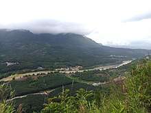
Mangshi has an area of 2,900.91 km2 (1,120.05 sq mi). There are two main basins in Mangshi named Mangshi Ba (芒市坝) and Zhefang Ba (遮放坝). The city of Mangshi is situated at the east of Mangshi Ba. Mountain is the mostly landform of Mangshi, approximately 84.48% of the territory. Qingkou Mount (箐口山) is the city's highest point, with an altitude of 2,889.1 metres. Manxin River's (曼辛河) estuary (flow to Salween River) is the lowest point, with an altitude of 528 metres in Zhongshan Township.[9]:52–53 The mountains are the branches of the west Gaoligong Mountains.[11]:40
Mangshi River is the "mother river" of Mangshi,[12] and has a drainage basin of 1,881 km2 (726 sq mi),[13]:90–91 about 61.3% of area of Mangshi. Longchuan River (龙川江) is the border river between Mangshi and Lianghe County, Longchuan County on the north and west. Salween River on the southeast tip of Mangshi marks the international border between Mangshi and Myanmar's Shan State.[9]:59[5]:185
| Month | Jan | Feb | Mar | Apr | May | Jun | Jul | Aug | Sep | Oct | Nov | Dec | Year |
|---|---|---|---|---|---|---|---|---|---|---|---|---|---|
| Record high °C (°F) | 27.0 (80.6) |
31.0 (87.8) |
33.4 (92.1) |
35.2 (95.4) |
35.6 (96.1) |
34.9 (94.8) |
34.4 (93.9) |
35.3 (95.5) |
35.0 (95) |
33.4 (92.1) |
29.7 (85.5) |
27.4 (81.3) |
35.6 (96.1) |
| Average high °C (°F) | 22.1 (71.8) |
23.9 (75) |
27.3 (81.1) |
29.5 (85.1) |
29.5 (85.1) |
28.7 (83.7) |
28.0 (82.4) |
29.0 (84.2) |
29.1 (84.4) |
27.8 (82) |
25.0 (77) |
22.4 (72.3) |
26.9 (80.3) |
| Daily mean °C (°F) | 12.6 (54.7) |
14.5 (58.1) |
17.9 (64.2) |
21.1 (70) |
23.3 (73.9) |
24.2 (75.6) |
23.9 (75) |
24.2 (75.6) |
23.5 (74.3) |
21.5 (70.7) |
17.3 (63.1) |
13.7 (56.7) |
19.8 (67.7) |
| Average low °C (°F) | 6.1 (43) |
7.7 (45.9) |
10.7 (51.3) |
14.7 (58.5) |
18.7 (65.7) |
21.4 (70.5) |
21.5 (70.7) |
21.5 (70.7) |
20.4 (68.7) |
17.8 (64) |
12.5 (54.5) |
8.1 (46.6) |
15.1 (59.2) |
| Record low °C (°F) | −0.2 (31.6) |
1.5 (34.7) |
3.6 (38.5) |
7.5 (45.5) |
13.2 (55.8) |
16.8 (62.2) |
15.9 (60.6) |
17.6 (63.7) |
14.5 (58.1) |
9.3 (48.7) |
5.5 (41.9) |
1.0 (33.8) |
−0.2 (31.6) |
| Average precipitation mm (inches) | 13.7 (0.539) |
26.6 (1.047) |
26.9 (1.059) |
65.4 (2.575) |
154.3 (6.075) |
287.5 (11.319) |
360.1 (14.177) |
317.7 (12.508) |
187.0 (7.362) |
137.9 (5.429) |
49.8 (1.961) |
11.8 (0.465) |
1,638.7 (64.516) |
| Average relative humidity (%) | 78 | 72 | 66 | 67 | 75 | 84 | 87 | 86 | 84 | 83 | 82 | 81 | 79 |
| Source: China Meteorological Data Service Center | |||||||||||||
Administrative divisions
Mangshi currently comprises 12 administrative township-level subdivisions including 1 subdistrict, 5 towns and 6 townships.
| Name | Name in Chinese |
Code[14] | Founded [5]:459–495 |
Area(km2) [10]:2552–2572 |
Population 2010 Census[15] |
Density |
|---|---|---|---|---|---|---|
| Menghuan Subdistrict | 勐焕街道 | 533103001 | 2008 | 23.15 | 99,970 | 4318.36 |
| Mangshi Town | 芒市镇 | 533103101 | 1936 | 349.5 | 46,353 | 132.63 |
| Zhefang Town | 遮放镇 | 533103102 | 1936 | 422 | 51,477 | 121.98 |
| Mengga Town | 勐戛镇 | 533103103 | 1936 | 389 | 24,344 | 62.58 |
| Manghai Town | 芒海镇 | 533103104 | 1988 | 105 | 5,641 | 53.72 |
| Fengping Town | 风平镇 | 533103105 | 1998 | 381 | 69,586 | 182.64 |
| Xuangang Township | 轩岗乡 | 533103201 | 1936 | 163.7 | 21,501 | 131.34 |
| Jiangdong Township | 江东乡 | 533103202 | 1988 | 220.8 | 25,240 | 114.31 |
| Xishan Township | 西山乡 | 533103203 | 1988 | 257 | 12,296 | 47.84 |
| Zhongshan Township | 中山乡 | 533103204 | 1988 | 278 | 10,170 | 36.58 |
| Santaishan Palaung Township | 三台山德昂族乡 | 533103205 | 1988 | 158 | 7,068 | 44.73 |
| Wuchalu Township | 五岔路乡 | 533103206 | 1988 | 202 | 16,245 | 80.42 |
Economy


As of 2016, Mangshi nominal GDP was CN¥ 9.628 billion, about 0.65% of the province's GDP and ranked 44th among county-level administrative units in Yunnan; its nominal GDP per capita was CN¥ 23,307 and ranked the 66th in the province, lower than Yunnan average value (CN¥ 30,949).[1]:522,524
In 1958, Yunnan government regulated the border trade in border area, Mangshi was out of the area.[16]:211 In 1980, province government opened Manghai (芒海), Mangbing (芒丙) and Xiaogai (小街) to be the border trade market.[16]:201 After Hu Yaobang, the General Secretary of the Communist Party of China inspected Dehong prefecture in 1985, Mangshi revoked all the border checkpoint, and made the whole territory to be the border trade zone.[17]:645 The border trade and other tertiary sector was prosperity in 1990s. The proportion of thrice industrial in 1978 was 65.6 : 16.3 : 18.1,[17]:647 and in 2016 was changed to 23.2 : 20.5 : 56.3.[1]:524
Asian rice, sugarcane, tea, coffee, macadamia nut and fruits (banana, pineapple, mango, jackfruit etc.) are the mostly agricultural products of Mangshi, especially coffee. Mangshi has 19,056 ha paddy field, 9,165 ha sugarcane field, 7,504 ha macadamia forest, 5,870 ha coffee field and 5,469 ha fruits field in 2018.[18] Asian Coffee Association was established at Mangshi in 2017,[19] 13 countries are the members of the association.[20] Hogood Coffee is the largest domestic instant coffee producer in China,[21] and it is the 10th largest civilian-run enterprise of Yunnan.[22]
Population
| Historical population | ||
|---|---|---|
| Year | Pop. | ±% p.a. |
| 1919 | 49,105 | — |
| 1932 | 39,618 | −1.64% |
| 1947 | 50,832 | +1.68% |
| 1953 | 109,718 | +13.68% |
| 1964 | 152,763 | +3.05% |
| 1982 | 244,411 | +2.65% |
| 1990 | 292,183 | +2.26% |
| 2000 | 337,406 | +1.45% |
| 2010 | 389,891 | +1.46% |
| Source: Annals of Luxi County etc.[9]:40–41[23][24]:6 | ||
In 2016, Mangshi had a total population of 415.7 thousand within the whole territory,[1]:533 of which 171.2 thousand resided in city urban, the subdistrict of Menghuan.[25]
According to the 2010 census, Mangshi has 204,083 Han Chinese people, nearly 52.34% of total population. Other mainly ethnics are Dai and Jingpo, which has a population with 132,421 and 29,208.[24]:101–121 Mangshi has the most Palaung people in China with the population of 9,986,[24]:101–121 they mainly living in Santaishan Palaung Township.[9]:39
In the history, Dai people were lived in Mangshi basin area,[9]:420 and Jingpo people immigrated to Mangshi mountains from Tibetan Plateau in 16 century.[9]:425 Because the war of Ming conquest of Yunnan and several times Sino-Burmese wars, China center government stationed many of Han Chinese army in Mangshi, Han Chinese became the most ethnic group of this area.[5]:227
Culture
Dai people in Mangshi speak Tai Nuea language,[9]:420 Jingpo people speak Zaiwa language and Jingpho language, Zaiwa is the most ethnic branch of Jingpo people in Mangshi.[9]:426
Almost all the Dai and Palaung people believe theravada, many of villages have their own temple.[9]:422 The temple in Mangshi is called "Zhuangfang" (奘房) or "Burmese temple" (缅寺). It is the place for religion activities and teenager's education center of the village, also is the entertainment venue for villagers.[26]:154,156 Expenditure of the temple and the monk life costs are afford by the villagers. A normal Dai farmer should pay one-fifth of his annual income for religion in 1988.[9]:422 Jingpo folk religion worships various gods as well as the spirits of their ancestors.[9]:451
Songkran and Manau are the most grand festival of Dai and Jingpo, they are statutory holidays of Dehong autonomous prefecture.[27]
Transport
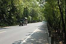
Mangshi Tusi Fang Keming (方克明) and Zhefang Tusi Duo Jianxun (多建勋) decided to built a road to link Mangshi and Wanding in 1926, they invited an Indian engineer to designed the route. This road was built up in 1931, and became a part of Burma Road in 1937.[9]:152 In modern China National Highways network, this road is part of G320 Highway.[28]:42 Longling-Ruili Expressway opened on 31 Dec. 2015, it is the first expressway of Mangshi which is part of G56 Hangzhou–Ruili Expressway, also is part of AH14.[29] The construction of Mangshi-Lianghe Expressway has already begun, it is a province-level expressway.[30] Another province-level expressway Ruili-Menglian Expressway is under planning.[31]
Dali–Ruili railway is under construction, there are two rail stations in Mangshi: Mangshi and Mangshi West.[32]
Dehong Mangshi Airport is the only airport of Dehong Prefecture, which has 1,652,533 passengers and 13,982 aircraft movements in 2017.[33]
Social
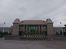
Dehong Sports Center is located on the west of Mangshi, with a 21,000-capacity stadium, a 3,200-capacity basketball gym, a 2,150-capacity aquatics center, a 6-courts tennis gym and other outdoor sports fields. The sports center was built up in 2008, it has a building area of 36,813.49㎡. Dehong Sports Center is the important cultural and sports activities place of Dehong.[34]
Dehong People's Hospital is a Tertiary B-level hospital which built in 1954 located in southeast of Mangshi.[17]:551 It has 1,200 beds and the service area covered up Dehong, Longling, Tengchong and part of Myanmar.[35]
Dehong Normal College (德宏师范高等专科学校) is the mainly higher education college of Dehong which established in 2006.[17]:491 It is a technical college but under the working for upgrade to a undergraduate education university.[36] Many of Myanmar students are studying abroad in Dehong Normal College.[37]
Because there are more than one ethnic living in Dehong territory, they speak in different language. Media of Dehong is also in several languages. Dehong TV Station was established in 1991, they set Chinese, Tai Nuea, Jingpho and Zaiwa television shows. Dehong TV Station is the only TV station which using 4 languages in China.[17]:522 Dehong Unity Newspaper (德宏团结报) is the official newspaper of Dehong Prefecture Committee of the Communist Party of China. The newspaper using 5 languages: Chinese, Tai Nuea, Jingpho, Zaiwa and Lisu. It is the only newspaper which using 5 languages in China.[17]:518 Pauk-Phaw, the first Burmese newspaper of China, had founded at Mangshi in 2015 and published by Dehong Unity Newspaper office, Pauk-Phaw could served 50,000 Burmese who abroad in China.[38]
Tourism
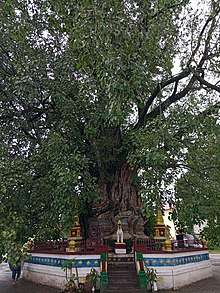
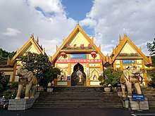
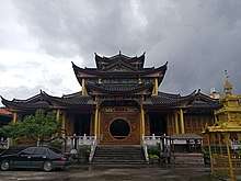
There were 3.3 million tourists visited Mangshi in 2015, and took CN¥ 5.09 billion tourism income for the city.[2] Puti Temple,[39] Wuyun Temple and Foguang Temple are well known Buddhist temples in Mangshi.[26]:155 Tiecheng Pagoda, Fengping Pagoda and Menghuan Pagoda are well known Buddhist pagodas.[9]:462 Tiecheng Pagoda also named "Shubao Pagoda" (树包塔, means pagoda wrapped by tree). The pagoda was built in Qianlong period, Qing dynasty, and a seed fell in the crack of the pagoda about 200 years ago. Nowadays the pagoda has been wrapped by the bodhi tree.[40]:262[26]:53 Mengbanaxi Exotics Garden is the only AAAA state-level scenic spot of Mangshi, it is a gathering of valuables ancient trees and tree fossils.[41]
Friendly cities
Mangshi currently maintains friendly city agreements with the following foreign cities.


See also
References
- 1 2 3 4 Li Cheng (李赪) (2012). 《云南统计年鉴2017》 [Statistical Yearbook of Yunnan 2017] (in Chinese). Beijing: China Statistics Press. ISBN 978-7-5037-8267-1.
- 1 2 3 芒市市情概况 [Overview of Mangshi]. www.dhms.gov.cn (in Chinese). Mangshi government. 2016-06-29. Retrieved 2018-08-03.
- 1 2 国务院正式批复同意潞西更名为芒市 (in Chinese). Yunnan Xinhua. 2010-07-23. Retrieved 2010-12-04.
- ↑ J. J. G. Syatauw (1961). Some newly established Asian states and the development of international law. p. 120.
- 1 2 3 4 5 德宏傣族景颇族自治州志编纂委员会 (1994). 《德宏州志·综合卷》 [Annals of Dehong Prefecture · Integrated Volume] (in Chinese). Mangshi: Dehong Nationalities Publishing House. ISBN 7-8052-5248-3.
- ↑ Wei Yinxia (魏银霞) (2010-09-28). 云南省德宏州州府潞西市正式更名为“芒市” [Luxi ,the capital of Dehong Prefecture in Yunnan, official name change to Mangshi]. 孔雀之乡网 (in Chinese). Mangshi. Retrieved 2018-07-24.
- ↑ Executive chief editor: Tian Qiyun (田启云); 德宏傣族景颇族自治州志编纂委员会 (2017). 《德宏年鉴2017》 [Yearbook of Dehong 2017] (in Chinese). Mangshi: Dehong Nationalities Publishing House. p. English Contents page1. ISBN 978-7-5558-0726-1.
- 1 2 德宏州政协文史和学习委 (1997). 《德宏州文史资料选辑 第十辑(德宏土司专辑)》 [Compilation of History Reference of Dehong Prefecture - 10th volume (Dehong Tusi volume)] (in Chinese). Mangshi: Dehong Nationalities Publishing House. ISBN 7-80525-340-4.
- 1 2 3 4 5 6 7 8 9 10 11 12 13 14 15 16 云南省潞西县志编纂委员会 (1993). 《潞西县志》 [Annals of Luxi County] (in Chinese). Kunming: Yunnan Education Publishing House. ISBN 7-5415-0685-0.
- 1 2 Ministry of Civil Affairs (2016). 《中华人民共和国政区大典 云南卷》 [People's Republic of China Administrative Divisions Encyclopedia Yunnan Volume] (in Chinese). Beijing: China Social Publisher. ISBN 978-7-5087-5306-5.
- ↑ 中共云南省委政策研究室; 云南省志编纂委员会办公室 (1986). 《云南地州市县概况 德宏傣族景颇族自治州分册》 [Overview of Prefecture, city and county of Yunnan·Dehong Dai and Jingpo Autonomous Prefecture Volume] (in Chinese).
- ↑ "Mangshi River". en.dehong.gov.cn. Dehong.Gov. 2013-09-24. Retrieved 2018-05-21.
- ↑ Jing Zhengshu (敬正书); 《中国河湖大典》编纂委员会 (2010). 《中国河湖大典 西南诸河卷》 [China Rivers and Lakes Encyclopedia]. Beijing: China Water&Power Press. ISBN 978-7-5170-2699-0.
- ↑ "2017年统计用区划代码和城乡划分代码(截止2017年10月31日)>>533103000 芒市" [Administrative division codes of the People's Republic of China, 2017 >> 533103000 Mangshi] (in Chinese). National Bureau of Statistics of China. Retrieved 2018-07-27.
- ↑ 国务院人口普查办公室; 国家统计局人口和就业统计司 (2012). 《中国人口普查分乡、镇、街道资料》 [Townships, Towns and Subdistricts Reference of China Census]. Beijing: China Statics Press. ISBN 978-7-5037-6660-2.
- 1 2 德宏史志编纂委员会 (1997). 《德宏州志·经济卷》 [Annals of Dehong Prefecture · Economy Volume]. Mangshi: Dehong Nationalities Publishing House. ISBN 7-80525-398-6.
- 1 2 3 4 5 6 《德宏改革开放30年》编委会 (2008). 《德宏改革开放30年》 [30 Years of Dehong since Economic Reform]. Mangshi: Dehong Nationalities Publishing House. ISBN 978-7-80750-133-6.
- ↑ Liu Xiangyuan (刘祥元) (2018-03-29). 芒市加大招商引资力度 [Mangshi Increase Investment Working]. yndaily.yunnan.cn (in Chinese). 云南日报. Retrieved 2018-08-02.
- ↑ "The Asian Coffee Association established in Mangshi". en.dehong.gov.cn. Dehong Government. 2017-12-04. Retrieved 2018-08-02.
- ↑ "Vietnam joins management board of Asian Coffee Association". english.vov.vn. THE VOICE OF VIETNAM ONLINE. 2017-11-28. Retrieved 2018-08-02.
- ↑ "Case Study" (PDF).
- ↑ Zhao Gang (赵岗) (2018-08-02). 入围门槛7.45亿 2018云南非公企业百强公布 俊发集团471亿排第一 [Finalist threshold is 745 million Chinese yuan, list of 100 largest civilian-run enterprises of Yunnan 2018 has published, Junfa Group is the top 1 with 47.1 billion worth]. yn.yunnan.cn (in Chinese). 云南网. Retrieved 2018-08-02.
- ↑ "2000 China Census". www.dhms.gov.cn (in Chinese). National Bureau of Statistics of China. Retrieved 2018-08-03.
- 1 2 3 Luo Jinzhong (罗进忠) (2012). 《云南省2010年人口普查资料》 [People Census Reference of Yunnan 2010] (in Chinese). Beijing: China Statistics Press. ISBN 978-7-5037-6548-3.
- ↑ 勐焕街道概况 [Overview of Menghuan Subdistrict]. www.dhms.gov.cn (in Chinese). Mangshi government. 2018-03-26. Retrieved 2018-08-03.
- 1 2 3 Zhang Fangyuan (张方元) (2000). 《新编德宏风物志》 [Annals of Dehong Prefecture · Economy Volume]. Kunming: Yunnan People's Publishing House. ISBN 7-222-02968-0.
- ↑ 我国普遍法定节假日有7个,而这些少数民族的节假日却不止 [There are 7 statutory holidays in China, but in minority area are more than 7]. www.xuehua.us (in Chinese). 雪花新闻. 2018-03-17. Retrieved 2018-08-03.
- ↑ 德宏傣族景颇族自治州交通局 (1999). 《德宏州交通志》 [Annals of Transportation of Dehong Prefecture]. Kunming: Yunnan National Publisher. ISBN 7-5367-1188-3.
- ↑ Liu Xiangyuan (刘祥元); Wang Yunrui (王云瑞) (2016-01-01). 龙瑞高速全线建成通车 昆明到瑞丽实现全程高速 [Longling-Ruili Expressway opened the whole of line, Kunming to Ruili realized entire journey with expressway]. www.yndaily.com (in Chinese). Yunnan Daily Newspaper. Retrieved 2018-07-28.
- ↑ Cui Wen (崔汶) (2017-03-30). 中缅边境芒市至梁河高速公路开建 [China-Myanmar border Mangshi-Lianghe Expressway started construction]. www.chinanews.com (in Chinese). China News Service. Retrieved 2018-07-28.
- ↑ Wang Lei (王磊) (2017-12-05). 瑞丽至孟连将建高速 [China-Myanmar border Mangshi-Lianghe Expressway started construction]. xw.kunming.cn (in Chinese). 春城晚报. Retrieved 2018-07-28.
- ↑ 全面推进|大瑞铁路德宏段建设呈现出大工地、大建设态势 [Construction of Dali–Ruili railway Dehong part showing the big construction situation]. www.dehong.gov.cn (in Chinese). 德宏网. 2018-03-19. Retrieved 2018-07-28.
- ↑ 2017年1-12月 西南地区机场生产统计简报 [Production Statistics Briefing of Airports in Southwest China during January to December in 2017]. info.swcaac.gov.cn (in Chinese). Civil Aviation Administration of China. 2018-01-31. Retrieved 2018-07-28.
- ↑ 德宏州体育运动中心——运动休闲的乐园 [Dehong Sports Center, the paradise of sports and leisure]. www.sohu.com (in Chinese). Sports Dehong. 2018-04-18. Retrieved 2018-08-03.
- ↑ 医院概况 [Overview of Hospital]. www.dhzyy.com (in Chinese). Dehong People's Hospital. Retrieved 2018-08-03.
- ↑ 全国政协会上的德宏声音 [Dehong Voice on the CPPCC]. www.dehongzx.com (in Chinese). Dehong People's PCC. 2018-03-12. Retrieved 2018-08-03.
- ↑ 缅甸留学生董明军:我想考中国的大学,学更多的农业知识 [Myanmar international student Dong Mingjun: I want go to university in China, and learn more agricultural technology]. www.dehong.gov.cn (in Chinese). 德宏综合广播. 2018-04-27. Retrieved 2018-08-03.
- ↑ Yao Bing (姚兵) (2015-12-06). 中国首份缅文报纸《胞波》在云南德宏创刊 [First Burmese Newspaper Pauk-Phaw has founded in Dehong, Yunnan]. www.xinhuanet.com (in Chinese). Xinhua News Agency. Retrieved 2018-08-04.
- ↑ Zi Yan (2012). Famous Temples in China (in English and Chinese). Hefei, Anhui: Huangshan Publishing House. pp. 171–172. ISBN 978-7-5461-3146-7.
- ↑ 《德宏傣族景颇族自治州概况》编写组 (2008). 《德宏傣族景颇族自治州概况》 [Overview of Dehong Dai and Jingpo Autonomous Prefecture]. Beijing: Publishing House of Minority Nationalities. ISBN 978-7-10508-592-7.
- ↑ "Mengbanaxi Exotic Garden Travel Guide". Discover China Tours. Retrieved 2018-08-04.
- ↑ Gong Jingzheng (龚敬政) (2015-12-04). 政府工作报告(2014年3月3日) [Government working report(3rd March 2014)] (in Chinese). Dehong Prefecture People's Government. Retrieved 2017-09-24.
- ↑ 韩国江陵市议会代表团到芒市进行友好交流 [Mission of Gangneung City Council conduct friendly exchanges in Mangshi]. www.ynmsrd.com (in Chinese). 芒市人大常委会. 2014-10-19. Retrieved 2018-07-29.
External links
| Wikimedia Commons has media related to Mangshi. |