Pingdu
| Pingdu 平度市 | |
|---|---|
| County-level city | |
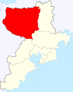 Location of Pingdu within Qingdao | |
| Country | China |
| Province | Shandong |
| Prefecture-level city | Qingdao |
| Time zone | UTC+8 (China Standard) |
| Website | 平度政务 (in Simplified Chinese) |
Pingdu (Chinese: 平度; pinyin: Píngdù) is the largest county-level city of Qingdao sub-provincial city, Shandong Province, China.
It is located in the east of the Shandong Peninsula (Jiaodong Peninsula), the heart of peninsula. It borders on Yantai and Weifang,[1] and it has an area of 3,166 km2 (1,222 sq. mi.) and a population of 1,360,000 people.
Administration
The administrative divisions of Pingdu have undergone a relatively large number of changes in the past thirty years.[2][3][4] As of 2016, Pingdu had 5 subdistricts, 12 towns and 1 other area:[5][6]
| NBS Area No. | Chinese (Simp.) | Postal Code[7] | |||
|---|---|---|---|---|---|
| Subdistricts | |||||
| 370283001000 | 东阁街道 (formerly 城关街道) | 266752 | |||
| 370283002000 | 李园街道 | 266708, 266709 | |||
| 370283003000 | 同和街道 | 266706 | |||
| 370283004000 | 凤台街道 (formerly 香店街道) | 266705 | |||
| 370283005000 | 白沙河街道 | 266738 | |||
| Towns | |||||
| 370283100000 | 麻兰镇 | 266743 | |||
| 370283101000 | 古岘镇 | 266742 | |||
| 370283102000 | 仁兆镇 | 266739, 266741 | |||
| 370283103000 | 张戈庄镇 | 266738 | |||
| 370283104000 | 郭庄镇 | 266737 | |||
| 370283105000 | 南村镇 | 266734, 266735, 266736 | |||
| 370283106000 | 兰底镇 | 266734 | |||
| 370283107000 | 万家镇 | 266729 | |||
| 370283108000 | 蓼兰镇 | 266731, 266732, 266733 | |||
| 370283109000 | 崔家集镇 | 266727, 266728 | |||
| 370283110000 | 明村镇 | 266723, 266724 | |||
| 370283111000 | 白埠镇 | 266725, 266726 | |||
| 370283112000 | 门村镇 | 266708 | |||
| 370283113000 | 田庄镇 | 266749, 266719, 266721 | |||
| 370283114000 | 马戈庄镇 | 266722 | |||
| 370283115000 | 张舍镇 | 266719 | |||
| 370283116000 | 新河镇 | 266717 | |||
| 370283117000 | 灰埠镇 | 266715, 266716 | |||
| 370283118000 | 长乐镇 | 266714 | |||
| 370283119000 | 店子镇 | 266711, 266753 | |||
| 370283120000 | 大泽山镇 | 266714 | |||
| 370283121000 | 大田镇 | 266749 | |||
| 370283122000 | 旧店镇 | 266747, 266749 | |||
| 370283123000 | 祝沟镇 | 266746 | |||
| 370283124000 | 云山镇 | 266744, 266745 | |||
| 370283125000 | 崔召镇 | 266752 | |||
| 蟠桃镇 | 266704 | ||||
| Other Areas | |||||
| 370283400000 | 平度外向型工业加工区 | 266705 | |||
Coordinates: 36°47′00″N 119°57′20″E / 36.78333°N 119.95556°E
See also
References
- ↑ baidupedia
- ↑ "2009年统计用区划代码和城乡划分代码:平度市" (in Simplified Chinese). 中华人民共和国国家统计局 National Bureau of Statistics of the People's Republic of China. 2009. Retrieved 30 January 2018.
代码 名称 370283001000 城关街道办事处 370283002000 李园街道办事处 370283003000 同和街道办事处 370283004000 香店街道办事处 370283100000 麻兰镇 370283101000 古岘镇 370283102000 仁兆镇 370283103000 张戈庄镇 370283104000 郭庄镇 370283105000 南村镇 370283106000 兰底镇 370283107000 万家镇 370283108000 蓼兰镇 370283109000 崔家集镇 370283110000 明村镇 370283111000 白埠镇 370283112000 门村镇 370283113000 田庄镇 370283114000 马戈庄镇 370283115000 张舍镇 370283116000 新河镇 370283117000 灰埠镇 370283118000 长乐镇 370283119000 店子镇 370283120000 大泽山镇 370283121000 大田镇 370283122000 旧店镇 370283123000 祝沟镇 370283124000 云山镇 370283125000 崔召镇 370283400000 平度外向型工业加工区
- ↑ "平度市概况地图" (in Simplified Chinese). 行政区划网站 [Administrative Divisions Website]. 2012-10-25. Retrieved 30 January 2018.
全市总人口137万人(2010年末)。辖4个街道、26个镇:城关街道、李园街道、同和街道、香店街道、麻兰镇、古岘镇、仁兆镇、张戈庄镇、郭庄镇、南村镇、兰底镇、万家镇、蓼兰镇、崔家集镇、明村镇、白埠镇、门村镇、田庄镇、马戈庄镇、张舍镇、新河镇、灰埠镇、长乐镇、店子镇、大泽山镇、大田镇、旧店镇、祝沟镇、云山镇、崔召镇。
- ↑ "山东青岛平度市" (in Simplified Chinese). 博雅地名网. Retrieved 30 January 2018.
灰埠镇
- ↑ "行政区划" (in Simplified Chinese). 平度市委、市政府. Retrieved 30 January 2018.
开发区 凤台街道 同和街道 李园街道 东阁街道 白沙河街道 南村镇 蓼兰镇 崔家集镇 明村镇 田庄镇 新河镇 店子镇 大泽山镇 旧店镇 云山镇 古岘镇 仁兆镇
- ↑ "2016年统计用区划代码和城乡划分代码:平度市" (in Simplified Chinese). 中华人民共和国国家统计局 National Bureau of Statistics of the People's Republic of China. 2016. Retrieved 30 January 2018.
统计用区划代码 名称 370283001000 东阁街道办事处 370283002000 李园街道办事处 370283003000 同和街道办事处 370283004000 凤台街道办事处 370283005000 白沙河街道办事处 370283101000 古岘镇 370283102000 仁兆镇 370283105000 南村镇 370283108000 蓼兰镇 370283109000 崔家集镇 370283110000 明村镇 370283113000 田庄镇 370283116000 新河镇 370283119000 店子镇 370283120000 大泽山镇 370283122000 旧店镇 370283124000 云山镇 370283400000 平度外向型工业加工区
- ↑ 中国地质邮政编码簿(2015). 中国邮政集团公司. 2015. p. 470.
| Sub-provincial cities |
| ||||||||||||||||||||||||||||||
|---|---|---|---|---|---|---|---|---|---|---|---|---|---|---|---|---|---|---|---|---|---|---|---|---|---|---|---|---|---|---|---|
| Prefecture-level cities |
| ||||||||||||||||||||||||||||||
| |||||||||||||||||||||||||||||||
This article is issued from
Wikipedia.
The text is licensed under Creative Commons - Attribution - Sharealike.
Additional terms may apply for the media files.