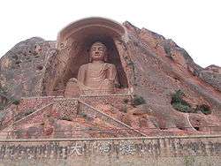
Guyuan
| Guyuan 固原市 · ﻗُﻮْﻳُﻮًا شِ | |
|---|---|
| Prefecture-level city | |
 | |
.png) Guyuan City (yellow) within Ningxia | |
| Coordinates: 36°01′N 106°15′E / 36.017°N 106.250°ECoordinates: 36°01′N 106°15′E / 36.017°N 106.250°E | |
| Country | People's Republic of China |
| Region | Ningxia |
| Municipal seat | Yuanzhou District |
| Area | |
| • Total | 14,412.83 km2 (5,564.82 sq mi) |
| Elevation | 1,777 m (5,830 ft) |
| Population (2007) | |
| • Total | 1,455,200 |
| • Density | 100/km2 (260/sq mi) |
| Time zone | UTC+8 (China Standard) |
| Postal code | 756000 |
| Area code(s) | (0)954 |
| ISO 3166 code | CN-NX-04 |
| Licence plate prefixes | 宁D |
| Website |
www |

![]()
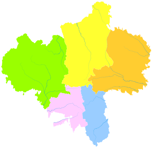
Administrative divisions
| Map | ||||||
|---|---|---|---|---|---|---|
| Name | Hanzi | Hanyu Pinyin | Xiao'erjing | Population (2003 est.) | Area (km²) | Density (/km²) |
| Yuanzhou District | 原州区 | Yuánzhōu Qū | ﻳُﻮًاﺟِﻮْ ٿُو | 490,000 | 1,965 | 99 |
| Xiji County | 西吉县 | Xījí Xiàn | ثِکِ ﺷِﯿًﺎ | 460,000 | 3,985 | 115 |
| Longde County | 隆德县 | Lóngdé Xiàn | ﻟْﻮدْ ﺷِﯿًﺎ | 190,000 | 1,269 | 150 |
| Jingyuan County | 泾源县 | Jīngyuán Xiàn | دٍﻳُﻮًا ﺷِﯿًﺎ | 120,000 | 961 | 125 |
| Pengyang County | 彭阳县 | Péngyáng Xiàn | پْعیْا ﺷِﯿًﺎ | 250,000 | 3,241 | 77 |
Geography and climate
Guyuan has a monsoon-influenced humid continental climate (Köppen Dwb), with long, cold, dry winters, and warm, rainier summers. With temperatures cooled by the elevation that exceeds 1,770 metres (5,810 ft), highs average slightly below freezing in January and reach only 25 °C (77 °F) in July. Much of the year's precipitation is delivered from June to September.
| Climate data for Guyuan (1971−2000) | |||||||||||||
|---|---|---|---|---|---|---|---|---|---|---|---|---|---|
| Month | Jan | Feb | Mar | Apr | May | Jun | Jul | Aug | Sep | Oct | Nov | Dec | Year |
| Record high °C (°F) | 13.1 (55.6) |
18.3 (64.9) |
22.8 (73) |
30.1 (86.2) |
31.5 (88.7) |
32.2 (90) |
34.6 (94.3) |
33.8 (92.8) |
31.5 (88.7) |
24.8 (76.6) |
20.2 (68.4) |
14.1 (57.4) |
34.6 (94.3) |
| Average high °C (°F) | −0.4 (31.3) |
2.1 (35.8) |
7.4 (45.3) |
15.1 (59.2) |
19.9 (67.8) |
23.2 (73.8) |
25.0 (77) |
23.7 (74.7) |
18.7 (65.7) |
13.0 (55.4) |
6.9 (44.4) |
1.5 (34.7) |
13.0 (55.4) |
| Daily mean °C (°F) | −8.1 (17.4) |
−4.9 (23.2) |
1.0 (33.8) |
8.2 (46.8) |
13.4 (56.1) |
17.0 (62.6) |
18.9 (66) |
17.8 (64) |
12.8 (55) |
6.6 (43.9) |
−0.3 (31.5) |
−6.0 (21.2) |
6.4 (43.5) |
| Average low °C (°F) | −14.2 (6.4) |
−10.6 (12.9) |
−4.4 (24.1) |
1.9 (35.4) |
6.8 (44.2) |
10.3 (50.5) |
12.9 (55.2) |
12.3 (54.1) |
7.7 (45.9) |
1.6 (34.9) |
−5.5 (22.1) |
−11.7 (10.9) |
0.6 (33.1) |
| Record low °C (°F) | −27 (−17) |
−23.2 (−9.8) |
−18.9 (−2) |
−12.0 (10.4) |
−6.4 (20.5) |
0.1 (32.2) |
4.0 (39.2) |
3.1 (37.6) |
−2.3 (27.9) |
−11.2 (11.8) |
−20.0 (−4) |
−30.9 (−23.6) |
−30.9 (−23.6) |
| Average precipitation mm (inches) | 3.0 (0.118) |
4.0 (0.157) |
11.8 (0.465) |
24.9 (0.98) |
43.8 (1.724) |
61.8 (2.433) |
88.8 (3.496) |
102.2 (4.024) |
56.1 (2.209) |
29.7 (1.169) |
7.0 (0.276) |
2.1 (0.083) |
435.2 (17.134) |
| Average precipitation days (≥ 0.1 mm) | 2.1 | 2.9 | 4.3 | 3.4 | 5.9 | 8.7 | 12.2 | 11.9 | 8.1 | 4.4 | 2.6 | 1.9 | 68.4 |
| Source: Weather China | |||||||||||||
Transportation
The city is served by Guyuan Liupanshan Airport, though travelers may also choose Zhongwei Xiangshan Airport and Yinchuan Hedong Airport as well. The Fuyin Expressway passes through the area on its way to the regional capital of Yinchuan.
As there is no high-speed railways to Guyuan, one of the fastest ways to travel to Guyuan from a major city is an approximately 4-hour drive from Yinchuan,[3] which is actually faster than traveling by train, which takes at least 5 hours.[4]
References
- ↑ ^ http://www.travelchinaguide.com/cityguides/ningxia/guyuan/
- ↑ "Photographer captures the beauty of Xihaigu".
- ↑ "Guyuan – Travel guide at Wikivoyage". en.wikivoyage.org. Retrieved 2018-10-02.
- ↑ "Trip.com Official Site | 1+ million hotels. Flights to 5,000+ destinations". www.trip.com. Retrieved 2018-10-02.