Nyingchi
| Nyingchi 林芝市 ཉིང་ཁྲི་གྲོང་ཁྱེར། | |
|---|---|
| Prefecture-level city | |
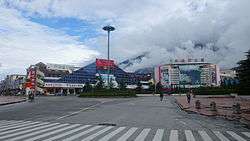 The urban center Bayi Town in Bayi District | |
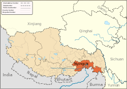 prefecture (orange) in Tibet Autonomous Region (light-orange) | |
| Country | People's Republic of China |
| Autonomous region | Tibet |
| city seat | Bayi District (Bayi Town) |
| Area | |
| • Total | 116,175 km2 (44,855 sq mi) |
| Population | |
| • Total | 195,109 |
| • Density | 1.7/km2 (4.3/sq mi) |
| Time zone | UTC+8 (China Standard) |
| ISO 3166 code | CN-XZ-04 |
| Nyingchi | |||||||
| Chinese name | |||||||
|---|---|---|---|---|---|---|---|
| Chinese | 林芝 | ||||||
| |||||||
| Tibetan name | |||||||
| Tibetan | ཉིང་ཁྲི་ས། | ||||||
| |||||||
Nyingchi, also known as Linzhi, is a prefecture-level city in southeast of the Tibet Autonomous Region. The administrative seat of Nyingchi is Bayi District. The Chinese claim part of Arunachal Pradesh, which is one of the states of India, as part of the prefecture. (See South Tibet dispute.)
Nyingchi is the location of Buchu Monastery.
Geography and landmarks
The prefecture-level city contains the Namcha Barwa Peak, and the Yarlung Tsangpo Grand Canyon, located in Mêdog County, which attracts significant tourism and geoscientific and biological study to the area.
Approximately 90 kilometers west of Gongbo'gyamda County, is the alpine Basum Lake in the upper catchment area of the Ba River, the largest tributary of the Nyang River lying on average about 3,538 metres (11,608 ft) above sea level. The lake surface is on average about 3,538 meters above sea level. Covering an area of 25.9 km2 (10.0 sq mi), the surrounding is populated by a diverse wildlife including leopards, bears, goats, musk deer and Tibetan snow lions. In 1997, the Basum Lake was listed by the World Tourism Organization as a top tourist attraction. The lake also contains an inlet with a Gelug monastery. East of Nyingchi County, is the Seche La Mountain, a mountain of the Nyainqentanglha Mountain Range, which forms part of the watershed of the Nyang River and the Polung Zangbo River. Benri La Mountain near the small town of Dagze is a known sacred site of the Tibetan Bon Sect. Considered by Tibetans as one of the four great holy mountains in Tibet, on every tenth day of the eighth month of the Tibetan calendar, a day of intense worshipping called "Nangbolhasoi," is performed (meaning "seeking for treasures from immortals.")
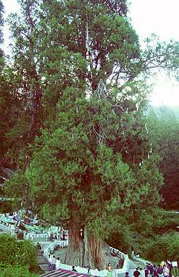
Bayi Town is the administrative seat of Nyingchi, located 406 kilometers east of Lhasa. The vicinity is known for its cypresses which can grow up to 30 meters.
The Nangpo Gully, located about 50 kilometers northwest from Gongbo'gyamda County, is one of the northern tributaries of the Nyang River and its upper stream is formed by the confluence of Yangwo, Gyixing and Boru streams. The area contains the hot springs the Nun's Hot Springs, the Lama's Hot Springs and the Boru Hot Springs and many old pine trees and cypresses, and caves. At the foot of the gully is the Yellow sect (Gelug) Bagar Monastery, which was built during the period of the Fifth Dalai Lama. The cave above the monastery contains murals of holy animals and Buddhist images, and below the cave is the famous karst springs. show jade-red bear branches, forming a "Red Cloud Gully" of 5 kilometers. The cobbles in the bed of the stream look like scattered pearls, so this place is also called "Pearl Shoal." The scenes here are unique and beautiful.
Burqug Lamaling Monastery is located on the third terrace on the left bank of the lower reaches of the Nyang River.
Köppen-Geiger climate classification system classifies its climate as subtropical highland (Cwb).[1]
| Climate data for Nyingchi, Tibet Autonomous Region | |||||||||||||
|---|---|---|---|---|---|---|---|---|---|---|---|---|---|
| Month | Jan | Feb | Mar | Apr | May | Jun | Jul | Aug | Sep | Oct | Nov | Dec | Year |
| Average high °C (°F) | 8.1 (46.6) |
9.7 (49.5) |
13.3 (55.9) |
16.3 (61.3) |
19.0 (66.2) |
21.4 (70.5) |
22.3 (72.1) |
22.3 (72.1) |
20.5 (68.9) |
17.4 (63.3) |
13.1 (55.6) |
9.6 (49.3) |
16.1 (60.9) |
| Daily mean °C (°F) | 1.3 (34.3) |
3.4 (38.1) |
6.7 (44.1) |
9.6 (49.3) |
12.8 (55) |
15.7 (60.3) |
16.9 (62.4) |
16.5 (61.7) |
14.9 (58.8) |
11.1 (52) |
6.0 (42.8) |
2.5 (36.5) |
9.8 (49.6) |
| Average low °C (°F) | −5.5 (22.1) |
−2.9 (26.8) |
0.1 (32.2) |
3.0 (37.4) |
6.6 (43.9) |
10.1 (50.2) |
11.5 (52.7) |
10.8 (51.4) |
9.4 (48.9) |
4.8 (40.6) |
−1.0 (30.2) |
−4.6 (23.7) |
3.5 (38.3) |
| Average precipitation mm (inches) | 3 (0.12) |
5 (0.2) |
16 (0.63) |
44 (1.73) |
74 (2.91) |
133 (5.24) |
134 (5.28) |
115 (4.53) |
109 (4.29) |
38 (1.5) |
6 (0.24) |
2 (0.08) |
679 (26.75) |
| Source: Climate-Data.org (altitude: 2988m)[1] | |||||||||||||
Forestry and agriculture
"According to local forestry officials, Nyingchi hosts the country's largest primitive forest region that covers 26.4 billion cubic metres, storing over 800 million cubic metres of wood."[2] The forests of Bomi, Zayu and Loyu have ancient dragon spruces which reach heights of over 80 metres and diameters of 2.5 metres. Wildlife species include "the Bengal tiger, leopard, bear, snub-nosed monkey, antelope and lesser panda."[2]
"There are over 2,000 species of higher plants, including some 100 species of xylophyta, 165 species of medical herbs and fungus. Crops include "rice, peanut, apple, orange, banana, lemon." Agricultural products include medicinal materials, "edible fungus, orange, tangerine, sugar cane, honey peach, apple, pear, grape, walnut and other fruits." [2]
Transportation
It takes about 10 hours to travel from Lhasa to Nyingchi by road. The railway between Lhasa and Nyingchi has been under construction since late 2014. It is estimated that it will take about 2 or 3 hours from Lhasa to Nyingchi when the railway come into operation.[3]
An airport was opened in Nyingchi in March 2017, which may be used to support both commercial air traffic and the People's Liberation Army Air Force.[4]
Tourism
Guangdong province announced that it plans to invest more than RMB 400 million (US$63 million) in Nyingchi's tourism industry. According to the plan, Guangdong will help build 22 "prosperous model villages" in Nyingchi in counties such as Bomê and Zayü.[5]
Administrative subdivisions
The two counties of Zayü (察隅县) and Mêdog (墨脱县), collectively called South Tibet, are considered by the Chinese government to be under Chinese jurisdiction, however they are de facto under the control of India's state of Arunachal Pradesh.
| Map | ||||||||
|---|---|---|---|---|---|---|---|---|
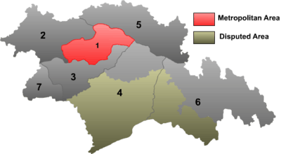 | ||||||||
| # | Name | Hanzi | Hanyu Pinyin | Tibetan | Wylie | Population (2010 Census) | Area (km²) | Density (/km²) |
| 1 | Bayi District | 巴宜区 | Bāyí Qū | བྲག་ཡིབ་ཆུས། | brag yib chus | 54,702 | 8,536 | 6.40 |
| 2 | Gongbo'gyamda County | 工布江达县 | Gōngbùjiāngdá Xiàn | ཀོང་པོ་རྒྱ་མདའ་རྫོང་། | kong po rgya mda' rdzong | 29,929 | 12,960 | 2.30 |
| 3 | Mainling County | 米林县 | Mǐlín Xiàn | སྨན་གླིང་རྫོང་། | sman gling rdzong | 22,834 | 9,507 | 2.40 |
| 4 | Mêdog County | 墨脱县 | Mòtuō Xiàn | མེ་ཏོག་རྫོང་། | me tog rdzong | 10,963 | 31,394 | 0.34 |
| 5 | Bomê County | 波密县 | Bōmì Xiàn | སྤོ་མེས་རྫོང་། | spo mes rdzong | 33,480 | 16,770 | 1.99 |
| 6 | Zayü County | 察隅县 | Cháyú Xiàn | རྫ་ཡུལ་རྫོང་། | rdza yul rdzong | 27,255 | 31,305 | 0.87 |
| 7 | Nang County | 朗县 | Lǎng Xiàn | སྣང་རྫོང་། | snang rdzong | 15,946 | 4,114 | 3.87 |
References
- 1 2 "Temperature, Climate graph, Climate table for Nyingchi". Climate-Data.org. Retrieved 2017-03-20.
- 1 2 3 "Tibet travel guide of Nyingchi Region, Bayi Town". Retrieved 2013-10-20.
- ↑ "Nyingchi Travel" ChinaTour.net Accessed 2013-8-11
- ↑ Singh, Mandeep (March 28, 2017). "A Quick Note On Rising People's Liberation Army Air Force Activities in Tibet". Delhi Defence Review. Retrieved March 29, 2017.
In March 2017, China opened an airport in Nyingchi, Tibet Autonomous Region (TAR), only 30 kilometers from the Line of Actual control (LAC) with India. This is the second largest airport in TAR and is closer to LAC than any other airport in the region. While the airport terminal is meant for civil aviation, it is known that Chinese airports, especially those in TAR, are essentially ‘dual-use’ – meant for both civil and military use. As Xinhua had announced in 2015, China is carrying out an ‘integration’ of civil-military airports in order to ‘strengthen aviation safety and combat support capabilities’. This will include joint maintenance of airport support facilities, joint flight safety support and joint airport management. Incidentally, one of the first airports to implement the aforesaid ‘integration’ was the Lhasa Gonggar Airport in TAR, having completed the process in 2015 itself. It can therefore be said that Nyingchi airport gives the People’s Liberation Army Air Force (PLAAF) an additional operational base in TAR, and one that is right opposite the Indian state of Arunachal Pradesh Overall, this development is in keeping with the recent increase in the tempo of PLAAF activities in TAR.
- ↑ "China plans 'Swiss makeover' for tourism in southeast Tibet". CNN Travel. 2012-06-29. Retrieved 2013-10-20.
External links
- Tibetinfor.com
- Nyingchi information and travel guides at Nyingchi.com
Coordinates: 29°34′37.20″N 94°29′02.40″E / 29.5770000°N 94.4840000°E