Zalantun
| Zalantun 扎兰屯市 • ᠵᠠᠯᠠᠨᠠᠢ᠌ᠯᠬᠣᠲᠠ | |
|---|---|
| County-level city | |
 | |
| Nickname(s): 塞北小江南 (Little Jiangnan of Saibei/Jiangnan beyond the Great Wall) | |
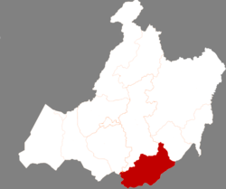 Zalantun in Hulunbuir | |
 Zalantun Location in Inner Mongolia | |
| Coordinates: 48°01′37″N 122°42′29″E / 48.027°N 122.708°ECoordinates: 48°01′37″N 122°42′29″E / 48.027°N 122.708°E | |
| Country | People's Republic of China |
| Autonomous region | Inner Mongolia |
| Prefecture-level city | Hulunbuir |
| Time zone | UTC+8 (China Standard) |
| Postal code | 162650 |
| Area code(s) | 0470 |
| Website |
www |
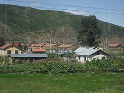
Zalantun (Manchu J̌alan Ai"l or Jalan Tun) or Zhalantun (simplified Chinese: 扎兰屯; traditional Chinese: 扎蘭屯; pinyin: Zhālántún; Mongolian: ᠵᠠᠯᠠᠨ ᠠᠢ᠌ᠯ ᠬᠣᠲᠠ Жалан-Айл хот), is a city with an estimated population of 132,408 and administrative division of Hulunbuir Prefecture-level city, Inner Mongolia, China. It is in the northeastern part of Inner Mongolia, in the southeastern foothills of the Greater Khingan mountains, bordering Heilongjiang province to the east. It is an area which has a number of forests and streams, as well as the Yalu River, not to be confused with the Yalu River on the Sino-Korean border. It is known for its hunting and fishing.
History
Zalantun was formerly known as Buteha (布特哈; Bùtèhā), and the city was made into an administrative centre in the Kangxi era. In 1929, Buteha was renamed as Yalu county (雅鲁县; Yǎlǔ Xiàn) because the Yalu River runs through it, but in 1933 it became the Zalantun Banner (扎兰屯旗; Zhālántún Qí). In 1983, Zalantun ceased to be a banner and became a part of Hulunbuir, remaining so today.
Climate
| Climate data for Zhalantun (1971–2000) | |||||||||||||
|---|---|---|---|---|---|---|---|---|---|---|---|---|---|
| Month | Jan | Feb | Mar | Apr | May | Jun | Jul | Aug | Sep | Oct | Nov | Dec | Year |
| Record high °C (°F) | 4.3 (39.7) |
10.2 (50.4) |
22.1 (71.8) |
30.7 (87.3) |
38.0 (100.4) |
39.5 (103.1) |
38.7 (101.7) |
35.2 (95.4) |
31.8 (89.2) |
29.7 (85.5) |
15.8 (60.4) |
5.9 (42.6) |
39.5 (103.1) |
| Daily mean °C (°F) | −17 (1) |
−12.6 (9.3) |
−4.5 (23.9) |
5.4 (41.7) |
13.7 (56.7) |
19.0 (66.2) |
21.4 (70.5) |
19.3 (66.7) |
12.6 (54.7) |
3.7 (38.7) |
−7.3 (18.9) |
−14.9 (5.2) |
3.23 (37.82) |
| Record low °C (°F) | −34.7 (−30.5) |
−31.3 (−24.3) |
−26.7 (−16.1) |
−14.2 (6.4) |
−6.3 (20.7) |
2.8 (37) |
8.0 (46.4) |
1.6 (34.9) |
−5.7 (21.7) |
−15.9 (3.4) |
−25.3 (−13.5) |
−34.5 (−30.1) |
−34.7 (−30.5) |
| Average precipitation mm (inches) | 1.1 (0.043) |
1.2 (0.047) |
3.2 (0.126) |
17.1 (0.673) |
32.9 (1.295) |
95.5 (3.76) |
162.0 (6.378) |
116.4 (4.583) |
51.4 (2.024) |
18.5 (0.728) |
3.9 (0.154) |
2.4 (0.094) |
505.6 (19.905) |
| Average precipitation days (≥ 0.1 mm) | 2.2 | 2.4 | 3.3 | 4.9 | 7.9 | 13.8 | 15.7 | 13.2 | 9.4 | 4.5 | 3.1 | 3.9 | 84.3 |
| Source: Weather China | |||||||||||||
Economy
Zalantun's economy is based primarily on tourism and agriculture, livestock and forestry. The Harbin-Manzhouli Railway traverses the district. It is rich in food grains, particularly wheat, soy and corn, as well as cattle, sheep, horse and other livestock. It has an industrial base in paper production, candy production, and wool. It has an annual average temperature of 2 °C and an average annual precipitation of 480mm. The northwest portion of the district consists of natural forests in the Greater Khingan mountains.
Transport
Zhalantun Chengjisihan Airport was opened in December 2016.[1]
References
- ↑ "内蒙古扎兰屯成吉思汗机场投入使用". Civil Aviation Administration of China (in Chinese). 28 December 2016.