Dangyang
| Dangyang 当阳市 | |
|---|---|
| County-level city | |
 Dangyang Yuquan Temple | |
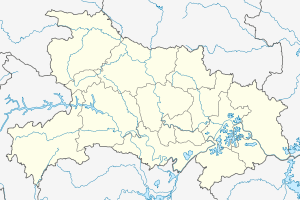 Dangyang Location in Hubei | |
| Coordinates: 30°50′N 111°47′E / 30.833°N 111.783°ECoordinates: 30°50′N 111°47′E / 30.833°N 111.783°E | |
| Country | People's Republic of China |
| Province | Hubei |
| Prefecture-level city | Yichang |
| Area[1] | |
| • Total | 2,038 km2 (787 sq mi) |
| Population (2010)[1] | |
| • Total | 468,293 |
| • Density | 230/km2 (600/sq mi) |
| Website |
hbdy |
Dangyang (simplified Chinese: 当阳; traditional Chinese: 當陽; pinyin: Dāngyáng) is a city in western Hubei province, People's Republic of China, lying 70 kilometres (43 mi) east of the Gezhouba Dam on the Yangtze River. During the Western Han Dynasty (206-24 BC). Emperor Jing of Han established an administration in Dangyang on an area of 2,000 square kilometres (770 sq mi). In 1988 the State Council of the People's Republic of China elevated this from a county to a county-level city, and is currently under the administration of Yichang City.[1]
Dangyang used to be a strategic point in ancient wars. Sun Bin and Pang Juan, two famous strategists of the Warring States period (475-221 BC) studied military affairs from Gui Guzi at Daxian Cave in Dangyang. The Green Woods Uprising was launched in Dangyang and several battles were fought in Dangyang during the Three Kingdoms Period (AD 220-280).
Today Dangyang is a rapidly growing modern city with a population of over 100,000. While agriculture remains a key industry in Dangyang, industrial production now includes output in the areas of foodstuffs, building materials, textiles, chemicals, electronics, machinery, energy and packaging.
On August 11, 2016, an explosion at a chemical factory in Dangyang killed 21 people and injured at least 5.[2]
Administrative divisions
Seven towns:
References
- 1 2 3 4 当阳市历史沿革 [Dangyang City Historical Development]. 行政区划网站 www.xzqh.org (in Simplified Chinese). 行政区划网站/区划地名网站 (Administrative Divisions Web/District Geographic Names Web). 14 July 2014. Retrieved 11 October 2018.
1988年10月22日,国务院批准撤销当阳县,设立当阳市(县级)。{...}1996年,当阳市面积2038平方千米,{...}淯溪镇、{...}2010年第六次人口普查,当阳市常住总人口468293人,其中:玉阳街道104568人,坝陵街道54384人,玉泉街道45390人,两河镇32412人,河溶镇51339人,育溪镇50205人,庙前镇36917人,王店镇39481人,半月镇32749人,草埠湖镇20848人。
- ↑ News, 163.com. "湖北当阳一公司爆炸" (in Chinese). Retrieved 12 August 2016.
- ↑ 2017年统计用区划代码和城乡划分代码:当阳市 [2017 Statistical Area Numbers and Rural-Urban Area Numbers: Dangyang City]. National Bureau of Statistics of the People's Republic of China. 2017. Retrieved 11 October 2018.
统计用区划代码 名称 420582001000 当阳市玉阳街道办事处 420582002000 当阳市坝陵街道办事处 420582003000 当阳市玉泉街道办事处 420582101000 当阳市两河镇 420582102000 当阳市河溶镇 420582103000 当阳市淯溪镇 420582104000 当阳市庙前镇 420582105000 当阳市王店镇 420582106000 当阳市半月镇 420582107000 当阳市草埠湖镇
- ↑ 行政区划 [Administrative Divisions]. “当阳市人民政府”网站 (in Simplified Chinese). 当阳市人民政府, 中国宜昌网站群运维服务中心. Retrieved 11 October 2018.
全市辖7个建制镇,3个城区办事处。7个镇是两河、河溶、淯溪、庙前、王店、半月、草埠湖,3个办事处是玉阳、坝陵、玉泉。全市155个村民委员会、18个社区委员会。其中:玉阳办事处12个村、6个社区;坝陵办事处17个村、2个社区;玉泉办事处15个村、1个社区;两河镇12个村、1个社区;河溶镇19个村、1个社区;淯溪镇23个村、2个社区;庙前镇18个村、2个社区;王店镇15个村、1个社区;半月镇10个村、1个社区;草埠湖镇14个村,1个社区。
- ↑ 现代汉语规范词典(第3版). [A Standard Dictionary of Current Chinese (Third Edition).]. 北京. Beijing: 外语教学与研究出版社. Foreign Language Teaching and Research Press. May 2014. p. 1615. ISBN 978-7-513-54562-4.
淯 yù [淯溪] yùxī 名 地名,在湖北。
External links
| Wikimedia Commons has media related to Dangyang. |