Huainan
| Huainan 淮南市 | |
|---|---|
| Prefecture-level city | |
 | |
.png) Location of Huainan City jurisdiction in Anhui | |
| Country | People's Republic of China |
| Province | Anhui |
| County-level divisions | 7 |
| Township-level divisions | 66 |
| Municipal seat |
Tianjia'an District (32°37′N 116°59′E / 32.617°N 116.983°E) |
| Government | |
| • CPC Secretary | Shen Qiang (沈强) |
| • Mayor | Wang Hong (王宏) |
| Area | |
| • Prefecture-level city | 5,533 km2 (2,136 sq mi) |
| • Urban | 1,492.3 km2 (576.2 sq mi) |
| • Metro | 1,985.6 km2 (766.6 sq mi) |
| Population (2010 census) | |
| • Prefecture-level city | 2,333,896 |
| • Density | 420/km2 (1,100/sq mi) |
| • Urban | 1,666,826 |
| • Urban density | 1,100/km2 (2,900/sq mi) |
| • Metro | 1,938,212 |
| • Metro density | 980/km2 (2,500/sq mi) |
| Time zone | UTC+8 (China Standard) |
| Area code(s) | 554 |
| ISO 3166 code | CN-AH-04 |
| License Plate Prefix | 皖D |
| Huainan | |||||||||
 | |||||||||
| Chinese | 淮南 | ||||||||
|---|---|---|---|---|---|---|---|---|---|
| Literal meaning | [Land(s)] South of the Huai River | ||||||||
| |||||||||
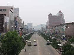
Huainan is a prefecture-level city with 2,334,000 inhabitants in central Anhui Province, People’s Republic of China. It is named for the former Principality of Huainan. It borders the provincial capital of Hefei to the south, Lu'an to the southwest, Fuyang to the west, Bozhou to the northwest, Bengbu to the northeast and Chuzhou to the east. Huainan is one of the core cities of Hefei Metropolitan Circle[1] and is known for its coal industry and thermal power plants. Its built-up area is home to 1,938,212 inhabitants in 2010.[2] Its city flower is Rosa chinensis and its city tree is Platanus. It is also considered to be the hometown and birthplace of tofu.[3][4]
Administration
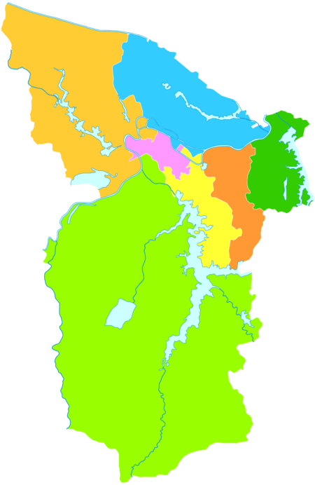
The prefecture-level city of Huainan administers seven county-level divisions, including five districts and two counties.
- Tianjia'an District (田家庵区)
- Panji District (潘集区)
- Xiejiaji District (谢家集区)
- Datong District (大通区)
- Bagongshan District (八公山区)
- Fengtai County (凤台县)
- Shou County (寿县)
These are further divided into 66 township-level divisions, including 24 towns, 23 townships and 19 subdistricts.
| Map | |||||
|---|---|---|---|---|---|
High-tech development zone
- Shannan New Area (山南新区)
Geography
The urban centre is located on a plain on the south bank of the Huai River, bordering Gaotang Lake on the east and forested hill area on the south. To the west are Bagongshan District and Shou County.
Climate
| Climate data for Huainan | |||||||||||||
|---|---|---|---|---|---|---|---|---|---|---|---|---|---|
| Month | Jan | Feb | Mar | Apr | May | Jun | Jul | Aug | Sep | Oct | Nov | Dec | Year |
| Average high °C (°F) | 6.8 (44.2) |
9.2 (48.6) |
14.1 (57.4) |
21.0 (69.8) |
26.4 (79.5) |
30.1 (86.2) |
32.0 (89.6) |
31.0 (87.8) |
27.2 (81) |
21.9 (71.4) |
15.4 (59.7) |
9.0 (48.2) |
20.3 (68.5) |
| Average low °C (°F) | −1 (30) |
1.1 (34) |
5.3 (41.5) |
11.3 (52.3) |
16.8 (62.2) |
21.5 (70.7) |
24.7 (76.5) |
23.6 (74.5) |
19.0 (66.2) |
12.8 (55) |
6.4 (43.5) |
0.7 (33.3) |
11.9 (53.4) |
| Average precipitation mm (inches) | 24.2 (0.953) |
30.5 (1.201) |
50.6 (1.992) |
36.4 (1.433) |
60.5 (2.382) |
100.7 (3.965) |
162.0 (6.378) |
101.8 (4.008) |
46.0 (1.811) |
39.5 (1.555) |
29.1 (1.146) |
16.7 (0.657) |
698.0 (27.48) |
| Source: | |||||||||||||
Economy
Huainan is a major production center for coal, with an output of 43.28 million tons in 2006.
The city hosted the 17th China Tofu Cultural Festival on September 15–17, 2010, including the National Bean Products Exhibition.[5]
Education
- Anhui University of Science and Technology (安徽理工大学) official website
- Huainan Normal University (淮南师范学院) official website
- Huainan Union University (淮南联合大学) official website
- Huainan Vocational Technical College (淮南职业技术学院) official website
- Anhui Industry&Trade Vocational Technical College (安徽工贸职业技术学院) official website
- Anhui Modern Information Engineering College (安徽现代信息工程职业学院) official website
The key high schools:
- Huainan No.1 high school (淮南一中)淮南一中官网
- Huainan No.2 high school (淮南二中)
- Huainan No.5 high school (淮南五中)
- Huainan No.4 high school (淮南四中)
- Fengtai No.1 high school (凤台一中)
- Shouxian No.1 high school (寿县一中)
Transportation
East of the city a bridge crosses the Huai River, shared by the Fuyang-Huainan Railway and highway S225. Near the city centre, a ferry provides connection to the (rural) north bank of the Huai River.
Rail
- Huainan Railway Station, terminus of the Fuyang-Huainan Railway and Huainan Railway
- Huainan East Railway Station (high-speed services) on the Hefei–Bengbu High-Speed Railway
Highway
Expressways


National Highways
See also
References
- ↑ http://xxgk.ah.gov.cn/UserData/DocHtml/731/2016/12/15/572807095431.html
- ↑ http://www.citypopulation.de/php/china-anhui-admin.php
- ↑ "Huainan Tofu".
- ↑ William Shurtleff; Akiko Aoyagi (May 2013). History of Tofu and Tofu Products (965 CE to 2013). Soyinfo Center. p. 55. ISBN 978-1-928914-55-6.
- ↑ http://english.anhuinews.com/system/2010/09/16/003356173.shtml
External links
| Wikimedia Commons has media related to Huainan. |
- Government website of Huainan (in Chinese) (in English) (in Korean)
- http://www.ah.xinhuanet.com/huainan/index.htm (in Chinese)