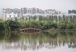
Xichang
| Xichang 西昌市 · ꀒꎂꏃ | |
|---|---|
| County-level city | |
 | |
.png) Location of Xichang City jurisdiction (red) within Liangshan Prefecture (yellow) and Sichuan | |
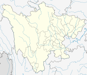 Xichang Location in Sichuan | |
| Coordinates: 27°53′40″N 102°15′52″E / 27.89444°N 102.26444°ECoordinates: 27°53′40″N 102°15′52″E / 27.89444°N 102.26444°E | |
| Country | People's Republic of China |
| Province | Sichuan |
| Prefecture | Liangshan |
| Municipal seat | Beicheng Subdistrict (北城街道) |
| Area | |
| • Total | 2,651 km2 (1,024 sq mi) |
| Elevation | 1,542 m (5,059 ft) |
| Population (2012) | |
| • Total | 481,796 |
| • Density | 180/km2 (470/sq mi) |
| Time zone | UTC+8 (China Standard) |
| Postal code | 615000 |
| Area code(s) | 0834 |
| Xichang | |||||||
 | |||||||
| Chinese name | |||||||
|---|---|---|---|---|---|---|---|
| Chinese | 西昌 | ||||||
| Literal meaning | Western Prosperity | ||||||
| |||||||
| Yi name | |||||||
| Yi |
ꀒꎂ Romanisation:(Op Rro) | ||||||
| Former names | |||||||||
| Jiandu | |||||||||
|---|---|---|---|---|---|---|---|---|---|
| Chinese | 建都 | ||||||||
| Literal meaning | Establishing Capital | ||||||||
| |||||||||
| Jianchang | |||||||||
| Chinese | 建昌 | ||||||||
| Literal meaning | Establishing Prosperity | ||||||||
| |||||||||
Xichang, formerly known as Jiandu[lower-alpha 1] and Jianchang,[lower-alpha 2] is a city in and the seat of the Liangshan Yi Autonomous Prefecture, in the south of Sichuan Province, China. In 2012 it had a population of 481,796.
Geography
Xichang lies in a mountainous region of far southern Sichuan. The city is just northeast of the prefecture-level city of Panzhihua. The Anning River is the main river in the area. It is an affluent of the Yalong, Jinsha, and Yangtze rivers. It lies near Qionghai Lake.
Climate
Owing to its low latitude and high elevation, Xichang has a monsoon-influenced humid subtropical climate (Köppen Cwa) milder and far sunnier than the Sichuan Basin, with mild, very sunny and dry winters, and very warm, rainy summers. The monthly 24-hour average temperature ranges from 9.9 °C (49.8 °F) in January to 22.6 °C (72.7 °F) in July, and the annual mean is 17.15 °C (62.9 °F). Over 60% of the 1,010 mm (40 in) annual precipitation occurs from June to August. With monthly percent possible sunshine ranging from 36% in September to 72% in January, the city receives 2,367 hours of bright sunshine annually.
| Climate data for Xichang (1981−2010) | |||||||||||||
|---|---|---|---|---|---|---|---|---|---|---|---|---|---|
| Month | Jan | Feb | Mar | Apr | May | Jun | Jul | Aug | Sep | Oct | Nov | Dec | Year |
| Record high °C (°F) | 26.0 (78.8) |
28.7 (83.7) |
33.5 (92.3) |
35.5 (95.9) |
36.6 (97.9) |
36.0 (96.8) |
35.5 (95.9) |
35.1 (95.2) |
34.9 (94.8) |
30.9 (87.6) |
27.8 (82) |
24.8 (76.6) |
36.6 (97.9) |
| Average high °C (°F) | 17.0 (62.6) |
19.9 (67.8) |
23.8 (74.8) |
26.9 (80.4) |
27.9 (82.2) |
27.1 (80.8) |
27.9 (82.2) |
28.0 (82.4) |
25.3 (77.5) |
22.5 (72.5) |
19.6 (67.3) |
16.8 (62.2) |
23.6 (74.4) |
| Daily mean °C (°F) | 9.9 (49.8) |
12.6 (54.7) |
16.1 (61) |
19.2 (66.6) |
21.2 (70.2) |
21.7 (71.1) |
22.6 (72.7) |
22.3 (72.1) |
19.9 (67.8) |
17.0 (62.6) |
13.3 (55.9) |
10.0 (50) |
17.2 (62.9) |
| Average low °C (°F) | 4.6 (40.3) |
6.7 (44.1) |
10.0 (50) |
13.2 (55.8) |
16.0 (60.8) |
18.0 (64.4) |
19.0 (66.2) |
18.5 (65.3) |
16.6 (61.9) |
13.6 (56.5) |
9.1 (48.4) |
5.3 (41.5) |
12.5 (54.6) |
| Record low °C (°F) | −3.1 (26.4) |
−3.5 (25.7) |
0.3 (32.5) |
3.0 (37.4) |
7.1 (44.8) |
11.4 (52.5) |
12.7 (54.9) |
13.0 (55.4) |
8.9 (48) |
6.4 (43.5) |
−1.8 (28.8) |
−2.8 (27) |
−3.5 (25.7) |
| Average precipitation mm (inches) | 4.6 (0.181) |
5.9 (0.232) |
14.1 (0.555) |
30.4 (1.197) |
86.4 (3.402) |
211.0 (8.307) |
236.9 (9.327) |
183.3 (7.217) |
154.0 (6.063) |
74.1 (2.917) |
19.4 (0.764) |
4.8 (0.189) |
1,024.9 (40.351) |
| Average precipitation days (≥ 0.1 mm) | 2.2 | 3.0 | 4.7 | 8.7 | 14.7 | 19.2 | 18.6 | 16.3 | 17.0 | 12.9 | 5.7 | 2.7 | 125.7 |
| Average relative humidity (%) | 52 | 45 | 42 | 47 | 56 | 71 | 74 | 73 | 75 | 72 | 65 | 60 | 61 |
| Mean monthly sunshine hours | 234.5 | 221.8 | 257.1 | 247.7 | 221.7 | 152.3 | 167.1 | 191.1 | 133.4 | 153.2 | 181.0 | 205.7 | 2,366.6 |
| Percent possible sunshine | 72 | 70 | 69 | 65 | 53 | 37 | 39 | 47 | 36 | 43 | 56 | 64 | 53 |
| Source #1: China Meteorological Data Service Center | |||||||||||||
| Source #2: China Meteorological Administration(precipitation days, sunshine hours 1971-2000) | |||||||||||||
History
The Qiongdu were the local people at the time of contact with China. The county of Qiongdu is attested in the area from the Han dynasty. Under the Song, a local lord was given the title of "King of the Qiongdu" (Qiongdu Wang). The area formed part of the medieval Kingdom of Dali and was subdued by the Mongolians from 1272–4, after which it was incorporated into Yunnan Province of the Yuan Empire. It was organized as the Jiandu Ningyuan duhufu, qianhufu, or wanhufu but continued to be often known as Jiandu.[3] In the book of his travels, Marco Polo recorded that the people of Jiandu and its hinterland used no coins but rods of gold bullion reckoned in saggi. Small change was made using half-catty pieces of molded salt, each reckoned as one-eightieth of a saggio of pure gold.[4] Under the Qing, it was officially known as Ningyuan Commandery[3] but also continued to be referenced under the old name Jianchang. In the 19th century, it was the center of Sichuan's production of "white wax".[2]
Transportation
Xichang Railway Station (西昌站) is a main station on the railway line Kunming - Chengdu. Construction of a fast express train line has been completed, and has considerably shortenened travelling times to Panzhihua, Chengdu and Guangyuan. There are also some other stations in the city, including the Xichang North railway station and Xichang South railway station.
The city possesses its own airport, Xichang Qingshan Airport, which is attached to the spaceport by a railroad line and a motorway directly.
Xichang lies on the Kunming–Chengdu Motorway.
Spaceport
Xichang's spaceport is located about 64 kilometres (40 mi) northwest of the city and went into operation in 1984. Communications satellites are the most common payload to be inserted into orbit from the Xichang spaceport. A number of Long March 3 rockets have been launched from the spaceport.
On January 26, 1995, a Long March 2E rocket veered off course two seconds after take-off from the spaceport and exploded, killing at least six on the ground. On February 14, 1996, a similar failure occurred during the launch of Intelsat 708.[5] The rocket veered severely off course right after clearing the launch tower and landed in a rural village. Xinhua News Agency initially reported six deaths and 56 injuries.[6] The number of civilian deaths has been disputed.
Notes
References
Citations
Bibliography
- Haw, Stephen G., Marco Polo's China: A Venetian in the Realm of Khubilai Khan .
- Vogel, Hans Ulrich, Marco Polo Was in China: New Evidence from Currencies, Salts, and Revenues .
- Yule, Henry, ed. (1903), the Travels of Marco Polo .
- Select Committee of the United States House of Representatives (1999-01-03). "Satellite Launches in the PRC: Loral". U.S. National Security and Military/Commercial Concerns with the People's Republic of China. Retrieved 2007-06-30. (Congressional report discussing Intelsat 708 launch failure and possible technology transfer)
- "2002 State Dept. Charge Letter to Hughes". Softwar. 2005. Archived from the original on July 3, 2007. Retrieved 2007-06-30. (Documents on Intelsat 708 and export controls, including State Department letter charging two companies with export law violations)
- Anatoly Zak (February 2013). "Disaster at Xichang". Air & Space Magazine. Retrieved 2013-04-21. (Article on the crash of a rocket carrying a commercial payload on February 15, 1996)
External links
- https://web.archive.org/web/20050129090651/http://www.astronautix.com/sites/xichang.htm
- http://www.globalsecurity.org/space/world/china/xichang.htm
- A World Away From Beijing, By ROSS TERRILL. The New York Times, December 20, 1987.