Wuchang District
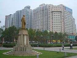
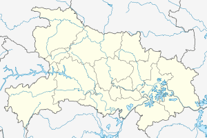
Wuchang forms part of the urban core of and is one of 13 districts of Wuhan, the capital of Hubei Province, China. It is the oldest of the three cities that merged into modern-day Wuhan, and stood on the right (southeastern) bank of the Yangtze River, opposite the mouth of the Han River. The two other cities, Hanyang and Hankou, were on the left (northwestern) bank, separated from each other by the Han.
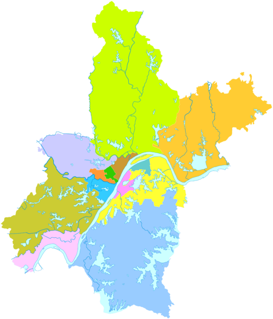
The name "Wuchang" remains in common use for the part of urban Wuhan south of the Yangtze River. Administratively, however, it is split between several districts of the City of Wuhan. The historic center of Wuchang lies within the modern Wuchang District, which has an area of 82.4 square kilometres (31.8 sq mi) and a population of 1,003,400.[4] Other parts of what is colloquially known as Wuchang are within Hongshan District (south and south-east) and Qingshan District (north-east). Presently, on the right bank of the Yangtze, it borders the districts of Qingshan (for a very small section) to the northeast and Hongshan to the east and south; on the opposite bank it borders Jiang'an, Jianghan and Hanyang.
On 10 October 1911, the New Army stationed in the city started the Wuchang Uprising, a turning point of the Xinhai Revolution that overthrew the Qing dynasty and established the Republic of China.
History
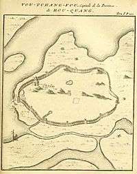
The old Wuchang county
In 221, warlord Sun Quan moved the capital of Eastern Wu from Gong'an county, Jingzhou (northwest of present-day Gong'an county, Hubei) to È county (in present-day Ezhou City), and renamed È to Wuchang (literally prospering from military, regarding its logistics role of the military bases established before the Battle of Red Cliffs). Later in the year Cao Pi proclaimed himself the emperor of Cao Wei. Sun Quan declared independence in the following year, and started to build forts and palaces in Wuchang. Sun Quan proclaimed himself the emperor of Eastern Wu in 229, and moved the capital to Jianye. Sun Hao, the emperor of Eastern Wu between 264 and 280, moved the capital back to Wuchang in 265. In 589, the Wuchang commandery was abolished and the Wuchang county was transferred to a new commandery named Ezhou (headquartered in present-day Wuchang District), and remained in the administration since then.
The present day Wuchang town
The Wuchang commandery was set up when È was renamed to Wuchang, and included six counties. In 223 the commandery was renamed to Jiangxia, and the capital of the commandery moved to Xiakou (in present-day Wuchang town). The name of the town was switched back and forth between Wuchang and Jiangxia several times in the following centuries. The present-day version of Wuying Pagoda, the oldest standing architecture in Hubei Province, was built around the time of fall of the Southern Song Dynasty. After 1301, the Wuchang prefecture, headquartered in the town, became the capital of Hubei province.
During the Taiping Rebellion, Wuchang and the surrounding area changed hands several times after the Taiping capture of the city in the Battle of Wuchang (1852).
At the end of the Qing Empire, the Wuchang Prefecture was the capital of the combined provinces of Hubei and Hunan, called the 'two Hu' or Huguang Viceroyalty. It was the seat of the provincial government of Huguang, at the head of which was a viceroy of Huguang. Next to Nanjing and Guangzhou, it was one of the most important vice-royalties in the empire.
It possessed an arsenal and a mint. The provincial government established ironworks for the manufacture of rails and other railway material. As the works did not pay under official management, they were transferred to the director-general of railways. Wuchang was not open to foreign trade and residence, but a considerable number of missionaries, both Roman Catholic and Protestant, lived within the walls. The native population was estimated at 800,000 around 1911, including cities on both banks. At that time, Wuchang was an important junction on the trunk railway from Beijing to Guangzhou; and was on the route of the Sichuan railway.
In Wuchang on October 10, 1911, a revolt broke out against the Qing Dynasty. This event, now called the Wuchang Uprising and celebrated as Double Ten Day, was the catalyst that started the Xinhai Revolution, which led to the development of the Republic of China.
In 1912, the Wuchang prefecture was abolished and a new Wuchang county (just next to the Wuchang county in the Ezhou city) was created. In 1926 the Wuchang town was promoted to a city, and merged with Hankou and Hanyang to form a new city named Wuhan.
After 1949, the more urban part of the Wuchang County was absorbed into the new Wuhan City and was administratively partitioned into Wuchang, Qingshan and Hongshan districts, while the remaining, mostly rural, southern part retained the name of Wuchang County. In 1995, Wuchang County became Jiangxia District of Wuhan.
Geography
Administrative divisions
.jpg)
Wuchang District administers:[5][6]
| # | Name | Chinese (S) | Pinyin Romanization | |||
|---|---|---|---|---|---|---|
| Subdistricts | ||||||
| 1 | Shidong Subdistrict Rock Cave | 石洞街道 | Shídòng Jiēdào | |||
| 2 | Yangyuan Subdistrict Yang Garden | 杨园街道 | Yángyuán Jiēdào | |||
| 3 | Xujiapeng Subdistrict | 徐家棚街道 | Xūjiāpéng Jiēdào | |||
| 4 | Jiyuqiao Subdistrict | 积玉桥街道 | Jīyùqiáo Jiēdào | |||
| 5 | Zhonghualu Subdistrict Zhonghua Road | 中华路街道 | Zhōnghuálù Jiēdào | |||
| 6 | Liangdao Subdistrict | 粮道街道 | Liángdào Jiēdào | |||
| 7 | Huanghelou Subdistrict Yellow Crane Tower | 黄鹤楼街道 | Huánghèlóu Jiēdào | |||
| 8 | Ziyang Subdistrict | 紫阳街道 | Zǐyáng Jiēdào | |||
| 9 | Baishazhou Subdistrict White Sand Islet | 白沙洲街道 | Báishāzhōu Jiēdào | |||
| 10 | Shouyilu Subdistrict First to Rise in Revolt Road | 首义路街道 | Shǒuyìlù Jiēdào | |||
| 11 | Zhongnanlu Subdistrict South Central Road | 中南路街道 | Zhōngnánlù Jiēdào | |||
| 12 | Shuiguohu Subdistrict Fruit Lake | 水果湖街道 | Shuǐguǒhú Jiēdào | |||
| 13 | Luojiashan Subdistrict Mount Luojia | 珞珈山街道 | Luòjiāshān Jiēdào | |||
| 14 | Nanhu Subdistrict South Lake | 南湖街道 | Nánhú Jiēdào | |||
| 15 | Donghu Scenic Area East Lake | 东湖风景区 | Dōnghú Fēngjǐngqū | |||
See also
The Wuchang fish (Megalobrama amblycephala; 武昌鱼; 武昌魚; Wǔchāng yú) is named after the town.
References
- ↑ Google (2014-07-02). "Wuchang" (Map). Google Maps. Google. Retrieved 2014-07-02.
- ↑ "Wuhan Statistical Yearbook 2010" (PDF). Wuhan Statistics Bureau. p. 15. Retrieved 2011-07-30.
- ↑ "武汉市2010年第六次全国人口普查主要数据公报". Wuhan Statistics Bureau. 2011-05-11. Archived from the original on 2011-10-25. Retrieved 2011-06-11.
- ↑ "Profile of Wuchang District" (in Chinese). official website of Wuchang District Government. Archived from the original on 2008-03-24. Retrieved 2008-04-19.
- ↑ 武汉市武昌区区属部门预决算及“三公”经费预决算信息 (in Simplified Chinese). Wuchang District People's Government. Retrieved 27 December 2017.
石洞街 杨园街 徐家棚街 积玉桥街 中华路街 粮道街 黄鹤楼街 紫阳街 白沙洲街 首义路街 中南路街 水果湖街 珞珈山街 南湖街
- ↑ 武昌区历史沿革 [Historical Development of Wuchang District] (in Simplified Chinese).
行政区划网站 (XZQH). 7 July 2014. Retrieved 27 December 2017.
2010年第六次人口普查,武昌区常住总人口1214287人,其中:积玉桥街道60323人,杨园街道109485人,徐家棚街道123918人,粮道街道64704人,中华路街道44262人,黄鹤楼街道60909人,紫阳街道61135人,白沙洲街道76226人,首义路街道69562人,中南路街道216216人,水果湖街道178628人,珞珈山街道75128人,石洞街道6664人,南湖街道52596人,东湖风景区街道(武昌)14531人。
templatestyles stripmarker in|publisher=at position 1 (help)
External links
| Wikimedia Commons has media related to Wuchang District. |