Changzhi
| Changzhi 长治市 | |
|---|---|
| Prefecture-level city | |
 | |
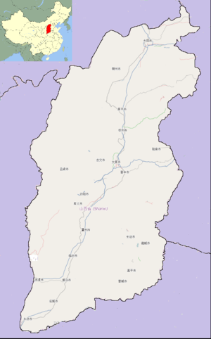
.png) Location of Changzhi City jurisdiction in Shanxi | |
 Changzhi Location of the city center in Shanxi | |
| Coordinates: 36°11′N 113°06′E / 36.183°N 113.100°ECoordinates: 36°11′N 113°06′E / 36.183°N 113.100°E | |
| Country | People's Republic of China |
| Province | Shanxi |
| County-level divisions | 13 |
| Incorporated (city) | 1945.10 |
| Municipal seat | Chengqu (Urban District) |
| Government | |
| • Type | Prefecture-level city |
| • Communist Party Committee Secretary of Changzhi City | Ma, Tianrong (马天荣) |
| • Mayor | Xi, Xiaojun (席小军) |
| Area | |
| • Total | 13,864 km2 (5,353 sq mi) |
| Population (2005) | |
| • Total | 3,234,100 |
| • Density | 230/km2 (600/sq mi) |
| Time zone | UTC+8 (China Standard) |
| Postal code | 046000 |
| Area code(s) | 0355 |
| ISO 3166 code | CN-SX-04 |
| Licence Plate Prefix | 晋D |
| Administrative division code | 140400 |
| Website | Official website |
Changzhi (simplified Chinese: 长治; traditional Chinese: 長治; pinyin: Chángzhì; literally: "long rule") is a prefecture-level city in the southeast of Shanxi Province, China, bordering the provinces of Hebei and Henan to the northeast and east, respectively. Historically, the city was one of the 36 administrative areas (see Administrative Divisions of Qin Dynasty) extant under the reign of the first emperor of a unified China (see Qin Shi Huang).
Nowadays, Changzhi is a transportation centre in Shanxi. Transportations is facilitated by: four controlled-access highways, (Taiyuan-Changzhi, Changzhi-Jincheng, Changzhi-Linfen, and Changzhi-Handan); two railways, (Taiyuan–Jiaozuo Railway and Handan–Changzhi Railway ); three national highways, China National Highway 207, 208 and 309; and Changzhi Wangcun Airport (ITAT Code: CIH, ICAO Code: ZBCZ). Internal transportation also includes a bus and taxi network.
The city is a rising commercial and industrial centre in the southeastern area of Shanxi. In 2011, its GDP ranked 1st out of 11 prefecture-level cities in the province.[1] According to the 6th National Population Census, in 2010 the city was home to 3,334,564 residents.[2]
The local environment, especially the Air Quality Index, is monitored by China's Ministry of Environmental Protection (MEP)[3] and city government. A record of daily air quality is published by the local government.[4]
History
In ancient times the area around Changzhi (Including Jincheng) was known as Shangdang.[5] Changzhi was the site of the Shangdang Campaign, the first battle between the Kuomintang and the People's Liberation Army after the end of World War II. The campaign began in August 1945 and lasted until October. It began when the local Shanxi warlord, Yan Xishan, attempted to retake the region from Communist forces. Yan's forces were eventually defeated by an army led by Liu Bocheng, who was later named one of China's Ten Great Marshals. Liu's political commissar was Deng Xiaoping, who later became China's "paramount leader". The campaign ended with the complete destruction of Yan's army, most of which joined the Communists after surrendering. Following the Shangdang Campaign, the Communists remained in control of the region until they won the civil war in 1949.[5]
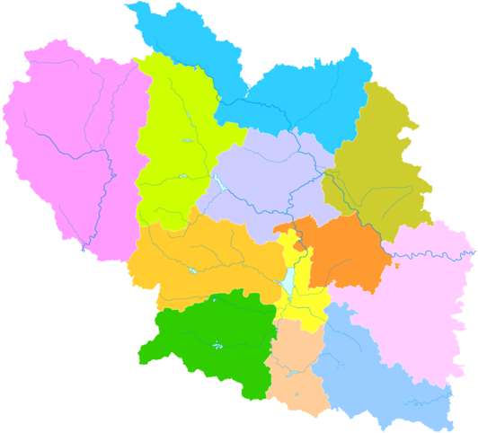
Administrative divisions
The area under the control of People's Government of Changzhi City is divided into 13 local government districts. They are 4 districts Luzhou, Lucheng, Shangdang, and Tunliu; and 8 counties Xiangyuan County, Pingshun County, Licheng County, Huguan County, Zhangzi County, Wuxiang County, Qin County, and Qinyuan County.
| Map | |||||||
|---|---|---|---|---|---|---|---|
| Name | Hanzi | Hanyu Pinyin | Population (2003 est.) | Area (km²) | Density (/km²) | ||
| Luzhou District | 潞州区 | Lùzhōu Qū | 706,000 | 340.6 | 2072.8 | ||
| Lucheng District | 潞城区 | Lùchéng Qū | 210,000 | 615 | 341 | ||
| Shangdang District | 上党区 | Shàngdǎng Qū | 320,000 | 483 | 663 | ||
| Tunliu District | 屯留区 | Túnliú Qū | 240,000 | 1,042 | 230 | ||
| Xiangyuan County | 襄垣县 | Xiāngyuán Xiàn | 250,000 | 1,158 | 216 | ||
| Pingshun County | 平顺县 | Píngshùn Xiàn | 160,000 | 1,550 | 103 | ||
| Licheng County | 黎城县 | Líchéng Xiàn | 160,000 | 1,166 | 137 | ||
| Huguan County | 壶关县 | Húguān Xiàn | 280,000 | 1,013 | 276 | ||
| Zhangzi County | 长子县 | Zhǎngzǐ Xiàn | 340,000 | 1,029 | 330 | ||
| Wuxiang County | 武乡县 | Wǔxiāng Xiàn | 210,000 | 1,610 | 130 | ||
| Qin County | 沁县 | Qìn Xiàn | 170,000 | 1,297 | 131 | ||
| Qinyuan County | 沁源县 | Qìnyuán Xiàn | 150,000 | 2,556 | 59 | ||
- Defunct - Cheng District (Chinese: 城区; pinyin: Chéngqū) is largely made up of city center of the metropolitan area.
Education
Higher Education
Changzhi Medical College
Changzhi College
High Schools
Changzhi No.1 Middle School
Changzhi No.2 Middle School
Changzhi No.3 Middle School
Changzhi No.4 Middle School
Changzhi No.5 Middle School
Changzhi No.6 Middle School
Changzhi No.7 Middle School
Changzhi No.8 Middle School
Changzhi No.9 Middle School
Changzhi No.10 Middle School
Changzhi Experimental Middle School
Changzhi No.12 Middle School
Changzhi No.13 Middle School
Changzhi No.14 Middle School
Changzhi No.15 Middle School
Changzhi No.16 Middle School
Changzhi No.17 Middle School
Changzhi No.18 Middle School
Changzhi No.19 Middle School
Tai-Hang Middle School (Subsidiary Middle School of Changzhi College)
Transportation
National Highway
Controlled-access Highway
- Controlled-access Highway Taiyuan-Changzhi
- Controlled-access Highway Changzhi-Jincheng
- Controlled-access Highway Changzhi-Linfen
- Controlled-access Highway Changzhi-Handan
Railway
Airport
External links
Notes and references
- ↑ Statistics Report of Changzhi Economy in 2011 (In Chinese)
- ↑ Population Data of Changzhi in Shanxi Province (the 6th National Population Census) in Chinese Archived February 24, 2013, at the Wayback Machine.
- ↑ Air Quality Database of Key Cities in China, in Chinese
- ↑ Changzhi City Environmental Protection Archived 2013-12-30 at the Wayback Machine.
- 1 2 Lew, Christopher R. The Third Chinese Revolutionary War, 1945-1949: An Analysis of Communist Strategy and Leadership. The USA and Canada: Routelage. 2009, p.22–23. ISBN 0-415-77730-5