Qahar Right Rear Banner
| Qahar Right Rear Banner 察哈尔右翼后旗 • ᠴᠠᠬᠠᠷᠪᠠᠷᠠᠭᠤᠨᠭᠠᠷᠤᠨᠬᠣᠶᠢᠲᠤᠬᠣᠰᠢᠭᠤ | |
|---|---|
| Banner | |
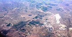 Aerial view over central parts of the county, with agriculture and Guangmingcun open-pit mine. | |
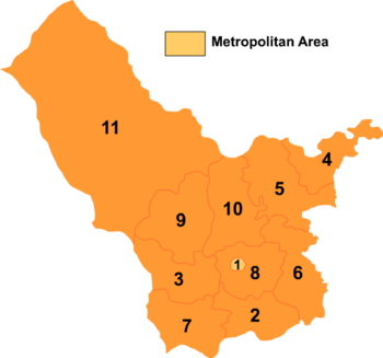 Ulanqab's divisions: Chahar Right Rear Banner is 10 on this map | |
 Chahar YYHQ Location in Inner Mongolia | |
| Coordinates: 41°26′N 113°11′E / 41.433°N 113.183°ECoordinates: 41°26′N 113°11′E / 41.433°N 113.183°E | |
| Country | People's Republic of China |
| Region | Inner Mongolia |
| Prefecture-level city | Ulaan Chab |
| Administrative Centre | Baiyinchagan Town |
| Elevation | 1,440 m (4,720 ft) |
| Time zone | UTC+8 (China Standard) |
Chahar Right Rear Banner (Mongolian: ᠴᠠᠬᠠᠷ ᠪᠠᠷᠠᠭᠤᠨ ᠭᠠᠷᠤᠨ ᠬᠣᠶᠢᠲᠤ ᠬᠣᠰᠢᠭᠤ; Цахар баруун гарын хойд хошуу; Čaqar Baraɣun Ɣarun Qoyitu qosiɣu; simplified Chinese: 察哈尔右翼后旗; traditional Chinese: 察哈爾右翼後旗; pinyin: Cháhā'ěr Yòuyì Hòuqí) is a banner of Inner Mongolia, People's Republic of China, bordering Shangdu County to the northeast, Xinghe County to the southeast, Chahar Right Front Banner to the south, Zhuozi County to the southwest, Chahar Right Rear Banner to the west, Siziwang Banner to the northwest, and Xilin Gol to the north. It is under the administration of Ulaan Chab City, which lies to the south along the G55 Erenhot–Guangzhou Expressway. The most important settlement in the banner is Baiyinchagan.
References
- www.xzqh.org (in Chinese)
| Wikimedia Commons has media related to Chahar Right Rear Banner. |
This article is issued from
Wikipedia.
The text is licensed under Creative Commons - Attribution - Sharealike.
Additional terms may apply for the media files.