Dunhuang
| Dunhuang 敦煌市 | |
|---|---|
| County-level city | |
 Dunhuang | |
.png) Dunhuang City (red) in Jiuquan City (yellow) and Gansu | |
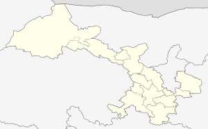 Dunhuang Location in Gansu | |
| Coordinates: 40°09′N 94°40′E / 40.150°N 94.667°ECoordinates: 40°09′N 94°40′E / 40.150°N 94.667°E | |
| Country | People's Republic of China |
| Province | Gansu |
| Prefecture-level city | Jiuquan |
| Area[1] | |
| • Total | 32,000 km2 (12,000 sq mi) |
| Elevation | 1,142 m (3,747 ft) |
| Population (2010)[1] | |
| • Total | 186,027 |
| • Density | 5.8/km2 (15/sq mi) |
| Time zone | UTC+8 (CST) |
| Website |
www |
| Dunhuang | |||||||||||||||||
|
"Dunhuang" in Chinese characters | |||||||||||||||||
| Chinese | 敦煌 | ||||||||||||||||
|---|---|---|---|---|---|---|---|---|---|---|---|---|---|---|---|---|---|
| Postal | Tunhwang | ||||||||||||||||
| Literal meaning | "Blazing Beacon" | ||||||||||||||||
| |||||||||||||||||
Dunhuang (![]()
Dunhuang is situated in a oasis containing Crescent Lake and Mingsha Shan (鸣沙山, meaning "Singing-Sand Mountain"), named after the sound of the wind whipping off the dunes, the singing sand phenomenon. Dunhuang commands a strategic position at the crossroads of the ancient Southern Silk Route and the main road leading from India via Lhasa to Mongolia and Southern Siberia,[2] as well as controlling the entrance to the narrow Hexi Corridor, which led straight to the heart of the north Chinese plains and the ancient capitals of Chang'an (today known as Xi'an) and Luoyang.[4]
Administratively, the county-level city of Dunhuang is part of the prefecture-level city of Jiuquan.
History
There is evidence of habitation in the area as early as 2,000 BC, possibly by people recorded as the Qiang in Chinese history. Its name was also mentioned in relation to the homeland of the Yuezhi in the Records of the Grand Historian. Some have argued that this may refer to the unrelated toponym Dunhong – the archaeologist Lin Meicun has also suggested that Dunhuan may be a Chinese name for the Tukhara, a people widely believed to be a Central Asian offshoot of the Yuezhi.[5]
By the third century BC, the area became dominated by the Xiongnu, but came under Chinese rule during the Han Dynasty after Emperor Wu defeated the Xiongnu in 121 BC.
Dunhuang was one of the four frontier garrison towns (along with Jiuquan, Zhangye and Wuwei) established by the Emperor Wu after the defeat of the Xiongnu, and the Chinese built fortifications at Dunhuang and sent settlers there. The name Dunhuang, meaning "Blazing Beacon", refers to the beacons lit to warn of attacks by marauding nomadic tribes. Dunhuang Commandery was probably established shortly after 104 BC.[6] Located in the western end of the Hexi Corridor near the historic junction of the Northern and Southern Silk Roads, Dunhuang was a town of military importance.[7]
"The Great Wall was extended to Dunhuang, and a line of fortified beacon towers stretched westwards into the desert. By the second century AD Dunhuang had a population of more than 76,000 and was a key supply base for caravans that passed through the city: those setting out for the arduous trek across the desert loaded up with water and food supplies, and others arriving from the west gratefully looked upon the mirage-like sight of Dunhuang's walls, which signified safety and comfort. Dunhuang prospered on the heavy flow of traffic. The first Buddhist caves in the Dunhuang area were hewn in 353."[8]
During the Sui (581-618) and Tang (618-907) dynasties, it was the main stop of communication between ancient China and the rest of the world and a major hub of commerce of the Silk Road. Dunhuang was the intersection city of all three main silk routes(north, central, south) during this time.
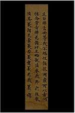
From the West also came early Buddhist monks who had arrived in China by the first century AD, and a sizable Buddhist community eventually developed in Dunhuang. The caves carved out by the monks, originally used for meditation, developed into a place of worship and pilgrimage called the Mogao Caves or "Caves of a Thousand Buddhas."[9] A number of Christian, Jewish, and Manichaean artifacts have also been found in the caves (see for example Jesus Sutras), testimony to the wide variety of people who made their way along the Silk Road.
During the time of the Sixteen Kingdoms, Li Gao established the Western Liang here in 400 AD. In 405 the capital of the Western Liang was moved from Dunhuang to Jiuquan. In 421 the Western Liang was conquered by the Northern Liang.
As a frontier town, Dunhuang was fought over and occupied at various times by non-Han people. After the fall of Han Dynasty it came under the rule of various nomadic tribes, such as the Xiongnu during Northern Liang and the Turkic Tuoba during Northern Wei. The Tibetans occupied Dunhuang when the Tang empire became weakened considerably after the An Lushan Rebellion; and even though it was later returned to Tang rule, it was under quasi-autonomous rule by the local general Zhang Yichao who expelled the Tibetans in 848. After the fall of Tang, Zhang's family formed the Kingdom of Golden Mountain in 910,[10] but in 911 it came under the influence of the Uighurs. The Zhangs were succeeded by the Cao family who formed alliances with the Uighurs and the Kingdom of Khotan. During the Song Dynasty, Dunhuang fell outside the Chinese borders. In 1036 the Tanguts who founded the Xi Xia Dynasty captured Dunhuang.[10] From the reconquest of 848 to about 1036 (i.e. era of the Guiyi Circuit), Dunhuang was a multicultural entrepot that contained one of the largest ethnic Sogdian communities in China following the An Lushan Rebellion. The Sogdians were Sinified to some extent and were bilingual in Chinese and Sogdian, and wrote their documents in Chinese characters but written horizontally from left to right instead of the right to left vertical lines that Chinese was normally written at the time.[11]
Dunhuang was conquered in 1227 by the Mongols who sacked and destroyed the town, and the rebuilt town became part of the Mongol Empire in the wake of Kublai Khan' s conquest of China under the Yuan Dynasty. Dunhuang went into a steep decline after the Chinese trade with the outside world became dominated by Southern sea-routes, and the Silk Road was officially abandoned during the Ming Dynasty. It was occupied again by the Tibetans c. 1516, and also came under the influence of the Chagatai Khanate in the early sixteenth century.[12] It was retaken by China two centuries later c. 1715 during the Qing Dynasty, and the present-day city of Dunhuang was established east of the ruined old city in 1725.[13] In 1988, Dunhuang was elevated from county to county-level city status.[1]
Today, the site is an important tourist attraction and the subject of an ongoing archaeological project. A large number of manuscripts and artifacts retrieved at Dunhuang have been digitized and made publicly available via the International Dunhuang Project.[14] The expansion of the Kumtag Desert, which is resulting from long-standing overgrazing of surrounding lands, has reached the edges of the city.[15]
In 2011 satellite images showing huge structures in the desert near Dunhuang surfaced online and caused a brief media stir.[16]
Culture
Buddhist caves
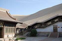
A number of Buddhist cave sites are located in the Dunhuang area, the most important of these is the Mogao Caves which is located 25 km (16 mi) southeast of Dunhuang. There are 735 caves in Mogao, and the caves in Mogao are particularly noted for their Buddhist art,[17] as well as the hoard of manuscripts, the Dunhuang manuscripts, found hidden in a sealed-up cave. Many of these caves were covered with murals and contain many Buddhist statues. Discoveries continue to be found in the caves, including excerpts from a Christian Bible dating to the Yuan Dynasty.[18]
Numerous smaller Buddhist cave sites are located in the region, including the Western Thousand Buddha Caves, the Eastern Thousands Buddha Caves, and the Five Temple site. The Yulin Caves are located further east in Guazhou County.
Other historical sites
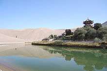
- Crescent Lake
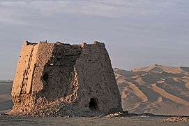
- The Yumen Pass, built in 111 BC, located 90 km (56 mi) northwest of Dunhuang in the Gobi desert.
- The Yangguan Pass
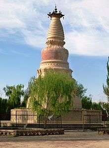
- White Horse Pagoda
- Dunhuang Limes
Museums

Night market
Dunhuang Night Market is a night market held on the main thoroughfare, Dong Dajie, in the city centre of Dunhuang, popular with tourists during the summer months. Many souvenir items are sold, including such typical items as jade, jewelry, scrolls, hangings, small sculptures, leather shows puppets, coins, Tibetan horns and Buddha statues.[20] A sizable number of members of China's ethnic minorities engage in business at these markets. A Central Asian dessert or sweet is also sold, consisting of a large, sweet confection made with nuts and dried fruit, sliced into the portion desired by the customer.
Geography
Administrative divisions
Since 2015, Dunhuang has been divided into nine towns and two other areas:[1][21][22]
Nine towns:
- Qili (七里镇), Shazhou (沙州镇), Suzhou (肃州镇), Mogao (莫高镇), Zhuanqukou (转渠口镇), Yangguan (阳关镇), Yueyaquan (月牙泉镇), Guojiabao/bu/pu (郭家堡镇), Huangqu (黄渠镇)
Two other areas:
- Guoying Dunhuang Farm (国营敦煌农场), Qinghai Oil Management Office Life Base (青海石油管理局生活基地)
Climate
Dunhuang has a cold desert climate (Köppen BWk), with an annual total precipitation of 67 millimetres (2.64 in), the majority of which occurs in summer; precipitation occurs only in trace amounts and quickly evaporates.[23] Winters are long and cold, with a 24-hour average temperature of −8.3 °C (17.1 °F) in January, while summers are hot, with a July average of 24.6 °C (76.3 °F); the annual mean is 9.48 °C (49.1 °F). The diurnal temperature variation averages 16.1 °C (29.0 °F) annually. With monthly percent possible sunshine ranging from 69% in March to 82% in October, the city receives 3,258 hours of bright sunshine annually, making it one of the sunniest nationwide.
| Climate data for Dunhuang (1971−2000) | |||||||||||||
|---|---|---|---|---|---|---|---|---|---|---|---|---|---|
| Month | Jan | Feb | Mar | Apr | May | Jun | Jul | Aug | Sep | Oct | Nov | Dec | Year |
| Average high °C (°F) | −0.8 (30.6) |
4.9 (40.8) |
12.7 (54.9) |
21.2 (70.2) |
27.0 (80.6) |
30.9 (87.6) |
32.7 (90.9) |
31.7 (89.1) |
26.8 (80.2) |
18.8 (65.8) |
8.4 (47.1) |
0.6 (33.1) |
17.9 (64.2) |
| Average low °C (°F) | −14.6 (5.7) |
−10.5 (13.1) |
−3.2 (26.2) |
4.1 (39.4) |
9.6 (49.3) |
13.9 (57) |
16.4 (61.5) |
14.6 (58.3) |
8.5 (47.3) |
0.6 (33.1) |
−5.5 (22.1) |
−12 (10) |
1.8 (35.3) |
| Average precipitation mm (inches) | 0.8 (0.031) |
0.8 (0.031) |
2.1 (0.083) |
2.4 (0.094) |
2.4 (0.094) |
8.0 (0.315) |
15.2 (0.598) |
6.3 (0.248) |
1.5 (0.059) |
0.8 (0.031) |
1.3 (0.051) |
0.8 (0.031) |
42.4 (1.666) |
| Average precipitation days (≥ 0.1 mm) | 1.5 | 0.9 | 1.2 | 1.3 | 1.3 | 3.7 | 4.8 | 2.6 | 0.9 | 0.5 | 1.1 | 1.3 | 21.1 |
| Average relative humidity (%) | 52 | 40 | 35 | 31 | 33 | 42 | 45 | 45 | 45 | 45 | 51 | 55 | 43 |
| Mean monthly sunshine hours | 219.0 | 218.6 | 254.9 | 282.4 | 320.2 | 313.6 | 318.9 | 316.1 | 296.1 | 280.8 | 230.4 | 206.8 | 3,257.8 |
| Percent possible sunshine | 74 | 73 | 69 | 71 | 72 | 70 | 70 | 75 | 79 | 82 | 77 | 72 | 74 |
| Source: China Meteorological Administration | |||||||||||||
Transportation
Dunhuang is served by China National Highway 215 and Dunhuang Airport,
A railway branch known as the Dunhuang Railway (敦煌铁路) or the Liudun Railway (柳敦铁路), constructed in 2004-2006, connects Dunhuang with the Liugou Station on the Lanzhou-Xinjiang Railway (in Guazhou County). There is regular passenger service on the line, with overnight trains from Dunhuang to Lanzhou and Xi'an.[24] Dunhuang Station is located northeast of town, near the airport.
There are plans to extend the railway from Dunhuang further south into Qinghai, connecting Dunhuang to Yinmaxia (near Golmud) on the Qingzang Railway. Construction work on this Golmud–Dunhuang Railway started in October 2012, and is expected to be completed in 5 years.[25]
See also
Gallery
.jpg) The Singing Sand Dunes on the eastern edge of the Kumtag Desert near Dunhuang.
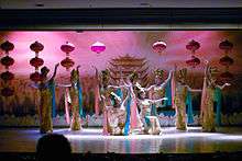
The Singing Sand Dunes on the eastern edge of the Kumtag Desert near Dunhuang.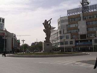 Sculpture in Dunhuang, after a mural in Mogao Caves, depicting an Apsara playing the pipa behind her back (Chinese: 反弹琵琶伎乐天).
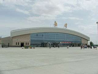
.jpg) Mogao Caves, a.k.a. Dunhuang Grottoes.
Mogao Caves, a.k.a. Dunhuang Grottoes.
Footnotes
- 1 2 3 4 "敦煌市历史沿革" [Dunhuang City Historical Development]. 行政区划网站 www.xzqh.org (in Simplified Chinese). 行政区划网站/区划地名网站 (Administrative Divisions Web/District Geographic Names Web). 27 June 2016. Retrieved 27 May 2018.
汉置敦煌县{...}清又改称敦煌县。{...}1988年设市。{...}1996年,敦煌市面积3.2万平方千米{...}2010年第六次人口普查,敦煌市常住总人口186027人{...}2011年初,撤销杨家桥乡,设立月牙泉镇(2010年末省民政厅批复)。调整后,全市辖7个镇、2个乡:七里镇、沙州镇、肃州镇、莫高镇、转渠口镇乡、阳关镇、月牙泉镇、郭家堡乡、黄渠乡。市政府驻沙洲镇。 2015年,省民政厅(甘民复〔2015〕50号)批复同意撤销郭家堡乡、黄渠乡,设立郭家堡镇、黄渠镇。
- 1 2 Cable and French (1943), p. 41.
- ↑ Skrine (1926), p. 117.
- ↑ Lovell (2006), pp. 74-75.
- ↑ Lin Meicun (1998 ), The Western Regions of the Han–Tang Dynasties and the Chinese Civilization [Chinese language only], Beijing, Wenwu Chubanshe, pp. 64–67.
- ↑ Hulsewé, A. F. P. (1979). China in Central Asia: The Early Stage 125 BC – AD 23: an annotated translation of chapters 61 and 96 of the History of the Former Han Dynasty. Leiden, E. Brill, . pp.75-76 ISBN 90-04-05884-2
- ↑ Hill (2015), Vol. I, pp. 137-140.
- ↑ Bonavia (2004), p. 162.
- ↑ The Silk Road: Two Thousand Years in the Heart of Asia, by Frances Wood
- 1 2 "Dunhuang Studies - Chronology and History". Silkroad Foundation.
- ↑ Galambos, Imre (2015), "She Association Circulars from Dunhuang", in Antje Richter, A History of Chinese Letters and Epistolary Culture, Brill: Leiden, Boston, pp 853-77.
- ↑ Tim Pepper (1996). Trudy Ring, Noelle Watson, Paul Schellinger, eds. Asia and Oceania: International Dictionary of Historic Places. Routledge. pp. 239–241. ISBN 978-1884964046.
- ↑ Whitfield, Roderick, Susan Whitfield, and Neville Agnew. (2000). Cave Temples of Dunhuang: Art and History on the Silk Road. The British Library. ISBN 0-7123-4697-X.
- ↑ "The International Dunhuang Project". International Dunhuang Project. Retrieved 29 July 2011.
- ↑ "Ancient Chinese town on front lines of desertification battle, AFP, Nov 20, 2007".
- ↑ Wolchover, Natalie (16 November 2011). "Odd patterns in Chinese desert? Spy satellite targets.". MSNBC. Archived from the original on 19 November 2011.
- ↑ Dunhuang Mogao caves art museum
- ↑ Syrian Language "Holy Bible" Discovered in Dunhuang Grottoes
- ↑ Wang Xudang, Li Zuixiong, and Zhang Lu (2010). "Condition, Conservation, and Reinforcement of the Yumen Pass and Hecang Earthen Ruins Near Dunhuang", in Neville Agnew (ed), Conservation of Ancient Sites on the Silk Road: Proceedings of the Second International Conference on the Conservation of Grotto Sites, Mogao Grottoes, Dunhuang, People's Republic of China, June 28 - July 3, 2004, 351-357. Los Angeles: The Getty Conservation Institute, J. Paul Getty Trust. ISBN 978-1-60606-013-1, pp 351-352.
- ↑ China. Eye Witness Travel Guides. p. 494.
- ↑ "2016年统计用区划代码和城乡划分代码:敦煌市" [2016 Statistical Area Numbers and Rural-Urban Area Numbers: Duhuang City]. 中华人民共和国国家统计局信息网 (in Simplified Chinese). 中华人民共和国国家统计局 National Bureau of Statistics of the People's Republic of China. 2016. Retrieved 27 May 2018.
统计用区划代码 名称 620982100000 七里镇 620982101000 沙州镇 620982102000 肃州镇 620982103000 莫高镇 620982104000 转渠口镇 620982105000 阳关镇 620982106000 月牙泉镇 620982107000 郭家堡镇 620982108000 黄渠镇 620982400000 国营敦煌农场 620982401000 青海石油管理局生活基地
- ↑ "行政区划" [Administrative Divisions]. 敦煌市人民政府门户网站 (in Simplified Chinese). 敦煌市人民政府办公室. 4 January 2017. Retrieved 27 May 2018.
敦煌市辖9镇,56个村民委员会。沙州镇为市委、市政府所在地,{...}城西7公里处的七里镇是一座新型的石油城,现为青海石油管理局机关所在地和青海油田后勤生活基地。
- ↑ "Dunhuang Climate − Best time to visit". Retrieved 2009-12-06.
- ↑ Dunhuang Train Schedule (in Chinese)
- ↑ 格尔木至敦煌铁路开工, Renmin Tielu Bao, 2012-10-20
References
- Baumer, Christoph. 2000. Southern Silk Road: In the Footsteps of Sir Aurel Stein and Sven Hedin. White Orchid Books. Bangkok.
- Beal, Samuel. 1884. Si-Yu-Ki: Buddhist Records of the Western World, by Hiuen Tsiang. 2 vols. Trans. by Samuel Beal. London. Reprint: Delhi. Oriental Books Reprint Corporation. 1969.
- Beal, Samuel. 1911. The Life of Hiuen-Tsiang by the Shaman Hwui Li, with an Introduction containing an account of the Works of I-Tsing. Trans. by Samuel Beal. London. 1911. Reprint: Munshiram Manoharlal, New Delhi. 1973.
- Bonavia, Judy (2004): The Silk Road From Xi'an to Kashgar. Judy Bonavia – revised by Christoph Baumer. 2004. Odyssey Publications.
- Cable, Mildred and Francesca French (1943): The Gobi Desert. London. Landsborough Publications.
- Galambos, Imre (2015), "She Association Circulars from Dunhuang", in Antje Richter, A History of Chinese Letters and Epistolary Culture, Brill: Leiden, Boston, pp 853–77.
- Hill, John E. 2004. The Peoples of the West from the Weilue 魏略 by Yu Huan 魚豢: A Third Century Chinese Account Composed between 239 and 265 CE. Draft annotated English translation.
- Hulsewé, A. F. P. and Loewe, M. A. N. 1979. China in Central Asia: The Early Stage 125 BC – AD 23: an annotated translation of chapters 61 and 96 of the History of the Former Han Dynasty. E. J. Brill, Leiden.
- Legge, James. Trans. and ed. 1886. A Record of Buddhistic Kingdoms: being an account by the Chinese monk Fâ-hsien of his travels in India and Ceylon (AD 399-414) in search of the Buddhist Books of Discipline. Reprint: Dover Publications, New York. 1965.
- Lok, Wai-ying. (2012). The significance of Dunhuang iconography from the perspective of Buddhist philosophy: a study mainly based on Cave 45 (PDF) (PhD Dissertation). The University of Hong Kong.
- Lovell, Julia (2006). The Great Wall : China against the World. 1000 BC — AD 2000. Atlantic Books, London. ISBN 978-1-84354-215-5.
- Skrine, C. P. (1926). Chinese Central Asia. Methuen, London. Reprint: Barnes & Noble, New York. 1971. ISBN 0-416-60750-0.
- Stein, Aurel M. 1907. Ancient Khotan: Detailed report of archaeological explorations in Chinese Turkestan, 2 vols. Clarendon Press. Oxford.
- Stein, Aurel M. 1921. Serindia: Detailed report of explorations in Central Asia and westernmost China, 5 vols. London & Oxford. Clarendon Press. Reprint: Delhi. Motilal Banarsidass. 1980.
- Watson, Burton (1993). Records of the Grand Historian of China. Han Dynasty II. (Revised Edition). New York, Columbia University Press. ISBN 0-231-08167-7
- Watters, Thomas (1904–1905). On Yuan Chwang's Travels in India. London. Royal Asiatic Society. Reprint: 1973.
External links
| Wikimedia Commons has media related to Dunhuang. |
| Wikivoyage has a travel guide for Dunhuang. |
- The International Dunhuang Project - includes tens of thousands of digitised manuscripts and paintings from Dunhuang, along with historical photographs and archival material
- British Museum: A Christian figure, ink and colours on a fragment of silk from Dunhuang
- Dunhuang Collection at the British Museum
- Dunhuang at the British Museum (accessed 30 Jan 2018)
- Qianfodong at the British Museum (accessed 30 Jan 2018)
- Dunhuang Collection at the National Museum of India
- "Dunhuang". Silk Road Seattle. USA: Walter Chapin Simpson Center for the Humanities, University of Washington.