Ulanqab
| Ulanqab 乌兰察布市 • ᠤᠯᠠᠭᠠᠨᠴᠠᠪ ᠬᠣᠲᠠ | |
|---|---|
| Prefecture-level city | |
 Huanghuagou, a grassland scenic spot near Ulanqab | |
.svg.png) Location of Ulanqab City jurisdiction in Inner Mongolia | |
 Ulanqab Location of the city centre in Inner Mongolia | |
| Coordinates: 41°00′N 113°08′E / 41.000°N 113.133°ECoordinates: 41°00′N 113°08′E / 41.000°N 113.133°E | |
| Country | People's Republic of China |
| Region | Inner Mongolia |
| Municipal seat | Jining District |
| Area | |
| • Total | 54,491 km2 (21,039 sq mi) |
| Elevation | 1,378 m (4,521 ft) |
| Population (2010) | |
| • Total | 2,143,590 |
| • Density | 39/km2 (100/sq mi) |
| Time zone | UTC+8 (China Standard) |
| Postal code | 012000 |
| Area code(s) | (0)474 |
| ISO 3166 code | CN-NM-09 |
| Licence Plate Prefix | 蒙J |
| Website |
wulanchabu |
| Ulanqab | |||||||
| Chinese name | |||||||
|---|---|---|---|---|---|---|---|
| Simplified Chinese | 乌兰察布 | ||||||
| Traditional Chinese | 烏蘭察布 | ||||||
| |||||||
| Mongolian name | |||||||
| Mongolian Cyrillic | Улаанцав хот | ||||||
| Mongolian script | ᠤᠯᠠᠭᠠᠨᠴᠠᠪ ᠬᠣᠲᠠ | ||||||
| |||||||
Ulanqab or Ulan Chab (Mongolian: ᠤᠯᠠᠭᠠᠨᠴᠠᠪ ᠬᠣᠲᠠ, Ulaɣančab qota; Улаанцав хот, Ulāncaw hot; Chinese: 乌兰察布; pinyin: Wūlánchábù) is a region administered as a prefecture-level city in south-central Inner Mongolia, People's Republic of China. Its administrative centre is in Jining District, which was formerly a county-level city. It was established as a prefecture-level city on 1 December 2003, formed from the former Ulanqab League.
Ulaan Chab city has an area of 54,491 square kilometres (21,039 sq mi). It borders Hohhot to the west, Mongolia to the north, Xilin Gol League to the northeast, Hebei to the east and Shanxi to the south. At the end of 2004, Ulanqab had 2.7 million inhabitants.
The western part of Ulaan Chab used to be part of the now defunct Chinese province of Suiyuan.
Administrative subdivisions
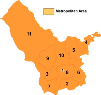
Ulaan Chab has eleven administrative divisions: one district, one county-level city, five counties and four banners:
| Map | |||||||
|---|---|---|---|---|---|---|---|
 | |||||||
| # | Name | Mongolian | Hanzi | Hanyu Pinyin | Population (2010 est.) |
Area (km²) | Density (/km²) |
| 1 | Jining District | ᠵᠢᠨᠢᠩ ᠲᠣᠭᠣᠷᠢᠭ (Jiniŋ toɣoriɣ) |
集宁区 | Jíníng Qū | 356,135 | 418 | 851 |
| 2 | Fengzhen City | ᠹᠧᠩᠵᠧᠨ ᠬᠣᠲᠠ (Fėŋjėn qota) |
丰镇市 | Fēngzhèn Shì | 245,608 | 2,704 | 90 |
| 3 | Zhuozi County | ᠵᠦᠸᠧᠽᠢ ᠰᠢᠶᠠᠨ (Jüvėdzi siyan) |
卓资县 | Zhuózī Xiàn | 136,965 | 3,119 | 43 |
| 4 | Huade County | ᠬᠤᠸᠠᠳᠧ ᠰᠢᠶᠠᠨ (Quvadė siyan) |
化德县 | Huàdé Xiàn | 123,535 | 2,527 | 48 |
| 5 | Shangdu County | ᠬᠤᠸᠠᠳᠧ ᠰᠢᠶᠠᠨ (Quvadė siyan) |
商都县 | Shāngdū Xiàn | 234,417 | 4,304 | 54 |
| 6 | Xinghe County | ᠰᠢᠩᠾᠧ ᠰᠢᠶᠠᠨ (Siŋhė siyan) |
兴和县 | Xīnghé Xiàn | 220,067 | 3,519 | 62 |
| 7 | Liangcheng County | ᠯᠢᠶᠠᠩᠴᠠᠩ ᠰᠢᠶᠠᠨ (Liyaŋčaŋ siyan) |
凉城县 | Liángchéng Xiàn | 185,954 | 3,451 | 53 |
| 8 | Qahar Right Front Banner (Qahar Barun Garun Omnod Banner) |
ᠴᠠᠬᠠᠷ ᠪᠠᠷᠠᠭᠤᠨ ᠭᠠᠷᠤᠨ ᠡᠮᠦᠨᠡᠳᠦ ᠬᠣᠰᠢᠭᠤ (Čaqar Baraɣun Ɣarun Emünedü qosiɣu) |
察哈尔右翼前旗 | Cháhā'ěr Yòuyì Qián Qí | 164,434 | 2,734 | 60 |
| 9 | Qahar Right Middle Banner (Qahar Barun Garun Dundad Banner) |
ᠴᠠᠬᠠᠷ ᠪᠠᠷᠠᠭᠤᠨ ᠭᠠᠷᠤᠨ ᠳᠤᠮᠳᠠᠳᠤ ᠬᠣᠰᠢᠭᠤ (Čaqar Baraɣun Ɣarun Dumdadu qosiɣu) |
察哈尔右翼中旗 | Cháhā'ěr Yòuyì Zhōng Qí | 149,483 | 4,200 | 35 |
| 10 | Qahar Right Rear Banner (Qahar Barun Garun Hoit Banner) |
ᠴᠠᠬᠠᠷ ᠪᠠᠷᠠᠭᠤᠨ ᠭᠠᠷᠤᠨ ᠬᠣᠶᠢᠲᠤ ᠬᠣᠰᠢᠭᠤ (Čaqar Baraɣun Ɣarun Qoyitu qosiɣu) |
察哈尔右翼后旗 | Cháhā'ěr Yòuyì Hòu Qí | 150,174 | 3,803 | 39 |
| 11 | Dorbod Banner | ᠳᠥᠷᠪᠡᠳ ᠬᠣᠰᠢᠭᠤ (Dörbed qosiɣu) |
四子王旗 | Sìzǐwáng Qí | 176,818 | 24,016 | 7 |
Geography and climate
Ulanqab features a cold semi-arid climate (Köppen BSk), marked by long, cold and very dry winters, warm, somewhat humid summers, and strong winds, especially in spring. More than half of the annual precipitation of around 360 millimetres (14.2 in) falls in July and August alone.
| Climate data for Jining District (1971−2000) | |||||||||||||
|---|---|---|---|---|---|---|---|---|---|---|---|---|---|
| Month | Jan | Feb | Mar | Apr | May | Jun | Jul | Aug | Sep | Oct | Nov | Dec | Year |
| Record high °C (°F) | 8.0 (46.4) |
13.1 (55.6) |
18.2 (64.8) |
30.1 (86.2) |
31.9 (89.4) |
32.4 (90.3) |
33.6 (92.5) |
32.5 (90.5) |
32.4 (90.3) |
24.6 (76.3) |
18.3 (64.9) |
8.3 (46.9) |
33.6 (92.5) |
| Average high °C (°F) | −6.1 (21) |
−2.4 (27.7) |
4.0 (39.2) |
13.1 (55.6) |
20.0 (68) |
24.0 (75.2) |
25.4 (77.7) |
23.7 (74.7) |
18.8 (65.8) |
12.1 (53.8) |
2.7 (36.9) |
−4.1 (24.6) |
10.9 (51.7) |
| Daily mean °C (°F) | −13.0 (8.6) |
−9.7 (14.5) |
−2.8 (27) |
5.9 (42.6) |
13.2 (55.8) |
17.7 (63.9) |
19.5 (67.1) |
17.6 (63.7) |
12.1 (53.8) |
5.0 (41) |
−3.9 (25) |
−10.6 (12.9) |
4.3 (39.7) |
| Average low °C (°F) | −18.5 (−1.3) |
−15.6 (3.9) |
−9.1 (15.6) |
−1.1 (30) |
5.7 (42.3) |
10.7 (51.3) |
13.6 (56.5) |
11.9 (53.4) |
5.8 (42.4) |
−1 (30) |
−9.1 (15.6) |
−15.8 (3.6) |
−1.9 (28.6) |
| Record low °C (°F) | −32.4 (−26.3) |
−30.6 (−23.1) |
−24.3 (−11.7) |
−14.5 (5.9) |
−6.0 (21.2) |
−0.1 (31.8) |
6.9 (44.4) |
0.0 (32) |
−6.5 (20.3) |
−14.5 (5.9) |
−27.8 (−18) |
−31.6 (−24.9) |
−32.4 (−26.3) |
| Average precipitation mm (inches) | 1.8 (0.071) |
3.6 (0.142) |
6.8 (0.268) |
15.0 (0.591) |
26.4 (1.039) |
56.9 (2.24) |
98.5 (3.878) |
93.8 (3.693) |
39.9 (1.571) |
14.8 (0.583) |
4.9 (0.193) |
1.5 (0.059) |
363.9 (14.328) |
| Average precipitation days (≥ 0.1 mm) | 2.0 | 2.8 | 4.1 | 4.4 | 6.1 | 11.0 | 14.7 | 13.5 | 9.0 | 4.7 | 2.5 | 2.1 | 76.9 |
| Source: Weather China | |||||||||||||
Demographics
In the 2000 census, there were 2,284,414 inhabitants:
| Ethnic group | no. of inhabitants | share |
|---|---|---|
| Han | 2,203,345 | 96.45% |
| Mongols | 60,064 | 2.63% |
| Manchu | 11,792 | 0.52% |
| Hui | 7,683 | 0.34% |
| Koreans | 198 | 0.01% |
| Tujia | 185 | 0.01% |
| Miao | 175 | 0.01% |
| Other | 972 | 0.04% |
Transport
Ulanqab's transportation network is well-developed, connected by several railways and highways. Some of the railways the pass through the prefecture are the Beijing−Baotou, Jining−Erlianhot, and the Jining−Tongliao Railways. Major inter-provincial roads include the G6 Beijing–Lhasa Expressway (京藏高速), China National Highway 110 (Beijing to Yinchuan, Ningxia) and 208 (Erlianhot, Inner Mongolia to Changzhi, Shanxi).
Known people from Ulanqab
- He Pingping (1988–2010) was the smallest walking man standing at just 73 cm (29 in)
- Guo Shuqing, banker, politician, Governor of Shandong
External links
Inner Mongolia topics | |
|---|---|
| General | |
| Geography | |
| Education | |
| Culture | |
| Cuisine | |
| Visitor attractions | |
| |