Hengshui
| Hengshui 衡水市 | |
|---|---|
| Prefecture-level city | |
 Hengshui City Hall, 2007 | |
.png) Location of Hengshui City jurisdiction in Hebei | |
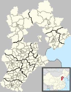 Hengshui Location of the city centre in Hebei | |
| Coordinates: 37°44′N 115°42′E / 37.733°N 115.700°E | |
| Country | People's Republic of China |
| Province | Hebei |
| Area | |
| • Prefecture-level city | 8,836.95 km2 (3,411.97 sq mi) |
| • Urban (2018)[1] | 168 km2 (65 sq mi) |
| • Metro | 602.5 km2 (232.6 sq mi) |
| Population (2010 census) | |
| • Prefecture-level city | 4,340,773 |
| • Density | 490/km2 (1,300/sq mi) |
| • Urban (2018)[1] | 550,000 |
| • Urban density | 3,300/km2 (8,500/sq mi) |
| • Metro | 522,147 |
| • Metro density | 870/km2 (2,200/sq mi) |
| Time zone | UTC+8 (China Standard) |
| ISO 3166 code | CN-HE-11 |
| License Plate Prefix | 冀T |
Hengshui (pinyin: Héngshuǐ) is a prefecture-level city in southern Hebei province, People's Republic of China, bordering Shandong to the southeast. At the 2010 census its population was 4,340,373 inhabitants whom 522,147 lived in the built-up (or metro) area made of Taocheng urban district.[2] It is on the Jingjiu Railway.
Administrative divisions
| Map | ||||||
|---|---|---|---|---|---|---|
| # | Name | Hanzi | Hanyu Pinyin | Population (2010 census) | Area (km²) | Density (/km²) |
| 1 | Taocheng District | 桃城区 | Táochéng Qū | 522,147 | 602.5 | 867 |
| 2 | Jizhou District | 冀州区 | Jìzhōu Qū | 362,013 | 918 | 394 |
| 3 | Shenzhou City | 深州市 | Shēnzhōu Shì | 566,087 | 1,244 | 455 |
| 4 | Zaoqiang County | 枣强县 | Zǎoqiáng Xiàn | 391,469 | 903 | 4371 |
| 5 | Wuyi County | 武邑县 | Wǔyì Xiàn | 315,693 | 830 | 380 |
| 6 | Wuqiang County | 武强县 | Wǔqiáng Xiàn | 214,549 | 442 | 485 |
| 7 | Raoyang County | 饶阳县 | Ráoyáng Xiàn | 280,498 | 573 | 490 |
| 8 | Anping County | 安平县 | Ānpíng Xiàn | 328,512 | 493 | 666 |
| 9 | Gucheng County | 故城县 | Gùchéng Xiàn | 487,025 | 941 | 518 |
| 10 | Jing County | 景县 | Jǐng Xiàn | 528,693 | 1,183 | 447 |
| 11 | Fucheng County | 阜城县 | Fùchéng Xiàn | 341,087 | 698 | 489 |

Education
Hengshui High School and Hengshui University[3] are located in Hengshui.
Sights

The Harrison International Peace Hospital is located in Hengshui. This comprehensive teaching and research hospital was named after Dr. Tillson Harrison, a martyr to the Chinese revolution. Dr. Harrison, a Canadian, died in 1947 while transporting medical equipment and supplies. Some of this equipment is on display in an exhibition room in the hospital. The hospital uses both traditional Chinese medicine and modern western diagnostic and therapeutic technology.
The city is renowned as the centre for inside painting, mainly of small snuff bottles. Zhang Rucai was born in Hebei Province and since 1972, he started to learn the art of inside painting. In April 1996, he was conferred the title Master of Chinese Folk Arts & Crafts by UNESCO. The city has a fascinating museum and exhibition of the art of the inside painter - many complex paintings done on the inside of small snuff bottles as well as special larger pieces of glassware.[4]
There is a Buddhist Temple on the outskirts of the city which is well worth a visit, as is the bridge in the old part of the city - one of the few remnants of the old town.
 Hengshui Old Town Bridge
 Hengshui Buddhist Temple
Air pollution
As air pollution in China is at an all-time high, several Hebei cities are among the most polluted cities and have the worst air quality in China. Reporting on China's airpocalypse has been accompanied by what seems like a monochromatic slideshow of the country's several cities smothered in thick smog.
According to a survey made by "Global voices China" in February 2013, 7 cities in Hebei including Xingtai, Shijiazhuang, Baoding, Handan, Langfang, Hengshui and Tangshan, are among China's 10 most polluted cities.[5]
Religion
Hengshui is the seat of the Catholic Diocese of Hengshui.
References
- 1 2 Cox, Wendell (2018). Demographia World Urban Areas. 14th Annual Edition (PDF). St. Louis: Demographia. p. 22.
- ↑ "China: Hébĕi (Prefectures, Cities, Districts and Counties) - Population Statistics, Charts and Map". Citypopulation.de. Retrieved 2 October 2017.
- ↑ "Archived copy". Archived from the original on 2007-08-03. Retrieved 2007-09-29.
- ↑ Archived 2011-02-07 at the Wayback Machine.
- ↑ Bildner, Eli (February 27, 2013). "Interactive Maps of China's Most–and Least–Polluted Places". Global Voices China. Archived from the original on 3 September 2014. Retrieved 1 September 2014.
| Wikimedia Commons has media related to Hengshui. |