Cass County, North Dakota
| Cass County, North Dakota | |
|---|---|
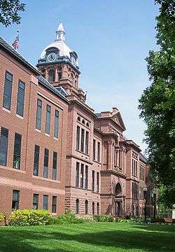 Cass County Courthouse in Fargo | |
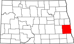 Location in the U.S. state of North Dakota | |
 North Dakota's location in the U.S. | |
| Founded | October 27, 1873 |
| Named for | George Washington Cass |
| Seat | Fargo |
| Largest city | Fargo |
| Area | |
| • Total | 1,768 sq mi (4,579 km2) |
| • Land | 1,765 sq mi (4,571 km2) |
| • Water | 3.0 sq mi (8 km2), 0.2% |
| Population (est.) | |
| • (2017) | 177,787[1] |
| • Density | 101/sq mi (39/km2) |
| Congressional district | At-large |
| Time zone | Central: UTC−6/−5 |
| Website |
www |
Cass County is a county located in the U.S. state of North Dakota. As of the 2010 census, the population was 149,778, and was estimated to be 175,249 in 2016.[2] Cass County is the most populous county in North Dakota, accounting for nearly 23% of the state's population in 2016.[3][4] Its county seat is Fargo,[5] the most populous city in the state. The county was organized on October 27, 1873.[6][7]
Cass County is part of the Fargo, ND-MN Metropolitan Statistical Area.
History
Cass County dates back to the days of the Dakota Territory. It was one of the original counties defined in 1872, and was organized on October 27, 1873, at a meeting in Fargo. It was named after railroad executive George Washington Cass (1810 - 1888).[8]
Geography
According to the U.S. Census Bureau, the county has a total area of 1,768 square miles (4,580 km2), of which 1,765 square miles (4,570 km2) is land and 3.0 square miles (7.8 km2) (0.2%) is water.[9]
Major highways


Adjacent counties
- Traill County (north)
- Norman County, Minnesota (northeast)
- Clay County, Minnesota (east)
- Richland County (southeast)
- Ransom County (southwest)
- Barnes County (west)
- Steele County (northwest)
Demographics
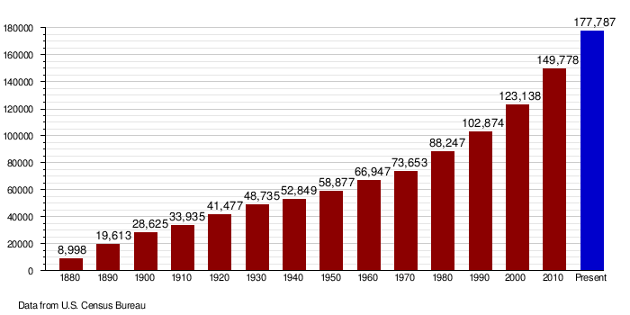
| Historical population | |||
|---|---|---|---|
| Census | Pop. | %± | |
| 1880 | 8,998 | — | |
| 1890 | 19,613 | 118.0% | |
| 1900 | 28,625 | 45.9% | |
| 1910 | 33,935 | 18.6% | |
| 1920 | 41,477 | 22.2% | |
| 1930 | 48,735 | 17.5% | |
| 1940 | 52,849 | 8.4% | |
| 1950 | 58,877 | 11.4% | |
| 1960 | 66,947 | 13.7% | |
| 1970 | 73,653 | 10.0% | |
| 1980 | 88,247 | 19.8% | |
| 1990 | 102,874 | 16.6% | |
| 2000 | 123,138 | 19.7% | |
| 2010 | 149,778 | 21.6% | |
| Est. 2017 | 177,787 | [10] | 18.7% |
| U.S. Decennial Census[11] 1790-1960[12] 1900-1990[13] 1990-2000[14] 2010-2016[2] | |||
2000 census
As of the census of 2000, there were 123,138 people, 51,315 households, and 29,814 families residing in the county. The population density was 70 people per square mile (27/km²). There were 53,790 housing units at an average density of 30 per square mile (12/km²). The racial makeup of the county was 95.10% White, 0.81% Black or African American, 1.08% Native American, 1.26% Asian, 0.03% Pacific Islander, 0.43% from other races, and 1.29% from two or more races. 1.23% of the population were Hispanic or Latino of any race. 34.1% were of German and 32.4% Norwegian ancestry.
There were 51,315 households out of which 29.9% had children under the age of 18 living with them, 47.3% were married couples living together, 7.6% had a female householder with no husband present, and 41.9% were non-families. 31.2% of all households were made up of individuals and 7.6% had someone living alone who was 65 years of age or older. The average household size was 2.32 and the average family size was 2.98.
In the county, the population was spread out with 23.4% under the age of 18, 16.0% from 18 to 24, 31.3% from 25 to 44, 19.6% from 45 to 64, and 9.7% who were 65 years of age or older. The median age was 31 years. For every 100 females, there were 100.3 males. For every 100 females age 18 and over, there were 99.5 males.
The median income for a household in the county was $38,147, and the median income for a family was $51,469. Males had a median income of $32,216 versus $22,300 for females. The per capita income for the county was $20,889. About 5.7% of families and 10.1% of the population were below the poverty line, including 9.1% of those under age 18 and 8.1% of those age 65 or over.
2010 census
As of the 2010 United States Census, there were 149,778 people, 63,899 households, and 35,215 families residing in the county.[15] The population density was 84.9 inhabitants per square mile (32.8/km2). There were 67,938 housing units at an average density of 38.5 per square mile (14.9/km2).[16] The racial makeup of the county was 91.7% white, 2.4% Asian, 2.3% black or African American, 1.2% American Indian, 0.5% from other races, and 1.9% from two or more races. Those of Hispanic or Latino origin made up 2.0% of the population.[15] In terms of ancestry, 45.4% were German, 35.8% were Norwegian, 9.2% were Irish, 6.3% were Swedish, and 1.7% were American.[17]
Of the 63,899 households, 27.8% had children under the age of 18 living with them, 42.9% were married couples living together, 8.3% had a female householder with no husband present, 44.9% were non-families, and 33.0% of all households were made up of individuals. The average household size was 2.27 and the average family size was 2.94. The median age was 31.5 years.[15]
The median income for a household in the county was $47,600 and the median income for a family was $68,858. Males had a median income of $42,557 versus $31,916 for females. The per capita income for the county was $28,184. About 5.8% of families and 12.8% of the population were below the poverty line, including 11.0% of those under age 18 and 10.1% of those age 65 or over.[18]
Population by decade
Government
Cass County is governed by a board of commissioners, each elected to a four-year term. Other elected officials include the auditor, recorder, sheriff, state's attorney, and treasurer. Appointed officials include administrator, extension agent, director of tax equalization, highway engineer, information technology coordinator, social services officer, veterans service officer, and weed control officer.
| District | Commissioner | In office since | Current term expires in |
|---|---|---|---|
| 1st | Chad Peterson | 2012 | 2016 |
| 2nd | Vern Bennett (Chair) | 2002 | 2014 |
| 3rd | Ken Pawluk | 2004 | 2016 |
| 4th | Darrell Vanyo (Vice Chair) | 2002 | 2014 |
| 5th | Mary Scherling | 2012 | 2016 |
The current Sheriff is Paul D. Laney. Laney has served as Sheriff of Cass County since January 2, 2007.
| Year | Republican | Democratic | Third parties |
|---|---|---|---|
| 2016 | 49.3% 39,816 | 38.8% 31,361 | 11.9% 9,644 |
| 2012 | 49.9% 36,855 | 47.0% 34,712 | 3.1% 2,288 |
| 2008 | 45.3% 32,566 | 52.4% 37,622 | 2.3% 1,646 |
| 2004 | 59.4% 39,619 | 39.0% 26,010 | 1.6% 1,082 |
| 2000 | 56.9% 33,536 | 36.4% 21,451 | 6.8% 4,008 |
| 1996 | 48.0% 24,238 | 43.0% 21,693 | 9.0% 4,540 |
| 1992 | 47.7% 25,312 | 34.0% 18,077 | 18.3% 9,727 |
| 1988 | 54.3% 26,699 | 45.0% 22,107 | 0.7% 331 |
| 1984 | 61.4% 29,221 | 37.9% 18,054 | 0.7% 354 |
| 1980 | 54.8% 23,886 | 31.1% 13,562 | 14.2% 6,172 |
| 1976 | 54.5% 22,583 | 43.2% 17,879 | 2.3% 949 |
| 1972 | 60.0% 21,770 | 38.8% 14,073 | 1.3% 463 |
| 1968 | 55.9% 15,240 | 39.7% 10,819 | 4.5% 1,212 |
| 1964 | 45.3% 12,972 | 54.7% 15,674 | 0.1% 23 |
| 1960 | 58.9% 17,498 | 41.1% 12,213 | |
| 1956 | 63.3% 16,932 | 36.7% 9,821 | 0.1% 17 |
| 1952 | 66.2% 18,094 | 33.6% 9,193 | 0.2% 57 |
| 1948 | 52.3% 11,430 | 45.5% 9,937 | 2.2% 469 |
| 1944 | 50.4% 10,661 | 49.1% 10,390 | 0.6% 116 |
| 1940 | 51.1% 12,567 | 48.5% 11,911 | 0.4% 108 |
| 1936 | 35.2% 7,632 | 57.2% 12,400 | 7.6% 1,638 |
| 1932 | 43.8% 8,937 | 54.4% 11,094 | 1.8% 363 |
| 1928 | 66.2% 12,480 | 33.5% 6,315 | 0.3% 63 |
| 1924 | 65.9% 9,906 | 9.0% 1,352 | 25.2% 3,783 |
| 1920 | 77.0% 10,735 | 20.2% 2,817 | 2.8% 386 |
| 1916 | 46.7% 3,093 | 49.9% 3,303 | 3.5% 230 |
| 1912 | 26.2% 1,316 | 36.1% 1,814 | 37.6% 1,889[20] |
| 1908 | 62.5% 3,681 | 34.0% 2,000 | 3.5% 206 |
| 1904 | 80.4% 3,788 | 12.9% 609 | 6.7% 314 |
| 1900 | 65.7% 3,485 | 30.8% 1,636 | 3.5% 185 |
Communities

Cities
Townships
- Addison
- Amenia
- Arthur
- Ayr
- Barnes
- Bell
- Berlin
- Buffalo
- Casselton
- Clifton
- Cornell
- Davenport
- Dows
- Durbin
- Eldred
- Empire
- Erie
- Everest
- Fargo
- Gardner
- Gill
- Gunkel
- Harmony
- Harwood
- Highland
- Hill
- Howes
- Hunter
- Kinyon
- Lake
- Leonard
- Maple River
- Mapleton
- Noble
- Normanna
- Page
- Pleasant
- Pontiac
- Raymond
- Reed
- Rich
- Rochester
- Rush River
- Stanley
- Tower
- Walburg
- Warren
- Watson
- Wheatland
- Wiser
Census-designated places
Other communities
See also
References
- ↑ "QuickFacts. Cass County, North Dakota". Census.gov. Retrieved June 28, 2018.
- 1 2 "State & County QuickFacts". United States Census Bureau. Retrieved October 31, 2013.
- ↑ Based on 2016 Census. 175,249 (Cass pop.) / 757,952 (ND pop.) = 22.50%
- ↑ "Top 100 Counties by Growth, 2013". United States Census Bureau. Retrieved March 28, 2014.
- ↑ "Find a County". National Association of Counties. Archived from the original on 2011-05-31. Retrieved 2011-06-07.
- ↑ "Dakota Territory, South Dakota, and North Dakota: Individual County Chronologies". Dakota Territory Atlas of Historical County Boundaries. The Newberry Library. 2006. Retrieved February 2, 2015.
- ↑ "County History". North Dakota.gov. The State of North Dakota. Retrieved February 2, 2015.
- ↑ Gannett, Henry (1905). The Origin of Certain Place Names in the United States. Govt. Print. Off. p. 71.
- ↑ "2010 Census Gazetteer Files". United States Census Bureau. August 22, 2012. Archived from the original on January 29, 2015. Retrieved January 28, 2015.
- ↑ "Population and Housing Unit Estimates". Retrieved June 9, 2017.
- ↑ "U.S. Decennial Census". United States Census Bureau. Archived from the original on April 22, 2013. Retrieved January 28, 2015.
- ↑ "Historical Census Browser". University of Virginia Library. Retrieved January 28, 2015.
- ↑ Forstall, Richard L., ed. (March 27, 1995). "Population of Counties by Decennial Census: 1900 to 1990". United States Census Bureau. Retrieved January 28, 2015.
- ↑ "Census 2000 PHC-T-4. Ranking Tables for Counties: 1990 and 2000" (PDF). United States Census Bureau. April 2, 2001. Retrieved January 28, 2015.
- 1 2 3 "DP-1 Profile of General Population and Housing Characteristics: 2010 Demographic Profile Data". United States Census Bureau. Retrieved 2016-03-14.
- ↑ "Population, Housing Units, Area, and Density: 2010 - County". United States Census Bureau. Retrieved 2016-03-14.
- ↑ "DP02 SELECTED SOCIAL CHARACTERISTICS IN THE UNITED STATES – 2006-2010 American Community Survey 5-Year Estimates". United States Census Bureau. Retrieved 2016-03-14.
- ↑ "DP03 SELECTED ECONOMIC CHARACTERISTICS – 2006-2010 American Community Survey 5-Year Estimates". United States Census Bureau. Retrieved 2016-03-14.
- ↑ Leip, David. "Dave Leip's Atlas of U.S. Presidential Elections". uselectionatlas.org. Retrieved 2018-04-12.
- ↑ The leading "other" candidate, Progressive Theodore Roosevelt, received 1,316 votes, while Socialist candidate Eugene Debs received 164 votes, Prohibition candidate Eugene Chafin received 56 votes.
External links
Places adjacent to Cass County, North Dakota | ||||||||||
|---|---|---|---|---|---|---|---|---|---|---|
| ||||||||||
Municipalities and communities of Cass County, North Dakota, United States | ||
|---|---|---|
| Cities | | |
| Townships | ||
| CDPs | ||
| Unincorporated communities | ||
| Footnotes | ‡This populated place also has portions in an adjacent county or counties | |
| Counties | ||
|---|---|---|
| Main cities | ||
| Surrounding areas |
| |
‡ - county seat | ||
