Bačka Topola
| Bačka Topola Бачка Топола Topolya | ||
|---|---|---|
| Town and municipality | ||
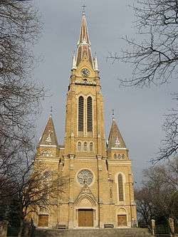 Visitation of Our Lady Catholic Church | ||
| ||
 Location of the municipality of Bačka Topola within Serbia | ||
| Coordinates: 45°49′N 19°38′E / 45.817°N 19.633°ECoordinates: 45°49′N 19°38′E / 45.817°N 19.633°E | ||
| Country |
| |
| Province | Vojvodina | |
| District | North Bačka | |
| Settlements | 23 | |
| Government | ||
| • Mayor | Gábor Kislinder (SVM) | |
| Area[1] | ||
| • Municipality | 596 km2 (230 sq mi) | |
| Elevation | 102 m (335 ft) | |
| Population (2011 census)[2] | ||
| • Town | 14,573 | |
| • Municipality | 33,321 | |
| Time zone | UTC+1 (CET) | |
| • Summer (DST) | UTC+2 (CEST) | |
| Postal code | 24300 | |
| Area code | +381 24 | |
| Car plates | BT | |
| Website |
www | |


Bačka Topola (Serbian Cyrillic: Бачка Топола, pronounced [bâːtʃkaː topǒla]; Hungarian: Topolya, pronounced [ˈtopojɒ]) is a town and municipality located in the North Bačka District of the autonomous province of Vojvodina, Serbia. The municipality is composed of 23 local communities and has a population of 33,321, while the town itself has 14,573 inhabitants.
Name
The name of the town is derived from the Serbian word topola (топола) ("poplar" in English). The first part of the name of the town was given to designate its location in the region of Bačka in contrast to places with similar names, like Topola in Šumadija or Banatska Topola in Banat.

History
The town was mentioned first in 1462 under name Fibaych. This settlement was destroyed in the 16th century and new smaller settlement was later built at its location. Name Topola was first recorded in 1543, while according to the Ottoman defters from 1580, 1582, and 1590, it was mentioned as a village, whose population numbered between 21 and 23 houses. In this time, the inhabitants of the settlement were Serbs. In 1704, Topola was destroyed by kuruc rebels.
In 1731, Topola was mentioned as an uninhabited heath. In 1750, the new settlement was founded at this location and 200 Hungarian and Slovak families arrived here from Upper Hungary. It was a district center in Bács-Bodrog County as "Topolya" until 1918, when it became part of Kingdom of Serbs, Croats and Slovenes (renamed to Yugoslavia in 1929). It was part of Yugoslavia until 1991, with the exception of Hungarian occupation between 1941 and 1944 during World War II.
Inhabited places
Bačka Topola municipality includes the town of Bačka Topola and the following villages:
- Bagremovo (Hungarian: Brazília or Bárdossyfalva)
- Bački Sokolac
- Bajša (Hungarian: Bajsa)
- Bogaraš (Hungarian: Bodaras or Félváros)
- Gornja Rogatica
- Gunaroš (Hungarian: Gunaras)
- Karađorđevo
- Kavilo (Hungarian: Rákócitelep or Kavilló)
- Krivaja
- Mali Beograd
- Mićunovo
- Njegoševo
- Novo Orahovo (Hungarian: Zentagunaras)
- Obornjača (Hungarian: Nagyvölgy)
- Pačir (Hungarian: Pacsér)
- Panonija
- Pobeda (Hungarian: Győztes)
- Srednji Salaš
- Stara Moravica (Hungarian: Bácskossuthfalva)
- Svetićevo
- Tomislavci
- Zobnatica (Hungarian: Andrásnépe)
Note: For the inhabited places with an absolute or relative Hungarian ethnic majority, the names are also given in Hungarian.
Demographics
| Historical population | ||
|---|---|---|
| Year | Pop. | ±% p.a. |
| 1948 | 43,135 | — |
| 1953 | 43,243 | +0.05% |
| 1961 | 44,466 | +0.35% |
| 1971 | 43,508 | −0.22% |
| 1981 | 41,889 | −0.38% |
| 1991 | 40,473 | −0.34% |
| 2002 | 38,245 | −0.51% |
| 2011 | 33,321 | −1.52% |
| Source: [3] | ||
According to the 2011 census results, the municipality of Bačka Topola has a population of 33,321 inhabitants.
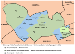
Ethnic groups
- Municipality
The population of the Bačka Topola municipality is composed of:[4]
- Hungarians = 19,307 (57.94%)
- Serbs = 9,830 (29.50%)
- Montenegrins = 349 (1.05%)
- Croats = 330 (0.99%)
- Others and undeclared = 3,505 (10.51%)
Local communities with a Hungarian majority are: Bačka Topola (Hungarian: Topolya), Bajša (Hungarian: Bajsa), Pačir (Hungarian: Pacsér), Stara Moravica (Hungarian: Bácskossuthfalva), Zobnatica (Hungarian: Andrásnépe), Bogaraš (Hungarian: Bogaras-Felváros), Obornjača (Hungarian: Nagyvölgy), Bagremovo (Hungarian: Brazília), Gunaroš (Hungarian: Gunaras), Novo Orahovo (Hungarian: Zentagunaras), and Kavilo (Hungarian: Rákóczifalu or Kavilló).
Local communities with a Serb majority are: Gornja Rogatica, Srednji Salaš, Panonija, Orešković, Bački Sokolac, Karađorđevo, Mićunovo, Njegoševo, Krivaja, Svetićevo, and Mali Beograd.
Pobeda (Hungarian: Győztes or Pobedabirtok) is an ethnically-mixed local community with a Hungarian relative majority. Krivaja, Mali Beograd, and Svetićevo have over 20% Hungarians, as well as other minorities, while Bačka Topola, Pačir, Zobnatica, and Pobeda have over 20% Serbs.
- Town
The population of the Bačka Topola town is composed of:
- Hungarians = 9,582 (59.25%)
- Serbs = 4,699 (29.06%)
- Montenegrins = 426 (2.63%)
- Yugoslavs = 376 (2.33%)
- Croats = 170 (1.05%)
- Others.
Economy
The following table gives a preview of total number of employed people per their core activity (as of 2016):[5]
| Activity | Total |
|---|---|
| Agriculture, forestry and fishing | 1,142 |
| Mining | - |
| Processing industry | 2,346 |
| Distribution of power, gas and water | 44 |
| Distribution of water and water waste management | 83 |
| Construction | 158 |
| Wholesale and retail, repair | 993 |
| Traffic, storage and communication | 205 |
| Hotels and restaurants | 166 |
| Media and telecommunications | 93 |
| Finance and insurance | 110 |
| Property stock and charter | 7 |
| Professional, scientific, innovative and technical activities | 195 |
| Administrative and other services | 115 |
| Administration and social assurance | 340 |
| Education | 598 |
| Healthcare and social work | 486 |
| Art, leisure and recreation | 59 |
| Other services | 112 |
| Total | 7,253 |
Politics
Results of 2008 local elections in Bačka Topola municipality:
- Hungarian Coalition (46.25%)
- For a European municipality Bačka Topola (20.25%)
- Serbian Radical Party (15.62%)
- "List for Serbia" (8.33%)
Sport
The most popular local football team is TSC Bačka Topola, that plays in the Serbian First League (2nd national tier).
Notable people
- Branko Bošković former football player
- Andrija Kaluđerović football player
- Félix Lajkó violinist, zither player, composer, movie actor
- Dušan Tadić football player
- Nikola Žigić former football player
- György Mezey former football player and manager
- Branislav Simić Greco-Roman wrestler, Olympic champion
- Eleonora Wild former basketball player, Olympic and World Championship silver medalist
- István Dudás former football player
- Paul Kray soldier
International relations
Twin towns — Sister cities
Bačka Topola is twinned with:
See also
References
- Slobodan Ćurčić, Broj stanovnika Vojvodine, Novi Sad, 1996.
- ↑ "Municipalities of Serbia, 2006". Statistical Office of Serbia. Retrieved 2010-11-28.
- ↑ "2011 Census of Population, Households and Dwellings in the Republic of Serbia: Comparative Overview of the Number of Population in 1948, 1953, 1961, 1971, 1981, 1991, 2002 and 2011, Data by settlements" (PDF). Statistical Office of Republic Of Serbia, Belgrade. 2014. ISBN 978-86-6161-109-4. Retrieved 2014-06-27.
- ↑ "2011 Census of Population, Households and Dwellings in the Republic of Serbia" (PDF). stat.gov.rs. Statistical Office of the Republic of Serbia. Retrieved 19 March 2017.
- ↑ "Population by ethnicity – Bačka Topola". Statistical Office of the Republic of Serbia (SORS). Retrieved 23 February 2013.
- ↑ "ОПШТИНЕ И РЕГИОНИ У РЕПУБЛИЦИ СРБИЈИ, 2017" (PDF). stat.gov.rs (in Serbian). Statistical Office of the Republic of Serbia. Retrieved 16 March 2018.
External links
| Wikimedia Commons has media related to Bačka Topola. |
- Official site
- Live cameras from Bačka Topola
- History of Bačka Topola (in Hungarian)
- Crveni krst Bačka Topola
Cities, towns and villages in the North Bačka District | ||
|---|---|---|
| Subotica | 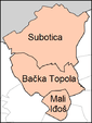 | |
| Bačka Topola | ||
| Mali Iđoš | ||
(*) bold are municipalities or cities | ||


