Veliko Gradište
| Veliko Gradište Велико Градиште | ||
|---|---|---|
| Town and municipality | ||
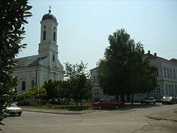 Town center of Veliko Gradiste and Orthodox church | ||
| ||
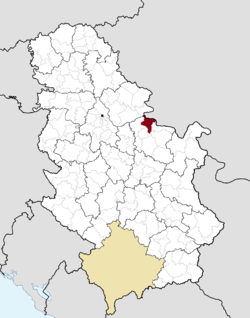 Location of the municipality of Veliko Gradište within Serbia | ||
| Coordinates: 44°45′N 21°31′E / 44.750°N 21.517°ECoordinates: 44°45′N 21°31′E / 44.750°N 21.517°E | ||
| Country |
| |
| Region | Southern and Eastern Serbia | |
| District | Braničevo | |
| Settlements | 26 | |
| Government | ||
| • Mayor | Dragan Milić | |
| Area[1] | ||
| • Town | 18.36 km2 (7.09 sq mi) | |
| • Municipality | 344.05 km2 (132.84 sq mi) | |
| Elevation | 72 m (236 ft) | |
| Population (2011 census)[2] | ||
| • Town | 6,204 | |
| • Town density | 340/km2 (880/sq mi) | |
| • Municipality | 17,610 | |
| • Municipality density | 51/km2 (130/sq mi) | |
| Time zone | UTC+1 (CET) | |
| • Summer (DST) | UTC+2 (CEST) | |
| Postal code | 12220 | |
| Area code | +381(0)12 | |
| Car plates | PO | |
| Climate | Cfb | |
| Website |
www | |
Veliko Gradište (Serbian Cyrillic: Велико Градиште, pronounced [ʋělikoː ɡrâdiːʃte]) is a town and municipality located in the Braničevo District of the eastern Serbia. It is situated the right bank of the Danube river and left bank of the Pek river. In 2011, the town has a total population of 6,204, while the municipality has 17,610.
History
Thracians and Dacians lived in the region prior to the Roman conquering of the Balkans in the 1st century BC, when the town was known as "Pincum", in the province of Upper Moesia. The Pincum relief of the Trojan Cycle depicting Achilles and Hector was found in Ritopek.[3]
Name
The name means "big construction site" in Serbian. Names in other languages: Romanian: Gradiştea Mare.
Settlements
Aside from the town of Veliko Gradište, the municipality includes the following settlements:
Ethnic groups
Ethnic groups in the Veliko Gradište municipality (2011 census):
Climate
| Climate data for Veliko Gradište (1981–2010, extremes 1961–2010) | |||||||||||||
|---|---|---|---|---|---|---|---|---|---|---|---|---|---|
| Month | Jan | Feb | Mar | Apr | May | Jun | Jul | Aug | Sep | Oct | Nov | Dec | Year |
| Record high °C (°F) | 17.5 (63.5) |
22.2 (72) |
28.0 (82.4) |
30.4 (86.7) |
35.3 (95.5) |
38.6 (101.5) |
43.6 (110.5) |
40.6 (105.1) |
36.1 (97) |
31.1 (88) |
27.1 (80.8) |
17.7 (63.9) |
43.6 (110.5) |
| Average high °C (°F) | 3.5 (38.3) |
6.1 (43) |
11.9 (53.4) |
18.0 (64.4) |
23.3 (73.9) |
26.4 (79.5) |
28.9 (84) |
29.0 (84.2) |
23.8 (74.8) |
17.7 (63.9) |
10.3 (50.5) |
4.6 (40.3) |
16.9 (62.4) |
| Daily mean °C (°F) | 0.1 (32.2) |
1.5 (34.7) |
6.2 (43.2) |
11.8 (53.2) |
17.0 (62.6) |
19.9 (67.8) |
21.9 (71.4) |
21.5 (70.7) |
16.8 (62.2) |
11.7 (53.1) |
6.0 (42.8) |
1.4 (34.5) |
11.3 (52.3) |
| Average low °C (°F) | −2.9 (26.8) |
−2.4 (27.7) |
1.4 (34.5) |
6.1 (43) |
11.0 (51.8) |
13.7 (56.7) |
15.2 (59.4) |
15.1 (59.2) |
11.4 (52.5) |
7.2 (45) |
2.4 (36.3) |
−1.5 (29.3) |
6.4 (43.5) |
| Record low °C (°F) | −26.4 (−15.5) |
−22.6 (−8.7) |
−19.6 (−3.3) |
−7.9 (17.8) |
−1.0 (30.2) |
2.4 (36.3) |
5.9 (42.6) |
5.7 (42.3) |
−2.1 (28.2) |
−6.9 (19.6) |
−14.2 (6.4) |
−19.4 (−2.9) |
−26.4 (−15.5) |
| Average precipitation mm (inches) | 45.0 (1.772) |
42.2 (1.661) |
41.5 (1.634) |
57.2 (2.252) |
59.8 (2.354) |
81.6 (3.213) |
61.4 (2.417) |
55.9 (2.201) |
57.5 (2.264) |
51.8 (2.039) |
48.4 (1.906) |
50.7 (1.996) |
653.0 (25.709) |
| Average precipitation days (≥ 0.1 mm) | 13 | 12 | 12 | 13 | 13 | 13 | 10 | 9 | 10 | 10 | 11 | 14 | 138 |
| Average snowy days | 9 | 8 | 4 | 0 | 0 | 0 | 0 | 0 | 0 | 0 | 3 | 8 | 31 |
| Average relative humidity (%) | 83 | 77 | 69 | 67 | 68 | 70 | 68 | 67 | 72 | 74 | 78 | 83 | 73 |
| Mean monthly sunshine hours | 67.2 | 95.5 | 151.8 | 183.5 | 235.6 | 257.0 | 291.3 | 280.5 | 203.9 | 156.8 | 92.1 | 58.6 | 2,073.8 |
| Source: Republic Hydrometeorological Service of Serbia[4] | |||||||||||||
See also
References
- ↑ "Municipalities of Serbia, 2006". Statistical Office of Serbia. Retrieved 2010-11-28.
- ↑ "2011 Census of Population, Households and Dwellings in the Republic of Serbia: Comparative Overview of the Number of Population in 1948, 1953, 1961, 1971, 1981, 1991, 2002 and 2011, Data by settlements" (PDF). Statistical Office of Republic Of Serbia, Belgrade. 2014. ISBN 978-86-6161-109-4. Retrieved 2014-06-27.
- ↑ Heroic themes of the Trojan War cycle in Roman funerary art example of a relief from Pincum. Balcanica, (37), 25-45.
- ↑ "Monthly and annual means, maximum and minimum values of meteorological elements for the period 1981 - 2010" (in Serbian). Republic Hydrometeorological Service of Serbia. Retrieved March 18, 2017.
External links
| Wikimedia Commons has media related to Veliko Gradište. |
Capital: Veliko Gradište | ||
| Villages |  | |
| Landmarks |
| |
| Culture |
| |
| Notable people | ||
