Zaječar
| Zaječar Град Зајечар Saitchar | ||
|---|---|---|
| City | ||
| City of Zaječar | ||
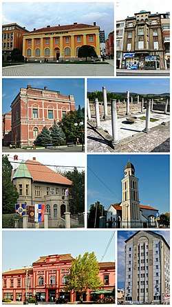 City of Zaječar- photomontage | ||
| ||
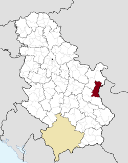 Location of the city of Zaječar within Serbia | ||
| Coordinates: 43°55′N 22°18′E / 43.917°N 22.300°ECoordinates: 43°55′N 22°18′E / 43.917°N 22.300°E | ||
| Country |
| |
| Region | Southern and Eastern Serbia | |
| District | Zaječar | |
| Settlements | 41 | |
| Government | ||
| • Mayor | Boško Ničić (SNS) | |
| Area[1] | ||
| • Urban | 97 km2 (37 sq mi) | |
| • Administrative | 1,069 km2 (413 sq mi) | |
| Elevation | 134 m (440 ft) | |
| Population (2011 census)[2] | ||
| • Urban | 43,860 | |
| • Urban density | 450/km2 (1,200/sq mi) | |
| • Administrative | 59,461 | |
| • Administrative density | 56/km2 (140/sq mi) | |
| Time zone | UTC+1 (CET) | |
| • Summer (DST) | UTC+2 (CEST) | |
| Postal code | 19000 | |
| Area code | +381(0)19 | |
| Car plates | ZA | |
| Website |
www | |

Zaječar (Serbian Cyrillic: Зајечар pronounced [zâjɛtʃar], Romanian: Zaicear) is a city and the administrative center of the Zaječar District in eastern Serbia. According to the 2011 census, the city administrative area has a population of 59,461 inhabitants. City is also the largest place in eastern Serbia.
Zaječar is widely known for its rock music festival Gitarijada and for the festival dedicated to contemporary art ZALET.
Name
In Serbian, the city is known as Zaječar (Зајечар); in Romanian as Zăiicer (archaic name), Zăiceri, Zăicear or Zăiceari; in Macedonian as Заечар and in Bulgarian as Зайчар (Zajčar).
The origin of the name is from the Torlak dialect name for "hare" = zajec / зајец (in all other Serbian dialects it is zec / зец, while in Bulgarian it is "заек / zaek"). It means "the man who breeds and keeps hares".
Folk etymology in Romanian/Vlach, gives "Zāiicer" as meaning "the Gods are asking (for sacrifice)".
Early renderings of the city in English favored Saitchar.
History
Ancient
Three Roman Emperors were born in the city of Zaječar: Galerius (r. 293–311), Maximinus (r. 305–312) and Licinius (r. 308–324).
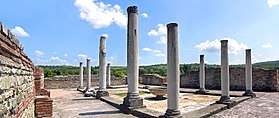
The Late Roman fortified palace compound and memorial complex of Gamzigrad-Romuliana at the outskirts of Zaječar was commissioned by Emperor Caius Valerius Galerius Maximianus, in the late 3rd and early 4th century. It was known as Felix Romuliana, named after the Emperor's mother Romula. The site consists of fortifications, the palace in the north-western part of the complex, basilicas, temples, hot baths, memorial complex, and a tetrapylon. The site offers a unique testimony of the Roman building tradition marked by the ideology of the period of the Second Tetrachy. The group of buildings is also unique in its intertwining of ceremonial and memorial functions. The relation between two spatial ensembles in this site is stressed by the tetrapylon which is placed on the crossroads between the worldly fortification and palace on the one side and the other-worldly mausoleums and consecration monuments on the other.
Middle Ages
Slavs entered the region during the 7th century, and the tribe living in the area was called Timočani. During the Middle Ages, the area of Zaječar was contested between Bulgaria, Hungary and Serbia. It finally fell under Ottoman rule during the first half of the 15th century. The oldest preserved rendering of Zaječar listed in an Ottoman defter dates from 1466. At the time, there were only eight extended families (zadrugas) living there.
Modern
In the First Serb Uprising, Hajduk Veljko Petrović liberated the area from Ottoman rule in 1806. The Ottomans retook the area in 1813 but finally ceded it to Serbia in 1833.
The population of the city and of the area to the south of it was partly Bulgarian, as the Serbian ethnographer Milan Đ. Milićević recognized. The city actively participated in the Serbo-Turkish War of 1876-1878. In 1883, it was partially engulfed in the famous Timok Uprising, a reaction against a governmental order to confiscate peasants' firearms and against a law replacing the militia with a standing army.
Bulgaria occupied Zaječar from 1915 to 1918, during the First World War. From 1929 to 1941, the city was part of the Morava Banovina of the Kingdom of Yugoslavia. The German army occupied Zaječar on 14 April 1941, during the Second World War; it was administered as part of the Territory of the Military Commander in Serbia from 22 April 1941. Zaječar was liberated on 7–8 October 1944 in a joint operation by Yugoslav Partisans and the Red Army.[3]
Climate
Zaječar has a humid continental climate (Köppen climate classification: Dfa), that's very close to a humid subtropical climate (Köppen climate classification: Cfa).
| Climate data for Zaječar (1981–2010, extremes 1961–2010) | |||||||||||||
|---|---|---|---|---|---|---|---|---|---|---|---|---|---|
| Month | Jan | Feb | Mar | Apr | May | Jun | Jul | Aug | Sep | Oct | Nov | Dec | Year |
| Record high °C (°F) | 23.0 (73.4) |
25.1 (77.2) |
28.4 (83.1) |
34.2 (93.6) |
35.7 (96.3) |
40.4 (104.7) |
44.7 (112.5) |
41.7 (107.1) |
38.4 (101.1) |
32.3 (90.1) |
28.4 (83.1) |
24.6 (76.3) |
44.7 (112.5) |
| Average high °C (°F) | 4.7 (40.5) |
7.0 (44.6) |
12.1 (53.8) |
18.1 (64.6) |
23.6 (74.5) |
27.3 (81.1) |
29.7 (85.5) |
29.6 (85.3) |
24.4 (75.9) |
17.8 (64) |
10.0 (50) |
5.1 (41.2) |
17.4 (63.3) |
| Daily mean °C (°F) | −0.2 (31.6) |
1.2 (34.2) |
5.9 (42.6) |
11.4 (52.5) |
16.8 (62.2) |
20.4 (68.7) |
22.4 (72.3) |
21.7 (71.1) |
16.6 (61.9) |
10.8 (51.4) |
4.8 (40.6) |
0.7 (33.3) |
11.0 (51.8) |
| Average low °C (°F) | −4.2 (24.4) |
−3.4 (25.9) |
0.3 (32.5) |
4.7 (40.5) |
9.5 (49.1) |
12.7 (54.9) |
14.2 (57.6) |
13.9 (57) |
9.9 (49.8) |
5.4 (41.7) |
0.7 (33.3) |
−2.9 (26.8) |
5.1 (41.2) |
| Record low °C (°F) | −29.0 (−20.2) |
−23.6 (−10.5) |
−17.5 (0.5) |
−6.5 (20.3) |
−1.5 (29.3) |
1.8 (35.2) |
5.0 (41) |
4.3 (39.7) |
−5.0 (23) |
−8.8 (16.2) |
−17.4 (0.7) |
−22.2 (−8) |
−29.0 (−20.2) |
| Average precipitation mm (inches) | 38.4 (1.512) |
39.8 (1.567) |
40.6 (1.598) |
53.2 (2.094) |
52.4 (2.063) |
58.1 (2.287) |
56.3 (2.217) |
43.9 (1.728) |
44.3 (1.744) |
48.0 (1.89) |
52.3 (2.059) |
54.0 (2.126) |
581.4 (22.89) |
| Average precipitation days (≥ 0.1 mm) | 11 | 10 | 11 | 12 | 12 | 10 | 8 | 7 | 8 | 9 | 11 | 12 | 122 |
| Average snowy days | 8 | 7 | 5 | 0 | 0 | 0 | 0 | 0 | 0 | 0 | 3 | 6 | 28 |
| Average relative humidity (%) | 79 | 75 | 71 | 69 | 69 | 68 | 64 | 66 | 71 | 78 | 81 | 82 | 73 |
| Mean monthly sunshine hours | 71.7 | 92.2 | 129.3 | 165.7 | 223.4 | 254.1 | 286.5 | 266.4 | 188.0 | 125.8 | 72.9 | 55.9 | 1,932 |
| Source: Republic Hydrometeorological Service of Serbia[4] | |||||||||||||
Settlements
Aside from the urban area of Zaječar, the city administrative area includes the following settlements:
- Borovac
- Brusnik
- Velika Jasikova
- Veliki Izvor
- Veliki Jasenovac
- Vražogrnac
- Vrbica
- Gamzigrad
- Glogovica
- Gornja Bela Reka
- Gradskovo
- Grlište
- Grljan
- Dubočane
- Zagrađe
- Zvezdan
- Jelašnica
- Klenovac
- Koprivnica
- Lasovo
- Lenovac
- Leskovac
- Lubnica
- Mala Jasikova
- Mali Izvor
- Mali Jasenovac
- Marinovac
- Metriš
- Nikoličevo
- Planinica
- Prlita
- Rgotina
- Salaš
- Selačka
- Tabakovac
- Trnavac
- Halovo
- Čokonjar
- Šipikovo
- Šljivar
Demographics

| Historical population | ||
|---|---|---|
| Year | Pop. | ±% |
| 1948 | 62,887 | — |
| 1953 | 64,907 | +3.2% |
| 1961 | 68,616 | +5.7% |
| 1971 | 73,147 | +6.6% |
| 1981 | 76,681 | +4.8% |
| 1991 | 72,763 | −5.1% |
| 2002 | 65,969 | −9.3% |
| 2011 | 59,461 | −9.9% |
| Source: [5] | ||
According to the 2011 census, the city of Zaječar has a population of 59,461 inhabitants, while the urban area has 42,916 inhabitants. The city has an urban area of over 50 km².
Ethnic groups
The ethnic composition of the city:[6]
| Ethnic group | Population |
|---|---|
| Serbs | 51,291 |
| Vlachs | 2,856 |
| Romani | 753 |
| Romanians | 204 |
| Bulgarians | 181 |
| Macedonians | 148 |
| Montenegrins | 98 |
| Yugoslavs | 89 |
| Croats | 71 |
| Albanians | 40 |
| Muslims | 28 |
| Gorani | 28 |
| Slovenians | 23 |
| Others | 3,651 |
| Total | 59,461 |
Economy
The following table gives a preview of total number of employed people per their core activity (as of 2016):[7]
| Activity | Total |
|---|---|
| Agriculture, forestry and fishing | 176 |
| Mining | 510 |
| Processing industry | 1,872 |
| Distribution of power, gas and water | 188 |
| Distribution of water and water waste management | 248 |
| Construction | 433 |
| Wholesale and retail, repair | 2,054 |
| Traffic, storage and communication | 647 |
| Hotels and restaurants | 374 |
| Media and telecommunications | 146 |
| Finance and insurance | 224 |
| Property stock and charter | 16 |
| Professional, scientific, innovative and technical activities | 348 |
| Administrative and other services | 182 |
| Administration and social assurance | 1,181 |
| Education | 1,072 |
| Healthcare and social work | 1,323 |
| Art, leisure and recreation | 235 |
| Other services | 225 |
| Total | 11,454 |
Society and culture
Sport
Zaječar hosted 2006 Serbian triathlon championship. The city has two sport-recreation centers, "Popova plaža" and "SRC Kraljevica" home of ŽRK Zaječar, while a third, "Kotlujevac", is under reconstruction.
Theater
Zaječar is a home of theater "Zoran Radmilović" built 2 February 1947 by the name "Oblasno narodno pozorište". The first play ever performed in the new theater was "Žita cvetaju". Theater is being renamed during its 45th (1992) bithday into "Zoran Radmilović" to celebrate a famous and beloved actor who was born there. Every year, this theater is a home of art festival "Dani Zorana Radmilovića".[8]
ZA*73T
The Festival of Contemporary Art ZALET (stylised as ZA*73T) organizes manifestations, such as exhibitions, concerts, literary evenings and experimental theater, with innovative and progressive aspects of artistic expressions: performance, art comics, low-fi video, video-art, conceptual art, the synthesis of fine and conceptual arts.
Gitarijada
Gitarijada (Serbian Cyrillic: Гитаријада, trans. Guitar fest) is a musical festival held during summer in order to promote demo bands. Held since 1969, Gitarijada is one of the longest-lasting festivals in Serbia and in South Eastern Europe. Festival started its life in Zaječar during 1970. Some of notable bands from Serbia such as Bjesovi & Galija were winners on Gitarijada during '80s and '90s. The program of Gitarijada fest has a few parts. Demo battles as a main, performances of famous artists and art exhibitions surrounding themes like rock, blues, metal and similar. So far, Gitarijada has reached its 50th birthday and it is considered to be the biggest rock festival in South Eastern Europe.
Education
Elementary schools
- OŠ "Desanka Maksimović"
- OŠ "Ljuba Nešić"
- OŠ "Djura Jakšić"
- OŠ "Ljubica Radosavljević Nada"
- OŠ "Hajduk Veljko"
- OŠ "Vladislav Petković Dis"
- OŠ "Vuk Karadžić"
- OŠ "Jeremija Ilić Jegor"
- OŠ "Dositej Obradović"
- OŠ "15.maj"
- OŠ "Jovan Jovanovic Zmaj"
High schools
- Gymnasium (since 1836)
- Medical Assistant/Nurse high school
- Technical high school
- Business Assistant and Accountancy high school
- Machine technician high school
- Secondary Music School
University education
The city is the seat of the Megatrend University Faculty of Management; Business School of Management.
Twin cities
Zaječar is twinned with:
Notable citizens
The people listed below were born in, residents of, or otherwise closely associated with the city of Zaječar area.
- Galerius, Roman Emperor, born in, or of a family origin from, Gamzigrad, near Zaječar, where he built the city of Felix Romuliana.
- Licinius, Roman Emperor, born in Moesia, near Zaječar
- Vetranio, Roman Emperor, born in Moesia, near Zaječar
- Hajduk Veljko Petrović, one of the leaders of the First Serbian Uprising, was born in Lenovac near Zaječar c. 1780.
- Nikola Pašić, a Serbian and Yugoslav politician and diplomat, was born in 1845 in Veliki Izvor, then in the vicinity, and today a suburb, of Zaječar.
- sr:Đorđe Genčić, Interior Minister during the reign of Alexander I of Serbia, Mayor of Niš in 1894-1899, was born in Zaječar. In his family house in Belgrade the Nikola Tesla Museum is housed today.
- Svetozar Marković, political theorist and activist, was born in Zaječar in 1846.
- Simo Matavulj, novelist and short story writer, briefly taught at the Zaječar gymnasium
- Zoran Radmilović, comedy and character actor (theatre), was born in Zaječar in 1933.
- Mirko Cvetković, Ph.D., Prime Minister of Serbia 2008-2012
- Ivana Sert, Serbian-Turkish TV personality, model, and fashion designer.
- fr:Slobodan Misic-Brenda, a Canadian handball coach, was born in Brusnik near Zaječar in 1942.
- Dragan Stanković, volleyball player, European champion and World championships bronze medalist
- Boban Stojanović, activist, LGBT activist, Canada and Serbia
See also
References
- References
- ↑ "Municipalities of Serbia, 2006". Statistical Office of Serbia. Retrieved 2010-11-28.
- ↑ "2011 Census of Population, Households and Dwellings in the Republic of Serbia: Comparative Overview of the Number of Population in 1948, 1953, 1961, 1971, 1981, 1991, 2002 and 2011, Data by settlements" (PDF). Statistical Office of Republic Of Serbia, Belgrade. 2014. ISBN 978-86-6161-109-4. Retrieved 2014-06-27.
- ↑ "Archived copy". Archived from the original on 2014-04-03. Retrieved 2014-03-30.
- ↑ "Monthly and annual means, maximum and minimum values of meteorological elements for the period 1981-2010" (in Serbian). Republic Hydrometeorological Service of Serbia. Retrieved February 25, 2017.
- ↑ "2011 Census of Population, Households and Dwellings in the Republic of Serbia" (PDF). stat.gov.rs. Statistical Office of the Republic of Serbia. Retrieved 24 April 2017.
- ↑ "ETHNICITY Data by municipalities and cities" (PDF). stat.gov.rs. Statistical Office of Serbia. Retrieved 18 February 2018.
- ↑ "ОПШТИНЕ И РЕГИОНИ У РЕПУБЛИЦИ СРБИЈИ, 2017" (PDF). stat.gov.rs (in Serbian). Statistical Office of the Republic of Serbia. Retrieved 18 February 2018.
- ↑ "Zajecar - Arhiva". "Zoran Radmilovic". Retrieved 2012-11-07.
- Sources
- Слободан Зечевић, ed. (1978). "Зајечар и околина". Гласник Етнографског музеја у Београду књ. 42. GGKEY:G8BU6Z7H2FU.
- Krstić Dejan (2015). "Zaječar: A view of a provincial and border town in Serbia". Glasnik Etnografskog Instituta SANU. 63 (1): 101–119. doi:10.2298/GEI1501101K (inactive 2018-09-10).
External links
| Wikimedia Commons has media related to Zaječar. |
- Official page of Zaječar
- Online portal of Zaječar City
- Official page of Gitarijada
- Official page of ZALET
- Official page of theatre "Zoran Radmilović"
- Zajecar news
