Leposavić
| Leposavić Лепосавић/Leposavić (Serbian) Leposaviq or Leposaviqi, Albanik or Albaniku (Albanian) | ||
|---|---|---|
| Town and municipality | ||
| ||
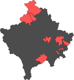
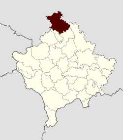 Location of the municipality of Leposavić within Kosovo | ||
| Coordinates: 43°06′N 20°48′E / 43.100°N 20.800°ECoordinates: 43°06′N 20°48′E / 43.100°N 20.800°E | ||
| Country | Kosovo[lower-alpha 1] | |
| District | District of Mitrovica | |
| Settlements | 73 | |
| Government | ||
| • Provisional president | Zoran Todić (GIS) | |
| Area | ||
| • Total | 539 km2 (208 sq mi) | |
| Elevation | 450 m (1,480 ft) | |
| Population (2015) | ||
| • Total | 18,600 | |
| • Density | 35/km2 (89/sq mi) | |
| est. | ||
| Time zone | UTC+1 (CET) | |
| • Summer (DST) | UTC+2 (CEST) | |
| Postal code | 42000 | |
| Area code(s) | +383(0)28 | |
| Car plates | 02 | |
| Climate | Cfb | |
| Website |
www | |
Leposavić (Serbian Cyrillic: Лепосавић, pronounced [lɛ̌pɔsaʋitɕ]), or Leposaviq (or Leposaviç) or Albanik[1] (Albanian: Leposaviqi (or Leposaviçi) or Albaniku), is a town and the northernmost municipality in the Mitrovica District in Kosovo[lower-alpha 1]. As of 2015, it has an estimated population of 18,600 inhabitants.[2] The municipality covers an area of 539 km2 (208 sq mi) which makes it the fifth largest in Kosovo, and consists of the town and 72 villages.
It is a part of North Kosovo, a region with an ethnic Serb majority that functions largely autonomously from the remainder of ethnic Albanian-majority Kosovo. After the 2013 Brussels Agreement, the municipality is expected to become part of the Community of Serb Municipalities.
History
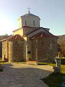
The Sočanica Monastery was founded in the 13th century by King Stefan Milutin. Many of the settlements were mentioned in the Studenica charters of King Stefan Dečanski (r. 1321-1331).
From 1877 to 1913 Leposavić was part of Kosovo vilayet.
Yugoslavia (1918–92)
After the First Balkan War (1912), Kosovo was internationally recognised as a part of Serbia and northern Metohija as a part of Montenegro at the Treaty of London in May 1913. In 1918, the Kingdom of Serbs, Croats and Slovenes, later named Yugoslavia was established by the merging of the Western South Slavic states. Between 1929 and 1941, the region was administratively part of the Zeta Banovina.
Lešak, Belo Brdo, Vračevo, Berberište were incorporated into the Leposavić municipality in 1953.
In the mid–1950s, the Assembly of PR Serbia decided that the Leposavić municipality be ceded to Autonomous Region of Kosovo and Metohija, after requests by the Kosovo leadership.[3] It had up until then been part of the Kraljevo srez, of which the population was wholly Serb.[3] After this, the number of Serbs drastically fell.[3] In 1959, Leposavić was incorporated into the province.[4][5]
Modern
After the NATO bombing of Yugoslavia, the political group Pokret za Leposavić ("Movement for Leposavić") was established, which sought to bring together those committed to cooperation and communication with the international community and the Albanians.[6]
The municipality assembly joined the Association of Serb Municipalities and Settlements of Kosovo and Metohija in 2003, which exercised legislative and executive authority over North Kosovo and other Serb enclaves.
Name
Although historically known as Leposavić in Serbian and Leposaviq in Albanian and being an area of Serbian settlement, since Kosovo's independence, the town has been referred to as Albanik on some maps produced by KFOR.[7] Albanik is preferred over Leposaviq in Kosovo's government documents translated into English.[8]
Settlements
Aside from the town of Leposavić, the municipality includes the following villages:
- Bare
- Belo Brdo
- Beluće
- Berberište
- Bistrica
- Borova
- Borčane
- Brzance
- Vitanoviće
- Vračevo
- Vuča
- Gnježdane
- Gornji Krnjin
- Graničane
- Grkaje
- Guvnište
- Gulije
- Desetak
- Dobrava
- Donje Isevo
- Donji Krnjin
- Dren
- Duboka
- Zabrđe
- Zavrata
- Zemanica
- Zrnosek
- Ibarsko Postenje
- Jarinje
- Jelakce
- Jošanica
- Kajkovo
- Kamenica
- Kijevčiće
- Koporiće
- Kostin Potok
- Košutica
- Košutovo
- Kruševo
- Kruščica
- Kutnje
- Lazine
- Lešak
- Lozno
- Majdevo
- Mekiniće
- Miokoviće
- Mioliće
- Mošnica
- Ostraće
- Plakaonica
- Planinica
- Popovce
- Potkomlje
- Pridvorica
- Rvatska
- Rodelj
- Rucmance
- Seoce
- Slatina
- Sočanica
- Tvrđan
- Trebiće
- Trikose
- Ćirkoviće
- Ulije
- Ceranja
- Crveni
- Crnatovo
- Šaljska Bistrica
Demographics
| Municipal historical population | ||
|---|---|---|
| Year | Pop. | ±% p.a. |
| 1948 | 14,949 | — |
| 1953 | 17,015 | +2.62% |
| 1961 | 19,006 | +1.39% |
| 1971 | 18,044 | −0.52% |
| 1981 | 16,906 | −0.65% |
| 1991 | 16,395 | −0.31% |
| 2011 | 13,773 | −0.87% |
| Source: Division of Kosovo | ||
According to the 2011 estimations by the Government of Kosovo, Leposavić has 4,193 households and 13,773 inhabitants.[9] In 2015 report by OSCE, the population of Leposavić municipality stands at 18,600 inhabitants.[2] Municipality of Leposavić includes town and 72 villages.
Ethnic groups
The majority of Leposavić municipality is composed of Kosovo Serbs with around 18,000 inhabitants (96.4%), while 350 Bosniaks and 270 Kosovo Albanians live in the municipality.[2] Kosovo Albanians live in the three southern villages of Košutovo, Šaljska Bistrica, and Ceranje.
The ethnic composition of the municipality of Leposavić, including IDPs:[2]
| Ethnic group | 1991 est. | 1999 est. | 2015 est. |
|---|---|---|---|
| Serbs | 14,306 | 15,365 | 17,935 |
| Bosniaks | 600 | 940 | 350 |
| Albanians | 1,101 | 902 | 270 |
| Romani, Ashkali | 163 | - | 65 |
| Others | 100 | - | - |
| Total | 16,291 | 17,207 | 18,600 |
Economy
Almost all industrial facilities are closed or work with reduced capacity. The unemployment rate is also high, and it has been considerably increased due to the closing down of most of the Trepča conglomerate facilities. The municipality is rich in natural, infrastructure and management, but current circumstances blocked all the potentials. The municipality adopted the Development Agenda 2006 – 2009, in cooperation with UNOPS and with the support of UNMIK and the Italian Government, which foresees improvement in the local economy. Given the current difficult situation,however, there is not much hope the Agenda will be properly implemented. The municipality, led by a very proactive CEO, pays noteworthy efforts toward identifying and initiating projects ideas.[2]
There are three lead and zinc mines operating on the territory of Leposavić: Belo Brdo, Crepulje and Crnac.
Cultural monuments
The municipality has several monuments protected by the Republic of Serbia as part of the cultural heritage list.
The following Serbian Orthodox churches are located in Leposavić:
- Sočanica Monastery
- Vračevo Monastery
- Church of Cosmas and Damian
- Church of St. Basil of Ostrog
Gallery
 Church of Cosmas and Damian
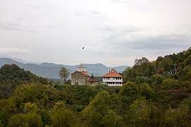 Monastery of Vračevo
 Church of St. Basil of Ostrog
 Church of St. Basil of Ostrog
See also
Notes and references
- Notes
- 1 2 Kosovo is the subject of a territorial dispute between the Republic of Kosovo and the Republic of Serbia. The Republic of Kosovo unilaterally declared independence on 17 February 2008, but Serbia continues to claim it as part of its own sovereign territory. The two governments began to normalise relations in 2013, as part of the Brussels Agreement. Kosovo has received formal recognition as an independent state from 113 out of 193 United Nations member states.
- References
- ↑ MINISTRY OF ECONOMIC DEVELOPMENT. "MINING STRATEGY OF THE REPUBLIC OF KOSOVO 2012 – 2025" (PDF). http://mzhe-ks.net/en. p. 21.
The most important lead and zinc resources and appearances are located in the so called “Metallogenic Trepça strip”, which lies in the northeastern part of Republic of Kosovo, ranging from Albanik (Leposavic) to Gllame (Gjilan). The strip length is over 80km, whereas its average width is around 30km.
line feed character in|title=at position 23 (help); line feed character in|quote=at position 88 (help); External link in|website=(help) - 1 2 3 4 5 "Leposavić". osce.org. OSCE. Retrieved 19 August 2017.
- 1 2 3 Dragoslav Despotović (1993). Raskršća, ili, Autoportret bivšeg narodnog neprijatelja. Nova Iskra. p. 463.
- ↑ Marksistička misao. Marksistički centar Centralnog komiteta Saveza komunista Srbije. 1988. p. 209.
опћина Лепосавић (која је припојена САПК 1959. године)
- ↑ Miloš Macura (1989). Problemi politike obnavljanja stanovništva u Srbiji. Srpska akademija nauka i umetnosti. p. 74.
- ↑ NIN.: Nedeljne informativne novine. Politika. 2001. p. 2.
- ↑ Marc Sommers; Peter Buckland; International Institute for Educational Planning (2004). Parallel worlds: rebuilding the education system in Kosovo. International Institute for Educational Planning.
On the maps produced by KFOR (Kosovo Forces, the collective name for the NATO forces stationed there), diplomacy and compromise are sought: each town in Kosovo has two names: one in Albanian, another in Serbian. Kosovo’s capital is listed both as Prishtinë (Albanian) and Priština (Serbian). Not all of the town names match so closely, however. On some maps, for example, the town of Leposavic (Serbian) is listed not as Leposaviq, the Albanian equivalent, but as ' Albanik', which translates as 'Albanian'. Located in the far north of Kosovo and close to Serbian borders on three sides, Leposavic/Leposaviq/Albanik has historically been an area of Serbian settlement. The politics surrounding 'Albanik' is only one example of the multitude of ways that conflict between Albanians and Serbs in Kosovo continues after the war has passed.
- ↑ MINISTRY OF ECONOMIC DEVELOPMENT. "MINING STRATEGY OF THE REPUBLIC OF KOSOVO 2012–2025" (PDF). http://mzhe-ks.net/en. p. 21. line feed character in
|title=at position 23 (help); External link in|website=(help) - ↑ "ESTIMATION of Kosovo population 2011" (PDF). ask.rks-gov.net. Government of Kosovo. Retrieved 19 August 2017.
Sources
- Благоје Павловић (2003). Насеља и миграције становништва општине Лепосавић. Институт за српску културу Приштина.
- Milka Stojanovic (2009). ИБАРСКИ Колашин - природа и традицијска култура: зборник радова. Centar za Naučna Istraživanja SANU i Univ. u Kragujevcu. ISBN 978-86-81037-24-9.
- Милисав В Лутовац (1954). Ибарски Колашин: антропогеографска испитивања. Издавачко Предузеђе Народне Републике Србије.
External links
| Wikimedia Commons has media related to Leposavić. |
| Ferizaj District |  | |
|---|---|---|
| Gjakova District | ||
| Gjilan District | ||
| Mitrovica District | ||
| Peć District | ||
| Pristina District | ||
| Prizren District | ||
1 Kosovo is the subject of a territorial dispute between the Republic of Kosovo and the Republic of Serbia. The Republic of Kosovo unilaterally declared independence on 17 February 2008, but Serbia continues to claim it as part of its own sovereign territory. The two governments began to normalise relations in 2013, as part of the Brussels Agreement. Kosovo has received formal recognition as an independent state from 113 out of 193 United Nations member states. | ||