Valjevo
| Valjevo Град Ваљево | ||
|---|---|---|
| City | ||
| City of Valjevo | ||
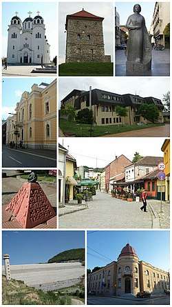 Collage of Valjevo | ||
| ||
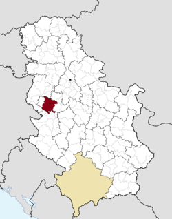 Location of the city of Valjevo within Serbia | ||
| Coordinates: 44°16′N 19°53′E / 44.267°N 19.883°ECoordinates: 44°16′N 19°53′E / 44.267°N 19.883°E | ||
| Country | Serbia | |
| Region | Šumadija and Western Serbia | |
| District | Kolubara | |
| Settlements | 77 | |
| Government | ||
| • Mayor | Stanko Terzić (SPS) | |
| Area[1] | ||
| Area rank | 17th in Serbia | |
| • Urban | 27.44 km2 (10.59 sq mi) | |
| • Administrative | 905 km2 (349 sq mi) | |
| Elevation | 199 m (653 ft) | |
| Population (2011 census)[2] | ||
| • Rank | 15th in Serbia | |
| • Urban | 59,073 | |
| • Urban density | 2,200/km2 (5,600/sq mi) | |
| • Administrative | 90,312 | |
| • Administrative density | 100/km2 (260/sq mi) | |
| Time zone | UTC+1 (CET) | |
| • Summer (DST) | UTC+2 (CEST) | |
| Postal code | 14000 | |
| Area code | +381(0)14 | |
| ISO 3166 code | SRB | |
| Car plates | VA | |
| Website |
www | |

Valjevo (Serbian Cyrillic: Ваљево, pronounced [ʋâːʎeʋo]) is a city and the administrative center of the Kolubara District in western Serbia. According to the 2011 census, the administrative area of Valjevo had 90,312 inhabitants, 59,073 of whom were urban dwellers.
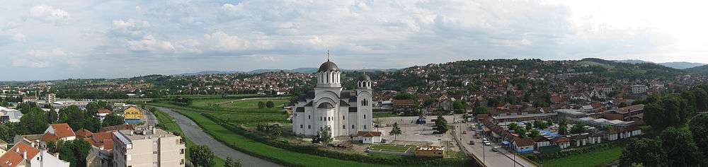
Valjevo occupies an area of 905 square kilometers; its altitude is 185 meters. The city is situated along the river Kolubara, a tributary of the Sava river.
History
In the nearby village of Petnica scientists found the first complete neolithic habitat in Serbia and dated it at 6,000 years old. In Roman times this area was part of the province of Moesia. Valjevo was mentioned for the first time in 1393. It was an important staging post on the trade route that connected Bosnia to Belgrade. Valjevo became significant during the 16th and 17th centuries under stable Ottoman rule.
At the beginning of the 19th century most of the territory of Serbia rapidly transformed. The Serbian revolution began with armed rebellion. In 1804, the local Serb population had rebelled against the Turkish lords and liberated a large part of Serbia. One cause for the revolution was the killing of two prominent Serbian commanders by the Ottoman Turks. The two well-known knights, Ilija Bircanin and Aleksa Nenadovic, were killed in Valjevo on the bridge over the Kolubara.
The settlement's development accelerated further in the 20th century, when Valjevo became an important industrial and cultural center. During the First World War the battle of Kolubara was fought in the immediate vicinity. A large hospital for the wounded was in the town. The city suffered widespread destruction in World War II. At the end of the 20th century it was repeatedly bombed during the NATO attack on Yugoslavia.
Settlements
Apart from the city, Valjevo covers the administrative area which includes the following settlements:
|
|
Demographics
| Historical population | ||
|---|---|---|
| Year | Pop. | ±% p.a. |
| 1948 | 70,459 | — |
| 1953 | 76,104 | +1.55% |
| 1961 | 81,173 | +0.81% |
| 1971 | 88,267 | +0.84% |
| 1981 | 95,449 | +0.79% |
| 1991 | 98,226 | +0.29% |
| 2002 | 96,761 | −0.14% |
| 2011 | 90,312 | −0.76% |
| Source: [3] | ||
According to the 2011 census results, the city of Valjevo has a population of 90,312 inhabitants.
Ethnic groups
The ethnic composition of the city of Valjevo:
| Ethnic group | Population |
|---|---|
| Serbs | 86,423 |
| Roma | 1,413 |
| Montenegrins | 135 |
| Yugoslavs | 105 |
| Macedonians | 80 |
| Croats | 72 |
| Others | 2,084 |
| Total | 90,312 |
Geography
The Valjevo mountain range (Medvednik, Jablanik, Povlen, Maljen, Suvobor), with gently-rolling hills surrounds the town. Divčibare is a plateau in the mountain of Maljen. It has an average altitude of 1000 m. It is 28 km from Valjevo and 110 km from Belgrade.
The canyon of the Gradac River (also the name of a Valjevo suburb) ends in the town centre. The Gradac is one of Europe's cleanest rivers, as evidenced by the presence of otters, which only inhabit unpolluted waters. It abounds in brook trout. Also, the artificial lake Rovni is located 15 kilometers from the center of Valjevo.
 Duke Živojin Mišić statue in Valjevo
 Valjevo in the first half of the 20th century
Amenities
The Valjevo mountain range offers clean air, medicinal herbs, forest fruits and wild game. The vicinity is kept free of industrialisation and the soil is unpolluted, so the food grown there is healthy. Hunting and fishing in the mountain rivers is common. The air-spa of Divčibare offers rest and recreation.
Vrujci Spa has mud baths for rheumatic diseases, as well as a hotel and sports complex with swimming pools.
Old water mills are found in the thirteen square kilometers natural reserve.
In Petnica, 5 km away from Valjevo, the Petnica Science Center supports young researchers. It has outdoor swimming pools with minor sports facilities, as well as lake Pocibrava, a recreational area.
The Nenadović Tower (Кула Ненадовића), originally an armory built by Jakov Nenadović and his son Jevrem in spring 1813,[4] is adjacent to the road to Šabac, at the edge of Kličevac hill. The construction material was stone from an older Vitković tower. Later, the Ottomans turned it into a prison.[5]
Surroundings
The village of Brankovina is situated near Valjevo and is known as the home of the notable Nenadović family. The sights of Brankovina are encompassed in a cultural and historical complex, which includes: the Church of Saint Archangel, Archpriest’s school, Desanka's school, Old Courtroom, the Sleeping Outbuilding of the Nenadović family, the graves of the Nenadović family and Desanka Maksimović, as well as old “sobrašica” summer houses in the exquisitely beautiful Brankovina church yard.
Several ancient monasteries are located in the area surrounding of Valjevo, including Pustinja, Lelić, and Ćelije. The sites on which the current monasteries stand have been used for religious purposes since the 10th century, although the current church buildings date to between 14th and 17th centuries. Pustinja Monastery is located in the cleft of a remote mountainous valley and contains rare Serbian medieval frescoes. Excavations have shown that the current church was built on the foundations of a much older church. Parts of the foundation and an unidentified tomb, much older than the church itself, were discovered. The church is only accessible by a steep path. However, despite its inaccessibility, the Turks managed to damage the monastery more than once. It was damaged in 1683 during the invasion of Turkish army to Vienna. Pustinja is today an active female monastery.
Climate
The climate in this area has mild differences between highs and lows, with adequate rainfall year-round. The Köppen Climate Classification subtype for this climate is "Cfb" (Marine West Coast Climate).[6]
| Climate data for Valjevo (1981–2010, extremes 1961–2010) | |||||||||||||
|---|---|---|---|---|---|---|---|---|---|---|---|---|---|
| Month | Jan | Feb | Mar | Apr | May | Jun | Jul | Aug | Sep | Oct | Nov | Dec | Year |
| Record high °C (°F) | 23.3 (73.9) |
25.4 (77.7) |
30.0 (86) |
31.8 (89.2) |
35.4 (95.7) |
37.7 (99.9) |
42.4 (108.3) |
40.8 (105.4) |
38.1 (100.6) |
32.7 (90.9) |
28.3 (82.9) |
23.8 (74.8) |
42.4 (108.3) |
| Average high °C (°F) | 5.3 (41.5) |
7.4 (45.3) |
12.7 (54.9) |
17.7 (63.9) |
22.9 (73.2) |
25.6 (78.1) |
28.0 (82.4) |
28.1 (82.6) |
23.6 (74.5) |
18.6 (65.5) |
11.8 (53.2) |
6.3 (43.3) |
17.3 (63.1) |
| Daily mean °C (°F) | 0.6 (33.1) |
2.0 (35.6) |
6.6 (43.9) |
11.6 (52.9) |
16.8 (62.2) |
19.9 (67.8) |
21.9 (71.4) |
21.4 (70.5) |
16.8 (62.2) |
11.7 (53.1) |
6.1 (43) |
1.9 (35.4) |
11.4 (52.5) |
| Average low °C (°F) | −3.2 (26.2) |
−2.3 (27.9) |
1.5 (34.7) |
5.8 (42.4) |
10.6 (51.1) |
13.9 (57) |
15.6 (60.1) |
15.3 (59.5) |
11.1 (52) |
6.4 (43.5) |
1.7 (35.1) |
−1.7 (28.9) |
6.2 (43.2) |
| Record low °C (°F) | −28.4 (−19.1) |
−23.3 (−9.9) |
−16.3 (2.7) |
−7.0 (19.4) |
−1.4 (29.5) |
3.4 (38.1) |
5.9 (42.6) |
3.2 (37.8) |
−2.4 (27.7) |
−6.1 (21) |
−15.3 (4.5) |
−21.0 (−5.8) |
−28.4 (−19.1) |
| Average precipitation mm (inches) | 49.9 (1.965) |
44.6 (1.756) |
57.9 (2.28) |
59.9 (2.358) |
72.1 (2.839) |
110.2 (4.339) |
71.0 (2.795) |
70.7 (2.783) |
65.3 (2.571) |
62.9 (2.476) |
62.7 (2.469) |
60.6 (2.386) |
787.7 (31.012) |
| Average precipitation days (≥ 0.1 mm) | 14 | 13 | 13 | 13 | 14 | 14 | 10 | 10 | 10 | 10 | 12 | 15 | 146 |
| Average snowy days | 8 | 8 | 4 | 1 | 0 | 0 | 0 | 0 | 0 | 0 | 3 | 7 | 32 |
| Average relative humidity (%) | 82 | 76 | 70 | 68 | 68 | 70 | 67 | 69 | 74 | 78 | 80 | 82 | 74 |
| Mean monthly sunshine hours | 72.9 | 93.2 | 143.3 | 172.8 | 231.9 | 250.6 | 290.2 | 267.9 | 200.9 | 149.6 | 97.6 | 61.4 | 2,032.2 |
| Source: Republic Hydrometeorological Service of Serbia[7] | |||||||||||||
Society and culture
Cultural institutions
The most important cultural institutions are the National Museum, under whose auspices are the Museum of the First and Second Serbian Uprisings and displays in Brankovina. Other institutions include the Institute for Protection of Cultural Monuments, the Historical Archive, the Town Library. The Cultural Centre has a well-equipped stage and an auditorium with 630 seats. The Youth Centre has "Gallery 34" for exhibitions and forums. The Serbian Language and Culture Workshop offers classes in Serbian for foreigners.
Valjevo has two elite art galleries. The Modern Gallery has a permanent display of works of the Academician Ljuba Popović (1953-63 period), a collection of works presented by exhibitors and a concept of representing fantastic painting after the model of the famous "Mediala". The International Art Studio "Radovan Mića Trnavac" exhibits foreign painters of different styles.
The Cultural and Artistic Society "Abrašević" has a renowned choir, along with folk music and drama ensembles. Theatrical performances are given by the private theatre "Mala scena" and the Drama Studio of Valjevo Grammar School.
The Jazz Fest is accompanied by summer literary talks in the Library Yard. Desanka’s May Talks discuss literary topics, where the Desanka Maksimović Foundation grants an annual poetry award.
Tešnjar
Tešnjar is one of the oldest paved streets in Valjevo. It is used for films based in the past and is one of the places that makes the beautiful town unique.
Economy
The main economic activity in the second half of the 20th century was the arms manufacturing firm Krušik Valjevo, which returned to production after the wars. The Valjevo economy is characterized by small, private companies working in metallurgy, food production and textiles. Austrian company Austrotherm GmbH, Italian company Golden Lady and Slovenian company Gorenje have built production facilities in Valjevo. Another notable domestic company is Valjevska Pivara, founded in 1860.
The following table gives a preview of total number of employed people per their core activity (as of 2016):[8]
| Activity | Total |
|---|---|
| Agriculture, forestry and fishing | 444 |
| Mining | 105 |
| Processing industry | 8,621 |
| Distribution of power, gas and water | 348 |
| Distribution of water and water waste management | 476 |
| Construction | 1,567 |
| Wholesale and retail, repair | 3,610 |
| Traffic, storage and communication | 1,128 |
| Hotels and restaurants | 778 |
| Media and telecommunications | 273 |
| Finance and insurance | 424 |
| Property stock and charter | 43 |
| Professional, scientific, innovative and technical activities | 727 |
| Administrative and other services | 436 |
| Administration and social assurance | 1,589 |
| Education | 1,792 |
| Healthcare and social work | 1,721 |
| Art, leisure and recreation | 262 |
| Other services | 611 |
| Total | 24,956 |
Politics
Seats in the city parliament won in the 2016 local elections:[9]
| Party | Seats | |||
|---|---|---|---|---|
| Serbian Progressive Party | 26 | |||
| Socialist Party of Serbia | 18 | |||
| Democratic Party | 4 | |||
| Enough is Enough | 3 | |||
| Source: Local Elections in Serbia 2016[9] | ||||
Gallery
 A view of the city from the west. River Kolubara and city wheat silo can be seen
 Petnica cave
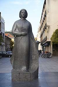 Desanka Maksimović monument
 Nenadović Tower from 1813
 Cave Park
 Tešnjar, old urban settlement in Valjevo
 Gradac River near Valjevo

Notable people
Serbia's best-known female poet, Desanka Maksimović, was born in nearby Rabrovica and spent her childhood and completed primary school in Brankovina.
Serbia's best-known CPA Accountant and current President of Instant Technology, Mirjana Schultz was born in this region.
Serbian famous singer, composer, songwriter, multi-instrumentalist, and producer, Željko Joksimović grew up in Valjevo
Serbian basketball player and one of the best European basketball players, Miloš Teodosić, was born in this city.
Nenadović family
This family produced leaders of the First Serbian Uprising, ministers of the first Serbian government, spiritual leaders and travel writers. Some members are: Duke Aleksa, Archpriest Mateja Nenadović, Duke Jakov Nenadović, Sima and Jevrem, writer Čika Ljuba Nenadović, and Persida Karađorđević, the mother of King Peter I of Serbia.
International cooperation
Valjevo has official sister cities:
| Country | City | Date | |
|---|---|---|---|
| Slovakia | Prievidza, Trenčín Region | ||
| Germany | Pfaffenhofen, Bavaria | ||
| Netherlands | Sittard, Limburg |
See also
References
- ↑ "Municipalities of Serbia, 2006". Statistical Office of Serbia. Retrieved 2010-11-28.
- ↑ "2011 Census of Population, Households and Dwellings in the Republic of Serbia: Comparative Overview of the Number of Population in 1948, 1953, 1961, 1971, 1981, 1991, 2002 and 2011, Data by settlements" (PDF). Statistical Office of Republic Of Serbia, Belgrade. 2014. ISBN 978-86-6161-109-4. Retrieved 2014-06-27.
- ↑ "2011 Census of Population, Households and Dwellings in the Republic of Serbia" (PDF). stat.gov.rs. Statistical Office of the Republic of Serbia. Retrieved 11 January 2017.
- ↑ "Kula Nenadovića" (in Serbian). Valjevozavas.net. Retrieved 18 May 2012.
Kula Nenadovića je svakako simbol grada Valjeva. Podignuta je u proleće 1813. godine ...
- ↑ Subotić, Vojislav (2006). Memorijali oslobodilačkih ratova Srbije, Book 1, Volume 1. Vlada Republike Srbije, Ministarstvo rada, zapošljavanja i socijalne politike. p. 97. Retrieved 18 May 2012.
Kula Nenadovica (Nenadovic's Tower) ... was built at Jakob Nenadovic's command in 1813. He was Minister for Private Affairs. It served for military purposes. Turks used it as a prison later
- ↑ "Valjevo, Serbia Köppen Climate Classification (Weatherbase)". Weatherbase.
- ↑ "Monthly and annual means, maximum and minimum values of meteorological elements for the period 1981–2010" (in Serbian). Republic Hydrometeorological Service of Serbia. Retrieved February 25, 2017.
- ↑ "ОПШТИНЕ И РЕГИОНИ У РЕПУБЛИЦИ СРБИЈИ, 2017" (PDF). stat.gov.rs (in Serbian). Statistical Office of the Republic of Serbia. Retrieved 18 February 2018.
- 1 2 Vujanac, Caca. "Valjevo je glasalo". www.vamedia.info.
External links
| Wikimedia Commons has media related to Valjevo. |
| Wikisource has the text of the 1911 Encyclopædia Britannica article Valyevo. |
- City of Valjevo
- Valjevskaposla.info - The best city news portal
- Valjevo online
- Serbian Language and Culture Workshop


| Authority control |
|---|