Bela Palanka
| Bela Palanka Бела Паланка | ||
|---|---|---|
| Town and municipality | ||
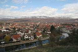 View from heights | ||
| ||
 Location of the municipality of Bela Palanka within Serbia | ||
| Coordinates: 43°13′N 22°19′E / 43.217°N 22.317°ECoordinates: 43°13′N 22°19′E / 43.217°N 22.317°E | ||
| Country |
| |
| Region | Southern and Eastern Serbia | |
| District | Pirot | |
| Settlements | 46 | |
| Government | ||
| • Mayor | Goran Miljković (SNS) | |
| Area[1] | ||
| • Urban | 8.28 km2 (3.20 sq mi) | |
| • Municipality | 551 km2 (213 sq mi) | |
| Elevation | 394 m (1,293 ft) | |
| Population (2011 census)[2] | ||
| • Town | 8,143 | |
| • Town density | 980/km2 (2,500/sq mi) | |
| • Municipality | 12,126 | |
| • Municipality density | 22/km2 (57/sq mi) | |
| Time zone | UTC+1 (CET) | |
| • Summer (DST) | UTC+2 (CEST) | |
| Postal code | 18310 | |
| Area code | +381(0)18 | |
| Car plates | PI | |
| Website |
www | |

Bela Palanka (Serbian Cyrillic: Бела Паланка, pronounced [bɛ̂ːlaː pǎlaːŋka]) is a town and municipality located in the Pirot District of southeastern Serbia. According to the 2011 census, the population of the town is 8,143, and the population of the municipality is 12,126. In ancient times, the town was known as Remesiana. The name Bela Palanka means 'white town'.
Geography
Bela Palanka is a small town in the southeast of the country and is surrounded by countryside and mountains. The town is accessible from the nearby city of Niš by the Niš Express buses that run from Niš to Pirot, Babušnica, Dimitrovgrad, and Sofia.
Climate
Bela Palanka has an oceanic climate (Köppen climate classification: Cfb), that's very close to a humid continental climate (Köppen climate classification: Dfb).
| Climate data for Bela Palanka | |||||||||||||
|---|---|---|---|---|---|---|---|---|---|---|---|---|---|
| Month | Jan | Feb | Mar | Apr | May | Jun | Jul | Aug | Sep | Oct | Nov | Dec | Year |
| Average high °C (°F) | 3.6 (38.5) |
6.4 (43.5) |
12.1 (53.8) |
16.8 (62.2) |
21.6 (70.9) |
25.3 (77.5) |
27.6 (81.7) |
27.9 (82.2) |
24.2 (75.6) |
18.1 (64.6) |
9.7 (49.5) |
4.9 (40.8) |
16.5 (61.7) |
| Daily mean °C (°F) | 0.1 (32.2) |
2.5 (36.5) |
6.9 (44.4) |
11.1 (52) |
15.7 (60.3) |
19.1 (66.4) |
20.8 (69.4) |
20.9 (69.6) |
17.3 (63.1) |
12.4 (54.3) |
5.8 (42.4) |
1.8 (35.2) |
11.2 (52.2) |
| Average low °C (°F) | −3.3 (26.1) |
−1.4 (29.5) |
1.7 (35.1) |
5.4 (41.7) |
9.8 (49.6) |
12.9 (55.2) |
14.1 (57.4) |
13.9 (57) |
10.5 (50.9) |
6.7 (44.1) |
2.0 (35.6) |
−1.2 (29.8) |
5.9 (42.7) |
| Average precipitation mm (inches) | 40 (1.57) |
39 (1.54) |
41 (1.61) |
49 (1.93) |
67 (2.64) |
65 (2.56) |
49 (1.93) |
41 (1.61) |
42 (1.65) |
42 (1.65) |
55 (2.17) |
52 (2.05) |
582 (22.91) |
| Source: Climate-Data.org [3] | |||||||||||||
History
The town was originally settled by the Dacians and was known under the ancient name of Aiadava or Aeadaba. Thracians inhabited the area until their assimilation into contemporary ethnic groups in the area.
After the Romans conquered Moesia in 75 BC, the new castrum (imperial domain with estates) and municipium was known initially as Ulpianorum and then Remesiana[4] (Moesi) and stood along the Via Militaris between Naissus and Serdica.
Emperor Justinian had following strongholds in the district of Remesiana:
|
Brittura Subaras Lamponiana Stronges Dalmatas Primiana Phrerraria Topera Tomes Cuas Tzertzenutzas Stens Aeadaba Destreba Pretzouries Cumudeba Deurias Lutzolo Rhepordenes Spelonca Scumbro Briparo Tulcoburgo Longiana Lupophantana Dardapara Burdomina Grinciapana Graecus Drasimarca |
The patron saint of Romania, Nicetas of Remesiana, was a 4th-century bishop at Remesiana. Peter the Hermit was defeated by the Byzantines in the north and regrouped at an evacuated Bela Palanka, gathering the harvest before heading to Constantinople.[5]
Excavations include well-preserved castrum dating to 4th century and a hoard of 260 coins minted during the rule of Constantine I, Theodosius I, Tiberius Claudius Nero (3rd century AD).[6] During the 1096 People's Crusade the town, left abandoned by its inhabitants, was briefly occupied by the pilgrims led by Peter the Hermit, Walter of Breteuil and Rainald of Breis.
From 1929 to 1941, Bela Palanka was part of the Morava Banovina of the Kingdom of Yugoslavia.
Settlements
Aside from the town of Bela Palanka, the municipality consists of the following villages:
Demographics
| Historical population | ||
|---|---|---|
| Year | Pop. | ±% p.a. |
| 1948 | 29,641 | — |
| 1953 | 28,756 | −0.60% |
| 1961 | 24,982 | −1.74% |
| 1971 | 21,325 | −1.57% |
| 1981 | 18,744 | −1.28% |
| 1991 | 16,447 | −1.30% |
| 2002 | 14,381 | −1.21% |
| 2011 | 12,126 | −1.88% |
| Source: [7] | ||
According to the 2011 census results, the municipality has 12,126 inhabitants.
Ethnic groups
The ethnic composition of the municipality:
| Ethnic group | Population |
|---|---|
| Serbs | 10,395 |
| Romani | 1,418 |
| Muslims | 10 |
| Macedonians | 8 |
| Bulgarians | 8 |
| Others | 257 |
| Total | 12,126 |
Economy
The following table gives a preview of total number of employed people per their core activity (as of 2016):[8]
| Activity | Total |
|---|---|
| Agriculture, forestry and fishing | 17 |
| Mining | 48 |
| Processing industry | 354 |
| Distribution of power, gas and water | 19 |
| Distribution of water and water waste management | 69 |
| Construction | 55 |
| Wholesale and retail, repair | 223 |
| Traffic, storage and communication | 81 |
| Hotels and restaurants | 81 |
| Media and telecommunications | 30 |
| Finance and insurance | 12 |
| Property stock and charter | - |
| Professional, scientific, innovative and technical activities | 48 |
| Administrative and other services | 66 |
| Administration and social assurance | 143 |
| Education | 159 |
| Healthcare and social work | 173 |
| Art, leisure and recreation | 54 |
| Other services | 32 |
| Total | 1,662 |
Gallery
 Bela Palanka by night
 Fountain
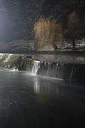
 Spring
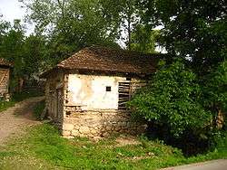
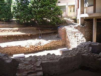 Basilica Apse under excavation in Remesiana
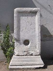 3rd century Septimius Severus monument in Bela Palanka.
 Rajko Mitić Monument
See also
References
- ↑ "Municipalities of Serbia, 2006". Statistical Office of Serbia. Retrieved 2010-11-28.
- ↑ "2011 Census of Population, Households and Dwellings in the Republic of Serbia: Comparative Overview of the Number of Population in 1948, 1953, 1961, 1971, 1981, 1991, 2002 and 2011, Data by settlements" (PDF). Statistical Office of Republic Of Serbia, Belgrade. 2014. ISBN 978-86-6161-109-4. Retrieved 2014-06-27.
- ↑ "Climate: Bela Palanka, Serbia". Climate-Data.org. Retrieved 16 February 2018.
- ↑ "Archived copy". Archived from the original on 2011-07-15. Retrieved 2011-01-23.
- ↑ God's war: a new history of the Crusades-Christopher Tyerman 2006
- ↑ Ancient diseases: the elements of palaeopathology-Srboljub Živanović 1982
- ↑ "2011 Census of Population, Households and Dwellings in the Republic of Serbia" (PDF). stat.gov.rs. Statistical Office of the Republic of Serbia. Archived from the original (PDF) on 14 July 2014. Retrieved 6 March 2017.
- ↑ "ОПШТИНЕ И РЕГИОНИ У РЕПУБЛИЦИ СРБИЈИ, 2017" (PDF). stat.gov.rs (in Serbian). Statistical Office of the Republic of Serbia. Retrieved 17 February 2017.
External links
| Wikimedia Commons has media related to Bela Palanka. |
