Donji Tavankut
| Donji Tavankut Доњи Таванкут | |
|---|---|
| Village | |
| Country |
|
| Province |
|
| Time zone | UTC+1 (CET) |
| • Summer (DST) | UTC+2 (CEST) |
Donji Tavankut (Serbian Cyrillic: Доњи Таванкут), also known simply as Tavankut (Таванкут), is a village located some 16 km west of Subotica, Serbia. It is located in the Subotica municipality, in the North Bačka District of Serbia, in the Autonomous Province of Vojvodina.
Name
In Serbian the village is known as Donji Tavankut or Доњи Таванкут, in Croatian as Donji Tavankut, in Bunjevac as Donji Tavankut, and in Hungarian as Alsótavankút.
Population
1991
According to the 1991 Census, Donji Tavankut had a population of 2,710 inhabitants, including:
- Bunjevci = 989
- Croats = 877
- Yugoslavs = 600
- Hungarians = 97
- Serbs = 71
2002
According to the 2002 Census, Donji Tavankut has a population of 2,631 inhabitants, including:
- Croats = 1,234 (46.90%)
- Bunjevci = 787 (29.91%)
- Serbs = 190 (7.22%)
- Yugoslavs = 137 (5.21%)
- Hungarians = 117 (4.45%)
Historical population
- 1981: 2,719
- 1991: 2,710
- 2002: 2,631
Geography
Tavankut includes several relatively separate smaller communities ("kraj"), such as Čikerija (or Čekerija), Sajc (or Nemirna ravnica), Vuković Kraj, Marinkić Kraj, Zlatni Kraj, Skenderovo, Dikanovac, Kaponja (or Kapunja).
Features
It has two railway stations (Donji Tavankut and Skenderovo) on the railroad from Subotica to Sombor (and further to Bezdan, Apatin or Erdut). It also has a primary school (”Matija Gubec”), and football (soccer) club OFK Tavankut. The main pubs/cafés in Tavankut are: Tango, Teens, Jugoslavija (closd down), and Tri muve.
Rv unsourced section.
See also
References
- Slobodan Ćurčić, Broj stanovnika Vojvodine, Novi Sad, 1996.
External links
Cities, towns and villages in the North Bačka District | ||
|---|---|---|
| Subotica | 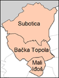 | |
| Bačka Topola | ||
| Mali Iđoš | ||
(*) bold are municipalities or cities | ||