Tutin, Serbia
| Tutin Тутин | ||
|---|---|---|
| Town and municipality | ||
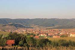 Panorama of Tutin | ||
| ||
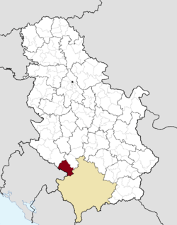 Location of the municipality of Tutin within Serbia | ||
| Coordinates: 42°59′N 20°20′E / 42.983°N 20.333°ECoordinates: 42°59′N 20°20′E / 42.983°N 20.333°E | ||
| Country |
| |
| Region | Šumadija and Western Serbia | |
| District | Raška | |
| Settlements | 93 | |
| Government | ||
| • Mayor | Kenan Hot (SDA) | |
| Area[1] | ||
| • Town | 2.94 km2 (1.14 sq mi) | |
| • Municipality | 743 km2 (287 sq mi) | |
| Elevation | 867 m (2,844 ft) | |
| Population (2011 census)[2] | ||
| • Town | 10,094 | |
| • Town density | 3,400/km2 (8,900/sq mi) | |
| • Municipality | 31,155 | |
| • Municipality density | 42/km2 (110/sq mi) | |
| Time zone | UTC+1 (CET) | |
| • Summer (DST) | UTC+2 (CEST) | |
| Postal code | 36320 | |
| Area code | +381(0)20 | |
| Car plates | TT | |
| Website |
www | |

Tutin (Serbian Cyrillic: Тутин) is a town and municipality located in the Raška District of the southwestern Serbia. According to a 2011 census, the municipality of Tutin has a population of 31,155 people.
History
The former name of Tutin was Donja Dimitrova. At first, it was only a caravan station, while in the beginning of the 19th century it became a settlement with guardian tower and a mosque. In 1831, the army of Bosnian Husein-beg Gradaščević was stationed in it. Name Tutin firstly appeared in 1868 in work of English travelers. According to that work, Tutin had only 7 houses of which 6 belonged to the Bosniak family Hamzagić and one was Serb. Until 1912, Tutin was small settlement with 20 houses. In the 20th century, the settlement was greatly developed: public buildings, a health station, a school and shops were built. It was occupied by Italy between 1941-1943 and Germany between 1943-1944. During the occupiation, it was part of Protectorate of Albania.
It is the first municipality in Serbia that has renewable wind power.[3]
Climate
Tutin has a humid continental climate (Köppen climate classification: Dfb).
| Climate data for Tutin | |||||||||||||
|---|---|---|---|---|---|---|---|---|---|---|---|---|---|
| Month | Jan | Feb | Mar | Apr | May | Jun | Jul | Aug | Sep | Oct | Nov | Dec | Year |
| Average high °C (°F) | 1.3 (34.3) |
3.8 (38.8) |
8.8 (47.8) |
13.0 (55.4) |
17.7 (63.9) |
21.2 (70.2) |
23.6 (74.5) |
23.8 (74.8) |
20.3 (68.5) |
14.5 (58.1) |
7.2 (45) |
2.7 (36.9) |
13.2 (55.7) |
| Daily mean °C (°F) | −1.9 (28.6) |
0.0 (32) |
4.4 (39.9) |
8.2 (46.8) |
12.6 (54.7) |
16.0 (60.8) |
18.0 (64.4) |
18.1 (64.6) |
14.8 (58.6) |
9.8 (49.6) |
3.8 (38.8) |
−0.2 (31.6) |
8.6 (47.5) |
| Average low °C (°F) | −5.1 (22.8) |
−3.7 (25.3) |
0.0 (32) |
3.4 (38.1) |
7.6 (45.7) |
10.8 (51.4) |
12.5 (54.5) |
12.4 (54.3) |
9.4 (48.9) |
5.2 (41.4) |
0.4 (32.7) |
−3.1 (26.4) |
4.1 (39.5) |
| Average precipitation mm (inches) | 82 (3.23) |
72 (2.83) |
75 (2.95) |
82 (3.23) |
98 (3.86) |
82 (3.23) |
72 (2.83) |
67 (2.64) |
77 (3.03) |
88 (3.46) |
105 (4.13) |
94 (3.7) |
994 (39.12) |
| Source: Climate-Data.org [4] | |||||||||||||
Demographics
| Historical population | ||
|---|---|---|
| Year | Pop. | ±% p.a. |
| 1948 | 24,662 | — |
| 1953 | 27,963 | +2.54% |
| 1961 | 29,959 | +0.87% |
| 1971 | 29,944 | −0.01% |
| 1981 | 32,779 | +0.91% |
| 1991 | 34,631 | +0.55% |
| 2002 | 30,054 | −1.28% |
| 2011 | 31,155 | +0.40% |
| Source: [5] | ||
According to the last official census done in 2011, the Municipality of Tutin has 31,155 inhabitants. Population that lives in urban areas comprises 32.4% of the municipality’s total population. Depopulation is typical for villages because of the migrations to urban and other areas. Population density on the territory of the municipality is 41.99 inhabitants per square kilometer.
Ethnic groups
Most of Tutin’s population are Bosniaks (90.0%), followed by Muslims and Serbs. Ethnic composition of the municipality:
| Ethnic group | Population 1991 |
Population 2002 |
Population 2011 |
|---|---|---|---|
| Bosniaks | - | 28,320 | 28,041 |
| Muslims | 32,671 | 222 | 1,092 |
| Serbs | 1,503 | 1,298 | 1,090 |
| Romani | - | - | 67 |
| Gorani | - | - | 55 |
| Others | 457 | 214 | 810 |
| Total | 34,631 | 30,054 | 31,155 |
Note: Most of those who in 1991 census declared themselves as Muslims by nationality, in the next census in 2002 declared themselves as Bosniaks, while the smaller number of them still declare themselves as Muslims by nationality.
Economy
The following table gives a preview of total number of employed people per their core activity (as of 2016):[6]
| Activity | Total |
|---|---|
| Agriculture, forestry and fishing | 98 |
| Mining | 48 |
| Processing industry | 863 |
| Distribution of power, gas and water | 28 |
| Distribution of water and water waste management | 48 |
| Construction | 187 |
| Wholesale and retail, repair | 429 |
| Traffic, storage and communication | 111 |
| Hotels and restaurants | 114 |
| Media and telecommunications | 23 |
| Finance and insurance | 15 |
| Property stock and charter | - |
| Professional, scientific, innovative and technical activities | 86 |
| Administrative and other services | 23 |
| Administration and social assurance | 330 |
| Education | 691 |
| Healthcare and social work | 438 |
| Art, leisure and recreation | 44 |
| Other services | 197 |
| Total | 3,773 |
Notable people
- Mensur Suljović (born 1972), Austrian darts player
- Saffet Sancaklı (born 1966), Turkish footballer, politician
International relations
Twin towns – Sister cities
Tutin is twinned with:
See also
References
- ↑ "Municipalities of Serbia, 2006". Statistical Office of Serbia. Retrieved 2010-11-28.
- ↑ "2011 Census of Population, Households and Dwellings in the Republic of Serbia: Comparative Overview of the Number of Population in 1948, 1953, 1961, 1971, 1981, 1991, 2002 and 2011, Data by settlements" (PDF). Statistical Office of Republic Of Serbia, Belgrade. 2014. ISBN 978-86-6161-109-4. Retrieved 2014-06-27.
- ↑ "Biz - Vesti - Prva srpska vetrenjača u Tutinu". B92. Retrieved 2012-01-30.
- ↑ "Climate: Tutin, Serbia". Climate-Data.org. Retrieved January 10, 2018.
- ↑ "2011 Census of Population, Households and Dwellings in the Republic of Serbia" (PDF). stat.gov.rs. Statistical Office of the Republic of Serbia. Retrieved 11 January 2017.
- ↑ "ОПШТИНЕ И РЕГИОНИ У РЕПУБЛИЦИ СРБИЈИ, 2017" (PDF). stat.gov.rs (in Serbian). Statistical Office of the Republic of Serbia. Retrieved 20 February 2018.
- ↑ "Mostar Gradovi prijatelji" [Mostar Twin Towns]. Grad Mostar [Mostar Official City Website] (in Macedonian). Archived from the original on 2013-10-30. Retrieved 2013-12-19.
External links
| Wikimedia Commons has media related to Tutin. |


