Priboj
| Priboj Прибој | ||
|---|---|---|
| Town and municipality | ||
   | ||
| ||
 Location of the municipality of Priboj within Serbia | ||
| Coordinates: 43°36′N 19°32′E / 43.600°N 19.533°ECoordinates: 43°36′N 19°32′E / 43.600°N 19.533°E | ||
| Country |
| |
| Region | Šumadija and Western Serbia | |
| District | Zlatibor | |
| Settlements | 33 | |
| Government | ||
| • Mayor | Lazar Rvović | |
| Area[1] | ||
| • Town | 6.07 km2 (2.34 sq mi) | |
| • Municipality | 553 km2 (214 sq mi) | |
| Elevation | 882 m (2,894 ft) | |
| Highest elevation | 1,500 m (4,900 ft) | |
| Lowest elevation | 392 m (1,286 ft) | |
| Population (2011 census)[2] | ||
| • Town | 14,920 | |
| • Town density | 2,500/km2 (6,400/sq mi) | |
| • Municipality | 27,133 | |
| • Municipality density | 49/km2 (130/sq mi) | |
| Time zone | UTC+1 (CET) | |
| • Summer (DST) | UTC+2 (CEST) | |
| Postal code | 31330 | |
| Area code | +381(0)33 | |
| Car plates | PB | |
| Website |
www | |
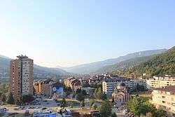
Priboj (Serbian Cyrillic: Прибој, pronounced [prǐːbɔj]) is a town and municipality located in the Zlatibor District of southwestern Serbia. The population of the town is 14,920, while the population of the municipality is 27,133.
Geography
The municipality of Priboj is located between municipality of Čajetina in the north, municipality of Nova Varoš in the east, municipality of Prijepolje in the south-east, border with Montenegro in the south-west, and border with Bosnia and Herzegovina in the north-west. A Bosnian-Herzegovinian exclave (Sastavci village) is surrounded by the Priboj municipality.
The town of Priboj lies on the river Lim. It is 5 km away from Uvac, a smaller river that is the border between Bosnia and Herzegovina and Serbia.
Climate
Priboj has an oceanic climate (Köppen climate classification: Cfb).
| Climate data for Priboj | |||||||||||||
|---|---|---|---|---|---|---|---|---|---|---|---|---|---|
| Month | Jan | Feb | Mar | Apr | May | Jun | Jul | Aug | Sep | Oct | Nov | Dec | Year |
| Average high °C (°F) | 2.8 (37) |
5.9 (42.6) |
10.9 (51.6) |
14.5 (58.1) |
19.5 (67.1) |
22.9 (73.2) |
25.3 (77.5) |
25.6 (78.1) |
22.2 (72) |
16.9 (62.4) |
9.2 (48.6) |
4.4 (39.9) |
15 (59) |
| Daily mean °C (°F) | −0.9 (30.4) |
1.6 (34.9) |
5.8 (42.4) |
9.2 (48.6) |
13.9 (57) |
17.2 (63) |
19.2 (66.6) |
19.2 (66.6) |
16.0 (60.8) |
11.4 (52.5) |
5.3 (41.5) |
1.1 (34) |
9.9 (49.9) |
| Average low °C (°F) | −4.6 (23.7) |
−2.6 (27.3) |
0.8 (33.4) |
4.0 (39.2) |
8.4 (47.1) |
11.6 (52.9) |
13.2 (55.8) |
12.9 (55.2) |
9.8 (49.6) |
6.0 (42.8) |
1.4 (34.5) |
−2.2 (28) |
4.9 (40.8) |
| Average precipitation mm (inches) | 80 (3.15) |
72 (2.83) |
71 (2.8) |
83 (3.27) |
97 (3.82) |
92 (3.62) |
79 (3.11) |
71 (2.8) |
83 (3.27) |
89 (3.5) |
103 (4.06) |
94 (3.7) |
1,014 (39.93) |
| Source: Climate-Data.org [3] | |||||||||||||
History
During the medieval times, the region around modern city of Priboj in the lower valley of the Lim river was called "Dabar" and it belonged to the medieval Serbia until the Turkish invasion in the middle of 15th century. Between 1459 and 1463, the town of Priboj was first mentioned in written documents of the Ottoman Empire.[4]
Settlements
Aside from the town of Priboj, the municipality includes the following settlements:
- Banja
- Batkovići
- Brezna
- Bučje
- Dobrilovići
- Živinice
- Zabrđe
- Zabrnjica
- Zagradina
- Zaostro
- Jelača
- Kalafati
- Kaluđerovići
- Kasidoli
- Kratovo
- Krnjača
- Kukurovići
- Mažići
- Miliješ
- Plašće
- Požegrmac
- Pribojska Goleša
- Pribojske Čelice
- Rača
- Ritošići
- Sjeverin
- Sočice
- Strmac
- Hercegovačka Goleša
- Crnugovići
- Crnuzi
- Čitluk
- Akmačići
Demographics
| Historical population | ||
|---|---|---|
| Year | Pop. | ±% p.a. |
| 1948 | 17,989 | — |
| 1953 | 20,784 | +2.93% |
| 1961 | 26,147 | +2.91% |
| 1971 | 32,548 | +2.21% |
| 1981 | 35,200 | +0.79% |
| 1991 | 35,951 | +0.21% |
| 2002 | 30,377 | −1.52% |
| 2011 | 27,133 | −1.25% |
| Source: [5] | ||
According to the last official census done in 2011, the Municipality of Priboj has 27,133 inhabitants with 49.4% of the municipality’s population living in the urban areas.
Ethnic groups
In 1991, the population of the Priboj municipality numbered 35,951 people, and was composed of Serbs (67.26%), Muslims (30.39%) and others. Most of those who in 1991 census declared themselves as Muslims by nationality, in the next census in 2002 declared themselves as Bosniaks, while the smaller number of them still declare themselves as Muslims by nationality.
In 2002, the population of the Priboj town numbered 19,564 people, and was composed of Serbs (13,386), Bosniaks (4,396), Muslims by nationality (1,042) and others. As of 2011, most of Priboj’s population is of Serbian ethnicity (75.9%), with nearly 21.2% being Bosniaks and Muslims.
The ethnic composition of the municipality:
| Ethnic group | Population |
|---|---|
| Serbs | 20,582 |
| Bosniaks | 3,811 |
| Muslims | 1,944 |
| Yugoslavs | 36 |
| Hungarians | 11 |
| Macedonians | 9 |
| Others | 740 |
| Total | 27,133 |
Economy
Today, most of Priboj's economy is based on agriculture, services and partly industry. Priboj is home to the FAP Corporation, which pushed Priboj's development during the 1970-s and 1980-s, when it was one of the biggest producers of trucks and buses in the former Yugoslavia. Since the 1990s, FAP has been working in limited capacity and since the 2010s its only remaining production is military-oriented.
The following table gives a preview of total number of employed people per their core activity (as of 2016):[6]
| Activity | Total |
|---|---|
| Agriculture, forestry and fishing | 60 |
| Mining | 2 |
| Processing industry | 1,052 |
| Distribution of power, gas and water | 87 |
| Distribution of water and water waste management | 94 |
| Construction | 125 |
| Wholesale and retail, repair | 580 |
| Traffic, storage and communication | 306 |
| Hotels and restaurants | 209 |
| Media and telecommunications | 42 |
| Finance and insurance | 43 |
| Property stock and charter | 9 |
| Professional, scientific, innovative and technical activities | 138 |
| Administrative and other services | 39 |
| Administration and social assurance | 343 |
| Education | 401 |
| Healthcare and social work | 438 |
| Art, leisure and recreation | 87 |
| Other services | 109 |
| Total | 4,166 |
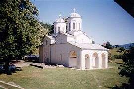
Image gallery
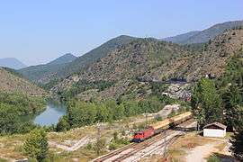 Belgrade–Bar railway in Priboj
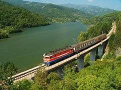 Belgrade–Bar railway train passing through Priboj
 Train station Priboj
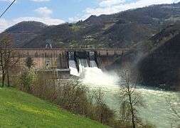 Potpeć HPP
Notable people
- Ana Bekuta, folk singer
- Marko Gudurić, basketball player, EuroBasket silver medalist
- Ahmet Delić, footballer
- Aleksandar Prijović, footballer
- Alem Toskić, handball player, European Championship silver medalist
- Amela Terzić, middle-distance runner, Universiade and European U23 champion
- Mirsad Terzić, Bosnian handball player
- Željka Nikolić, handball player
- Mustafa Hasanagić, retired footballer
- Slavenko Kuzeljević, football manager and former player
- Zlatan Alomerović, footballer
See also
References
- ↑ "Municipalities of Serbia, 2006". Statistical Office of Serbia. Retrieved 2010-11-28.
- ↑ "2011 Census of Population, Households and Dwellings in the Republic of Serbia: Comparative Overview of the Number of Population in 1948, 1953, 1961, 1971, 1981, 1991, 2002 and 2011, Data by settlements" (PDF). Statistical Office of Republic Of Serbia, Belgrade. 2014. ISBN 978-86-6161-109-4. Retrieved 2014-06-27.
- ↑ "Climate: Priboj, Serbia". Climate-Data.org. Retrieved 14 February 2018.
- ↑ Историја Прибоја [History of Priboj] (in Serbian). Priboj: Municipality of Priboj. Retrieved 2013-01-22.
Pod Tursku upravu Priboj dolazi između 1459. i 1463. godine, kada se prvi put u turskim izvorima i pominje.
- ↑ "2011 Census of Population, Households and Dwellings in the Republic of Serbia" (PDF). stat.gov.rs. Statistical Office of the Republic of Serbia. Retrieved 11 January 2017.
- ↑ "ОПШТИНЕ И РЕГИОНИ У РЕПУБЛИЦИ СРБИЈИ, 2017" (PDF). stat.gov.rs (in Serbian). Statistical Office of the Republic of Serbia. Retrieved 20 February 2018.
External links
| Wikimedia Commons has media related to Priboj. |
- Priboj.rs
- Tourist organization of Priboj - Turisticka organizacija Priboja
- Priboj 033 web portal about Priboj town


