Kraljevo
| Kraljevo Град Краљево | ||
|---|---|---|
| City | ||
| City of Kraljevo | ||
.jpg) 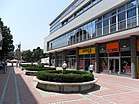 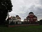 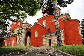 From top: City center square, St. Sava Church, Žiča Monastery, City center promenade | ||
| ||
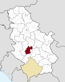 Location of the city of Kraljevo within Serbia | ||
| Coordinates: 43°43′25″N 20°41′15″E / 43.72361°N 20.68750°ECoordinates: 43°43′25″N 20°41′15″E / 43.72361°N 20.68750°E | ||
| Country |
| |
| Region | Šumadija and Western Serbia | |
| District | Raška | |
| Settlements | 92 | |
| Government | ||
| • Mayor | Predrag Terzic[1] (SNS) | |
| Area[2] | ||
| Area rank | 2nd in Serbia | |
| • Urban | 24.43 km2 (9.43 sq mi) | |
| • Administrative | 1,529.55 km2 (590.56 sq mi) | |
| Elevation | 192 m (630 ft) | |
| Population (2011 census)[3] | ||
| • Rank | 8th in Serbia | |
| • Urban | 68,749 | |
| • Urban density | 2,800/km2 (7,300/sq mi) | |
| • Administrative | 125,488 | |
| • Administrative density | 82/km2 (210/sq mi) | |
| Time zone | UTC+1 (CET) | |
| • Summer (DST) | UTC+2 (CEST) | |
| Postal code | 36000 | |
| Area code | +381(0)36 | |
| ISO 3166 code | SRB | |
| Car plates | KV | |
| Website |
www | |
Kraljevo (Serbian Cyrillic: Краљево; [krǎːʎɛʋɔ] (![]()
City is dominantly inhabited in the north part of the administrative area /Valley of West Morava, Sumadia/, while the part that belongs to the Ibar gorge /south part of area/ is sparsely populated due to less favorable terrain configuration.
In 2011 the city urban area has a population of 68,749 inhabitants, while the city administrative area has 125,488 inhabitants. With an area of 1530 km², it is the largest municipality (after Belgrade) in Serbia by area.
Name
Formerly known as Rudo Polje (Рудо Поље), Karanovac (Карановац) and Rankovićevo (Ранковићево), Kraljevo received its present name, meaning "the King's Town", from King Milan I of Serbia in honor of his own coronation and six Serbian kings that had been crowned in that area. The modern coat of arms of the city features seven crowns symbolizing the seven kings.
History and sights
The "lower" Ibar region is thought to be the first area where Serbs began to develop cultural, political and economic life. The Serbian state of Raška was formed in the 11th century, centered around the old city of Ras in the area of today's Novi Pazar. There are numerous monasteries in the Kraljevo area, Studenica (1188), Gradac and Stara Pavlica. There is also a medieval fortress known as Maglič. Monastery of Žiča (1219) was the original seat of Serbian Archbishop was used for the crowning of Serbian kings.
The village of Rudo Polje, from which Kraljevo arose, was settled during the 14th century. This area was occupied by the Turks between 1458 and 1459.
During the Turkish rule Rudo Polje became known as Karanovac. Karanovac became an important settlement during the war between Austria and Turkey in the period between 1718 and 1739. After 1718, a border between Austria and Turkey was established along right bank of river Morava, which led to Karanovac becoming a place of refuge for Turks who were fleeing from the Austrians.
During the first uprising of the Serbs in 1805, Karanovac was heavily damaged and most of the Turkish population left, leaving the Serbs to continue development of the city during the period following the uprising.
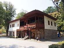
After the Second Serbian uprising, liberated Karanovac became the country capital in 1819 under the rule of Prince Miloš Obrenović. In that period the Orthodox Cathedral of the Holy Trinity was built; Gospodar Vasin konak, a mansion used by wealthy guests, as well as a number of significant public buildings. Kraljevo received the first urban plan, and became an important economic city.
In 1882 King Milan Obrenović, establishing the Kingdom of Serbia, in honor of his coronation, changed Karanovac name to Kraljevo, and gave the order for restoration of rather dilapidated monastery Žiča.
In 1919, Nikolaj Velimirović, was consecrated Bishop of Žiča and spent a brief period in the city. He returned again in 1935, and stayed until 1941. He rebuilt and enlarged the monastery.
During World War II Kraljevo was occupied by the German army. In 1941, local resistance fighters attacked a German garrison stationed near Kraljevo and killed 10 soldiers. In retaliation for the attack the Wehrmacht carried out the Kraljevo massacre, killing 2,000 residents of the city. A memorial complex constructed in the 1970s today commemorates the site of the massacre. In November 1944, heavy battles were fought in Kraljevo and its surrounding areas culminating in the city's liberation on 29 November 1944.
During the NATO bombing of Yugoslavia in 1999 the Lađevci Airport located near Kraljevo was bombed.
One prominent feature of the area is the Coronation church which belongs to the Žiča monastery. Seven Serbian kings are said to have been crowned (the seven crowns on the city coat of arms represent this assumption) in the church. The church is Byzantine in style, and has been partially restored, with only the main tower remaining from the original building dating to 1210, when it was founded by Saint Sava, the patron saint of Serbia.
The famous monastery of Studenica, 39 km (24 mi) south west of Kraljevo, stands high among the south-western mountains, overlooking the Studenica, a tributary of the Ibar. It consists of a group of old-fashioned timber and plaster buildings, a tall belfry, and a diminutive church of white marble, founded in 1190 by King Stefan Nemanja, who became a monk and was canonized as Saint Simeon. The carvings around the north, south and west doors have been partially defaced by the Turks. The inner walls are decorated with Byzantine frescoes, among which only a painting of the Last Supper, and the portraits of five saints remain from the original artwork. The dome and narthex are modern additions.
The silver shrine of Saint Simeon sits within the church, along with many gold and silver ornaments, church vessels and old manuscripts, and a set of vestments and a reliquary, believed by the monks to have been the property of Saint Sava who founded the first hospital in Studenica in the 13th century.
In various historical periods, Kraljevo was part of various administrative formats within Serbia, for example in the Kingdom of Serbs, Croats and Slovenes, as part of Northern Serbia, during the time of Kingdom of Yugoslavia as part of the Moravian Banovina, etc., and today it is officially part of Sumadija & Western Serbia Region
2010 earthquake
Kraljevo was shaken by a Mw 5.4 earthquake on 3 November 2010. Two people died and over 100 suffered light injuries. A number of buildings suffered damage, and several hundreds, chiefly older buildings, were rendered unusable.[4][5] There were several weaker aftershocks including a 4.3 Mw earthquake on November 4.[6][7]
Demographics
| Historical population | ||
|---|---|---|
| Year | Pop. | ±% p.a. |
| 1948 | 76,657 | — |
| 1953 | 82,454 | +1.47% |
| 1961 | 91,580 | +1.32% |
| 1971 | 106,153 | +1.49% |
| 1981 | 121,622 | +1.37% |
| 1991 | 125,772 | +0.34% |
| 2002 | 121,707 | −0.30% |
| 2011 | 125,488 | +0.34% |
| Source: [8] | ||
According to the 2011 census results, a total of 125,488 inhabitants live in the city administrative area of Kraljevo.
The city of Kraljevo has 41,358 households with 3,03 members on average, while the number of homes is 53,367.[9]
Religion structure in the city of Kraljevo is predominantly Serbian Orthodox (120,240), with minorities like Muslims (532), Atheists (487), Catholics (286), Protestants (82) and others.[10] Most of the population speaks Serbian language (122,007).[10]
The composition of population by sex and average age:[10]
- Male - 61,585 (41.02 years) and
- Female - 63,903 (43.45 years).
A total of 53,137 citizens (older than 15 years) have secondary education (49.78%), while the 15,281 citizens have higher education (14.31%). Of those with higher education, 9,326 (8.73%) have university education.[11]
Ethnic groups
Ethnic groups in the town of Kraljevo according to the 2011 census:[12]
| Ethnic group | Population 2011 |
|---|---|
| Serbs | 120,267 |
| Romani | 1,266 |
| Macedonians | 224 |
| Croats | 162 |
| Yugoslavs | 106 |
| Muslims | 44 |
| Russians | 40 |
| Bulgarians | 33 |
| Hungarians | 30 |
| Slovenes | 29 |
| Others | 3,287 |
| Total | 125,488 |
Settlements
At 1,530 square kilometres (591 sq mi) Kraljevo is the largest municipality of Serbia by area. Apart from the urban area, the city administrative area includes 92 settlements:
- Adrani
- Banjevac
- Bapsko Polje
- Bare
- Bogutovac
- Bojanići
- Borovo
- Bresnik
- Brezna
- Brezova
- Bukovica
- Bzovik
- Cerje
- Čibukovac
- Čukojevac
- Cvetke
- Đakovo
- Dedevci
- Dolac (Kraljevo)
- Dragosinjci
- Drakčići
- Dražiniće
- Drlupa
- Gledić
- Godačica
- Gokčanica
- Grdica
- Jarčujak
- Kamenica
- Kamenjani
- Konarevo
- Kovači
- Kovanluk
- Lađevci
- Lazac
- Leševo
- Lopatnica
- Lozno
- Maglič
- Mataruge
- Mataruška Banja
- Međurečje
- Meljanica
- Metikoš
- Milakovac
- Milavčići
- Miliće
- Miločaj
- Mlanča
- Mrsać
- Musina Reka
- Obrva
- Oplanići
- Orlja Glava
- Pečenog
- Pekčanica
- Petropolje
- Plana
- Polumir
- Popovići
- Predole
- Progorelica
- Ratina
- Ravanica
- Reka
- Ribnica
- Roćevići
- Rudnjak
- Rudno
- Samaila
- Savovo
- Sibnica
- Sirča
- Stanča
- Stubal
- Šumarice
- Tadenje
- Tavnik
- Tepeče
- Tolišnica
- Trgovište
- Ušće
- Vitanovac
- Vitkovac
- Vrba
- Vrdila
- Vrh
- Zaklopača
- Zakuta
- Zamčanje
- Zasad
- Žiča
Of those, Adrani, Centar, Čibukovac, Grdica, Higijenski Zavod, Jarčujak, Konarevo, Mataruge, Mataruška Banja, Metikoš, Ratina, Ribnica, Stara Čaršija, Vitanovac, Vrba, Zaklopača, Zelengora and Žiča lie within the proper city limits.
Economy
The following table gives a preview of total number of employed people per their core activity (as of 2016):[13]
| Activity | Total |
|---|---|
| Agriculture, forestry and fishing | 349 |
| Mining | 41 |
| Processing industry | 5,515 |
| Distribution of power, gas and water | 480 |
| Distribution of water and water waste management | 465 |
| Construction | 1,319 |
| Wholesale and retail, repair | 4,926 |
| Traffic, storage and communication | 2,185 |
| Hotels and restaurants | 1,186 |
| Media and telecommunications | 424 |
| Finance and insurance | 450 |
| Property stock and charter | 59 |
| Professional, scientific, innovative and technical activities | 931 |
| Administrative and other services | 580 |
| Administration and social assurance | 2,407 |
| Education | 2,039 |
| Healthcare and social work | 2,642 |
| Art, leisure and recreation | 380 |
| Other services | 642 |
| Total | 27,021 |
Tourism
Since 1990 an annual regatta called "Joyfull downhill" (Veseli spust) is held on the Ibar river. The course is 25 km (16 mi) long, starts at the Maglič fortress and ends in Kraljevo. It is held in the early July and in 2017 it was attended by over 300 boats and 5,000 people. Inaugural regatta in 1990 had 150 participants, but the number grew to 10,000 in 2004-06 and 20,000 in 2008.[14][15]
Sport
The most popular sports in Kraljevo are basketball, volleyball and football. The town is known as "Serbian Bologna" because it is home of KK Sloga and KK Mašinac both playing in Top Serbian basketball division - Naša Sinalko Liga. Kraljevo's volleyball team OK Ribnica recently became one of the best teams in Serbia. FK Sloga Kraljevo is the best Kraljevo football team.
Climate
| Climate data for Kraljevo (1981–2010, extremes 1961–2010) | |||||||||||||
|---|---|---|---|---|---|---|---|---|---|---|---|---|---|
| Month | Jan | Feb | Mar | Apr | May | Jun | Jul | Aug | Sep | Oct | Nov | Dec | Year |
| Record high °C (°F) | 20.0 (68) |
23.4 (74.1) |
30.3 (86.5) |
32.1 (89.8) |
34.6 (94.3) |
39.2 (102.6) |
43.6 (110.5) |
41.0 (105.8) |
37.3 (99.1) |
32.8 (91) |
28.6 (83.5) |
22.0 (71.6) |
43.6 (110.5) |
| Average high °C (°F) | 4.4 (39.9) |
7.2 (45) |
12.4 (54.3) |
17.9 (64.2) |
22.9 (73.2) |
25.9 (78.6) |
28.4 (83.1) |
28.6 (83.5) |
23.7 (74.7) |
18.1 (64.6) |
10.9 (51.6) |
5.4 (41.7) |
17.2 (63) |
| Daily mean °C (°F) | 0.3 (32.5) |
2.3 (36.1) |
6.8 (44.2) |
11.8 (53.2) |
16.7 (62.1) |
19.8 (67.6) |
21.8 (71.2) |
21.5 (70.7) |
16.8 (62.2) |
11.8 (53.2) |
6.0 (42.8) |
1.6 (34.9) |
11.5 (52.7) |
| Average low °C (°F) | −3.2 (26.2) |
−2.0 (28.4) |
1.7 (35.1) |
5.9 (42.6) |
10.5 (50.9) |
13.7 (56.7) |
15.1 (59.2) |
15.0 (59) |
11.1 (52) |
6.8 (44.2) |
2.0 (35.6) |
−1.7 (28.9) |
6.2 (43.2) |
| Record low °C (°F) | −24.0 (−11.2) |
−23.6 (−10.5) |
−14.4 (6.1) |
−6.3 (20.7) |
−1.6 (29.1) |
2.9 (37.2) |
7.0 (44.6) |
3.1 (37.6) |
−1.8 (28.8) |
−5.6 (21.9) |
−17.4 (0.7) |
−19.2 (−2.6) |
−24.0 (−11.2) |
| Average precipitation mm (inches) | 45.1 (1.776) |
45.4 (1.787) |
52.9 (2.083) |
62.6 (2.465) |
71.2 (2.803) |
92.2 (3.63) |
76.8 (3.024) |
64.9 (2.555) |
59.1 (2.327) |
57.3 (2.256) |
56.6 (2.228) |
56.1 (2.209) |
740.3 (29.146) |
| Average precipitation days (≥ 0.1 mm) | 13 | 13 | 13 | 13 | 14 | 13 | 10 | 9 | 10 | 10 | 11 | 14 | 143 |
| Average snowy days | 9 | 9 | 6 | 1 | 0 | 0 | 0 | 0 | 0 | 0 | 4 | 8 | 37 |
| Average relative humidity (%) | 81 | 75 | 69 | 66 | 69 | 70 | 68 | 68 | 74 | 77 | 79 | 83 | 73 |
| Mean monthly sunshine hours | 57.6 | 86.6 | 133.3 | 160.3 | 214.3 | 225.8 | 267.1 | 257.5 | 181.3 | 137.3 | 76.8 | 44.8 | 1,841.8 |
| Source: Republic Hydrometeorological Service of Serbia[16] | |||||||||||||
Famous residents
NBA player Vlade Divac started his career in Kraljevo, while playing for "Sloga" basketball club (his wife is from Kraljevo). He now donates to the club. Another NBA player, Nenad Krstić was born in Kraljevo, and played for "Mašinac" basketball club from Kraljevo. Kraljevo is the birthplace of international footballer Aleksandar Luković.
International relations
Twin towns — Sister cities
Kraljevo is twinned with:
Gallery
 Archive in Kraljevo
 Ibar River, Kraljevo
 Park, Kraljevo
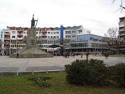 City center square
 Church of Saint Sava, Kraljevo
 Inside the Cathedral of Saint Sava, Kraljevo
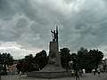 Monument to the Serbian Soldier, Kraljevo
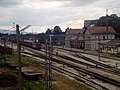 Kraljevo Train Station
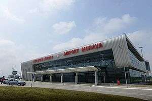 Morava Airport
See also
References
- ↑ "Novi gradonačelnik Kraljeva Tomislav Ilić iz Nove Srbije". Blic (in Serbian). 20 June 2014. Retrieved 12 April 2015.
- ↑ "Municipalities of Serbia, 2006". Statistical Office of Serbia. Retrieved 2010-11-28.
- ↑ "2011 Census of Population, Households and Dwellings in the Republic of Serbia: Comparative Overview of the Number of Population in 1948, 1953, 1961, 1971, 1981, 1991, 2002 and 2011, Data by settlements" (PDF). Statistical Office of Republic Of Serbia, Belgrade. 2014. ISBN 978-86-6161-109-4. Retrieved 2014-06-27.
- ↑ "OCP Error page". www.danas.rs.
- ↑ "2 killed in earthquake in central Serbia".
- ↑ Serbia, RTS, Radio televizija Srbije, Radio Television of. "Dan posle zemljotresa".
- ↑ "Magnitude 4.3 - SERBIA".
- ↑ "2011 Census of Population, Households and Dwellings in the Republic of Serbia" (PDF). stat.gov.rs. Statistical Office of the Republic of Serbia. Archived from the original (PDF) on 14 July 2014. Retrieved 11 January 2017.
- ↑ "Number and the floor space of housing units" (PDF). stat.gov.rs (in Serbian). Statistical Office of the Republic of Serbia. Retrieved 21 March 2018.
- 1 2 3 "Religion, Mother tongue, and Ethnicity" (PDF). stat.gov.rs (in Serbian). Statistical Office of the Republic of Serbia. Retrieved 21 March 2018.
- ↑ "Educational attainment, literacy and computer literacy" (PDF). stat.gov.rs (in Serbian). Statistical Office of the Republic of Serbia. Retrieved 21 March 2018.
- ↑ "Попис становништва, домаћинстава и станова 2011. у Републици Србији" (PDF). stat.gov.rs. Republički zavod za statistiku. Archived from the original (PDF) on 11 August 2014. Retrieved 15 December 2016.
- ↑ "ОПШТИНЕ И РЕГИОНИ У РЕПУБЛИЦИ СРБИЈИ, 2017" (PDF). stat.gov.rs (in Serbian). Statistical Office of the Republic of Serbia. Retrieved 20 February 2018.
- ↑ M.Dugalić (3 July 2017), "Veseli spust uz povoljan vetar", Politika (in Serbian), p. 05
- ↑ "Veseli spust niz Ibar" (in Serbian). Radio Television Serbia. 4 July 2015.
- ↑ "Monthly and annual means, maximum and minimum values of meteorological elements for the period 1981–2010" (in Serbian). Republic Hydrometeorological Service of Serbia. Retrieved March 13, 2018.
- ↑ "Zielona Góra Miasta partnerskie". Urząd Miasta Zielona Góra. Retrieved 2013-06-24.
External links
| Wikimedia Commons has media related to Kraljevo. |

- City of Kraljevo official website
- kraljevopress
- Kraljevo oglasi - Local community ads


| Villages |
|  |
|---|---|---|
| Landmarks | ||
| Notable people | ||
| Authority control |
|---|