Palilula, Niš
| Palilula Палилула | ||
|---|---|---|
| City municipality | ||
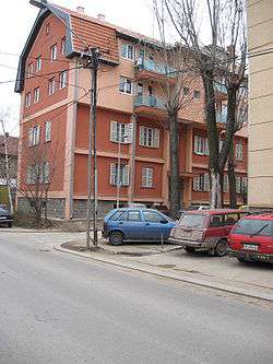 Old workers colony | ||
| ||
| Country |
| |
| Region | Southern and Eastern Serbia | |
| District | Nišava | |
| City | Niš | |
| Founded | 6 June 2002 | |
| Government | ||
| • Mayor | Boban Džunić (SNS) | |
| Area | ||
| • Municipality | 116.64 km2 (45.03 sq mi) | |
| Population (2011 census)[1] | ||
| • Urban | 52,693 | |
| • Municipality | 71,707 | |
| Time zone | UTC+1 (CET) | |
| • Summer (DST) | UTC+2 (CEST) | |
| Postal code | 18000 | |
| Area code | +381(0)18 | |
| Car plates | NI | |
| Website |
palilula | |
.png)
Palilula (Serbian: Палилула; pronounced [pǎlilula]) is one of five city municipalities which constitute the city of Niš. It has a population of 71,707 inhabitants. It was formed on 6 June 2002.
Geography
The municipality borders Crveni Krst and Medijana municipalities in the north, Niška Banja municipality in the east, Gadžin Han and Doljevac municipalities in the south, and Merošina municipality in the south-west.
Neighborhoods
Neighborhoods of Palilula include:
- Palilula
- Staro Groblje
- Crni put
- Bubanj
- Ledena Stena
- Delijski Vis
- Apelovac
- Kovanluk
- Tutunović Podrum
- Kalac Brdo
- Suvi Do
See also
References
- ↑ "2011 Census of Population, Households and Dwellings in the Republic of Serbia: Comparative Overview of the Number of Population in 1948, 1953, 1961, 1971, 1981, 1991, 2002 and 2011, Data by settlements" (PDF). Statistical Office of Republic Of Serbia, Belgrade. 2014. ISBN 978-86-6161-109-4. Retrieved 2014-06-27.
External links
| Wikimedia Commons has media related to Palilula (Niš). |

Coordinates: 43°18′32″N 21°51′54″E / 43.30889°N 21.86500°E
This article is issued from
Wikipedia.
The text is licensed under Creative Commons - Attribution - Sharealike.
Additional terms may apply for the media files.