Pećinci
| Pećinci Пећинци | ||
|---|---|---|
| Town and municipality | ||
 | ||
| ||
 Location of the municipality of Pećinci within Serbia | ||
| Coordinates: 44°54′N 19°58′E / 44.900°N 19.967°ECoordinates: 44°54′N 19°58′E / 44.900°N 19.967°E | ||
| Country |
| |
| Province | Vojvodina | |
| District | Srem | |
| Settlements | 15 | |
| Government | ||
| • Mayor | Sava Čojčić | |
| Area[1] | ||
| • Town | 19.27 km2 (7.44 sq mi) | |
| • Municipality | 488.72 km2 (188.70 sq mi) | |
| Elevation | 83 m (272 ft) | |
| Population (2011 census)[2] | ||
| • Town | 2,571 | |
| • Town density | 130/km2 (350/sq mi) | |
| • Municipality | 19,675 | |
| • Municipality density | 40/km2 (100/sq mi) | |
| Time zone | UTC+1 (CET) | |
| • Summer (DST) | UTC+2 (CEST) | |
| Postal code | 22410 | |
| Area code | +381(0)22 | |
| Car plates | RU | |
| Website |
www | |


Pećinci (Serbian Cyrillic: Пећинци, pronounced [pětɕiːntsi]) is a town and municipality located in the Srem District of the autonomous province of Vojvodina, Serbia. The village has a population of 2,571 (2011), while Pećinci municipality has 19,675 inhabitants.
Name
In Serbian, the village is known as Pećinci (Пећинци), in Croatian as Pećinci, in Hungarian as Pecsince, in German as Petschinzi, in Slovak as Pečinci, and in Rusyn as Печинци. Its name derived from the Serbian word "peć/пећ" ("furnace" in English), or "petlja/петља" ("loop" or "noose" in English).
History
The village was first time recorded by the sources in 1416. After that time, there were no other records about this settlement until 1702. The village was under Ottoman administration until the Treaty of Passarowitz (1718), when it passed to Habsburg Monarchy. During Habsburg administration, it was part of the Habsburg Military Frontier. From 1848 to 1849, the village was part of Serbian Vojvodina, but was again included into Military Frontier in 1849. After abolishment of the frontier (in 1882), it was included into Syrmia County of Croatia-Slavonia, which was an autonomous kingdom within the Kingdom of Hungary and Austria-Hungary. According to 1910 census, the village had Serb ethnic majority.
In 1918, the village first became part of the State of Slovenes, Croats and Serbs, then part of the Kingdom of Serbia, and finally part of the newly formed Kingdom of Serbs, Croats and Slovenes (later renamed to Yugoslavia). From 1918 to 1922, village was part of the Syrmia County, from 1922 to 1929 part of the Syrmia oblast, and from 1929 to 1941 part of the Danube Banovina. From 1941 to 1944, the village was occupied by the Axis Powers and was attached to Pavelić's Independent State of Croatia. Territory of present-day Pećinci municipality was an important center of partisan resistance movement and a partisan liberated territory was formed in this area during the war.
After the war, the village became part of Vojvodina, an autonomous province of the Socialist Republic of Serbia and Socialist Federative Republic of Yugoslavia. Until 1960, villages of present-day Pećinci municipality were part of the municipalities of Ruma, Stara Pazova and Zemun (village of Pećinci itself was part of Zemun municipality). A separate municipality of Pećinci was formed in 1960 and village of Pećinci was chosen for municipal center because of its favorable traffic position.
Inhabited places
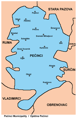
Aside from the village of Pećinci, municipality includes the following villages:
Demographics
| Historical population | ||
|---|---|---|
| Year | Pop. | ±% p.a. |
| 1948 | 18,800 | — |
| 1953 | 18,567 | −0.25% |
| 1961 | 19,289 | +0.48% |
| 1971 | 18,490 | −0.42% |
| 1981 | 19,284 | +0.42% |
| 1991 | 20,077 | +0.40% |
| 2002 | 21,560 | +0.65% |
| 2011 | 19,720 | −0.99% |
| Source: [3] | ||
According to the 2011 census results, the municipality of Šid has 19,720 inhabitants.
Ethnic groups
All settlements in the municipality have an ethnic Serb majority. The ethnic composition of the municipality:[4]
| Ethnic group | Population |
|---|---|
| Serbs | 17,965 |
| Romani | 1,008 |
| Slovaks | 79 |
| Croats | 42 |
| Macedonians | 33 |
| Montenegrins | 22 |
| Yugoslavs | 22 |
| Hungarians | 21 |
| Muslims | 11 |
| Russians | 11 |
| Bosniaks | 11 |
| Others | 495 |
| Total | 19,720 |
Economy
The following table gives a preview of total number of employed people per their core activity (as of 2016):[5]
| Activity | Total |
|---|---|
| Agriculture, forestry and fishing | 206 |
| Mining | 5 |
| Processing industry | 2,076 |
| Distribution of power, gas and water | 11 |
| Distribution of water and water waste management | 46 |
| Construction | 87 |
| Wholesale and retail, repair | 1,827 |
| Traffic, storage and communication | 359 |
| Hotels and restaurants | 106 |
| Media and telecommunications | 99 |
| Finance and insurance | 10 |
| Property stock and charter | 3 |
| Professional, scientific, innovative and technical activities | 93 |
| Administrative and other services | 33 |
| Administration and social assurance | 162 |
| Education | 279 |
| Healthcare and social work | 215 |
| Art, leisure and recreation | 56 |
| Other services | 37 |
| Total | 5,711 |
See also
References
- ↑ "Municipalities of Serbia, 2006". Statistical Office of Serbia. Retrieved 2010-11-28.
- ↑ "2011 Census of Population, Households and Dwellings in the Republic of Serbia: Comparative Overview of the Number of Population in 1948, 1953, 1961, 1971, 1981, 1991, 2002 and 2011, Data by settlements" (PDF). Statistical Office of Republic Of Serbia, Belgrade. 2014. ISBN 978-86-6161-109-4. Retrieved 2014-06-27.
- ↑ "2011 Census of Population, Households and Dwellings in the Republic of Serbia" (PDF). stat.gov.rs. Statistical Office of the Republic of Serbia. Retrieved 19 August 2017.
- ↑ "ETHNICITY Data by municipalities and cities" (PDF). stat.gov.rs. Statistical Office of the Republic of Serbia. Retrieved 22 February 2018.
- ↑ "ОПШТИНЕ И РЕГИОНИ У РЕПУБЛИЦИ СРБИЈИ, 2017" (PDF). stat.gov.rs (in Serbian). Statistical Office of the Republic of Serbia. Retrieved 22 February 2018.
External links
| Wikimedia Commons has media related to Pećinci. |


