Peć
| Peć Пећ/Peć (Serbian) Peja or Pejë (Albanian) | |
|---|---|
| City and municipality | |
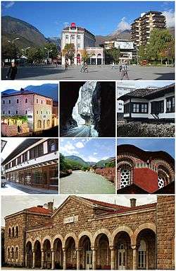 From top (left to right): Peć city center, Zenel Beg Tower (Kulla), Rugova Canyon, Ethnological Museum, Old Bazaar, Bistrica River, Patriarchal Monastery of Peć and the train station of Peć. | |
 Location of the city of Peć within Kosovo | |
| Coordinates: 42°39′N 20°18′E / 42.650°N 20.300°ECoordinates: 42°39′N 20°18′E / 42.650°N 20.300°E | |
| Country | Kosovo[a] |
| District | District of Peć |
| Government | |
| • Mayor | Gazmend Muhaxheri |
| Area | |
| • Urban | 21 km2 (8 sq mi) |
| • Municipal | 603 km2 (233 sq mi) |
| Elevation | 550 m (1,800 ft) |
| Population (2016) | |
| • Urban | 48,962 |
| • Urban density | 2,300/km2 (6,000/sq mi) |
| • Municipal | 97,890 |
| • Municipal density | 160/km2 (420/sq mi) |
| As of 2009[1] | |
| Time zone | UTC+1 (CET) |
| • Summer (DST) | UTC+2 (CEST) |
| ZIP code | 30000 |
| Area code(s) | +383 39 |
| Vehicle registration | 03 |
| Website |
kk |
Peć (Serbian Cyrillic: Пећ) or Peja (Albanian: Pejë), is a city and municipality located in the Peć District of Kosovo[lower-alpha 1]. According to the 2011 census, the city of Peć has 48,962 inhabitants, while the municipality has 97,890 inhabitants. The municipality covers an area of 602 km2 (232 sq mi), including the city of Peć and 95 villages; it is divided into 28 territorial communities.
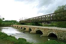
Geographically, it is located in an important location on the Peć Bistrica, a tributary of the White Drin to the east of the Prokletije Mountains. The Rugova Canyon is one of Europe's longest and deepest canyons and is about three kilometres from the city of Peć. The city is located some 250 kilometres (155 miles) north of Tirana, Albania, 150 kilometres (93 miles) north-west of Skopje, Republic of Macedonia, 85 kilometres (52 miles) west of Pristina, Kosovo and some 280 kilometres (173 miles) east of Podgorica, Montenegro.
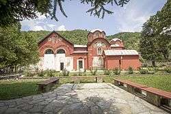
In medieval times the city was the seat of the Serbian Orthodox Church in 1346. Later in 1899, the Albanian political organization, League of Peja, was established in the city. The patriarchal monastery of Peć is a UNESCO World Heritage Site as part of the Medieval Monuments in Kosovo.
Name
In Serbian, peć means "furnace" or "cave", and its name is probably connected with nearby caves in the Rugova Canyon which served as hermit cells for Serbian Orthodox monks.[2] In medieval Ragusan documents, the Serbian name of the city (Peć, lit. "furnace") is sometimes translated as Forno, meaning "furnace" in Italian. During Ottoman rule, it was known as Ottoman Turkish İpek (ايپك). The Albanian name's definite form is Peja and the indefinite Pejë. Other names of the city include Latin Pescium and Greek Episkion (Επισκιον).
History
Ancient and medieval history
The city is located in a strategic position on the Pećka Bistrica, a tributary of the White Drin to the east of the Prokletije. The medieval city was possibly built on the ruins of Siparant(um), a Roman municipium (town or city).[3] The area has the most unearthed stelae in all of Kosovo.[3]
Slavs (Sclaveni and Antes) settled the Balkans, heavily depopulated by "barbarians", in the 6th century. The Byzantine Empire and the First Bulgarian Empire fought for control of the area until it finally fell under full Serbian control. Between 1180 and 1190, Serbian Grand Prince Stefan Nemanja liberated Peć with its surrounding župa (district) of Hvosno from the Byzantine Empire, thus establishing Serbian rule over the city of Peć for next 300 years.[4] In 1220, Serbian King Stefan Nemanjić donated Peć and several surrounding villages to his newly founded monastery of Žiča.[5] As Žiča was the seat of a Serbian archbishop, Peć came under direct rule of Serbian archbishops and later patriarchs who built their residences and numerous churches in the city starting with the church of Holy Apostles built by archbishop Saint Arsenije I Sremac. After the Žiča monastery was burned by the Cumans (between 1276 and 1292) the seat of Serbian archbishop was transferred to a more secure location - Patriarchal Monastery of Peć where it remained until the abolition of the Serbian Patriarchate of Peć in 1766.
The city became a major religious center of medieval Serbia under the Serbian Emperor Stefan Dušan, who made it the seat of the Serbian Orthodox Church in 1346. It retained this status until 1766, when the Serbian Patriarchate of Peć was abolished. Today, Peć holds the memory of old Serbian Patriarchate. The city and its surrounding area are still revered by adherents of Serbian Orthodoxy; the city is the site of the Patriarchal Monastery of Peć, which is an easy walk from the city center and consists of four fresco-decorated churches, a library, and a treasury. The 14th century Visoki Dečani monastery, a UNESCO World Heritage Site, lies about 19 km (12 mi) south, in nearby Deçan.
Ottoman era
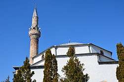
Peja came under Ottoman rule after its capture in 1455.[6] In Turkish, the town was known as İpek. The town became the center of the Sanjak of İpek (or Dukagjin), governed by Mahmut Pasha Dukagjini as its first sanjakbey (lord).[7] The Sanjak of Dukagjin had four kazas: Peć, Gjakova, Gusinje and Berane.[8] The city was settled by a large number of Turks, many of whose descendants still live in the area, and took on a distinctly oriental character with narrow streets and Ottoman-style houses. It also gained an Islamic character with the construction of a number of mosques, many of which still remain. One of these is the centrally located Bajrakli Mosque built in the 15th century.
The Albanian nationalist organization League of Peja established in 1899 was based in the city. The organization, led by Haxhi Zeka, adopted the character of the earlier League of Prizren to defend the rights of Ottoman Albanians and seek autonomous status within the empire. After an armed conflict with Ottoman forces in 1900 the organization ended its operations.[9]
Contemporary period
Ottoman rule came to an end in the First Balkan War of 1912–13, when Montenegro took control of the city on 28 October 1912. On 8 January 1916, during World War I, Austria-Hungary took the city. Peć was taken by Serbian forces on 17 October 1918. After World War I, the city became part of Yugoslavia (at first officially called the Kingdom of Serbs, Croats and Slovenes). Between 1931 and 1941 the city was part of Zeta Banovina. During World War II Peć was occupied by the Italian puppet state of Albania. After the war, Peć again became part of Yugoslavia as part of the Autonomous Region of Kosovo and Metohija (1945–1963), an autonomous unit within the Socialist Republic of Serbia.
Relations between Serbs and Albanians, who were the majority population, were often tense during the 20th century. They came to a head in the Kosovo War of 1999, during which the city suffered heavy damage and mass killings.[10] More than 80 percent of the total 5280 houses in the city were heavily damaged (1590) or destroyed (2774).[11] It suffered further damage in violent inter-ethnic unrest in 2004.
Geography
Location
The city in Western Kosovo near the Rugova Canyon or Gorge. Rugova is a mountainous region entered through the North-West part of the city of Peć. It is the third region of Prokletije. In 2013 it became a National Park of the Republic of Kosovo. Rugova is known for its natural beauty and access to the mountains.
Administration
The municipality covers an area of 602 km2 (232 sq mi), including the city of Peć and 95 villages; it is divided into 28 territorial communities.[1] As of 2011, the whole municipality has a population of approximately 95,723,[1] of which ca. 60,000 live in the city of Peć.[12] There are two Tourist Information offices supported by the municipality, in the city, one in the center opposite the Hotel Dukagjini and one at the entrance to the Rugova Canyon.
Climate
| Climate data for Peć (1961–1990) | |||||||||||||
|---|---|---|---|---|---|---|---|---|---|---|---|---|---|
| Month | Jan | Feb | Mar | Apr | May | Jun | Jul | Aug | Sep | Oct | Nov | Dec | Year |
| Record high °C (°F) | 15.4 (59.7) |
22.6 (72.7) |
25.0 (77) |
28.0 (82.4) |
31.5 (88.7) |
35.8 (96.4) |
38.2 (100.8) |
35.9 (96.6) |
34.1 (93.4) |
28.3 (82.9) |
22.9 (73.2) |
18.9 (66) |
38.2 (100.8) |
| Average high °C (°F) | 2.8 (37) |
6.0 (42.8) |
10.9 (51.6) |
16.1 (61) |
20.9 (69.6) |
24.1 (75.4) |
26.5 (79.7) |
26.4 (79.5) |
22.7 (72.9) |
16.9 (62.4) |
10.1 (50.2) |
4.5 (40.1) |
15.7 (60.3) |
| Daily mean °C (°F) | −0.5 (31.1) |
2.1 (35.8) |
6.4 (43.5) |
11.2 (52.2) |
15.9 (60.6) |
19.0 (66.2) |
21.1 (70) |
20.8 (69.4) |
17.2 (63) |
11.8 (53.2) |
5.9 (42.6) |
1.2 (34.2) |
11.1 (52) |
| Average low °C (°F) | −3.6 (25.5) |
−1.5 (29.3) |
2.0 (35.6) |
6.1 (43) |
10.3 (50.5) |
13.3 (55.9) |
15.0 (59) |
14.8 (58.6) |
11.5 (52.7) |
6.8 (44.2) |
2.3 (36.1) |
−1.8 (28.8) |
6.3 (43.3) |
| Record low °C (°F) | −24.8 (−12.6) |
−19.3 (−2.7) |
−13.6 (7.5) |
−3.8 (25.2) |
0.6 (33.1) |
3.5 (38.3) |
6.7 (44.1) |
5.2 (41.4) |
−1.2 (29.8) |
−4.8 (23.4) |
−15.3 (4.5) |
−15.2 (4.6) |
−24.8 (−12.6) |
| Average precipitation mm (inches) | 85.9 (3.382) |
71.5 (2.815) |
65.2 (2.567) |
67.2 (2.646) |
68.2 (2.685) |
53.0 (2.087) |
54.7 (2.154) |
48.0 (1.89) |
52.1 (2.051) |
75.3 (2.965) |
118.2 (4.654) |
91.4 (3.598) |
850.7 (33.492) |
| Average precipitation days (≥ 0.1 mm) | 12.0 | 12.3 | 11.3 | 11.5 | 13.0 | 13.2 | 9.9 | 8.7 | 8.1 | 9.5 | 12.3 | 13.3 | 135.1 |
| Average snowy days | 8.1 | 6.0 | 3.7 | 0.6 | 0.0 | 0.0 | 0.0 | 0.0 | 0.0 | 0.1 | 2.0 | 6.5 | 27.0 |
| Average relative humidity (%) | 81 | 75 | 68 | 63 | 64 | 64 | 60 | 60 | 67 | 73 | 81 | 83 | 70 |
| Mean monthly sunshine hours | 69.5 | 93.3 | 143.0 | 172.0 | 207.8 | 257.7 | 274.3 | 264.9 | 206.3 | 152.6 | 86.8 | 55.3 | 1,983.5 |
| Source: Republic Hydrometeorological Service of Serbia[13] | |||||||||||||
Demographics
| Historical population | ||
|---|---|---|
| Year | Pop. | ±% p.a. |
| 1948 | 47,009 | — |
| 1953 | 53,548 | +2.64% |
| 1961 | 66,656 | +2.77% |
| 1971 | 90,124 | +3.06% |
| 1981 | 111,071 | +2.11% |
| 1991 | 127,796 | +1.41% |
| 2011 | 96,450 | −1.40% |
| 2016 est. | 97,890 | +0.30% |
| Source: Division of Kosovo | ||
According to the last official census done in 2011, the city of Peć has 96,450 inhabitants.
According to the 1981 census, the city urban area had a population of 54,497 inhabitants; according to the 1991 census it had grown to 68,163.[12] According to the 2011 census, around 49,000 people live in the city of Peć.[12]
Ethnic groups
The vast majority of the inhabitants are Kosovo Albanians. Most Kosovo Serbs live in the village enclaves of Goraždevac, Belo Polje and Ljevoša. There is also a large Bosniak community in the city of Peć and in Vitomirica, while significant Roma, Ashkali and Egyptian communities reside in urban and rural areas.[1]
The ethnic composition of the city municipal area:
| Year/Population | Albanians | % | Serbs | % | Montenegrins | % | Roma (Ashkali, Egyptians) | % | Bosniaks | % | Others | % | Total |
|---|---|---|---|---|---|---|---|---|---|---|---|---|---|
| 1961 Census | 41,532 | 62.35 | 8,852 | 13.28 | 12,701 | 19.05 | 728 | 1.09 | 1,397 | 2.1 | 66,656 | ||
| 1971 Census | 63,193 | 70.12 | 9,298 | 10.31 | 11,306 | 12.54 | 433 | 0.48 | 5,203 | 5.77 | 90,124 | ||
| 1981 Census | 79,965 | 71.99 | 7,995 | 7.2 | 9,796 | 8.82 | 3,844 | 3.46 | 8,739 | 7.86 | 111,071 | ||
| 1991 Census | 96,441 | 75.5 | 7,815 | 6.11 | 6,960 | 5.44 | 4,442 | 3.5 | 9,875 | 7.72 | 127,796 | ||
| January 1999 | ~104,600 | ~92 | n/a | n/a | n/a | n/a | ~3,500–4,000 | ~3.3 | n/a | n/a | ~4,000–4,200 | ~3.6 | ~113,000 |
| 2011 census | 87,975 | 91.2 | 332 | 0.4 | 3,836 | 3.9 | 3,786 | 3.9 | 521 | 0.5 | 96,450 | ||
| Source: Yugoslav Population Censuses for data through 1991, OSCE estimates for data from 1999, and 2011 census from Kosovo Republic.[1][14] | |||||||||||||
Education
Education in Peć is a system with no tuition or fees, mandatory for all children between the ages of 6-18. It consists of a nine-year basic comprehensive school (starting at age six and ending at the age of fifteen) secondary general and professional education commonly known as high school and higher education at Haxhi Zeka University of Peja. It also includes non-mandatory daycare programs for babies and toddlers and a one-year "preschool". The school year runs from early September to late June of the following year. Winter break runs from late December to early January, dividing the school year into two semesters. Peć is the only city in Kosovo that offers high school education in arts and there is also a school for the visually impaired.
Economy
Tourism
Peć is rapidly developing a significant tourist infrastructure. You can find information and maps for the "Trail of Cultural Monuments" at the Tourist Information Office as well as maps and attractions in the Rugova Gorge/Canyon and surrounding mountains. Skiing is available at the Ski Center in Bogë nearby. One of the most exciting new attractions is the Peak of the Balkans trail. The trail wanders through 3 countries with spectacular mountain views and can be well-supported by local guides and tour companies. Pećka Banja is a township located in the municipality of Istok, Kosovo. To many people it is known with the name Ilixhe. It is a touristic-health center with services in Istok and in the region, highly developed infrastructure and every service needed for healthy living.[15] The cite has seen a bloom of tourism with a new Zip Line, and two Via Ferrata, built between 2013 and 2016. In the city there are a number of tour operators that function, with Balkan Natural Adventure, being the main one with a full palette of services.
Culture
Architecture
%2C_Pej%C3%AB_4.jpg)
The architecture in Peć show different architectural styles, from the medieval Serbian, Ottoman, Yugoslav, and contemporary architecture. Because of this there are many churches, mosques, buildings which are attraction points in the city and were built by the aforementioned influences.
Notable architectural traits of Peć include:
- Patriarchal Monastery of Peć, 13th-century Serbian Orthodox monastery, the historical seat of the Serbian Orthodox Church. It is a World Heritage Site of Serbia, under the entry "Medieval Monuments in Kosovo". It is protected now by the Kosovo police which replaced the Kosovo Force.
- Bazaar of Peć, Ottoman-era market in the center of the city. It was destroyed during World War II and the Kosovo War. It has been fully rebuilt.
- Bajrakli Mosque, Ottoman-built mosque in the Bazaar of Peć. It was destroyed during World War II and then rebuilt.
- Peć Hamam, Ottoman-era bath
Events and festivals
Sport
Peć is one of the more successful cities in Kosovan sport. The city is home to the first Olympic Medal for Kosovo, won by Judoka Majlinda Kelmendi in Rio de Janeiro Games in 2016. Her team also has won numerous other medals including gold and bronze in the World and European championships. Main football team of the city is KF Besa, its basketball teams is KB Peja. KB Peja is the older and more established basketball team. Additionally the city is host to a handball team, KH BESA Famiglia, a volleyball team KV BESA, a judo team Ippon, an athletic team Besa as well as a women's basketball team KB Penza. Since June 2008 Peć has also a Taekwondo Team: Tae Kwon Do Club Peja (Klubi i Tae Kwon Do-së Peja).[16]
Paragliding
Peć has its aeroclub called "Aeroklub Peć", which was founded in 1948. Last years this club is part of competitions in several countries. In June 2013 it was the organizer of "second Paragliding event" which included paragliders from Kosovo and Albania[17] In 2014 it was the organizer of an international contest called "Peja open PARAGLIDING CUP 2014".[18]
International relations
Peć is twinned with Gjilan which is also in Kosovo; Horby in Sweden, Tobolsk in Russia and Nilüfer in Turkey.
Notable people
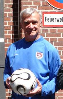
.JPG)
- Saint Sava, first Archbishop of the Serbian Orthodox Church and founder of the Monastery of Peć
- Arsenije Sremac, secound Archbishop of the Serbian Orthodox Church and first who resided in the Monastery of Peć
- Joanikije II, Serbian Patriarch
- Arsenije IV Jovanović Šakabenta, Serbian Patriarch
- David Albahari, Serbian author
- Mehmet Akif Ersoy, Turkish poet, who wrote the Turkish National Anthem
- Fatos Bećiraj, Albanian football player, who plays for the Montenegrin national football team
- Faruk Begolli, Albanian actor
- Qerim Begolli, signatory of the Albanian Declaration of Independence
- Vladimir Božović, Montenegrin football player
- Đorđe Božović, Serb paramilitary leader
- Agim Çavdarbasha, former Albanian sculptor
- Agim Çeku, military commander of the KLA during the 1999 Kosovo War, minister of Security Force of Kosovo
- Majlinda Kelmendi, Olympic, World and European judo champion
- Salih Gjuka, signatory of the Albanian Declaration of Independence
- Bedri bej Ipeku, Albanian politician
- Bogoljub Karić, Serbian politician and businessman
- Gezim Kasapolli, politician
- Rustemi Kreshnik, Albanian kickboxer
- Miodrag Krivokapić, Serbian actor
- Rahman Morina, Albanian politician
- Xhevdet Muriqi, former Albanian football player, part of the "Golden Generation" of KF Prishtina
- Fadil Muriqi, former Albanian football player, part of the "Golden Generation" of KF Prishtina
- Riza Sapunxhiu, Albanian politician
- Milutin Šoškić, former Serbian football player, Olympic champion
- Ranko Popović, former Serbian football player and a current coach
- Dejan Stojanović, Serbian-Montenegrin writer
- Pavle Strugar, retired Montenegrin general in the Yugoslav People's Army (JNA)
- Sislej Xhafa, Albanian artist
- Haxhi Zeka, Albanian national leader
- Zhuj Selmani, League of Prizren hero
See also
Notes
- ↑ Kosovo is the subject of a territorial dispute between the Republic of Kosovo and the Republic of Serbia. The Republic of Kosovo unilaterally declared independence on 17 February 2008, but Serbia continues to claim it as part of its own sovereign territory. The two governments began to normalise relations in 2013, as part of the Brussels Agreement. Kosovo has received formal recognition as an independent state from 113 out of 193 United Nations member states.
References
- 1 2 3 4 5 Archived June 6, 2011, at the Wayback Machine.
- ↑
- 1 2 Mirko Pak; Igor Vrišer (1980), Urban and industrial geography, Inštitut za geografija univerze Edvarda Kardelja v Ljubljani,
Prema tome, od gore spomenutih cinjenica mozemo pretpostaviti da je stara Pec bila municipij i da se u dardansko-rimsko doba nazivala Siparant, odnosno Slparantum.
- ↑ John V. A. Fine; John Van Antwerp Fine (1994), The Late Medieval Balkans: A Critical Survey from the Late Twelfth Century to the Ottoman Conquest, University of Michigan Press, p. 7, ISBN 0-472-08260-4
- ↑
- ↑ Prilozi za orijentalnu filologiju: Revue de philologie orientale, Volume 37. Sarajevo: Orijentalni institut u Sarajevu. 1988. p. 174. Retrieved 1 August 2011.
Poslije pada juznih dijelova Despotovine pod osmansku vlast 1455. godine, oba sjedista srpske patrijarsije, Peć i Ziča više nisu bili pod srpskom vlašću
- ↑ Altimari, Francesco; Janez Stanič (1984). Albanci (in Slovenian). Cankarjeva založba. p. 41. Retrieved 1 August 2011.
Z zavzetjem Peči je bil ustanovjjen du- kagjinski sandžak s sedežem v Peči, za sandžakbega pa postavljen Mahmut paša Dukagjini.
- ↑ Samardžić, Radovan (1983). Istorija srpskog naroda: pt. 1. Od Berlinskog kongresa do ujedinjenja 1878–1918. Srpska knjiiževna zadruga. p. 264. Retrieved 2 August 2011.
Пећки санџак је обухватао пећку, ђаковичку, гусињску и беранску (Доњи Васојевићи) казу.
- ↑ Bep Jubani et al., Historia e popullit shqiptar: për shkollat e mesme (Libri Shkollor: Pristina, 2002) 182-185.
- ↑ Mcgeary, Johanna (1999-06-28). "Crimes Of War". TIME. Retrieved 2016-01-13.
- ↑ "UNDER ORDERS: War Crimes in Kosovo – 4. March-June 1999: An Overview". Hrw.org. Retrieved 2016-01-13.
- 1 2 3 World Gazetteer: "Kosovo: largest cities and city and statistics of their population". Archived from the original on 2013-01-05. . – Retrieved on 12 May 2011.
- ↑ "Monthly and annual means, maximum and minimum values of meteorological elements for the period 1961–1990" (in Serbian). Republic Hydrometeorological Service of Serbia. Retrieved February 25, 2017.
- ↑ "Agjencia e Statistikave të Kosovës - Â". Esk.rks-gov.net. Retrieved 2016-01-13.
- ↑ "PLANI ZHVILLIMOR URBAN I SUB QENDRËS—BANJË". Kk.krs-gov.net. Archived from the original (PDF) on 2016-03-04. Retrieved 2016-01-13.
- ↑
- ↑ http://aeroclubalbania.com/newsfeed/peja-aeroclub-kosovo-organizes-the-second-paragliding-event. Retrieved May 19, 2015. Missing or empty
|title=(help) - ↑ "Aeroklub Peja organizon "Peja open PARAGLIDING CUP 2014"". Gazeta Lokale. 2014-06-15. Archived from the original on 2014-06-12. Retrieved 2016-01-13.
External links
| Wikimedia Commons has media related to Peć. |
| Wikivoyage has a travel guide for Peć. |
| Ferizaj District |  | |
|---|---|---|
| Gjakova District | ||
| Gjilan District | ||
| Mitrovica District | ||
| Peć District | ||
| Pristina District | ||
| Prizren District | ||
1 Kosovo is the subject of a territorial dispute between the Republic of Kosovo and the Republic of Serbia. The Republic of Kosovo unilaterally declared independence on 17 February 2008, but Serbia continues to claim it as part of its own sovereign territory. The two governments began to normalise relations in 2013, as part of the Brussels Agreement. Kosovo has received formal recognition as an independent state from 113 out of 193 United Nations member states. | ||