Golubac
| Golubac Голубац | ||
|---|---|---|
| Village and municipality | ||
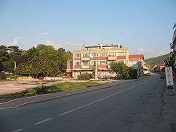 Town Center | ||
| ||
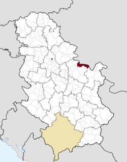 Location of the municipality of Golubac within Serbia | ||
| Coordinates: 44°39′N 21°38′E / 44.650°N 21.633°ECoordinates: 44°39′N 21°38′E / 44.650°N 21.633°E | ||
| Country |
| |
| Region | Southern and Eastern Serbia | |
| District | Braničevo | |
| Settlements | 24 | |
| Government | ||
| • Mayor | Zoran Pajkić | |
| Area[1] | ||
| • Town | 41.74 km2 (16.12 sq mi) | |
| • Municipality | 367.29 km2 (141.81 sq mi) | |
| Elevation | 72 m (236 ft) | |
| Population (2011 census)[2] | ||
| • Town | 1,655 | |
| • Town density | 40/km2 (100/sq mi) | |
| • Municipality | 8,161 | |
| • Municipality density | 22/km2 (58/sq mi) | |
| Time zone | UTC+1 (CET) | |
| • Summer (DST) | UTC+2 (CEST) | |
| Postal code | 12223 | |
| Area code | +381(0)12 | |
| Car plates | PO | |
| Climate | Cfb | |
| Website |
www | |

Golubac (Serbian Cyrillic: Голубац, pronounced [ɡǒlubats]) is a village and municipality located in the Braničevo District of the eastern Serbia. It is situated on the right side of the Danube river. It is bordered by Romania to the east, Veliko Gradište to the west and Kučevo to the south. The population of the village is 1,655 and the population of the municipality is 8,161.
Name
In Serbian, the town is known as Golubac (Голубац). In Romanian is known as Golubăţ; also it was known as Golumbacu Mare or Columbacu. In Hungarian is known as Galambóc, in German as Taubenberg and in Turkish as Güvercinlik which means "dovecote." The name Golubac is derived from golub, which is Serbian for "pigeon" or "dove," and is therefore often translated as "the town of doves."
Its historical names were Columbria, in Latin,as a contraction of (castrum) Columbaria that means city of pigeons (Latin: Columba, Greek: kòlymbos), and as a city derived from Cuppae during pre-Roman times.
History
It was a stronghold called Cuppae during Roman and Early Byzantine times (1-6th century) and turned into a city (Columbria) in 554/5 AD.[3]
Due to many nearby archeological sites and the Đerdap national park, the village is a popular tourist, fishing and sailing destination.
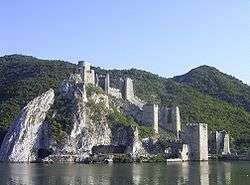
The archeological sites include the remnants of one of Roman Emperor Trajan's tables near Trajan's Bridge, found along his road through the Danube's Iron Gates; and the Roman fortress Diana. Golubac fortress, 4 km downstream, is from the 14th century and also of interest. The fortress was the scene of a battle against the Turks in 1428, where the Polish knight Zawisza Czarny was captured and executed by the Turks.
From 1929 to 1941, Golubac was part of the Morava Banovina of the Kingdom of Yugoslavia.
Demographics
According to the 2011 census results, the municipality of Golubac has a population of 8,331 inhabitants.
Ethnic groups
The ethnic composition of the municipality:[4]
| Ethnic group | Population |
|---|---|
| Serbs | 7,576 |
| Vlachs | 424 |
| Romani | 52 |
| Romanians | 47 |
| Yugoslavs | 13 |
| Montenegrins | 9 |
| Macedonians | 7 |
| Croats | 6 |
| Hungarians | 5 |
| Others | 192 |
| Total | 8,331 |
Tourism
The Iron Gate national park is noted for its natural environment and its hunting grounds, as well as its hiking trails. The village's quay along the Danube river is popular for more relaxed hiking.
Sailing
Golubac has become a well-known sailing site. The Sailing Center of the Sailing Association of Serbia, which the Serbian National Team uses for ground preparations before major sailing events, is located in Golubac. One of the events is a sailing Regatta, which is traditionally held in August. During the summer, the Center holds an Optimist Class sailing camp, where beginners can learn from the best Serbian sailors and their international guests.
See also
References
- ↑ "Municipalities of Serbia, 2006". Statistical Office of Serbia. Retrieved 2010-11-28.
- ↑ "2011 Census of Population, Households and Dwellings in the Republic of Serbia: Comparative Overview of the Number of Population in 1948, 1953, 1961, 1971, 1981, 1991, 2002 and 2011, Data by settlements" (PDF). Statistical Office of Republic Of Serbia, Belgrade. 2014. ISBN 978-86-6161-109-4. Retrieved 2014-06-27.
- ↑ Notitia Dignitatum, the Synekdêmos and Prokopios’s Buildings IV.v.-vii, x
- ↑ "ETHNICITY Data by municipalities and cities" (PDF). stat.gov.rs. Statistical Office of the Republic of Serbia. Retrieved 20 February 2018.
External links
| Wikimedia Commons has media related to Golubac. |
