Bački Petrovac
| Bački Petrovac Бачки Петровац | ||
|---|---|---|
| Town and municipality | ||
 Evangelical Church in Bački Petrovac | ||
| ||
 Location of Bački Petrovac within Serbia | ||
| Coordinates: 45°21′38″N 19°35′30″E / 45.36056°N 19.59167°ECoordinates: 45°21′38″N 19°35′30″E / 45.36056°N 19.59167°E | ||
| Country |
| |
| Province | Vojvodina | |
| District | South Bačka | |
| Government | ||
| • Mayor | Srďan Simiť | |
| Area | ||
| • Town | 63.84 km2 (24.65 sq mi) | |
| • Municipality | 158.35 km2 (61.14 sq mi) | |
| Elevation | 86 m (282 ft) | |
| Population (2011 census)[1] | ||
| • Town | 6,063 | |
| • Town density | 95/km2 (250/sq mi) | |
| • Municipality | 13,302 | |
| • Municipality density | 84/km2 (220/sq mi) | |
| Time zone | UTC+1 (CET) | |
| • Summer (DST) | UTC+2 (CEST) | |
| Postal code | 21470 | |
| Area code(s) | +381(0)21 | |
| Car plates | NS | |
| Website | www.backipetrovac.rs | |

Bački Petrovac (Serbian Cyrillic: Бачки Петровац, Slovak: Báčsky Petrovec; "Bačka Petrovac") is a town and municipality located in the South Bačka District of the autonomous province of Vojvodina, Serbia. The town has a population of 6,063, while Bački Petrovac municipality has 13,302 inhabitants.
Name
In Serbian Cyrillic the town is known as Бачки Петровац, in Serbian Latin as Bački Petrovac, in Slovak as Petrovec or Báčsky Petrovec, in Hungarian as Petrőc, and in German as Petrovacz.
Inhabited places
Bački Petrovac municipality includes the town of Bački Petrovac and the following villages:
Note: for the places with Slovak majority, the names are also given in Slovak.
Bački Petrovac is economical, cultural and administrative center of the municipality. It is a settlement of a town character, while the other three are villages of Pannonian type.
History
Being in south Bačka which according to special climatic and other conditions is one of the most fertile parts of Serbia, very suitable for settling down, here in this region people made their settlements very early. The first written records about Petrovac appears in the 13th century when Petrovac is mentioned as a church parish belonging to Bač County. Later that name is changed into Petrovac. Its first inhabitants were the Hungarians and Serbs. In the first half of the 18th century (1745) the Slovaks settled here. Since then Petrovac developed so that it represents cultural, economic, clerical and political center of the Slovaks in this region.
Economy
Agriculture is the most important economic activity based on the production of field crops (wheat, corn, broom weed, sugar beet, hop), cattle, breeding dud ponetry and vegetable crops. Besides agriculture there is also some industry manufacture, metal and chemical. Manufacture of wood civil engineering, printing activities, etc.
Demographics
Historical population of the town
- 1961: 8,104
- 1971: 7,822
- 1981: 7,729
- 1991: 7,236
Ethnic groups
- Municipality
The ethnic Slovaks form a majority of the population in the municipality. There are 9,751 ethnic Slovaks in the municipality or 66% of population. Other ethnic groups are: Serbs (3,779 or 25.74%), Yugoslavs (293 or 1.99%), and others.
Settlements with Slovak majorities are: Bački Petrovac (Slovak: Báčsky Petrovec), Gložan (Slovak: Hložany), and Kulpin (Slovak: Kulpín). There is one settlement with a Serb majority: Maglić.
- Town
Population of the town of Bački Petrovac include 5,549 Slovaks, 573 Serbs, 169 Yugoslavs, and others.
The town is located in southern Bačka (hence the name), some 25 km northwest of Novi Sad, the capital of Vojvodina. It is the cultural center of Slovaks in the province, and other places in the eponymous municipalities are also inhabited by many Slovaks.
Politics
Seats in the municipality parliament won in the 2012 local elections:
- Democratic Party (10)
- G17 Plus (3)
- LSV (5)
- LDP (3)
- Socialist Party of Serbia (3)
- Slovak Vojvodina Party (2)
- United Serbia (2)
- SNS (2)
International relations
Twin towns — Sister cities
Bački Petrovac is twinned with:
Gallery
.jpg) The "Oldest house in Bački Petrovac" built in 1799
The "Oldest house in Bački Petrovac" built in 1799.jpg) The Evangelist Church in Bački Petrovac
The Evangelist Church in Bački Petrovac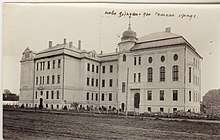 The building of the Jan Kolar gymnasium in Bački Petrovac, first half of the 20th century
.jpg) Matica slovenská in Bački Petrovac
Matica slovenská in Bački Petrovac The Slovak Vojvodina Theatre in Bački Petrovac
.jpg) Workers building a road in Bački Petrovac
Workers building a road in Bački Petrovac Gallery of Zuzka Medveďová in Bački Petrovac
 The Catholic Church in Bački Petrovac
See also
References
- Slobodan Ćurčić, Broj stanovnika Vojvodine, Novi Sad, 1996.
- ↑ "2011 Census of Population, Households and Dwellings in the Republic of Serbia: Comparative Overview of the Number of Population in 1948, 1953, 1961, 1971, 1981, 1991, 2002 and 2011, Data by settlements" (PDF). Statistical Office of Republic Of Serbia, Belgrade. 2014. ISBN 978-86-6161-109-4. Retrieved 2014-06-27.
External links
- Bački Petrovac municipality (in Serbian) and (in Slovak)
- Ján Kollár Grammar School (in Slovak) and (in English)
- Petrovec Online community (in Slovak)
- Matica slovenská v Srbsku (in Slovak)
- Vladimír Hurban Vladimírov Theatre (in Slovak)
- Hlas Ľudu weekly magazine (in Slovak)


| Wikimedia Commons has media related to Bački Petrovac. |