Rožňava
| Rožňava | ||
| Rozsnyó | ||
| Town | ||
 Town center | ||
|
||
| Motto: Mesto s výhľadom | ||
| Country | Slovakia | |
|---|---|---|
| Region | Košice Region | |
| District | Rožňava District | |
| Tourism region | Gemer | |
| River | Slaná | |
| Elevation | 313 m (1,027 ft) | |
| Coordinates | 48°39′30″N 20°31′51″E / 48.65833°N 20.53083°ECoordinates: 48°39′30″N 20°31′51″E / 48.65833°N 20.53083°E | |
| Area | 45.614 km2 (18 sq mi) | |
| Population | 18,368 (31 December 2014) | |
| Density | 403/km2 (1,044/sq mi) | |
| First mentioned | 1291 | |
| Mayor | Pavol Burdiga | |
| Timezone | CET (UTC+1) | |
| - summer (DST) | CEST (UTC+2) | |
| Postal code | 048 01 | |
| Phone prefix | 421-58 | |
| Car plate | RV | |
  Location of Rožňava in Slovakia | ||
 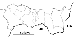 Location of Rožňava in the Košice Region | ||
| Wikimedia Commons: Rožňava | ||
| Statistics: MOŠ/MIS | ||
| Website: http://www.roznava.sk | ||

Rožňava (Hungarian: Rozsnyó, German: Rosenau, Latin: Rosnavia) is a town in Slovakia, approximately 71 kilometres (44 miles) by road from Košice in the Košice Region, and has a population of 19,505.
The town is an economic and tourist centre of the Gemer. Rožňava is now a popular tourist attraction with a beautiful historic town centre. The town is an episcopal seat. It has above all food, textile and remnants of mining industries.
History
Archaeological finds show that the region was densely settled by miners as early as around 1200. The first written mention stems from 1291, the royal free town status from 1410. The Roman Catholic diocese of Rozsnyó was founded in 1776.
In the Middle Ages, Rozsnyó was a prosperous mining town for gold, silver, and iron. Mining activities stagnated from the 16th century (when territories to the south of the town were conquered by Ottoman Turks). Mining - this time mainly of iron ore - was renewed around 1800 and was present in the town throughout the 20th century. It was ruled by Ottoman Empire as part of Filek sanjak (Its centre was Rimaszombat) during periods of 1554-1593 and 1596-1686. It was known as "Rojna" during Ottoman period.
The name of the town probably derives from the German and/or Hungarian words for rose (Rose and Rózsa, respectively).
During World War II, Rožňava was captured on 23 January 1945 by troops of the Romanian 4th Army, acting as a part of the Soviet 2nd Ukrainian Front.
On 13 September 2003, Rožňava was visited by Pope John Paul II.
Noteworthy buildings
- an important Mining Museum
- a completely preserved medieval central town square with burgher houses
- the Cathedral (Gothic, late 13th century) with many precious historic art objects, especially a Renaissance painting of Mestercia showing realistic mining motifs
- the Town Tower (Renaissance, 1654) in the middle of the central town square
- the Jesuit church (Baroque, 1687)
- the Bishop's residence (Baroque-Classical, arose 1778 from older houses) with a plague column in front of the building
- a town hall (Classical, 1711)
- an Evangelic Lutheran church (Classical, 1786)
- a Reformed church (neo-Gothic, 1905)
Demographics
According to the 2001 census, the town had 19,261 inhabitants. 69.27% of inhabitants were Slovaks, 26.80% Hungarians, 1.59% Roma and 0.69% Czechs.[1] The religious make-up was 41.08% Roman Catholics, 32.34% people with no religious affiliation, 12.03% Lutherans and 1.33% Greek Catholics.[1]
Notable citizens
- Pavel Jozef Šafárik, poet and philologist.
- Dana Velďáková, triple jumper
- Jana Velďáková, long jumper
- Henrieta Farkašová, gold medal winner at the 2010 Winter Paralympics and at 2014 Sochi Paralympics
Parts of the town
- Nadabula
- Rožňavská Baňa (Rožňava Mine)
International relations
Twin towns — Sister cities
Rožňava is twinned with:
References
- Notes
- 1 2 "Municipal Statistics". Statistical Office of the Slovak republic. Archived from the original on 2007-12-17. Retrieved 2007-12-28.
External links
- Rožňava
- Information on Rožňava and the Gemer region
- Information on tourist sights (with photo of the main square)
- Medial information site about life in Rožňava (In slovak language)
- Official site (Slovak only)
| Wikimedia Commons has media related to Rožňava. |