Knjaževac
| Knjaževac Књажевац | ||
|---|---|---|
| Town and municipality | ||
 Town centre with bridge over the Timok | ||
| ||
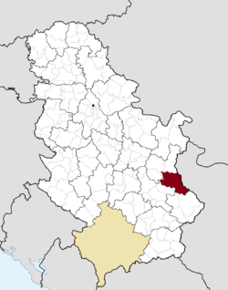 Location of the municipality of Knjaževac within Serbia | ||
| Coordinates: 43°34′N 22°16′E / 43.567°N 22.267°ECoordinates: 43°34′N 22°16′E / 43.567°N 22.267°E | ||
| Country |
| |
| Region | Southern and Eastern Serbia | |
| District | Zaječar | |
| Settlements | 86 | |
| Government | ||
| • Mayor | Milan Đokić (SNS) | |
| Area[1] | ||
| Area rank | 6th | |
| • Town | 22.68 km2 (8.76 sq mi) | |
| • Municipality | 1,202 km2 (464 sq mi) | |
| Elevation | 221 m (725 ft) | |
| Population (2011 census)[2] | ||
| • Town | 18,404 | |
| • Town density | 810/km2 (2,100/sq mi) | |
| • Municipality | 31,491 | |
| • Municipality density | 26/km2 (68/sq mi) | |
| Time zone | UTC+1 (CET) | |
| • Summer (DST) | UTC+2 (CEST) | |
| Postal code | 19350 | |
| Area code | +381(0)19 | |
| Car plates | KŽ | |
| Website |
www | |

Knjaževac (Serbian Cyrillic: Књажевац, pronounced [kɲǎːʒɛʋats]) is a town and municipality located in the Zaječar District of the eastern Serbia. As of 2011, the municipality has a population of 31,491 inhabitants, while the town has 18,404 inhabitants.
The town is situated between three mountains, in the geographical region of the Timočka Krajina bordering Bulgaria.
History
In the Roman period, Timacum Minus existed within the present municipality. In 1833, the town, formerly known as Gurgusovac, was liberated from the Ottoman Empire and was administrated into the Krajina nahija of the Principality of Serbia in 1834. In 1859 the official name was changed to Knjaževac. From 1929 to 1944, Knjaževac was part of the Morava Banovina of the Kingdom of Yugoslavia. In 1944, a train tunnel was built in the town, which is depicted in the town's coat of arms.
Gurgusovac Tower
During the Ottoman period, the fortress, known as the Gurgusovac Tower, after the then name of the town, was built with a purpose to control the Niš-Vidin road. Strategically located, encompassed by the rampart and a deep trench, the fort hosted the company of 100 soldiers. The tower with two floors and a basement was square shaped and the rampart surrounding it was 13 m (43 ft) long, 10 m (33 ft) wide and 2.5 m (8 ft 2 in) tall.[3]
After the liberation from the Ottomans, the fort lost its strategic importance and was turned into a dungeon-type prison. Numerous adversaries of Prince Alexander Karađorđević and the Defenders of the Constitution regime were jailed in the tower. Due to its notoriety because of the torture and abuse, it became a symbol of suffering and was nicknamed the "Serbian Bastille". After Prince Miloš Obrenović returned to Serbia in 1858 and replaced Alexander Karađorđević, he visited Gurgusovac and ordered for the tower to be burned to the ground. The tower was razed, with only one wall and an entry gate remaining, while in order to commemorate the prince's decision, the name of the town of Gurgusovac was changed to Knјаževac ("Prince's town") on 17 January 1859.[3]
In the 2010s, the area of the former tower was adapted into the open-air cultural venue, including the summer stage. The wall and the gate were kept while the additional walls were rebuilt on the remaining foundations.[3]
Geography
The municipality extends over an area of 1202 km2 and is the sixth largest in the Republic of Serbia. Its countryside is mostly hilly and mountainous.
The highest point in the territory of the municipality is Midžor on Stara Planina (2169 m), which is also the second highest peak in the Republic of Serbia. The lowest point is 176 metres high and is situated in the Knjaževac valley. There are 86 inhabited places in the municipality of which 85 are villages. The town itself is situated at the confluence of the Trgoviški Timok and the Svrljiški Timok which become the Beli Timok. It flows on towards Zaječar, merges with the Crni Timok and becomes simply, Timok. It is this river that gives name to the Timočka Krajina region.
Knjaževac is connected with other towns by road and railroad traffic. It is found between the latitudes of 43°20' and 43°45' north and between the longitudes 22°11' and 22°41' east.
Climate
Knjaževac has an oceanic climate (Köppen climate classification: Cfb), that's very close to a humid continental climate (Köppen climate classification: Dfb). The warmest month is July with an average temperature of 21.1 °C (70 °F), whereas the coldest month is January with average temperature of 0.1 °C (32 °F). Average annual rainfall is 605 mm/m2. There are 306 sunny days and 30 days with snow in a year.
| Climate data for Knjaževac | |||||||||||||
|---|---|---|---|---|---|---|---|---|---|---|---|---|---|
| Month | Jan | Feb | Mar | Apr | May | Jun | Jul | Aug | Sep | Oct | Nov | Dec | Year |
| Average high °C (°F) | 3.4 (38.1) |
5.9 (42.6) |
11.7 (53.1) |
16.9 (62.4) |
21.8 (71.2) |
25.2 (77.4) |
27.7 (81.9) |
27.8 (82) |
24.1 (75.4) |
17.7 (63.9) |
9.4 (48.9) |
4.7 (40.5) |
16.4 (61.5) |
| Daily mean °C (°F) | 0.1 (32.2) |
2.2 (36) |
6.7 (44.1) |
11.2 (52.2) |
15.9 (60.6) |
19.1 (66.4) |
21.1 (70) |
21.0 (69.8) |
17.4 (63.3) |
12.2 (54) |
5.6 (42.1) |
1.8 (35.2) |
11.2 (52.2) |
| Average low °C (°F) | −3.2 (26.2) |
−1.5 (29.3) |
1.8 (35.2) |
5.6 (42.1) |
10.1 (50.2) |
13.1 (55.6) |
14.5 (58.1) |
14.2 (57.6) |
10.7 (51.3) |
6.7 (44.1) |
1.9 (35.4) |
−1.0 (30.2) |
6.1 (42.9) |
| Average precipitation mm (inches) | 41 (1.61) |
41 (1.61) |
42 (1.65) |
50 (1.97) |
69 (2.72) |
70 (2.76) |
53 (2.09) |
44 (1.73) |
44 (1.73) |
42 (1.65) |
55 (2.17) |
54 (2.13) |
605 (23.82) |
| Source: Climate-Data.org [4] | |||||||||||||
Demographics
| Historical population | ||
|---|---|---|
| Year | Pop. | ±% p.a. |
| 1948 | 61,560 | — |
| 1953 | 61,973 | +0.13% |
| 1961 | 59,445 | −0.52% |
| 1971 | 52,010 | −1.33% |
| 1981 | 48,789 | −0.64% |
| 1991 | 44,036 | −1.02% |
| 2002 | 37,172 | −1.53% |
| 2011 | 31,491 | −1.83% |
| Source: [5] | ||
According to the 2011 census results, the municipality of Knjaževac has 31,491 inhabitants, of which 18,404 inhabitants live in urban area. The average population density is 26.2 inhabitants per square kilometer making it a sparsely populated municipality.
Ethnic groups
The ethnic composition of the municipality:[6]
| Ethnic group | Population |
|---|---|
| Serbs | 29,631 |
| Romani | 789 |
| Macedonians | 42 |
| Bulgarians | 33 |
| Croats | 23 |
| Albanians | 22 |
| Montenegrins | 20 |
| Vlachs | 20 |
| Yugoslavs | 15 |
| Hungarians | 15 |
| Others | 884 |
| Total | 31,491 |
Economy
The following table gives a preview of total number of employed people per their core activity (as of 2016):[7]
| Activity | Total |
|---|---|
| Agriculture, forestry and fishing | 190 |
| Mining | - |
| Processing industry | 2,283 |
| Distribution of power, gas and water | 44 |
| Distribution of water and water waste management | 154 |
| Construction | 120 |
| Wholesale and retail, repair | 756 |
| Traffic, storage and communication | 180 |
| Hotels and restaurants | 277 |
| Media and telecommunications | 53 |
| Finance and insurance | 48 |
| Property stock and charter | 3 |
| Professional, scientific, innovative and technical activities | 177 |
| Administrative and other services | 60 |
| Administration and social assurance | 341 |
| Education | 459 |
| Healthcare and social work | 574 |
| Art, leisure and recreation | 85 |
| Other services | 95 |
| Total | 5,898 |
Tourism
Knjaževac, with its ski resort Babin Zub offers opportunities for tourism and sports events. Its picnic areas are set in areas of natural beauty (like Banjica, Baranica etc.), places for rest and recreation. The 14th-century Church of the Holy Mother of God lies in the nearby village of Donja Kamenica. In 2014 Knjaževac was chosen as the outstanding destination in Europe. (Project EDEN Network)
Notable people
- Nenad Marinković, footballer
- Milos Milos, actor and bodyguard of Alain Delon
- Aleks Milosevic[8] , Cinematographer, Director of Photography
Gallery
 Knjaževac
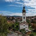 Church in Knjaževac
 Centre of Knjaževac
 Knjaževac
 Knjaževac
 Church in Knjaževac
 Knjaževac
 Villa in Knjaževac
 Memorial park in Knjaževac, dedicated to the soldiers fallen in the liberation wars 1803-1945
International relations
Twin towns — Sister cities
Knjaževac is twinned with:
See also
References
- ↑ "Municipalities of Serbia, 2006". Statistical Office of Serbia. Retrieved 2010-11-28.
- ↑ "2011 Census of Population, Households and Dwellings in the Republic of Serbia: Comparative Overview of the Number of Population in 1948, 1953, 1961, 1971, 1981, 1991, 2002 and 2011, Data by settlements" (PDF). Statistical Office of Republic Of Serbia, Belgrade. 2014. ISBN 978-86-6161-109-4. Retrieved 2014-06-27.
- 1 2 3 Gordana Čanović (1 June 2018). "Српска Бастиља у Књажевцу" [Serbian Bastille in Knjaževac]. Politika-Moja kuća (in Serbian). p. 02.
- ↑ "Climate: Knjaževac, Serbia". Climate-Data.org. Retrieved 18 February 2018.
- ↑ "2011 Census of Population, Households and Dwellings in the Republic of Serbia" (PDF). stat.gov.rs. Statistical Office of the Republic of Serbia. Retrieved 18 February 2018.
- ↑ "ETHNICITY Data by municipalities and cities" (PDF). stat.gov.rs. Statistical Office of Serbia. Retrieved 18 February 2018.
- ↑ "ОПШТИНЕ И РЕГИОНИ У РЕПУБЛИЦИ СРБИЈИ, 2017" (PDF). stat.gov.rs (in Serbian). Statistical Office of the Republic of Serbia. Retrieved 17 February 2017.
- ↑ "Aleks Milosevic". IMDb. Retrieved 2018-01-21.
External links
| Wikimedia Commons has media related to Knjaževac. |
