Rekovac
| Rekovac Рековац | ||
|---|---|---|
| Village and municipality | ||
| ||
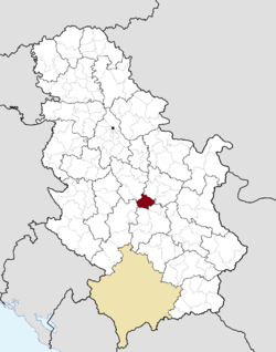 Location of the municipality of Rekovac within Serbia | ||
| Coordinates: 43°52′N 21°08′E / 43.867°N 21.133°ECoordinates: 43°52′N 21°08′E / 43.867°N 21.133°E | ||
| Country |
| |
| Region | Šumadija and Western Serbia | |
| District | Pomoravlje | |
| Settlements | 32 | |
| Government | ||
| • Mayor | Dragan Prodanovic (DS) | |
| Area[1] | ||
| • Municipality | 366 km2 (141 sq mi) | |
| Elevation | 241 m (791 ft) | |
| Population (2011 census)[2] | ||
| • Town | 1,930 | |
| • Municipality | 10,971 | |
| Time zone | UTC+1 (CET) | |
| • Summer (DST) | UTC+2 (CEST) | |
| Postal code | 35260 | |
| Area code | +381(0)35 | |
| Car plates | JA | |
Rekovac (Serbian Cyrillic: Рековац) is a village and municipality located in the Pomoravlje District of central Serbia. According to 2011 census, the population of the village is 1,587, while population of the municipality is 10,971. Rekovac is the center of small geographical region called Levač.
The village has a river called Dulenka, named after one of the settlements in the municipality. There are two schools in Rekovac: a primary school called Svetozar Marković, and a highschool called Poljoprivredno-veterinarska škola.
History
From 1929 to 1941, Rekovac was part of the Morava Banovina of the Kingdom of Yugoslavia.
References
- ↑ "Municipalities of Serbia, 2006". Statistical Office of Serbia. Retrieved 2010-11-28.
- ↑ "2011 Census of Population, Households and Dwellings in the Republic of Serbia: Comparative Overview of the Number of Population in 1948, 1953, 1961, 1971, 1981, 1991, 2002 and 2011, Data by settlements" (PDF). Statistical Office of Republic Of Serbia, Belgrade. 2014. ISBN 978-86-6161-109-4. Retrieved 2014-06-27.
External links
| Wikimedia Commons has media related to Rekovac. |


This article is issued from
Wikipedia.
The text is licensed under Creative Commons - Attribution - Sharealike.
Additional terms may apply for the media files.