Ruma
| Ruma Рума | ||
|---|---|---|
| Town and municipality | ||
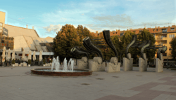 City square | ||
| ||
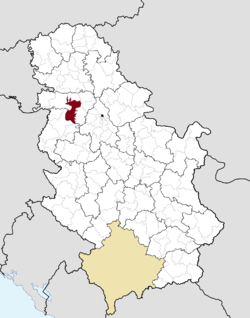 Location of the municipality of Ruma within Serbia | ||
| Coordinates: 45°00′N 19°50′E / 45.000°N 19.833°ECoordinates: 45°00′N 19°50′E / 45.000°N 19.833°E | ||
| Country |
| |
| Province | Vojvodina | |
| District | Srem | |
| Settlements | 17 | |
| Government | ||
| • Mayor | Slađan Mančić (SNS) | |
| Area[1] | ||
| • Town | 68.66 km2 (26.51 sq mi) | |
| • Municipality | 582.02 km2 (224.72 sq mi) | |
| Elevation | 112 m (367 ft) | |
| Population (2011 census)[2] | ||
| • Town | 30,076 | |
| • Town density | 440/km2 (1,100/sq mi) | |
| • Municipality | 54,339 | |
| • Municipality density | 93/km2 (240/sq mi) | |
| Time zone | UTC+1 (CET) | |
| • Summer (DST) | UTC+2 (CEST) | |
| Postal code | 22400 | |
| Area code | +381(0)22 | |
| Car plates | RU | |
| Website |
www | |

Ruma (Serbian Cyrillic: Рума) is a town and municipality located in the Srem District of the Autonomous Province of Vojvodina, Serbia. As of 2011, the town has a population of 30,076, while the municipality has a population of 54,339 inhabitants.
History
Traces of organized human life on the territory of Ruma municipality date back as far as prehistory. The most important archaeological locality in the municipality is Bronze Age Gomolava[3] near Hrtkovci, with two exclusive tombs of Bosut culture dating to the 9th century BC[4] and 3000BC Vučedol culture pottery.[5] The first known inhabitants of this area were various peoples of Illyrian and Celtic origin, such as the Amantini, Breuci, Scordisci, etc. During the Roman rule, local inhabitants lost their ethnic character and adopted Roman culture. There were no larger Roman settlements on the territory of Ruma, but a certain number of agricultural estates known as "villae rusticae" were located there.
Migrations of Huns, Germanic peoples, Avars and Slavs destroyed Roman culture in this area. During the following centuries, the region was ruled by Frankish Empire, Bulgarian Empire, Byzantine Empire and Kingdom of Hungary.
The settlement named Ruma was first mentioned in an Ottoman defter from 1566/7. In that period Ruma was a village inhabited by Serbs, with 49 houses, a church and three priests.[6]
From 1718, Ruma was under administration of the Habsburg Monarchy. In 1746, the town of Ruma was founded near the original village of Ruma. The first inhabitants of the town were Serbs,[6] who came from neighboring settlements, as well as Germans, who came from Germany. In the beginning of the 19th century, Croats and Hungarians settled there as well. In 1807, a large rebellion of the Syrmian peasants known as the Tican's Rebellion started on the territory of Ruma, with its center in the village of Voganj. During the 1848-1849 revolution, Ruma was one of the important centers of the Serbian national movement in Syrmia.
In the late 19th and early 20th century, Ruma was a district capital in the Syrmia County of the Kingdom of Croatia-Slavonia. According to the 1910 census, the population of the Ruma municipality was 49,138 inhabitants, of whom 22,956 spoke Serbian, 15,529 German, 5,746 Hungarian, and 3,730 Croatian.[7]
After the collapse of the Habsburg Monarchy, on November 24, 1918, the Assembly of Syrmia in Ruma proclaimed the unification of Syrmia with the Kingdom of Serbia. In 1933, Ruma officially gained the status of a city.
When World War II began, Ruma was one of the centers of German national minority in Vojvodina.[6] In 1942, during the Axis occupation of Syrmia, a unit of the Third Reich's Wehrmacht, known as the Volunteer Company Ruma ES der DM, was formed from local Volksdeutsche volunteers.[8] A large number of non-German citizens of Ruma participated in the anti-fascist struggle against Axis occupation.[9] In 1944, as a consequence of the war, most members of the German ethnic minority left the town escaping from Yugoslav partisans and Soviet Red Army.[9]
After the war, colonists from various parts of the former Yugoslavia settled this area. During the 1990s, about 10,000 refugees from Croatia, Bosnia and Kosovo settled in Ruma as well. In 1949 the Union of Pilots of Yugoslavia (Vazduhoplovni Savez Jugoslavije) opened a pilot school, a school for parachute instructors and a school of aircraft modelling in Ruma, all of which were funded by the Airforces of Yugoslavia. This led to an impressive International air show held in the center of the town in 1950.
Inhabited places
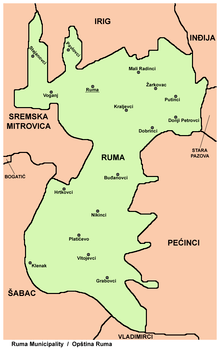
The Ruma municipality comprises the town of Ruma and the following villages:
Demographics
| Historical population | ||
|---|---|---|
| Year | Pop. | ±% p.a. |
| 1948 | 37,622 | — |
| 1953 | 40,742 | +1.61% |
| 1961 | 47,671 | +1.98% |
| 1971 | 52,156 | +0.90% |
| 1981 | 55,083 | +0.55% |
| 1991 | 55,087 | +0.00% |
| 2002 | 60,006 | +0.78% |
| 2011 | 54,339 | −1.10% |
| Source: [10] | ||

According to the 2011 census results, the municipality of Ruma has 54,339 inhabitants.
Ethnic groups
The municipality of Ruma has many ethnic groups, with Serbs constituting a majority in all settlements. The ethnic composition of the municipality of Ruma:[11]
| Ethnic group | Population |
|---|---|
| Serbs | 46,891 |
| Croats | 1,719 |
| Romani | 1,297 |
| Hungarians | 1,171 |
| Yugoslavs | 267 |
| Macedonians | 153 |
| Albanians | 57 |
| Montenegrins | 54 |
| Slovaks | 50 |
| Germans | 49 |
| Muslims | 39 |
| Others | 2,592 |
| Total | 54,339 |
Economy
The following table gives a preview of total number of employed people per their core activity (as of 2016):[12]
| Activity | Total |
|---|---|
| Agriculture, forestry and fishing | 422 |
| Mining | 1 |
| Processing industry | 4,752 |
| Distribution of power, gas and water | 233 |
| Distribution of water and water waste management | 237 |
| Construction | 613 |
| Wholesale and retail, repair | 1,818 |
| Traffic, storage and communication | 775 |
| Hotels and restaurants | 277 |
| Media and telecommunications | 101 |
| Finance and insurance | 131 |
| Property stock and charter | 5 |
| Professional, scientific, innovative and technical activities | 274 |
| Administrative and other services | 116 |
| Administration and social assurance | 560 |
| Education | 711 |
| Healthcare and social work | 738 |
| Art, leisure and recreation | 140 |
| Other services | 194 |
| Total | 12,096 |
Notable citizens
- Aleksandar Berček, actor
- Miloš Bosančić, Serbian footballer
- Brana Crnčević, writer
- Teodor Filipović (Boža Grujović), first secretary of "Praviteljstvujušči sovjet" in Karađorđe's Serbia.
- Stjepko Gut, jazz musician
- Paško Rakić, neuroscientist
- Atanasije Stojković, scientist and writer
- Dragan Šarac, former Serbian footballer
- Alois Weiss, executioner
- Rajka Vali, singer
- Danilo Pantić, Serbian football player
- Vjekoslav Servatzy, Croatian Ustaše military officer, war criminal
Sister cities

Image gallery
 The Orthodox church
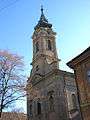 The Catholic church
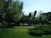 Monument in the center of the city
 Borkovac Lake
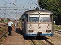 A junction train from Ruma to Šabac
See also
References
- ↑ "Municipalities of Serbia, 2006". Statistical Office of Serbia. Retrieved 2010-11-28.
- ↑ "2011 Census of Population, Households and Dwellings in the Republic of Serbia: Comparative Overview of the Number of Population in 1948, 1953, 1961, 1971, 1981, 1991, 2002 and 2011, Data by settlements" (PDF). Statistical Office of Republic Of Serbia, Belgrade. 2014. ISBN 978-86-6161-109-4. Retrieved 2014-06-27.
- ↑ "CEEOL BALCANICA , Issue XXXVI /2005". Ceeol.com. Retrieved 2013-10-15.
- ↑ Nikola Tasic. "Historical Picture of Development of Early Iron Age in the Serbian Danube Basin" (PDF). Balkaninstitut.com. Retrieved 22 February 2015.
- ↑ "Balcanica XXXVI" (PDF). Balkaninstitut.com. Retrieved 22 February 2015.
- 1 2 3 "History". Ruma.rs. 1944-10-27. Archived from the original on 2013-10-15. Retrieved 2013-10-15.
- ↑
- ↑ "Axis History". Axishistory.com. Retrieved 2013-10-15.
- 1 2 "Opština Ruma - Istorija" (in Serbian). Internet Media. 2006. Retrieved 2010-11-14.
- ↑ "2011 Census of Population, Households and Dwellings in the Republic of Serbia" (PDF). stat.gov.rs. Statistical Office of the Republic of Serbia. Archived from the original (PDF) on 14 July 2014. Retrieved 28 May 2017.
- ↑ "ETHNICITY Data by municipalities and cities" (PDF). stat.gov.rs. Statistical Office of the Republic of Serbia. Retrieved 22 February 2018.
- ↑ "ОПШТИНЕ И РЕГИОНИ У РЕПУБЛИЦИ СРБИЈИ, 2017" (PDF). stat.gov.rs (in Serbian). Statistical Office of the Republic of Serbia. Retrieved 22 February 2018.
External links
| Wikimedia Commons has media related to Ruma. |


