Majdanpek
| Majdanpek Мајданпек | ||
|---|---|---|
| Town and municipality | ||
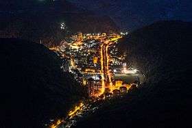  From top: Majdanpek panorama, Donji Milanovac town panorama | ||
| ||
 Location of the municipality of Majdanpek within Serbia | ||
| Coordinates: 44°25′N 21°56′E / 44.417°N 21.933°ECoordinates: 44°25′N 21°56′E / 44.417°N 21.933°E | ||
| Country |
| |
| Region | Southern and Eastern Serbia | |
| District | Bor | |
| Settlements | 14 | |
| Government | ||
| • Mayor | Dejan Vagner (SNS) | |
| Area[1] | ||
| Area rank | 15th | |
| • Town | 178.08 km2 (68.76 sq mi) | |
| • Municipality | 931.70 km2 (359.73 sq mi) | |
| Elevation | 362 m (1,188 ft) | |
| Population (2011 census)[2] | ||
| • Rank | 77th | |
| • Town | 10,109 | |
| • Town density | 57/km2 (150/sq mi) | |
| • Municipality | 18,686 | |
| • Municipality density | 20/km2 (52/sq mi) | |
| Time zone | UTC+1 (CET) | |
| • Summer (DST) | UTC+2 (CEST) | |
| Postal code | 19250 | |
| Area code | +381(0)30 | |
| Car plates | BO | |
| Website |
www | |

Majdanpek (Serbian Cyrillic: Мајданпек) is a town and municipality located in the Bor District of the eastern Serbia. According to 2011 census, the municipality of Majdanpek had a population of 18,686 people, while the town of Majdanpek had a population of 10,109.
Name
The name "Majdanpek" is derived from the words majdan meaning "quarry" (from Arabic maydān) and pek meaning "much, big, very" in Turkish. In Serbian Vlach (and Romanian), the town is known as simply Maidan.
History
The transition out of the Stone Age occurred between 6000 BCE and 2500 BCE for much of humanity living in North Africa and Eurasia. The first evidence of human metallurgy dates to between the 5th and 6th millennium BCE in the archaeological sites of Majdanpek, Yarmovac, and Pločnik in modern-day Serbia (a copper axe from 5500 BCE belonging to the Vinca culture), though not conventionally considered part of the Chalcolithic or "Copper Age", this provides the earliest known example of copper metallurgy.[3] Chalcolithic excavations exist in Kapetanova Pecina, Praurija, Kameni Rog and Roman site of Kamenjar.
The town is famous as a copper mine district, since the early 17th century. The origin of the name is based on words majdan (related to Turkish madän, mine) and river Pek - mine on river Pek. Throughout its history, mining development was held by many foreign owners (Czechs, Belgians, Austrians), and was extensively exploited. The town was industrialized in the mid-20th century, by the industrial program supported by SFR Yugoslavia's Government of that time, and the personal influence of J.B.Tito (marshal and lifetime prime minister since the end of World War II until 1980). Through the late 20th century, the town was in a period of industrial progress and one of the most developed areas in copper mining and metallurgy.
Geography
Climate
Majdanpek has a humid continental climate (Köppen climate classification: Dfb).
| Climate data for Majdanpek | |||||||||||||
|---|---|---|---|---|---|---|---|---|---|---|---|---|---|
| Month | Jan | Feb | Mar | Apr | May | Jun | Jul | Aug | Sep | Oct | Nov | Dec | Year |
| Average high °C (°F) | 1.7 (35.1) |
3.3 (37.9) |
9.1 (48.4) |
14.9 (58.8) |
19.9 (67.8) |
23.0 (73.4) |
25.6 (78.1) |
25.7 (78.3) |
21.8 (71.2) |
15.3 (59.5) |
7.6 (45.7) |
2.8 (37) |
14.2 (57.6) |
| Daily mean °C (°F) | −1.2 (29.8) |
0.1 (32.2) |
4.7 (40.5) |
9.7 (49.5) |
14.6 (58.3) |
17.6 (63.7) |
19.6 (67.3) |
19.5 (67.1) |
15.9 (60.6) |
10.6 (51.1) |
4.4 (39.9) |
0.3 (32.5) |
9.7 (49.4) |
| Average low °C (°F) | −4.0 (24.8) |
−3.1 (26.4) |
0.4 (32.7) |
4.6 (40.3) |
9.3 (48.7) |
12.2 (54) |
13.6 (56.5) |
13.4 (56.1) |
10.0 (50) |
5.9 (42.6) |
1.1 (34) |
−2.2 (28) |
5.1 (41.2) |
| Average precipitation mm (inches) | 45 (1.77) |
44 (1.73) |
45 (1.77) |
57 (2.24) |
80 (3.15) |
93 (3.66) |
72 (2.83) |
58 (2.28) |
50 (1.97) |
44 (1.73) |
55 (2.17) |
56 (2.2) |
699 (27.5) |
| Source: Climate-Data.org [4] | |||||||||||||
Settlements
The municipality includes the following settlements:
- Towns
- Majdanpek
- Donji Milanovac
- Villages
Demographics
| Historical population | ||
|---|---|---|
| Year | Pop. | ±% p.a. |
| 1948 | 19,610 | — |
| 1953 | 21,155 | +1.53% |
| 1961 | 23,022 | +1.06% |
| 1971 | 26,120 | +1.27% |
| 1981 | 26,628 | +0.19% |
| 1991 | 27,378 | +0.28% |
| 2002 | 23,703 | −1.30% |
| 2011 | 18,686 | −2.61% |
| Source: [5] | ||
According to the 2011 census results, the municipality of Majdanpek has a population of 18,686 inhabitants.
Ethnic groups
Most of the settlements in the Majdanpek municipality have Serb ethnic majority. The settlement with Vlach ethnic majority is Vlaole. Ethnically mixed settlement with relative Vlach majority is Jasikovo. The ethnic composition of the municipality:[6]
| Ethnic group | Population |
|---|---|
| Serbs | 14,670 |
| Vlachs | 2,442 |
| Montenegrins | 70 |
| Romanians | 68 |
| Macedonians | 56 |
| Yugoslavs | 51 |
| Croats | 33 |
| Bulgarians | 22 |
| Others | 1,274 |
| Total | 18,686 |
Tourism
One of the most notable tourist attractions in Majdanpek is Rajkova Pećina (Rajko's Cave).[7][8]
Economy
The following table gives a preview of total number of employed people per their core activity (as of 2016):[9]
| Activity | Total |
|---|---|
| Agriculture, forestry and fishing | 125 |
| Mining | 1,097 |
| Processing industry | 740 |
| Distribution of power, gas and water | 52 |
| Distribution of water and water waste management | 96 |
| Construction | 118 |
| Wholesale and retail, repair | 380 |
| Traffic, storage and communication | 149 |
| Hotels and restaurants | 126 |
| Media and telecommunications | 38 |
| Finance and insurance | 20 |
| Property stock and charter | - |
| Professional, scientific, innovative and technical activities | 45 |
| Administrative and other services | 57 |
| Administration and social assurance | 276 |
| Education | 320 |
| Healthcare and social work | 299 |
| Art, leisure and recreation | 59 |
| Other services | 33 |
| Total | 4,030 |
Gallery
 Majdanpek Downtown
 Majdanpek Mines
 Majdanpek Nature
 Donji Milanovac Monument
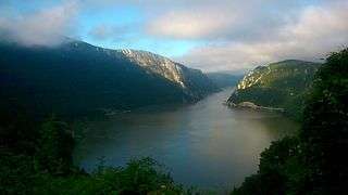
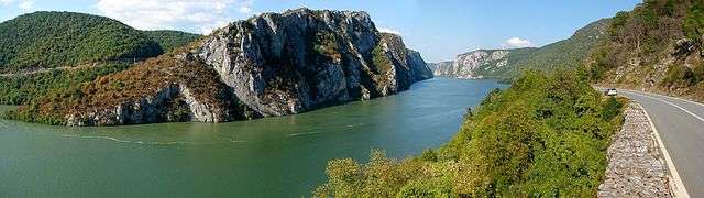 Đerdap national park
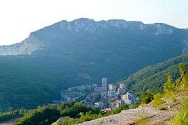
 Donji Milanovac panorama
Notable people
- Dejan Petkovic (born 1972), Serbian football player
See also
References
- ↑ "Municipalities of Serbia, 2006". Statistical Office of Serbia. Retrieved 2010-11-28.
- ↑ "2011 Census of Population, Households and Dwellings in the Republic of Serbia: Comparative Overview of the Number of Population in 1948, 1953, 1961, 1971, 1981, 1991, 2002 and 2011, Data by settlements" (PDF). Statistical Office of Republic Of Serbia, Belgrade. 2014. ISBN 978-86-6161-109-4. Retrieved 2014-06-27.
- ↑ "Neolithic Vinca was a metallurgical culture". Archaeo News. Reuters. 17 November 2007. Retrieved 25 January 2011.
- ↑ "Climate: Majdanpek, Serbia". Climate-Data.org. Retrieved December 27, 2017.
- ↑ "2011 Census of Population, Households and Dwellings in the Republic of Serbia" (PDF). Stat.gov.rs. Statistical Office of the Republic of Serbia. Archived from the original (PDF) on 14 July 2014. Retrieved 11 January 2017.
- ↑ "2011 Census of Population, Households and Dwellings in the Republic of Serbia" (PDF). Stat.gov.rs. Statistical Office of the Republic of Serbia. Archived from the original (PDF) on 11 August 2014. Retrieved 5 January 2017.
- ↑ "Archived copy". Archived from the original on 2010-04-03. Retrieved 2010-03-31.
- ↑ "Turizam - Srbija - Majdanpek - Rajkova pecina - Rajko's cave". Paundurlic.com. Retrieved 28 December 2017.
- ↑ "ОПШТИНЕ И РЕГИОНИ У РЕПУБЛИЦИ СРБИЈИ, 2017" (PDF). stat.gov.rs (in Serbian). Statistical Office of the Republic of Serbia. Retrieved 17 February 2017.
External links
| Wikimedia Commons has media related to Majdanpek. |
